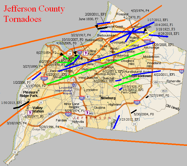
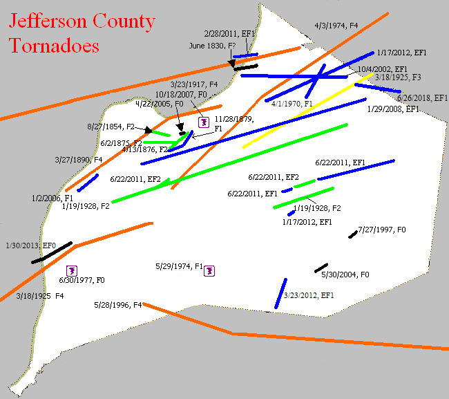
June 1830
Counties: Clark IN and Jefferson KY
F-scale:
Deaths:
Injuries:
Path width: 70 yards
Path length:
Time:
Narrative: Moved east, crossing the Ohio River about 6 miles "north" (upstream?) of Louisville, knocking down trees and fences.
August 27, 1854
Counties: Jefferson KY
F-scale: F2
Deaths: 25
Injuries: 100
Path width: 800 yards
Path length: 2 miles
Time: 12:12pm
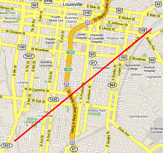
Notes: This deadly storm touched down near the intersection of Jefferson and Twentieth Streets, unroofing 21 buildings at the German Protestant Orphan Asylum. The Louisville Daily Courier described the storm as "a whirlwind revolving leftwise." The tornado appears to have travelled in an east-southeasterly direction. Seventeen houses were damaged along Walnut Street from Fifteenth to Seventeenth Streets, a home was severely damaged near the corner of Madison and Thirteenth Streets, and a factory was damaged at the corner of Chestnut and Twelfth Streets. However, the most catastrophic damage occurred when the tornado destroyed the Third Presbyterian Church at Walnut and Eleventh Streets. At a quarter past noon during Sunday services the twister struck the church, causing it to collapse. A door was opened by gusts of wind just moments prior to the tornado, and this may have been one factor in the destruction of the church as powerful tornado winds battered the outside of the building and also were allowed to sweep into the interior of the building. Many women and children were killed, the youngest victim being nine years old. A mother and her three children were discovered grouped in death, and in another spot a father lay dead with the mother mortally wounded, their young child placed beneath them unhurt, protected by the forms of its parents. The toll in the church was about 18 to 20 dead, out of the 55 who were in the church at the time. From the Daily Courier, describing the aftermath of the destroyed church, "Each piercing shriek reveals the fact that some new dead form has been brought to light. Here comes a father borne along by his friends, who take him from his bed of death; next the mother, then the daughter and two sons -- all crushed -- mutilated -- dead!" The church was scheduled to be dedicated the following Sunday. A Mr. Joseph Bradley, while assisting in removing victims from the rubble immediately after the storm, had his eye cut out by a hatchet wielded by a nearby person removing fallen rafters. Mr. Bradley made a full recovery. It was noted in subsequent days that the church was very poorly constructed. People would cross the street rather than walk by it. The Daily Courier noted, "There was scarcely any more cohesiveness in the mortar in the brickwork than if had been made of sand and water." Older, shabbier buildings in the storm were less damaged than the church full of parishioners. Moving on from the church, the tornado tore off rooftops along Tenth, Ninth, and Eighth Streets between Chestnut Street and Broadway. A new frame home was destroyed on Sixth Street just south of Broadway, and chimney and other miscellaneous damage occurred along Broadway between Fifth and Fourth Streets as the tornado began to dissipate. The final damage was that of an unroofed house at the corner of Breckenridge and Fifth Streets. It was the worst disaster seen in Louisville up to that time. At least a hundred buildings were affected. Mayor James Speed ordered all businesses in the city closed the next day.
Side note: Interestingly, in researching this event, we found two distinct paths of destruction across Louisville (see map). The path described above was more certainly a tornado. The other path was parallel to the tornado and about half a mile to the north, on the west edge of downtown. Significant destruction was done on Main Street between Ninth and Eighth Streets where two of the "best and most substantial business houses in the city were scattered as though they had been made of cards," with the walls collapsing inward. A factory was damaged on Main Street just west of Ninth Street, in the Tobacco District. Boats in the Ohio River wwre blown loose of their moorings and landed on the falls. Many boats were damaged and some were totally destroyed, including a steamboat. Four houses were even blown down across the river in Jeffersonville. Significant damage continued until the intersection of Main and Sixth Streets. Beyond that, slight damage was done to the Walnut Street Baptist Church (corner of Fourth Street and Muhammad Ali Boulevard), and worshippers participating in Mass at the cathedral on Fifth Street were blown off their feet. It has been decided, to the best of our ability, that these events were due to straight-line winds. Also, the storm brought extremely heavy rain that caused Beargrass Creek to flood, but the rains were generally welcome as the region had been suffering through a severe drought.
June 2, 1875
Counties: Jefferson KY
F-scale: F2
Deaths: 0
Injuries: 2 (known)
Path width: 880 yards
Path length: 3 miles
Time: 7:00pm local time
Notes: This storm swept through the southern half of Louisville with the primary damage swath a mile wide. However the actual tornado appears to have been about half a mile wide, embedded within the wind damage. The tornado moved from west to east, generally bounded by Kentucky Street on the north and Oak Street on the south. The first damage from the tornado took place along Eighteenth Street (today's Dixie Highway). Large brick homes lost their roofs on 18th at Prentice and at Oak. Proceeding to the east, some of the most concentrated damage was done along Harney and Churchill Streets (both now Saint Catherine) from Sixteenth Street to Tenth Street. A stable was destroyed and a frame home "was knocked higher than a kite" on Harney between Fifteenth and Sixteenth (just east of today's California Park). A frame cottage was entirely destroyed and a three-story brick residence lost its facade along Churchill between Fifteenth and Fourteenth. Homes were unroofed on both the east and west sides of the intersection of Churchill at Thirteenth. Cottages were destroyed on the southeast corner of Churchill and Twelfth. A brick house on Twelfth between Churchill and Oldham was blown down. Cottages were destroyed at Churchill and Eleventh and a brick house was blown down just south of that intersection. In the block bordered by Kentucky, Oak, Eleventh, and Tenth (along Oldham Street) the Louisville Bridge Company building was wrecked, with only the northern part of it (which was on the northern fringe of the tornado) still standing. The rest of the building was leveled to the ground. Homes lost their roofs along Oak Street at Sixth, between Fifth and Fourth, and at Fourth. Houses were damaged at Churchill and Fourth, and the Baptist Orphan's Home lost its roof at Churchill and First. The tornado may have then turned to the left (northeast) as it caused F2-level damage to a two-story brick dwelling near the corner of Breckinridge and Preston. It dissipated shortly thereafter. Significant wind damage occurred outside the tornado's path. Strong winds, possibly a result of a phenomenon known as a "rear flank downdraft" or RFD, blew down the length of Magnolia Street from Twelfth to Third. Saints Mary and Elizabeth Hospital lost part of its roof at Twelfth, roofs were lost at Sixth, and homes were damaged at Fourth and Third. As the tornado turned to the northeast, so did the RFD, and a two-and-a-half story house lost its roof in Germantown (which the 1875 newspaper described as a "remote suburb") at Mary and Logan Streets. The final damages northeast of the tornado's endpoint were at Chestnut and Madison where a horse-and-buggy were turned over and at Main and Jackson (site of today's Slugger Field) where a tree was blown down. However, some of the most significant damage of the storm took place almost a mile south of where this project feels the true tornado took place. The Masonic Home for Widows and Orphans was located where DuPont Manual High School is today. The facility was shaped somewhat like a squat capital "H," with the relatively longer sides of the H lined up along B Street and C Street (now Bloom Street and Cardinal Boulevard), and the short connecting section parallel to First and Second Streets (the two longer sides of the "H" had been stand-alone buildings, and were subsequently connected by the short middle section of the "H"). When the storm came through, the entire middle section of the building was obliterated. It's interesting to note that the part that was destroyed was aligned north-south, so that a strong west wind, which would be typical of an RFD, would have hit it broadside. Or, it's also possible that a small satellite vortex spun out of the main tornado to the north. Fortunately the section that was demolished was so new that it hadn't even been moved in to yet. However, two boys at the home were hurt. Click here for an incredible picture of the damage (courtesy of the University of Louisville Photographic Archives).
April 13, 1876
Counties: Jefferson KY
F-scale: F2
Deaths: 2
Injuries: 10
Path width: 50 yards
Path length: 3 miles
Time: 6:30pm
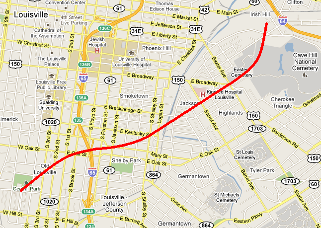
Narrative: A tornado touched down west of present-day University of Louisville and moved to the north-northeast across eastern sections of the city. The tornado struck the brand new baseball park, located where Saint James Court is today, built to host Louisville's new National League baseball team, the Louisville Grays. The park was badly damaged, just 12 days before the season's Opening Day. The park was quickly repaired and was ready to go in time for the first pitch. The tornado continued northeast across the land that would become Central Park, and into Eagle Park between Ormsby and Park Avenues and Third and Fifth Streets. Eagle Park was Louisville's baseball park before the new one to the south was constructed. Eagle Park was demolished, and the baseball diamond's bleachers were destroyed. Damage was then fairly sparse until the tornado entered the Germantown and Phoenix Hill neighborhoods. Germantown was hardest hit. A two story brick home was damaged "about as complete(ly) as it could possibly be" and a man and his son were killed in the home, on the northeast corner of Payne and Logan Streets (those streets do not intersect today, so this exact location is unknown). Mills on Broadway at Beargrass Creek were wrecked. Houses were severely damaged on Green Street (now Liberty Street) near Campbell. Blacksmith shops on Preston "near the railroad crossing (?) were blown down. Half a dozen houses were damaged on Milk Street (?) at Shelby Street. The Exposition Building and its skating rink were damaged. Light damage was reported on Walnut Street (now Muhammad Ali Blvd). Most of the injuries in the tornado were in a street car that was hit by the roof of a house. Click here for a detailed map of the approximate path of the tornado.
November 28, 1879
Counties: Jefferson KY
F-scale: F1
Deaths:
Injuries: several
Path width:
Path length:
Time: 6:04pm
Narrative: A tornado, which possessed a "wrenching, spiral motion" according to witnesses and was described in the newspaper as "whirling and tossing about like a monster in pain" moved northeast through the southeast part of Louisville, damaging over a hundred buildings. A warehouse containing five hundred barrels of whiskey was destroyed. The tornado touched down near the intersection of Saint James Court and Magnolia Avenue, where it tore down several fences in Central Park. The first home damaged was on Fourth Street opposite the park. Eagle Park (primarily used for baseball) was damaged between Third and Fourth streets and Ormsby and Park avenues, and a home was damaged on Third Street opposite the park. Considerable damage was done in what was then known as Brownstown, and today is Old Louisville. Many roofs were removed there, and damage was reported at the corner of First and Ormsby. The tornado then intensified and produced some of its worst damage at Preston Street and Mechanic Street (Mechanic Street was today's Saint Catherine and Mary streets). Houses were unroofed at the intersection of Preston and Mechanic, a small brick slaughterhouse on Mechanic was demolished, and a two and a half story brick house on Mechanic was badly damaged. Continuing to the northeast, a home was damaged at the corner of Kentucky and Shelby streets and brick cottages on Kentucky near Shelby were wrecked. A roof was removed on Mary Street near Swan Street, and some light damage was done along Fischer Avenue, though those damages were probably from straight-line winds. The tornado advanced to the northeast. Significant damage occurred on Broadway near Cave Hill Cemetery. The twister then moved into the cemetery and inflicted terrible damage to trees and monuments. The arch over the northern gateway was blown over. The tornado lifted in the Irish Hill neighborhood. Click here for a detailed map of the approximate path of the center of the tornado.
March 27, 1890
Counties: Jefferson KY, Clark IN
F-scale: F4
Deaths: 76
Injuries: 200
Path width: 300 yards
Path length: 15 miles
Time: 7:57pm
Narrative: One of the most devastating tornadoes to ever strike Kentucky. This historic event may have actually started in Harrison County IN, but is traditionally plotted from west of Shively, Kentucky, in western Jefferson County. The tornado moved north-northeast and northeast through the Parkland neighborhood (Twenty-eighth and Dumesnil), leveling a few homes. This F4 damage was the only clear example of F4 strength winds along the path. However, when the tornado entered the city of Louisville it was 200 yards wide and grew to 500 yards wide as it plowed through the central business district downtown. Multi-story downtown buildings were hit by the tornado and subsequently collapsed. At least 44 deaths occurred at the Falls City Hall (1124 West Market Street). The building collapsed with 200 people inside; 75 at a lodge meeting on the upper floor and 125 children with their mothers taking dancing lessons on the lower floor. This was one of the highest tornado death totals in a single building ever recorded in the United States. Damage totalled $2.5 million (1890 dollars) in Jefferson County, with another half a million dollars with F2 intensity damage in Jeffersonville IN...along with 20 injuries. The tornado then turned to the right and re-crossed the Ohio River, coming back into Louisville dissipating near the present-day intersection of Zorn Avenue and River Road after badly damaging the city water tower. 5 churches, 7 railroad depots, 2 public halls, 3 schools, 10 tobacco warehouses, 32 manufacturing plants and 532 dwellings were destroyed by the tornado. Union Station was crushed as well. The next morning the newspaper called the storm "the whirling tiger of the air". The city organized crews of 60 men each who worked day and night searching the wreckage, along with families and friends. Sightseers started arriving the next day, and the Guard was called to control the crowds. The City refused any outside aid. The Board of Trade organized a relief committee to oversee the recovery, and the Board also authorized $15,000 in pensions to widows and orphans of the storm.
March 23, 1917
Counties: Harrison IN, Floyd, Clark IN, Jefferson KY
F-scale: F4
Deaths: 46
Injuries: 250
Path width: 400 yards
Path length: 33 miles
Time: 3:08pm
Narrative: One of the worst tornadoes in Kentuckiana's history. This large tornado passed one mile north of Corydon as it moved east across central Harrison County. Many farm buildings were damaged, and one farm was almost completely blown away. Its occupant was found in a ditch 200 feet from the foundation, unconscious, critically injured, and holding her unharmed baby. The twister moved east-northeast from three miles west of New Albany and cut a swath of death and destruction through the north side of town. Damage totaled $1,500,000 as 500 homes were destroyed, along with two schools and many other buildings. While many homes were swept away, the deaths were concentrated in groups, including at least five (possibly 12) deaths at the Olden Street School, eight deaths at a wood specialties plant, and five deaths in one home. Some children were killed on their way home from school. The tornado dissipated after striking Harrod's Creek, Kentucky.
Note: Grazulis counts this as two tornadoes, with a gap in the path at the Harrison/Floyd County line. More recent research by Gary Purlee and Cody Moore indicate that this was actually one tornado.
March 18, 1925
Counties: Harrison IN, Jefferson KY
F-scale: F4
Deaths: 4
Injuries: 60
Path width: 1200 yards
Path length: 18 miles
Time: 5:15pm
Narrative: Moved to the east-northeast from Mauckport to just south of Louisville. Up to a mile wide, this very intense tornado swept away entire farms as it passed one mile north of Laconia and two miles south of Elizabeth. Furniture from Indiana was later found in yards in Pleasure Ridge Park, KY. The four deaths were in two separate Indiana farm homes. Jefferson County locations that were struck by the tornado or its parent thunderstorm included Orell, Greenwood Station, Kerrick Station, Blanton Station, Saint Helens, South park, Iroquois Park, and Senning's Park. The worst damage was on Eighteenth Street Road (likely today's Dixie Highway) from Lakeland to Blanton Station (the Pleasure Ridge Park/Dixie Manor Shopping Center area today). Three people were killed there. Nothing was left standing from the river to Blanton Station in a swatch two blocks wide. The twister crossed Cane Run Road and demolished a home on Greenwood Road. Damage was severe at Saint Helens, with one house completely removed except for one interior room. A two-story brick home was destroyed at Lakeland. Trees and power lines were torn down along Eighteenth Street Road from Kerrick Station to Greenwood Road...a distance of about a mile. Garages were destroyed in Senning's Park (site of Louisville's zoo at the time, located across New Cut Road from the Iroquois Amphitheater). Fifty large trees were uprooted in Iroquois Park, and smaller trees were witnessed sailing through the air. Power poles were torn down along New Cut Road. There was minor damage along Inverness Avenue northeast of Iroquois Park. A "queer greenish light" was reported before the storm hit. Hail up to 2 inches in diameter fell with the storm. The day after the storm the head of the Louisville weather service office, J. L. Kendall, surveyed the damage. he noted that the width of the tornado was 100 yards where it crossed Eighteenth Street Road, and widened to 500 yards as it entered Iroquois Park. Timber between the river and Eighteenth Street Road along Greenwood Road was observed to have been felled pointing to a common center.
March 18, 1925
Counties: Jefferson KY, Oldham
F-scale: F3
Deaths: 3
Injuries: 40
Path width:
Path length: 10 miles
Time: 6:00pm
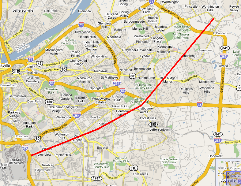
Narrative: Moved northeast from the east edge of Louisville to near Pewee Valley. At least a dozen homes were destroyed. An injured person at Pewee Valley may have died several weeks later. This tornado was probably spawned from the same thunderstorm that produced the earlier tornado in southwest Louisville (see previous entry). It appears to have touched down at Hike's Point along Taylorsville Road and Brown's Lane. Barns and outhouses were levelled, roofs were blown off, and a car was overturned. The tornado moved to the northeast through present-day Saint Regis Park and Hurstbourbne. The twister may have lifted briefly as it crossed Shelbyville Road very near Eight Mile House (which was unaffected). The tornado caused intermittent damage through Anchorage, and then grew in intensity and remained on the ground from O'Bannon into Pewee Valley. The twister was 1/4 mile wide as it entered Pewee Valley where it destroyed a three-story brick home and a two-story frame house. A two-story house in Pewee Valley was swept ten feet off its foundation and collapsed. Trees blocked the Louisville-Pewee Valley road for two miles. Immediately after the storm, Lagrange Interurban cars leaving Louisville could not get beyond Lyndon. Two days after the tornado the tracks were still blocked beginning at O'Bannon Station. Hail up to 2 1/4 inches in diameter pounded Crescent Hill, and the stones had large "horns" on them.
January 19, 1928
Counties: Jefferson KY
F-scale: F2
Deaths: 0
Injuries: 17
Path width: 50 yards
Path length: 16 miles
Time: 7:20am
Narrative: This unusual January tornado touched down southwest of Shively and moved east-northeast. The tornado lifted near Anchorage after cutting a narrow path through the south suburbs of Louisville. About a hundred homes were unroofed or damaged. The first damage was to a farm on Lower Hunters Trace Road. The tornado quickly strengthened and caused quite a bit of damage in Saint Helens, just southwest of Shively. Damage was reported at Rockford Station (Rockford Lane and 18th Street Road -- now Dixie Highway). On Stewart Avenue a house lost its roof. The tornado then weakened or possibly lifted as it passed through or over Jacobs, where little damage occurred. The tornado then touched back down or strengthened as it entered Wyandotte-Oakdale. Damage was widespread along Dresden and Longfield Avenues, with damage on Longfield reported at the addresses of 812, 713, 716, and at 715 the house was "twisted." A house lost its roof at 570 Dresden Avenue, with additional damage at 550 and 552 Dresden. The tornado proceeded to the northeast across the southeastern section of Churchill Downs -- click here to see a map of how close the tornado came to the twin spires (the path of the tornado is outlined by the thick white lines). The tornado's worst damage then occurred in the 3800 block of Southern Parkway, with walls blown out of homes at the addresses of 3833, 3831, 3855, 3844, 3848, and 3850. Three brick houses were completely wrecked. The last significant damage occurred on High Street near Boxley Avenue where a house was unroofed and several cottages were damaged. Damage between this location (just east of Cardinal Stadium) and Anchorage was very light and spotty. J. L. Kendall and Grady Norton, meteorologists with the Weather Bureau, surveyed that damage and called the event, "a true tornado."
January 19, 1928
Counties: Jefferson KY
F-scale: F2
Deaths: 0
Injuries: 0
Path width: 50 yards
Path length: 4 miles
Time: 7:20am
Narrative: This tornado moved east-northeast from one mile northwest of Fern Creek, traveling parallel to the previously mentioned tornado. One barn was destroyed, and others were damaged.
March 25, 1964
Counties: Jefferson KY, Shelby, Oldham, Henry
F-scale: F2
Deaths: 0
Injuries: 1
Path width: 30 yards
Path length:
Time: 7:00pm
Grazulis narrative: Skipped east-northeast from just east of Standiford Field to Smithfield and New Castle. The "bounding" tornado, and accompanying high winds, unroofed or damaged four homes, 31 barns, and fifty other buildings.
Jefferson County: The Jefferson County portion of the track was well-covered in the local newspapers. The tornado touched down on the east side of Louisville International Airport at the intersection of Standiford Lane and Preston Highway, where it lifted and blew a car 40 feet, depositing it on its roof. The tornado grew to about two blocks wide and tore the roof off of a home at 4503 Zeta Court, dropping it in the back yard. Also on Zeta Court a car was flipped over. At about the same time a truck was flipped over at 2420 Cavelle Avenue. The tornado may have weakened or lifted slightly as the storm moved through Watterson Park and West Buechel. Damage then occurred again when a frame home's garage was torn from its foundation at 2835 Klondike Lane and was thrown 100 feet into the side of Saint Martha Catholic Church. On Dale Ann Drive a playhouse weighing 1500 pounds was blown 200 feet. After causing comparatively little damage in Houston Acres, the tornado strengthened again and grew to a width of about three blocks. On Cardwell Way a carport collapsed, three homes were damaged, and a car was demolished. Meanwhile, siding was removed from a home at 58 Hallsdale Drive and a garage was destroyed next door at 60 Hallsdale Drive. The tornado may have again weakened or lifted as the storm crossed Blue Ridge Manor and Anchorage. The last damage report in Jefferson County was on Collins Lane where homes and commercial buildings were damaged, and roofs were removed from barns. The head of the weather service office in Louisville, O. K. Anderson, surveyed the damage and said there was no doubt in his mind that it was a small, bounding tornado. Click here for a map of the Jefferson County portion of this tornado track. Louisville newspapers did not mention any damage in Oldham or Shelby Counties. There was mention of tornado damage in Smithfield and just outside New Castle in Henry County.
Noted discrepancies: Grazulis does not include Shelby County. NCDC does not list Oldham County or Henry County, and lists Jefferson County twice. Storm Data lists only Jefferson and Henry counties. SPC, Storm Data, and NCDC give a time of 7:00pm, Grazulis give 7:25pm. SPC gives and endpoint lat/lon of 28.50/-85.12...NCDC give 38.22/-85.45. SPC, Storm Data, and NCDC list one injury...Grazulis lists none. SPC gives a path length of 38 miles, NCDC gives 33 miles, Storm Data says 40 miles, Grazulis lists a skipping path of 23 miles. SPC gives a path width of 10 yards, NCDC 30 yards, Grazulis 40 yards. The second of the two Jefferson County entries at NCDC lists the touchdown point with the exact same lat/lon as the liftoff point in the first Jefferson County entry. Grazulis does mention that the tornado skipped. The NCDC touchdown lat/lon in Shelby County is not the same as the liftoff lat/lon in Jefferson County, though it ought to be if the tornado went directly from Jefferson County into Shelby County as one coherent tornado, so perhaps at the NCDC website the Shelby County event is a separate tornado, and is also a separate tornado according to Grazulis who perhaps felt it was not F2 and thus omitted it...? Grazulis takes the twister from Jefferson County into Oldham County (instead of Shelby County) and on into Henry County (agreeing with SPC's database). The touchdown and liftoff lat/lon given by SPC/NCDC agree perfectly with Grazulis. Using the touchdown and liftoff lat/lons at SPC, this tornado would have missed Shelby County. The end lat/lon given by NCDC for Shelby County is actually located in Henry County. Storm Data narrative says, "A small tornado of the bounding type moved in a straight line west-southwest to east-northeast from about half a mile east of Standiford Field...to approximately ten miles northeast. Apparently the same tornado continued northeastward into Henry County. It touched down several times in Jefferson County, and in Henry County...in the vicinities of Smithfield and New Castle." More research is necessary.
April 1, 1970
Counties: Jefferson KY
F-scale: F1
Deaths: 0
Injuries: 0
Path width:
Path length: 2.8 miles
Time: 8:00pm
Notes: (Taken from an internal Weather Bureau memo) A roof was severely damaged in Plantation on Hermitage Way. Many trees were uprooted and there were signs of rotation on Goose Creek Road. At 4022 Simcoe Road a barn was overturned, killing a horse inside, and 100 yards of plank fence were demolished. At 4510 Chamberlain Lane on the J. W. Head farm the roof of the residence was destroyed, portions of which were found several hundred yards downstream. Most of the roof was lifted up and over power lines that were 20 feet above the ground 150 feet distant from the house. A store at the intersection of Brownsboro Road and Ballardsville Road was unroofed. Outside of these points, weak trees were felled, signs were blown over, and minor roof damage occurred.
Notes: Storm Data says this tornado touched down eleven miles northeast of Standiford Field and traveled northeast for three miles.
April 3, 1974
Counties: Jefferson KY, Oldham
F-scale: F4
Deaths:
Injuries:
Path width: 200 yards
Path length:
Time: 3:37pm
Grazulis narrative: Moved northeast from the Kentucky State Fairgrounds in Louisville. Dozens of buildings and hundreds of trees were destroyed in Louisville. About a dozen expensive homes were destroyed in affluent suburbs of northeast Louisville. About 425 homes were destroyed in Jefferson County, and 25 were damaged in Oldham County. Losses on one Oldham County farm amounted to $200,000.
Noted discrepancies: SPC and NCDC list three fatalities, Grazulis 2, Storm Data 6. SPC and NCDC list 225 injuries, Grazulis lists 228, Storm Data 243. SPC lists a path length of 19 miles, NCDC 18 miles, Grazulis 21 miles. SPC lists a path width of 10 yards (obviously incorrect), NCDC 30 yards (obviously incorrect), and Grazulis 200 yards.
May 29, 1974
Counties: Jefferson KY
F-scale: F1
Deaths:
Injuries:
Path width:
Path length:
Time: 10:28pm
Noted discrepancies: None
June 30, 1977
Counties: Jefferson KY
F-scale: F0
Deaths:
Injuries:
Path width:
Path length:
Time: 6:30pm
Notes: Storm Data says this tornado struck Valley Station.
May 28, 1996
Counties: Jefferson KY, Bullitt, Spencer
F-scale: F4
Deaths:
Injuries: 10
Path width:
Path length:
Time: 4:40pm
Noted discrepancies: NCDC narrative does not match up with the lat/lons given for Jefferson County.
Notes: Storm Data says this tornado formed four miles northwest of Brooks...hit Holsclaw Hill Road...Top Hill Road...near the I-65 Brooks exit...Pioneer Village...Hillview...the Northfield subdivision in Mount Washington...crossed KY 55...passed one and a half miles south of Taylorsville...near Taylorsville Lake Dam...ending just east of Little Mount.
July 27, 1997
Counties: Jefferson KY
F-scale: F0
Deaths:
Injuries:
Path width:
Path length: 1/2 mile
Time: 7:05pm
Noted discrepancies: SPC's lat/lon do not agree with NCDC's narrative. Plotted according to NCDC's narrative. Storm Data says this tornado touched down just south of the Gene Snyder Freeway two miles south-southeast of Jeffersontown.
October 4, 2002
Counties: Jefferson KY
F-scale: F1
Deaths:
Injuries:
Path width: 50 yards
Path length:
Time: 5:47pm
Noted discrepancies: SPC lists a path width of 17 yards, NCDC and Storm Data say 50 yards.
Notes: Storm Data says this tornado touched down on the Ohio River 8.4 miles northeast of Louisville, moved through the Springhurst area of Louisville, struck the Indian Springs Country Club, and lifted 12.6 miles northeast of Louisville. Wonder if this formed in the remnants of Hurricane Lili?
May 30, 2004
Counties: Jefferson KY
F-scale: F0
Deaths:
Injuries:
Path width:
Path length:
Time: 4:27pm
Notes: Storm Data says this tornado touched down just east of Bardstown Road near the entrance to the Glenmary Subdivision and lifted on the far side of the subdivision.
April 22, 2005
Counties: Jefferson KY
F-scale: F0
Deaths: 0
Injuries: 0
Path width: 50 yards
Path length:
Time: 5:47pm
Notes: The tornado touched down near the intersection of Campbell and Market streets, where the roof on a business was destroyed, and a telephone pole was snapped. An empty trailer was flipped over near this location. The Stockyard Farm Supply Company on South Johnson Street sustained roof damage.
January 2, 2006
Counties: Jefferson KY
F-scale: F1
Deaths: 0
Injuries: 0
Path width: 34 yards
Path length: 2 miles
Time: 3:22pm
Notes: A tornado touched down near the corner of Bramers and Campground roads. Many homes along the damage path had roof damage. A large, well constructed barn was destroyed. Numerous trees and power lines were downed, and one tree was blown onto a house. The local Moose Lodge building had significant damage. The tornado lifted around 3:27pm near the intersection of Campground Road and Ralph Avenue.
October 18, 2007
Counties: Jefferson, KY
EF-scale: EF0
Deaths: 0
Injuries: 0
Path width: 75 yards
Path length: Less than 440 yards
Time: 7:10pm EDT to 7:11pm EDT
Notes: Touched down at the Kroger's store at 2200 Brownsboro Road. Windows were blown out, a cart corral was blown into a vehicle, and a power pole was blown down.
January 29, 2008
Counties: Jefferson, KY
EF-scale: EF1
Deaths: 0
Injuries: 0
Path width: 100 yards
Path length: 16.4 miles
Time: 8:00pm EST to 8:13pm EST
Notes: A fast moving tornado briefly touched down four times in Louisville. The tornado was on the ground for about one and a half miles over the course of its 16 mile long skipping track. The first touchdown was in an industrial area just off Millers Lane west of Dixie Highway. The tornado stayed on the ground for one mile before lifting, heavily damaging a church on Dixie Highway, as well as uprooting and snapping several trees and damaging numerous homes. The tornado then dipped to earth again on the west side of the University of Louisville campus, breaking out many windows in a large residence hall and nearby building, and damaging several vehicles parked nearby. The next touchdown happened in Saint Matthews near the intersection of Shelbyville Road and Interstate 264, where extensive damage was suffered by many businesses and private properties. The fourth and final touchdown was in Anchorage where many trees were damaged, blown over, and uprooted, roofs were damaged, and a large outbuilding at a training school was destroyed.
February 28, 2011
Counties: Clark IN, Jefferson KY
F-scale: EF1
Deaths: 0
Injuries: 0
Path width: 100 yards
Path length: 3 miles
Time: 4:31am EST
Notes: This tornado touched down near Centennial Boulevard in Clark County. Large hardwood trees were uprooted along the tornado's path towards Utica. A house on Middle Road had a tin roof blown off and thrown 200 yards. A couple of garage doors were dented in. The tornado then crossed the Ohio River and moved into Harrods Creek. Numerous large hardwood trees were snapped in half. A section of roof was blown off a house. The tornado lifted just west of US 42.
June 22, 2011
Counties: Jefferson KY
EF-Scale: EF-2
Deaths: 0
Injuries: 0
Path width: 120 yards
Path length: 1.2 mile
Time: 8:04pm EDT
Notes: This tornado touched down at Churchill Downs with EF-1 strength and wind speeds of up to 105 mph. Five barns at the race track had large sections of their roofs blown off and cinder block walls buckled or collapsed. Christ Church on Churchill Downs had some roof and siding damage. As the tornado moved east it strengthened to EF-2 intensity near the intersection of Floyd Street and Central Avenue where a large industrial building was heavily damaged. Numerous trees were uprooted and snapped along the storm's path. Near the intersection of Crittenden Drive and Central Avenue a Super 8 Motel had minor roof damage.
June 22, 2011
Counties: Jefferson KY
EF-Scale: EF-1
Deaths: 0
Injuries: 0
Path width: 150 yards
Path length: 1.9 mile
Time: 9:29pm EDT
Notes: At the start of the path the tornado was EF-0 strength as it damaged shingles and siding and snapped maple trees. At Orchard Lake Boulevard and Fallen Apple Lane trees were blown down and laid out in north, northeast, and south directions. The tornado moved into the Hurstbourne Woods subdivision and ripped a locked pool gate free and threw it over a building and 35 yards downwind. This location suffered the worst damage with gutters, siding, and soffits ripped from buildings and deposited 30 yards away in trees. Next a large oak tree was uprooted at 3705 Modesto Road and a trampoline was thrown into a Volkswagen and then over a house. At 9407 Willowwood Way there was roof damage and many trees, both hardwood and softwood, were snapped and uprooted. The tornado briefly made about a 25 degree turn to the northeast just before dissipating and causing some roof damage and tree damage at its end point.
June 22, 2011
Counties: Jefferson KY
EF-Scale: EF-2
Deaths: 0
Injuries: 0
Path width: 100 yards
Path length: 1.6 mile
Time: 9:34pm EDT
Notes: This tornado began just east of the end of the previous tornado and began by damaging roofs of about a dozen houses and uprooting and snapping trees along Saint Edwards Drive. Damage was also observed along Charlane Parkway and Dell Road. At the corner of Maple Road and Galene Drive a significant portion of a large oak tree split off and was thrust into a wall of Tully School. There was also structural damage and roof damage at the Good Samaritan Society Nursing Home at 3500 Good Samaritan Way. Two vehicles in the parking lot were thrown about 20 yards and flipped over. Low end EF-2 damage was observed. The storm continued to the east and apparently lifted off the ground as the ground surface descended into a small valley along Ruckriegel Parkway and Chenoweth Run. The tornado again caused damage on Electron Drive at the Dillard's Warehouse and Machinery Specialties Warehouse. At those locations the brick facade of each building was pushed out. A large fence around the Dillard's Warehouse was damaged and a security shack was thrown about 30 yards. The tornado lifted on the south side of Electron Drive.
June 22, 2011
Counties: Jefferson KY
EF-Scale: EF-1
Deaths: 0
Injuries: 0
Path width: 60 yards
Path length: 3.5 mile (skipping)
Time: 9:38pm EDT
Notes: The tornado touched down on the north side of Electron Drive at Ampere Drive just to the northeast of the end point of the previous tornado. An air handler was blown off of the roof of JCK Enterprises and thrown 125 yards. Farther east on Electron Drive several corporations and warehouses had structural damage to roofs and the sides of buildings. The most significant damage was at Oxmoor Collision Center where there was structural damage to some steel framing and stucco. RBI Corporation, next door, also had some structural damage. More than a dozen uprooted and snapped trees were observed around the Tucker House Bed and Breakfast at 2406 Tucker Station Road. The rope-like tornado lifted between Tucker Station Road and Interstate 265. However, the tornado touched back down again just on the other side of the interstate at 1600 South English Station Road as an EF-0. At this location damage included five trees blown down including a 60-foot tall sycamore, shingle damage to a house, a damaged satellite dish, and a destroyed pergola.
January 17, 2012
Counties: Jefferson KY, Oldham
EF-Scale: EF1
Deaths: 0
Injuries: 1
Path width: 250 yards
Path length: 8.2 miles
Time: 11:12am EST
Notes: The tornado touched down near the intersection of I-264 and Brownsboro Road. The tornado tracked northeast to near the intersection of Hurstbourne Lane and Brownsboro Road where it briefly lifted. The tornado then reformed and crossed I-265 and continued to the east-northeast through several subdivisions north and northeast of Fincastle. The tornado crossed into Oldham County, moving through Orchard Grass Hills and lifting at the northern tip of Clore Lane. Damage indicators along the path of this tornado included multiple softwood trees down, minor shingle damage to homes, a side wall downed in a large indoor tennis facility, and a barn roof collapse. An injury occurred as the tornado crossed I-265 when two semi trailers were blown over. The driver of one of the trucks was injured.
January 17, 2012
County: Jefferson KY
EF-Scale: EF-1
Deaths: 0
Injuries: 0
Path width: 90 yards
Path length: 0.2 mile
Time: 11:20am EST
Notes: An EF-1 tornado touched down just to the north of the intersection of Stony Brook Drive and Hurstbourne Parkway. The tornado traveled north-northeast along Stony Brook Drive and lifted near the intersection of Stony Brook and Laverne Drive. Numerous trees were snapped along the path. Siding and shingles were blown off of multiple houses. On Michael Edward Drive the garage door was blown in on a detached garage and the roof was lifted off and shifted a foot.
March 23, 2012
County: Jefferson, KY
EF-Scale: EF-1
Deaths: 0
Injuries: 0
Path width: 70 yards
Path length: 2.5 miles
Time: 2:07pm EDT
Notes: This tornado touched down just north of the intersection of Cedar Creek Road and Mount Washington Road, and lifted just northeast of the intersection of Cedar Creek Road and Long Rifle Lane. The most significant damage was done on Brook Chase Court, about in the middle pf the path.
January 30, 2013
County: Harrison IN, Jefferson KY
EF-Scale: EF0
Deaths: 0
Injuries: 0
Path width: 325 yards
Path length: 2.8 miles
Time: 4:17am EST
Notes: An NWS survey team has confirmed an EF-0 tornado touch down east of Elizabeth in Harrison County, Indiana. Four homes and two barns were damaged along Highway 111. The porch of one home was lifted and thrown 30 feet. The walls of one of the barns collapsed in multiple directions. Trees were down in this location as well. The track of the tornado extended to the Ohio River and into Jefferson County, Kentucky. Northwest of Valley Station many softwood trees were damaged, a pine tree was snapped, and a trampoline was blown over.
June 26, 2018
County: Jefferson KY, Oldham
EF-Scale: EF1
Deaths: 0
Injuries: 0
Path width: 150 yards
Path length: 3.5 miles
Time: 1:44pm - 1:46pm EDT
Notes: This tornado touched down at the entrance of Westport Woods Apartments. Across from the complex numerous trees were snapped or topped off. On Pacelli Place parts of trees were thrown into two houses, puncturing the siding. Most of the damage was high end EF0 around 85 mph with much of the damage being 20 to 50 yards off the ground. There were some hardwood trees uprooted and parts of them fell onto homes, fences, trampolines, and swing sets. Besides trees being twisted and turned in multiple directions, there was leaf and mud spattering on several homes in opposite directions of the storm movement. Intermittent tree top damage continued near Lake Louisvilla. At Westport Business Center there was significant roof damage with portions of the roofing material and parts of the roof supports 20 to 50 yards downwind and several windows blown out. At Ceva Logistics a large section of the north wall was pushed out due to 75-80mph winds. The tornado struck the north portion of Westport Bend Commerce Park, snapping and bending several trees. The tornado began to skip and struck a few trees in Forest Springs North before moving into Oldham County. The tornado lifted briefly before dropping back down on the east side of Pewee Valley near Five Forks Drive. Near Manassas Drive a trampoline was thrown 60 yards and a large sycamore tree was uprooted next to an air conditioner that was thrown to the north. The tornado then increased in strength and uprooted several trees along Hawley Gibson Road. One resident lost twenty softwood and hardwood trees, The tornado lifted just east of Hawley Gibson Road, twisting several trees on a farm there.


 Weather Story
 Weather Map
 Local Radar
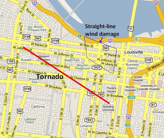