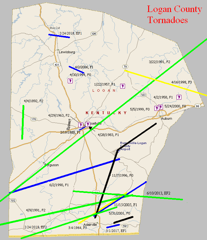
February 19, 1888
Counties: Logan
F-scale: F1
Deaths:
Injuries:
Path width: 100 yards
Path length: 1 mile
Time: 8:30pm (approx.)
Notes: Houses were twisted and trees uprooted. Part of a large outbreak across Missouri, Illinois, Indiana, and Kentucky.
April 4, 1892
Counties: Logan
F-scale: F2
Deaths: 0
Injuries: 15
Path width: 150 yards
Path length: 4 miles
Time: 11:30pm
Narrative: Moved north, passing seven miles west of Russellville. At least five small homes were destroyed. Two people may have died.
January 22, 1957
Counties: Logan
F-scale: F1
Deaths:
Injuries:
Path width:
Path length:
Time: 3:30pm
Noted discrepancies: None.
April 2, 1958
Counties: Logan
F-scale: F1
Deaths:
Injuries: 1
Path width:
Path length:
Time: 2:20pm
Noted discrepancies: SPC gives a path length of 1/10 of a mile...NCDC gives nothing. SPC gives a path width of 10 yards, NCDC gives nothing.
April 29, 1963
Counties: Logan
F-scale: F2
Deaths:
Injuries:
Path width:
Path length:
Time: 8:10pm
Noted discrepancies: SPC and NCDC list this as an F2, Grazulis does not list it. SPC gives a path width of 170 yards and a path length of 9 miles...NCDC gives nothing for either.
Notes: Storm Data says that the central and northern parts of Russellville were hardest hit, including the Kaintuck Hotel.
March 4, 1964
Counties: Logan
F-scale: F3
Deaths: 0
Injuries: 5
Path width: 880 yards
Path length: 7 miles
Time: 2:25pm
Grazulis narrative: Moved northeast from two miles west of Adairville to Schochoh. A home was unroofed and tenant homes and barns were destroyed. Livestock was killed and cars and farm machinery were destroyed.
Noted discrepancies: SPC and NCDC gave this an F3, Grazulis gives an F2. SPC and NCDC give a path length of 7 miles, Grazulis and Storm Data give 8 miles. SPC, Storm Data, and NCDC give a path width of 880 yards, Grazulis gives 800 yards. The touchdown lat/lon listed by NCDC and SPC is in Hickman County, and the liftoff lat/lon is in Graves County (far western Kentucky). Grazulis takes the tornado from two miles west of Adairville to Schochoh, which agrees with Storm Data.
April 28, 1983
Counties: Logan
F-scale: F1
Deaths:
Injuries:
Path width:
Path length:
Time: 8:47pm
Noted discrepancies: None
June 2, 1990
Counties: Logan
F-scale: F1
Deaths:
Injuries:
Path width:
Path length:
Time: 10:34pm
Notes: Storm Data says this tornado moved from Allensville (which is actually in Todd County, but is very close to the Logan County line) to Corinth.
March 22, 1991
Counties: Logan, Warren (from Todd)
F-scale: F2
Deaths: 1
Injuries: 12
Path width: 400 yards
Path length:
Time: 5:50pm
Grazulis narrative: Skipped northeast from 6 1/2 miles southeast of Trenton to southwest of Allensville to near Lickskillet to near Auburn and Richardsville. Southeast of Trenton the tornado was on the ground for a mile and a half and destroyed a barn and a trailer. Twelve homes were destroyed in the touchdown near Allensville. Churches and a tied-down trailer were destroyed near Lickskillet. An 11-year-old boy was killed in the trailer. Several barns were destroyed farther to the northeast.
Noted discrepancies: SPC and NCDC give a path length of 39 miles, Grazulis gives 45 miles, and Storm Data says 25 miles.
April 9, 1991
Counties: Logan (from Todd)
F-scale: F2
Deaths: 0
Injuries: 0
Path width: 75 yards
Path length: 21 miles
Time: 11:50
Grazulis narrative: Skipped from Guthrie to Keysburg and Schochoh. Trees were uprooted. Mobile homes and outbuildings were damaged.
Noted discrepancies: NWS calls this an F2, Grazulis says F1.
April 30, 1994
Counties: Logan
F-scale: F0
Deaths:
Injuries:
Path width:
Path length:
Time: 7:17pm
Noted discrepancies: Not listed at NCDC.
November 7, 1996
Counties: Logan
F-scale: F0
Deaths: 0
Injuries: 0
Path width: 30 yards
Path length: 10 miles (skipping)
Time: 12:35pm
Notes: This small tornado did $500,000 damage to planes at Logan County Airport. Five planes were destroyed.
April 16, 1998
Counties: Logan, Warren, Allen, Barren
F-scale: F3
Deaths: 2
Injuries: 9
Path width:
Path length: 58 miles
Time: 2:35pm
Notes: After researching this tornado (see discrepancies below), including reviewing radar data, it appears this tornado touched down at Chandlers Chapel in northeast Logan County, moving through Warren County crossing I-65 about seven and a half miles south of Bowling Green, continuing eastward into northernmost Allen County passing just north of Meador, then turning to the northeast near Finny, Haywood, three miles south of Glasgow, and ending at the Metcalfe County line near where the parkway crosses the border. The worst damage was in Barren County. Homes on Needmore School Road southwest of Haywood were extensively damaged, and a mobile home was flipped over near the intersection of Riddle Road and KY 249. In Glasgow one person was killed in his mobile home and another was killed by flying debris. In the Glasgow area one house was destroyed (F3 damage) and 45 badly damaged. Winds estimated at 175mph near Glasgow damaged or destroyed 35 mobile homes and 25 barns.
Noted discrepancies: SPC mistakenly replaces Warren County with Lawrence County. SPC gives a beginning latitude of 36.92...NCDC gives 36.95. SPC gives a path width of 100 yards, NCDC gives 200 yards. The lat/lons given for this event are all over the place. Going by the beginning lat/lon in Logan County and the ending lat/lon in Barren County, the track would go through the south side of Glasgow and would end at the Barren/Metcalfe county line, which agrees with the narrative given at NCDC. However, this path would completely miss Allen County. Storm Data has it in Logan County (Chandlers Chapel to six miles east of Chandlers Chapel), Warren County (ten miles southwest of Bowling Green to sixteen miles southeast of Bowling Green), Allen County (three miles west of Meador to two miles east of Meador), and Barren County (fourteen miles southwest of Glasgow to ten miles east of Glasgow, with Glasgow hard hit).
May 5, 1999
Counties: Logan
F-scale: F0
Deaths:
Injuries:
Path width:
Path length:
Time: 10:30pm
Notes: Storm Data says this tornado touched down in a field along KY 103 a mile north of Auburn.
May 24, 2000
Counties: Logan
F-scale: F0
Deaths:
Injuries:
Path width:
Path length:
Time: 4:24pm
Notes: Storm Data says this tornado touched down on Liberty Church Road in Auburn.
May 31, 2001
Counties: Logan
F-scale: F0
Deaths:
Injuries:
Path width: 50 yards
Path length:
Time: 6:30pm
Noted discrepancies: SPC lists a path width of 17 yards, NCDC and Storm Data list 50 yards.
Notes: Storm Data says this tornado touched down two miles east of Adairsville and moved northeast for two miles.
November 15, 2005
Counties: Logan
F-scale: F1
Deaths: 0
Injuries: 0
Path width: 150 yards
Path length: 8 miles
Time: 5:36pm
Notes: This tornado touched down just north of Adairville. Many homes, trailers, outbuildings, and barns were damaged along the tornado's intermittent path. The tornado lifted near the Simpson County line near KY 100.
April 2, 2006
Counties: Logan
F-scale: F1
Deaths: 0
Injuries: 0
Path width: 100 yards
Path length: 2 miles
Time: 10:30pm Central time
Notes: Intermittent track.
June 10, 2013
Counties: Logan and Simpson
EF-Scale: EF2
Deaths: 0
Injuries: 4
Path width: 325 yards
Path length: 14 miles
Time: 1:40pm CDT
Notes: Touchdown occurred northwest of Adairville near the intersection of Vick Road and Route 96, where a barn sustained roof damage and another outbuilding was destroyed. EF2 damage occurred sporadically from near Route 96 to the Logan/Simpson county line. The worst damage occurred north-northeast of Adairsville where the tornado crossed Route 663. Several homes sustained extensive damage and three people were injured. A fourth person was injured on Trimble Road. The tornado entered Simpson County just north of the intersection of Conn Road and Reames Dixon Road. The tornado produced EF1 and EF0 damage in Simpson County until it lifted at Russellville-Gallatin Road at 2:09pm CDT. A total of five homes sustained extensive damage, and two homes suffered minor damage. Five grain bins were blown away, and two others collapsed. Numerous outbuildings were damaged or destroyed.
March 1, 2017
County: Logan
EF-Scale: EF1
Deaths: 0
Injuries: 0
Path width: 75 yards
Path length: 1.6 miles
Time: 6:57am - 6:59am CST
Notes: This tornado touched down southeast of Adairville and lifted 2.5 miles east of Adairville. The tornado did minor roof damage to a house near Martin Road. A home and an outbuilding had minor damage near Barnes Road, along with several downed trees. The most significant damage occurred near the end of the path near Prices Mill Road where a large barn lost a significant portion of its roof. Maximum wind speeds were 95 mph.
February 24, 2018
County: Logan (from Robertson, Tennessee)
EF-Scale: EF2
Deaths: 1
Injuries: 1
Path width: 350 yards
Path length: 11.6 miles
Time: 3:54pm - 4:12pm CST
Notes: The tornado began at the end of McGee Road where two homes suffered extensive damage. The first home, a well built stone home, had significant roof damage and the screened-in porch was destroyed. The family's pick-up truck was thrown 40 yards to the north. On the family's cemetery, several tombstones were knocked over and one headstone was destroyed. There were several outbuildings and two pole barns destroyed as well. The second home experienced significant foundation damage and the roof was completely removed. A pick-up truck was thrown 250 yards into a field. Insulation from the home was found 300 yards away. The debris field from the two homes extended into a farmer's field up to a quarter mile downwind with several boards and bricks thrust into the ground. The tornado continued through several fields doing extensive tree and fence damage. Power lines were torn down. The tornado destroyed two barns at 901 Dot Road, where it also moved heavy farm equipment, blew out exterior walls, and destroyed the home's roof. Falling debris at this location struck and killed a resident. The family dog was found alive under piles of rubble. Debris was thrown 500 yards away. The tornado then hit a large farm at 3604 Schley Road destroying the second story of the home. The family was out to eat at the time, but had they been home the children would have been napping at the time the tornado struck. Three empty silos were destroyed with metal sheets thrown a quarter of a mile. The tornado continued along through fields, damaging and uprooting trees. At the intersection of Mortimer Station Road and Marriah Church Road trees were snapped and several homes experienced shingle, siding, and roof damage. Trees were snapped in Schochoh as the tornado lifted.
February 24, 2018
County: Logan
EF-Scale: EF1
Deaths: 0
Injuries: 0
Path width: 300 yards
Path length: 2.9 miles
Time: 9:15pm - 9:16pm CST
Notes: The first damage occurred off of Old Greenville Road where several homes experienced siding and roof damage. There were some snapped cedar trees and a couple of uprooted trees and one resident at the end of the road saw their home's windows moving back and forth and their ears popped as they headed to the basement. There was extensive tree damage along Elamond Road where over 100 trees were snapped, twisted, and uprooted. At 291 Elamond Road part of the roof of a home was peeled back with extensive siding damage.


 Weather Story
 Weather Map
 Local Radar