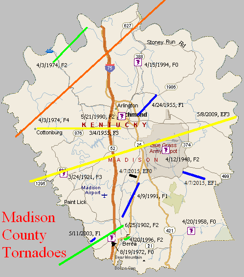
June 25, 1902
Counties: Garrard, Madison
F-scale: F2
Deaths: 4
Injuries: 25
Path width:
Path length: 9 miles
Time: 10:00pm
Narrative: Moved northeast from near Cartersville to north of Berea. An elderly man and a child were killed in a home two miles west of Berea. Two other people died in Garrard County near Cartersville. At least 15 homes were destroyed or torn apart.
March 24, 1921
Counties: Madison
F-scale: F3
Deaths: 0
Injuries: 5
Path width:
Path length:
Time:
Narrative: This tornado hit the Kirksville and Silver Creek areas. Debris from one home blocked the railroad tracks for three hours. Two people received injuries when a chimney fell on them and broke their ribs. Several houses were reduced to kindling, and one tenant house was "blown completely away" near Silver Creek. One boy received a broken leg. Warwick Distillery at Silver Creek lost its roof. Near Kirksville one home was demolished and another lost its roof. A parlor rug from the house that lost its roof was later found in Phil Arbuckle's pasture, torn to rags, a mile away. One farmer witnessed a "funnel shaped cloud accompanied by a roar" like a truck at Silver Creek.
April 12, 1948
Counties: Madison
F-scale: F2
Deaths: 0
Injuries: 0
Path width:
Path length:
Time: 4:45am
Narrative: Large buildings were destroyed at the Bluegrass Ordnance Depot at Richmond.
March 4, 1955
Counties: Madison
F-scale: F3
Deaths: 0
Injuries: 2
Path width: 250 yards
Path length: 5 miles
Time: 6:45pm
Grazulis Narrative: Moved east from Cottonburg to south of Richmond. Two homes and several barns were destroyed. Ten cows were killed.
Noted discrepancies: SPC and NCDC call this an F3, Grazulis calls it an F2. SPC and NCDC give it a path length of 9 miles, Grazulis and Storm Data give a length of 5 miles. SPC gives a path width of 10 yards, NCDC 30 yards, and Grazulis and Storm Data 250 yards. (Grazulis and Storm Data list the touchdown at "Cottonwood", by which they probably mean "Cottonburg", which is west of Richmond two miles east of the Garrard County line.)
April 24, 1955
Counties: Madison
F-scale: F1
Deaths: 0
Injuries: 2
Path width: 800 yards
Path length: 3 miles
Time: 3:45am
Grazulis Narrative: Moved northeast near Eastern State College in Richmond. Homes were unroofed in the student housing area. Hundreds of trees were uprooted.
Noted discrepancies: Grazulis lists this tornado as having occurred at 3:00am...Storm Data lists it at 3:45am...SPC lists it at 3:45pm. Storm Data also mentions it lifted at 4:00am. Would tend to believe Storm Data here. Storm Data says most damage was in and around Eastern State College in Richmond. Grazulis lists this tornado as an F2.
April 20, 1958
Counties: Madison
F-scale: F1
Deaths:
Injuries:
Path width:
Path length:
Time: 4:30pm
Noted discrepancies: SPC gives a path length of 1/10 of a mile...NCDC gives nothing. SPC gives a path width of 10 yards, NCDC gives nothing.
June 6, 1966
Counties: Madison
F-scale: F2
Deaths:
Injuries:
Path width:
Path length:
Time: Noon
Noted discrepancies: SPC has this storm moving from McCracken County directly into Madison County, which is geographically impossible. At NCDC the two counties are listed separately. SPC list this event as an F2...Grazulis does not list it.
Notes: SPC's touchdown lat/lon is in McCracken County, and the liftoff lat/lon is in Marshall County. At NCDC's listing for Madison County, the touchdown lat/lon is in Marshall County (near the McCracken County line) and the liftoff lat/lon is in Marshall County (same as SPC). Storm Data lists this tornado in McCracken and Marshall counties. It appears this tornado should be listed as Marshall/McCracken rather than McCracken/Madison. More research would be nice.
August 19, 1972
Counties: Madison
F-scale: F2
Deaths:
Injuries: 1
Path width:
Path length:
Time: 2:00pm
Noted discrepancies: NWS lists this as an F2, Grazulis does not list it. SPC gives a path length of 1/10 of a mile and a path width of 10 yards...NCDC gives nothing for either.
April 3, 1974
Counties: Garrard, Madison, Clark KY
F-scale: F4
Deaths: 7
Injuries:
Path width: 300 yards
Path length:
Time: 6:20pm
Grazulis narrative: Moved northeast from near Hackley and Cottonburg, passing just north of Richmond, and lifting east of Mount Sterling. Thirty homes were destroyed, with F4 damage and deaths in southwest Madison County, mostly near Richmond. About 100 people were left homeless in Clark County.
Noted discrepancies: SPC, Storm Data, and NCDC give 28 injuries, Grazulis give 27. SPC and NCDC give a path length of 32 miles, Grazulis give 35 miles, Storm Data 22 miles. SPC gives a path width of 10 yards, NCDC 30 yards, Storm Data 133 yards, Grazulis 300 yards. Grazulis takes this tornado into Montgomery County, ending it east of Mount Sterling. SPC and NCDC end the tornado in Clark County east of Mount Zion. Grazulis places this tornado at 7:20pm.
Notes: Grazulis' path width is probably the most correct. Storm Data begins this tornado at Cottonburg, moving it to two miles north of Whitehall and beyond. According to the Garrard County weekly Central Herald, there were seven injuries in Garrard County, which are not accounted for at the NCDC webpage (it lists zero injuries for the Garrard County portion of this tornado). Grazulis doesn't many any specific locations of the injuries he reported.
April 3, 1974
Counties: Madison, Fayette
F-scale: F2
Deaths:
Injuries: 0
Path width:
Path length:
Time: 6:30pm
Grazulis narrative: Moved northeast near Valley View, destroying buildings in the southeast part of (Fayette County).
Noted discrepancies: Grazulis does not include Madison County. NCDC does not include Fayette County. NCDC gives no endpoint lat/lon. SPC starts the tornado in Madison County just south of Valley View, which is in Madison County near the point where Madison, Jessamine, and Fayette counties meet (but definitely in Madison County). The way the Kentucky River winds through the area, the SPC track takes the tornado from near Valley View in Madison County, into southernmost Lexington in Fayette County, and then back into Madison County. Storm Data mentions only that this tornado "touched down briefly" near where I-75 crosses the Fayette/Madison County line. SPC and NCDC give a path length of 5 miles, Grazulis gives 9 miles. SPC gives a path width of 10 yards, NCDC 30 yards, Grazulis nothing.
May 21, 1990
Counties: Madison
F-scale: F2
Deaths: 0
Injuries: 1
Path width: 50 yards
Path length: 1/2 mile
Time: 4:45pm
Grazulis narrative: Moved east in Richmond, destroying a barn and a nightclub. A liquor store and two warehouses were unroofed.
Noted discrepancies: None
April 9, 1991
Counties: Madison
F-scale: F1
Deaths:
Injuries:
Path width:
Path length:
Time: 2:00pm
Noted discrepancies: SPC gives a time of 2:00pm, NCDC 1:00pm, Storm Data 3:00pm.
Notes: Storm Data says this tornado touched down just north of Berea, then moved northeast for four miles.
April 15, 1994
Counties: Madison
F-scale: F0
Deaths:
Injuries:
Path width:
Path length:
Time: 11:29am
Noted discrepancies: Not listed at NCDC.
April 20, 1996
Counties: Madison
F-scale: F2
Deaths:
Injuries: 10
Path width:
Path length:
Time: 3:45am
Notes: Storm Data says this tornado touched down on the east side of I-75 at the KY 21 exit. Berea College was damaged.
May 11, 2003
Counties: Madison
F-scale: F1
Deaths:
Injuries:
Path width:
Path length:
Time: 5:56am
Notes: Storm Data places this tornado two and a half miles west southwest of Happy Landing.
May 8, 2009
Counties: Garrard and Madison
EF-scale: EF3
Deaths: 2
Injuries: several, some serious
Path width: 150 yards
Path length: 22 miles
Time: 4:55pm EDT - 5:19pm EDT
Notes: The tornado touched down in eastern Garrard County south of Nina on Bethel Road. The first damage observed was of EF1 intensity, and the tornado grew to EF2 intensity before reaching the Madison County line. The second home in the path of the tornado was badly damaged and a paper bill from the home was lifted into the tornado and carried 35 miles to the northeast into Powell County, landing in the yard of a National Weather Service employee. The tornado peaked at EF3 intensity near the intersections of KY 52 and KY 1295 in Madison County. A mobile home was picked up, thrown, and disintegrated by the tornado. Two adults were killed and thrown into a nearby pond. Five other occupants of the mobile home were injured. One person became paralyzed from the neck down, and a 4 year old child suffered a fractured skull and broken leg. The tornado then weakened and crossed the Blue Grass Army Depot, doing minor damage. The twister finally lifted near the end of Drowning Creek Road northeast of Waco.
April 7, 2015
County: Madison
EF-Scale: EF0
Deaths: 0
Injuries: 0
Path width: 35 yards
Path length: 0.6 mile
Time: 6:57pm - 6:58pm EDT
Notes: The tornado first touched down near a ravine just northwest of Jessica Circle where it snapped a few trees. It then moved southeast, destroying two outbuildings. One of the outbuildings was fully packed, weighing several thousand pounds, and another larger outbuilding was pushed off its foundation. The tornado also did some damage to the roof and shingles of a residence at 326 Jessica Circle. The tornado then continued on an intermittent path to the southeast where it did some additional roof damage to another home and snapped several other trees. The tornado lifted just west of Cherokee Lane.
April 7, 2015
County: Madison
EF-Scale: EF1
Deaths: 0
Injuries: 0
Path width: 215 yards
Path length: 2 miles
Time: 7:03pm - 7:06pm EDT
Notes: The tornado touched down on a farm at 1235 Crooksville Road where it snapped and uprooted several trees, spreading them in several directions. It then continued southeast across Gumbottom Road, where a large oak tree was uprooted. Sporadic tree damage continued southeast towards Walter Lakes Road. Just before the tornado lifted, it did minor shingle and porch damage to a residence along Walter Lakes Road.


 Weather Story
 Weather Map
 Local Radar