
Strong to severe thunderstorms capable of producing large to very large hail, damaging wind gusts and a few strong tornadoes are likely from the Midwest to the Mid-Atlantic tonight. Moderate Risk (level 4 of 5) of severe thunderstorms is outlooked for the Midwest. A widespread heat wave will peak in the South and East on Friday, with many temperature records expected to be broken. Read More >
Louisville, KY
Weather Forecast Office
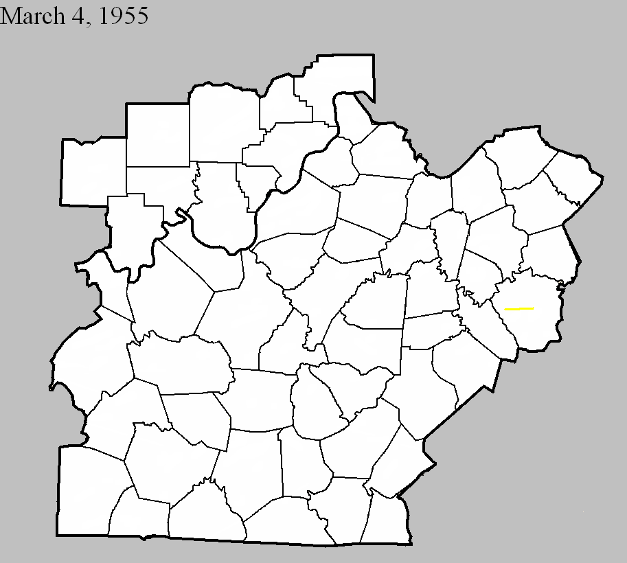
March 4, 1955
Counties: Madison
F-scale: F3
Deaths: 0
Injuries: 2
Path width: 250 yards
Path length: 5 miles
Time: 6:45pm
Grazulis Narrative: Moved east from Cottonburg to south of Richmond. Two homes and several barns were destroyed. Ten cows were killed.
Noted discrepancies: SPC and NCDC call this an F3, Grazulis calls it an F2. SPC and NCDC give it a path length of 9 miles, Grazulis and Storm Data give a length of 5 miles. SPC gives a path width of 10 yards, NCDC 30 yards, and Grazulis and Storm Data 250 yards. (Grazulis and Storm Data list the touchdown at "Cottonwood", by which they probably mean "Cottonburg", which is west of Richmond two miles east of the Garrard County line.)
Current Hazards
Hazardous Weather Outlook
Storm Prediction Center
Submit a Storm Report
Advisory/Warning Criteria
Radar
Fort Knox
Evansville
Fort Campbell
Nashville
Jackson
Wilmington
Latest Forecasts
El Nino and La Nina
Climate Prediction
Central U.S. Weather Stories
1-Stop Winter Forecast
Aviation
IDSS Forecast Points
Air Quality
Fire Weather
Recreation Forecasts
1-Stop Drought
Event Ready
1-Stop Severe Forecast
Past Weather
Climate Graphs
1-Stop Climate
CoCoRaHS
Local Climate Pages
Tornado History
Past Derby/Oaks/Thunder Weather
Football Weather
Local Information
About the NWS
Forecast Discussion
Items of Interest
Spotter Training
Regional Weather Map
Decision Support Page
Text Products
Science and Technology
Outreach
LMK Warning Area
About Our Office
Station History
Hazardous Weather Outlook
Local Climate Page
Tornado Machine Plans
Weather Enterprise Resources
US Dept of Commerce
National Oceanic and Atmospheric Administration
National Weather Service
Louisville, KY
6201 Theiler Lane
Louisville, KY 40229-1476
502-969-8842
Comments? Questions? Please Contact Us.


 Weather Story
 Weather Map
 Local Radar