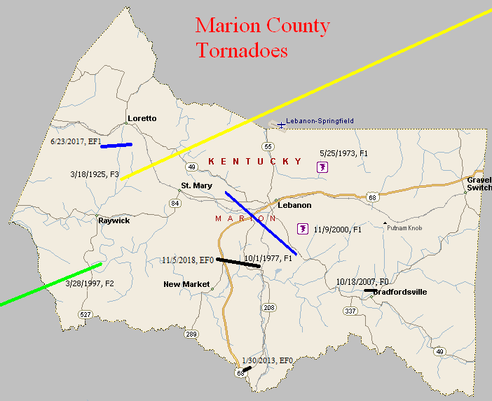
March 18, 1925
Counties: Marion, Washington KY, Mercer, Jessamine, Fayette, Bourbon
F-scale: F3
Deaths: 2
Injuries: 40
Path width: 300 yards
Path length: 60 miles (skipping)
Time: 6:30pm
Notes: What was almost certainly a family of tornadoes moved northeast from western Marion County (according to Grazulis) to 4 miles southwest of Paris in Bourbon County. This project has so far been unable to find any damage in Marion or Jessamine Counties. In Washington County many buildings across the county were leveled. The country home of Judge Case near Springfield was unroofed. The "Negro section" of Jimtown was destroyed, and all 25 houses in Jimtown were razed after the storm. In Springfield 30 people were injured and 2 were killed (the two fatalities may have been from Jimtown). Moving into Mercer County, two barns were lost on the Bond Farm. A barn was damaged and a house unroofed on the Terhune Farm, barns were blown down on the Quartz and Shelton Farms, a house and a barn were lost on the Sanford Farm, and the home of Kye Crossfield at Ebenezer was destroyed. The tornado was 1/4 mile wide in Mercer County. After possibly weakening or lifting in Jessamine County, the tornado slammed into eastern sections of Fayette County with renewed vigor. Trees were blown down on Chilesburg Road, and many trees and fences were torn down on the John E. Madden Farm on Winchester Road about four miles out of Lexington (roughly where Winchester Road meets I-75 today). The tornado reached its peak strength, high-end F3 (possibly F4) over a four-mile stretch of eastern Fayette County. About five and a half miles from Lexington on Briar Hill Road the twister devastated the Kelley Farm. Mrs. Kelley's 40-year-old "Negro hired hand" was blown 300 yards to his death. Nearly every bone in his body was broken. His right hip was dislocated to the point where it was alongside his chest. No trace of his cabin was ever found. The two-story eight-room main residence was "torn from its foundations" and reduced to a pile of rubble. The farm's chickens were stripped of their feathers. According to witnesses, the tornado was "cone-shaped and had a large black cloud at its top, coming out of the west. A pillar of flame shot skyward when the vortex of the twister struck the Kelley residence." Trees and telephone poles were blown down for a mile along Briar Hill Road. The Jonas Weil Farm on Briar Hill Road suffered an unroofed home, two miles of destroyed fence, and 500 felled trees. Moving along to the northeast, the Muir area was next in line (near the intersection of KY 1970 and KY 1973 today). William Johnson's residence on Muir Pike was "piled upon its foundations and partly blown away." The Deaver Farm was damaged, and a 15 pound rock was blown through a wall like a cannonball. Many trees were blown down. Proceeding into Bourbon County, the house of Rodes Donald had two rooms blown away, the Dudley School was moved four feet off its foundation, fifty trees were blown down on the Ewing Farm, and the Spears Farm on Stewart Road was damaged. The tornado then finally began to weaken and it dissipated about four miles shy of Paris.
May 25, 1973
Counties: Marion
F-scale: F1
Deaths:
Injuries: 2
Path width:
Path length:
Time: 6:00pm
Noted discrepancies: SPC gives a path width of 10 yards, NCDC 30 yards.
Notes: Storm Data locates this tornado three miles northeast of Lebanon.
October 1, 1977
Counties: Marion
F-scale: F1
Deaths:
Injuries:
Path width:
Path length:
Time: 8:00am
Noted discrepancies: None
March 28, 1997
Counties: Green, LaRue, Marion
F-scale: F2
Deaths:
Injuries:
Path width:
Path length:
Time: 6:25pm
Notes: Storm Data says this tornado touched down in Creal, crossed KY 61, KY 2762, KY 210, entered LaRue County, hit Pleasant Ridge, entered Marion County, dissipating three miles west of Saint Joseph. Cannot find Creal on any map.
November 9, 2000
Counties: Marion
F-scale: F1
Deaths:
Injuries:
Path width:
Path length:
Time: 1:53pm
Notes: Storm Data places this tornado two miles southeast of Lebanon.
October 19, 2007
Counties: Marion
EF-scale: EF0
Deaths: 0
Injuries: 0
Path width: 50 yards
Path length: 0.5 mile
Time: 1:36am EDT to 1:38am EDT
Notes: Touched down just northwest of Bradfordsville and moved east across the north side of town. A mobile home was rolled over and trees and power lines were blown down.
January 30, 2013
County: Marion
EF-Scale: EF0
Deaths: 0
Path width: 13 yards
Path length: 0.1 mile
Time: 5:42am EST
Notes: This tornado did damage along Calvary Road where a mobile home was destroyed and a small shed slid off its foundation. Two minor injuries occurred with this tornado.
June 23, 2017
County: Marion
EF-Scale: EF1
Deaths: 0
Injuries: 0
Path width: 100 yards
Path length: 2.1 miles
Time: 6:05pm - 6:07pm EDT
Notes: This tornado spun up in a broader area of 40-60 mph winds that caused minor tree damage across an area over a mile wide. The tornado itself touched down on the edge of a large wooded area west of KY 527 0.4 mile south of Saint Francis. Moving due east, it snapped the trunks of several large trees, blocking the highway, and mowed down a line of trees along Louis Mattingly Road. It continued to do tree-top damage in a heavily wooded area as it moved east, then tore roof panels off of several hog barns on the south end of A Mills Road. Drone footage of corn near the barns showed multiple streaks of converging winds in an area approximately 100 yards in width. Continuing to the east-southeast, the tornado downed numerous trees in a cyclonic pattern on both sides of Spencer-Hamilton Road south of Loretto.
November 5, 2018
County: Marion
EF-Scale: EF0
Deaths: 0
Injuries: 0
Path width: 60 yards
Path length: 2 miles
Time: 11:40pm - 11:42pm EST
Notes: This very small tornado touched down on top of an older wooden barn on KY 289 just south of the intersection with US 68. It flattened the structure, collapsing it to the southeast, while the metal roofing was distributed in a circulating pattern around it - from southeast to northeast to northwest, with the bulk being to the
northeast. A 3-legged TV tower next to the adjacent home was crumpled to the north-northeast. Other than mud spattering from the south-southwest on the back corner of the brick one-story home, no other evidence of wind was observed, as no shingles were damaged. The tornado immediately lifted over the home and nearby trees, then set back down in a subdivision on the west side of New Calvary Road, about a mile east where several small tree trunks were snapped, but no apparent structural damage occurred. The tiny twister then continued to the northeast, causing other minor tree damage to the south of Probus Lane.


 Weather Story
 Weather Map
 Local Radar