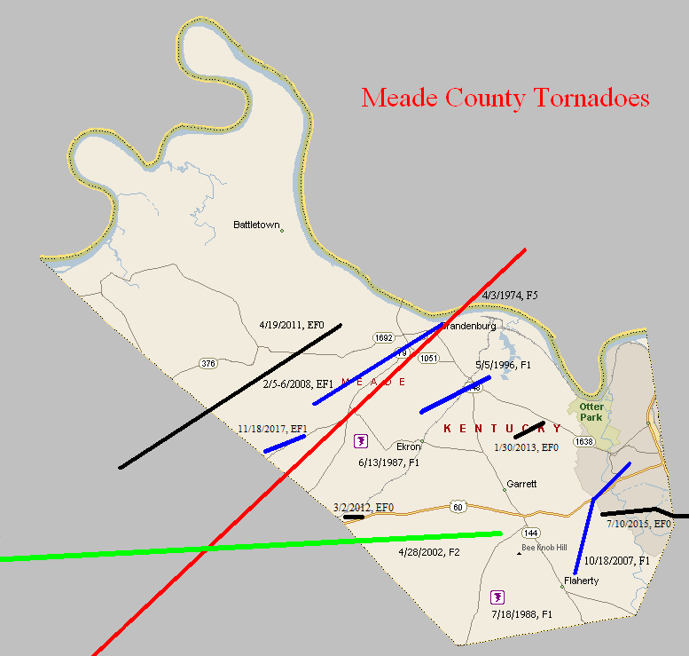
April 3, 1974
Counties: Breckinridge, Meade, Harrison IN
F-scale: F5
Deaths: 31
Injuries: 270
Path width:
Path length: 32 miles
Time: 2:20pm
Grazulis narrative: Touching down five miles southwest of Hardinsburg, Breckinridge County, the tornado passed along the northern edge of that town, with F3 damage to homes. Thirteen people were injured and 35 homes were destroyed as the funnel moved to the northeast across Breckinridge County and into Meade County. The tornado gradually enlarged and intensified as it approached Brandenburg. The funnel devastated that town and crossed the Ohio River into Harrison County, Indiana. At Brandenburg 128 homes were completely destroyed, many of them levelled and swept away. Thirty businesses were destroyed and damage totalled over ten million dollars. There were 28 deaths in the Brandenburg area. The F4 damage occurred from north of Irvington, into Indiana.
Noted discrepancies: SPC and NCDC give a time of 2:20pm, Grazulis gives 3:25pm, Storm Data 3:30pm. SPC and NCDC give a path length of 32 miles, Grazulis gives 34. SPC and NCDC give a path width of 430 yards, Grazulis give 800 yards.
June 13, 1987
Counties: Meade
F-scale: F1
Deaths:
Injuries:
Path width:
Path length:
Time: 5:30pm
Noted discrepancies: None
July 18, 1988
Counties: Meade
F-scale: F1
Deaths:
Injuries:
Path width:
Path length:
Time: 1:05pm
Noted discrepancies: None
May 5, 1996
Counties: Meade
F-scale: F1
Deaths:
Injuries: 10
Path width:
Path length:
Time: 4:05pm
Notes: Storm Data says this tornado moved from just north of Ekron to three miles southeast of Brandenburg.
April 28, 2002
Counties: Perry, Breckinridge, Meade
F-scale: F2
Deaths:
Injuries: 7
Path width:
Path length:
Time: 2:05am
Noted discrepancies: SPC lists a path width of 50 yards, NCDC and Storm Data list 150 yards. Storm Data takes this tornado from 3/10 of a mile southwest of Tobinsport to 1.8 miles east northeast of Tobinsport. Storm Data mentions that this tornado crossed into Kentucky from Perry County...hitting Irvington, two miles east northeast of Cloverport, and two and a half miles south of Garrett.
October 18, 2007
Counties: Meade
EF-scale: EF1
Deaths: 0
Injuries: 0
Path width: 300 yards
Path length: 2.5 miles
Time: 10:50pm EDT to 10:55pm EDT
Notes: This tornado began one mile northeast of Flaherty, damaged buildings at the intersection of US 60 and KY 1882, and lifted in western Fort Knox near Camp Carlson.
February 5-6, 2008
Counties: Meade
EF-scale: EF1
Deaths: 0
Injuries: 0
Path width: 350 yards
Path length: 6.5 miles
Time: 11:54pm EST to 12:05am EST
Notes: This tornado caused extensive tree and power line damage near Happy Ridge Road, Wood Dale Road, and Maple Grove Drive. Several businesses were damaged in the Broadway and Lakeview Drive area. A cinder block storage building was toppled. The tornado knocked down the exterior wall of another building. A storage building was lifted up and thrown across Broadway. The Old Brandenburg Telephone Company Office had roof damage. A church was damaged near the intersection of Broadway and KY 933.
April 19, 2011
Counties: Breckinridge, Meade
EF-Scale: EF-0
Deaths: 0
Injuries: 0
Path width: 50 yards
Path length: 11 miles (skipping)
Time: 11:54pm EDT
Notes: This tornado touched down 7.3 miles southwest of Payneville and skipped to 4.3 miles west of Brandenburg. It reached its peak strength on Sirocco Road where a carport attached to a house blew across a field, trees were snapped or uprooted, a barn door was blown in, and shingles were blown off of a nearby house.
March 2, 2012
Counties: Meade
EF-Scale: EF-0
Deaths: 0
Injuries: 0
Path width: 30 yards
Path length: 0.75 mile
Time: 4:02pm EST
Notes: The National Weather Service in conjunction with Meade County Emergency Management has determined that an EF-0 tornado with maximum wind speeds of 75 mph briefly touched down just east of the Breckinridge/Meade county line in Meade county. The tornado was photographed from Ekron, looking southwestward. Aerial photos of damage were also taken by volunteer general aviation pilots Mark Powers and Josh Kieffer and aerial photographer Austin Lassell in aircraft N16NA. The pilots were associated with the Kentuckiana Volunteer Aviators. Both the aerial photos and picture of the tornado relayed by the emergency manager were matched up with a radar signature indicating rotation. The tornado touched down near the Hill Grove and Guston area on the south side of U.S. 60, blowing a porch off the side of a house. A sign was also blown down at a business along U.S. 60
January 30, 2013
County: Meade
EF-Scale: EF0
Deaths: 0
Injuries: 0
Path width: 200 yards
Path length: 1 mile
Time: 4:05am EST
Notes: This tornado touched down in a grove of trees near the end of Kurtz Drive. The tornado traveled to the northeast and damaged homes on Kurtz Drive and at the intersection of Thornhill Drive and Gaines Road. Continuing to the northeast, at a home east of Gaines Road the owner reported that the water was evacuated out of all four toilets in the building as the tornado passed by. At the home next door the front door was pulling away from the building. Residents reported a loud roar. The tornado continued northeast through some woods and lifted after damaging a small shed off of Tom Cain Road.
July 10, 2015
County: Meade, Hardin
EF-Scale: EF0
Deaths: 0
Injuries: 0
Path width: 100 yards
Path length: 3.2 miles
Time: 10:35am - 10:41am EDT
Notes: A weak, skipping tornado occurred on Fort Knox. The tornado first touched down near the intersection of Lee Road and Fort Avenue just west of the military base's boundary. It traveled east over forested land, doing occasional damage to trees before it passed into Hardin County, 0.7 miles WSW of the U.S. Bullion Depository. It continued east for approximately 0.5 miles, then turned northeast over the PX and commissary complex before lifting 0.6 miles ENE of the base high school near Wilson Road. Several large hackberry and oak trees were uprooted and snapped between the PX and Scott Middle School. There was also some shingle damage to some of the buildings near the high school track. The tornado also caused significant tree damage from the middle school north/northeast across a remote area of the northeast part of the post.
November 18, 2017
County: Meade
EF-Scale: EF1
Deaths: 0
Injuries: 1
Path width: 50 yards
Path length: 1.8 miles
Time: 4:32pm EST
Notes: The tornado touched down just inside the Breckinridge-Meade County line north of Irvington. It pushed a large tobacco barn 15 feet eastward, tore off its roof, and collapsed several walls. Debris from the barn was scattered over a half mile downwind. The tornado moved east-northeast, skipping along a wooded area where several trees were snapped or uprooted, then hit a mobile home on Fackler Road, rolling the anchored unit several times, destroying the home. The owner sustained only minor injuries as he rolled over with his house, crawling out of a hole after it settled. A garage on the property was also destroyed. The tornado continued skipping along the northwest side of Sandy Hill Rd, damaging outbuildings on another farm, before crossing KY highway 261 at Guston Rd. A split level home on Guston Rd had part of its roof removed, with insulation spattered on the lee side of the home. An occupant of the home reported he was descending the
stairs as the roof was torn off, and was briefly drawn up the stairs as it occurred. Debris from the split level home was dropped across the road, where a few more trees were snapped and uprooted. The tornado then flattened a fence and peeled a section of sheet metal on an outbuilding before lifting.


 Weather Story
 Weather Map
 Local Radar