
Strong to severe thunderstorms capable of producing large to very large hail, damaging wind gusts and a few strong tornadoes are likely from the Midwest to the Mid-Atlantic tonight. Moderate Risk (level 4 of 5) of severe thunderstorms is outlooked for the Midwest. A widespread heat wave will peak in the South and East on Friday, with many temperature records expected to be broken. Read More >
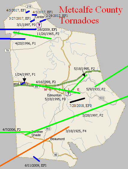
March 18, 1925
Counties: Allen, Barren, Monroe, Metcalfe (from Sumner TN)
F-scale: F4
Deaths: 39
Injuries: 95
Path width: 400 yards
Path length: 60 miles (probably a family of tornadoes)
Time: 5:00pm
Narrative: From one of the worst tornado outbreaks ever to strike central Kentucky. This tornado moved east-northeast from near Buck Lodge, eight miles north of Gallatin. Homes were swept away in many communities, including Keytown, Angle, Oak Grove, and Liberty. As many as eight people died in one home. Trees were blown down in the steep valleys as well as on the hilltops. At least 27 people died in Tennessee. Crossing into Kentucky, the tornado struck Mt. Union (near the present-day intersection of KY 1421 and Napier Road) and then Holland, killing four. The funnel may have either weakened or lifted over southern Barren County before striking Beaumont in Metcalfe County. There it killed eight more, including five in one family. Over 150 homes were damaged or destroyed.
May 9, 1933
Counties: Metcalfe, Adair
F-scale: F2
Deaths: 2
Injuries: 12
Path width: 400 yards
Path length: 15 miles
Time: 8:30pm
Narrative: Moved northeast, destroying five homes and damaging a dozen others at Columbia.
November 26, 1965
Counties: Metcalfe
F-scale: F2
Deaths: 1
Injuries: 1
Path width: 30 yards
Path length: 6 miles
Time: 11:00pm
Notes: Moved east from east of Hiseville to Savoyard and Sulphur Well. A trailer was demolished east of Savoyard, in which a woman named Glinda Jeffries was killed. Her body was carried about 100 yards. Her husband was injured. Their 2-year-old son remained unhurt.
Personal account from Brent Jeffries, cousin of Ronnie Jeffries, who was Glinda's husband: Tee Jeffries, Ronnie's father, went to the trailer to tell them that a bad storm was coming up and asked if they wanted to go to his house. Tee's house was right beside Ronnie's trailer. Ronnie said, "No we are just going to go to bed." So Tee started walking back to his house. Just as soon as Tee got on his car porch the tornado hit and sucked him up against the wall of his house. It threw Ronnie and Timmy, Ronnie's only son, into a mud puddle with just a few scratches. They found Glinda up in trees about 100 yards in front of her trailer. Tee climbed the tree and got her out. He said it felt like every bone in her body was broken but, she was still alive. They rushed her to T J Samson Community Hospital in Glasgow but, she died in Tee's arms about half a mile from the hospital. I was just 4 years old at the time but, I remember the wind blowing hard all that day. After the tornado hit my parents woke me up and we drove up there just about a mile away.
Noted discrepancies: SPC and NCDC give a path length of 5 miles, Grazulis and Storm Data give 6 miles (which appears more accurate). SPC gives a path width of 10 yards, NCDC 30 yards, Grazulis gives nothing. SPC/NCDC start this tornado at Savoyard in Metcalfe County...Grazulis and Storm Data start it "east of Hiseville" with Grazulis starting it in Barren County but Storm Data only mentioning Metcalfe County (Hiseville is three miles inside Barren County) on KY 314. In subsequent research, no evidence has been found of damage in Barren County, so will only include Metcalfe County at this time.
May 18, 1995
Counties: Metcalfe
F-scale: F0
Deaths: 0
Injuries: 0
Path width:
Path length: Less than one mile
Time: 5:04pm CDT
Notes: A state trooper spotted an F0 tornado at the Metcalfe County Fairgrounds.
Noted discrepancies: SPC gives a path length of one mile, NCDC and Storm Data say 14 miles. A path length of 14 miles would take this tornado out of Metcalfe County, so the SPC path length is used here. Storm Data only mentions damage at the fairgrounds.
May 18, 1995
Counties: Metcalfe
F-scale: F2
Deaths: 0
Injuries: 0
Path width: 200 yards
Path length: 6 miles
Time: 5:10pm CDT
Grazulis narrative: Tornado touched down in Edmonton then moved east-northeast along KY 80 to the Adair County line. A mobile home and three barns were destroyed. Several homes and a factory were damaged. Trees were blown down as well.
Noted discrepancies: Narrative given at the NCDC website and in Storm Data makes no sense.
April 20, 1996
Counties: Barren, Metcalfe
F-scale: F1
Deaths:
Injuries:
Path width:
Path length:
Time: 2:34am
Notes: Storm Data mentions damage at Queens Chapel Church and on KY 314, Spillman Road, and Thurmon-Sexton Road.
January 24, 1997
Counties: Metcalfe
F-scale: F1
Deaths:
Injuries:
Path width:
Path length:
Time: 5:50pm
Noted discrepancies: Storm Data lists this and the previous tornado as one.
Notes: Storm Data says this tornado lifted at Wisdom.
March 1, 1997
Counties: Metcalfe
F-scale: F0
Deaths:
Injuries:
Path width:
Path length:
Time: 11:25pm
Notes: Storm Data puts this tornado near Center.
March 28, 1997
Counties: Metcalfe, Adair
F-scale: F2
Deaths: 1
Injuries: 6
Path width:
Path length:
Time: 7:15pm
Noted discrepancies: SPC has beginning and ending lat/lons as 37.18/-85.32, 37.22/-85.08...NCDC has 36.88/-85.72, 37.03/85.45. SPC has a path length of 10 miles...NCDC says 15 miles. The lat/lon issue and path length issue here are the mirror image of the lat/lon issue and path length issue of the previous tornado. End lat/lon takes this tornado into Adair County, which agrees with NCDC narrative. Will plot into Adair County. Storm Data lists this tornado as having struck both Metcalfe and Adair counties, touching down a mile west of Summer Shade at the intersection of KY 90 and Milam Clark Road, crossing KY 90 and KY 640, KY 163 south of Goodluck, lifting just north of Breeding.
April 16, 1998
Counties: Metcalfe
F-scale: F2
Deaths: 1
Injuries: 0
Path width:
Path length:
Time: 3:53pm
Notes: Storm Data takes this tornado from Wisdom to two miles east of Edmonton.
April 7, 2006
Counties: Barren, Metcalfe
F-scale: F2
Deaths: 0
Injuries: 4
Path width: 200 yards
Path length: 2.7 miles
Time: 4:04pm
Notes: Fifteen to twenty homes were destroyed, mainly in the Temple Hill area. Another dozen or so homes, along with barns and outbuildings, sustained heavy damage. Four people in the area were treated for minor injuries. The tornado formed about a mile northeast of Temple Hill just south of Barbour Road. Numerous trees were topped, and several homes were damaged. Most of the structural damage occurred along Moore Road, where several mobile homes were moved considerable distances and were destroyed. A large RV was flipped over...a large tractor trailer was moved about five feet...and a horse trailer was thrown over 75 yards. The tornado reached its peak intensity near the intersection of Moore Road and KY 839. The storm then crossed into Metcalfe County about three miles northeast of Nobob. Several homes and barns were destroyed on Froedge-Dubree and Pitcock roads in the Summer Shade area.
May 8, 2009
Counties: Barren and Metcalfe
EF-scale: EF1
Deaths: 0
Injuries: 0
Path width: 30 yards
Path length: 4 miles (skipping)
Time: 3:04pm CDT - 3:11pm EDT
Notes: The tornado touched down just east of Hiseville on Buck Williams Road. A home and a small outbuilding were damaged, and numerous trees were uprooted. A piece of tin roofing ended up wrapped around a tree 500 yards to the east across an open field. The tornado peaked in intensity on a farm just north of Sexton Lane. Three outbuildings and a well-constructed barn were derstroyed. Debris from these structures was found up to 300 yards to the east in a pond. In Metcalfe County, south of Center, a pole barn was uplifted and scattered across a field.
June 11, 2009
Counties: Metcalfe, Monroe
EF-scale: EF1
Deaths: 0
Injuries: 0
Path width: 150 yards
Path length: 1.3 miles
Time: 8:01pm CDT
Notes: A small tornado traveled from northwest of Cyclone to south of Cyclone, damaging a few buildings and felling trees.
February 29, 2012
County: Metcalfe
EF-Scale: EF-1
Deaths: 0
Injuries: 0
Path width: 150 yards
Path length: 1.1 miles
Time: 12:47pm CST
Notes: The EF-1 tornado touched down southeast of Center, Kentucky near Herbert Hodges Road. It damaged 3 to 4 barns and snapped numerous trees along its 1.1 mile path. The tornado lifted 1.5 miles east-southeast of Center, Kentucky.
March 27, 2017
County: Metcalfe
EF-Scale: EF1
Deaths: 0
Injuries: 0
Path width: 100 yards
Path length: 0.3 mile
Time: 5:05pm - 5:06pm CDT
Notes: This squall line tornado was short lived but caused considerable destruction. It touched down about 0.3 mile southwest of Center, destroying two large barns and a small outbuilding in addition to taking the roof off of a small home. The front porch of a nearby home was briefly raised, causing the supports to fall out. The tornado moved northeast, streaming debris in a cyclonic pattern and into a nearby automotive repair shop that had one door blown in and another blown out. The large metal shop had minor roof damage, but was pierced in several locations by debris from the outbuildings to the southwest, and the entire facility was shifted slightly off of its foundation. Numerous vehicles near the repair shop sustained damage when hit by large debris from barns to the southwest. The cab of a small pickup was crushed by debris and the vehicle was blown onto KY 969. An RV parked next to the shop was blown into a utility pole. Several other vehicles had windows broken out. Metal roof panels from the buildings, along with insulation from a small home, were wrapped around trees as far as half a mile from their origin, with other small debris observed as far as 0.75 miles from the initial touchdown location.
April 5, 2017
County: Metcalfe
EF-Scale: EF1
Deaths: 0
Injuries: 0
Path width: 50 yards
Path length: 0.7 mile
Time: 5:11pm - 5:13pm CDT
Notes: This small tornado touched down near the intersection of Iron Mountain Road and Kidd Road where it heavily damaged a barn, then moved east-northeast over open farmland before hitting a farm on the west side of Center Three Springs Road. It tore the back end off of a large barn there and collapsed a 60-foot tall silo, then crossed the road and snapped several trees.
April 5, 2017
County: Metcalfe
EF-Scale: EF1
Deaths: 0
Injuries: 0
Path width: 50 yards
Path length: 0.4 mile
Time: 5:12pm - 5:13pm CDT
Notes: The tornado began in a field west of Center Peggyville Road, taking out several trees in a tree line before moving east where it destroyed a large, well-built barn, lofting debris into the air and sending it as far as 0.25 mile to the east. It then crossed the road and snapped several trees.
July 20, 2018
County: Metcalfe
EF-Scale: EF0
Deaths: 0
Injuries: 0
Path width: 60 yards
Path length: 2.1 miles
Time: 6:03pm - 6:05pm CDT
Notes: This short-lived spin-up occurred as a northeast-moving storm interacted with outflow winds from a southeastward-moving storm in eastern Metcalfe County. The first damage occurred along Subtle Road, where a carport was overturned and a large part of a metal outbuilding's roof was torn off, in addition to snapping numerous trees. The tornado then moved east-northeast at tree-top level over wooded areas and farm fields, doing its next major damage a mile away where it pushed a double-wide mobile home to the northwest off its blocks, breaking windows, and ripping off shingles from the roof. The tornado continued on for another mile, causing occasional tree damage and dropping debris before lifting near the east end of Groce Road, where it peeled roofing material from a metal out building.


 Weather Story
 Weather Map
 Local Radar