
Strong to severe thunderstorms capable of producing large to very large hail, damaging wind gusts and a few strong tornadoes are likely from the Midwest to the Mid-Atlantic tonight. Moderate Risk (level 4 of 5) of severe thunderstorms is outlooked for the Midwest. A widespread heat wave will peak in the South and East on Friday, with many temperature records expected to be broken. Read More >
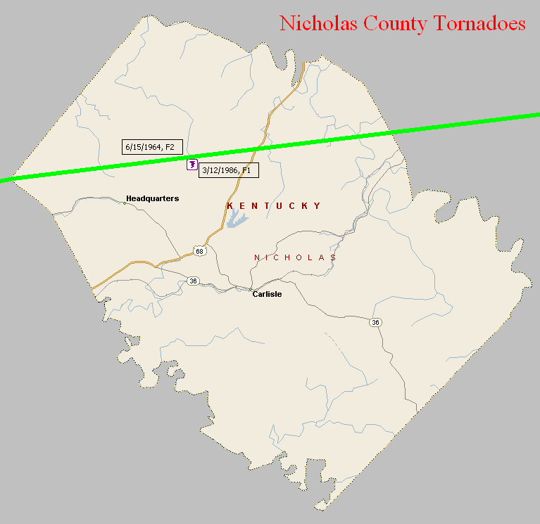
June 15, 1964
Counties: Scott KY, Harrison KY, Nicholas (and Fleming)
F-scale: F2
Deaths: 0
Injuries: 0
Path width: 30 yards
Path length: 49 miles
Time: 2:30pm
Grazulis narrative: Moved east, destroying barns and badly damaging two farm houses near Turkey Foot. This was one of a family of small tornado that skipped across three counties.
Noted discrepancies: At NCDC Scott County is listed twice and Harrison and Nicholas counties are not included. Storm Data only mentions Scott, Harrison, and Fleming counties (which doesn't make sense since Nicholas County is between Harrison and Fleming counties). The end lat/lon in the first NCDC Scott County entry is the same as the begin lat/lon in the second Scott County entry. Grazulis lists only Scott County...he does not specifically list Harrison or Nicholas...though he does mention that his Scott County tornado was "one of a family of small tornadoes that skipped across three counties" and he does mention Fleming County as being one of those three. SPC gives an ending lat/lon of 38.42/-83.73...NCDC gives 38.40/-83.93. SPC and NCDC give a path length of 49 miles, Grazulis gives one mile, Storm Data says 50 miles. SPC gives a path width of 10 yards, NCDC 30 yards, Grazulis gives nothing. Storm Data says the tornado touched down near Skinnersburg in Scott County, then lifted and touched down again at Turkey Foot in Scott County..."apparently across Harrison County", and then did damage near Flemingsburg. Should probably plot as one coherent tornado from Skinnersburg to Fleming, including all counties in between (and avoiding Bourbon County).
March 12, 1986
Counties: Nicholas
F-scale: F1
Deaths:
Injuries: 3
Path width:
Path length:
Time: 6:15am
Noted discrepancies: SPC/NCDC lat/lon is actually in Robertson County. Storm Data says the tornado touched down eight miles north of Carlisle on Ball Hill Road. We have plotted it according to Storm Data.


 Weather Story
 Weather Map
 Local Radar