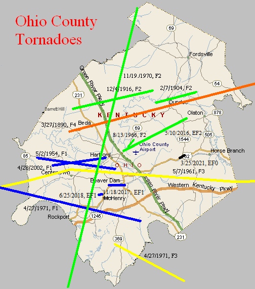
March 27, 1890
Counties: Ohio, Grayson, Breckinridge, Hardin
F-scale: F4
Deaths: 7
Injuries: 40
Path width: 1200 yards
Path length: 60 miles (probably a family of tornadoes)
Time: 8:00pm
Narrative: Moved east-northeast from seven miles northwest of Hartford. Many miles of forest were leveled, and small farm communities were wiped out. Homes were said to have "vanished" near Sulphur Springs (where two people were killed) and near Falls of Rough (where three people were killed). The last damage was near Rineyville, where two people were killed in one home.
February 7, 1904
Counties: Ohio
F-scale: F2
Deaths:
Injuries:
Path width:
Path length: 5 miles
Time: 3:45am
Narrative: Moved east-northeast from Dundee to Narrows. Thirty homes and six businesses were destroyed at Narrows (virtually the entire village). Twelve more homes were destroyed at Dundee.
December 4, 1916
Counties: Ohio
F-scale: F2
Deaths: 0
Injuries: 0
Path width: 100 yards
Path length: 10 miles
Time: 3:30pm
Narrative: Moved east-northeast seven miles north of Hartford. This tornado "bounced like a rubber ball" and destroyed several homes.
May 2, 1954
Counties: Ohio
F-scale: F1
Deaths:
Injuries:
Path width: 25 yards
Path length:
Time: Noon
Noted discrepancies: SPC gives a path width of 10 yards, NCDC gives 30 yards, Storm Data says 25 yards.
May 7, 1961
Counties: Ohio, Grayson (from Hopkins and Muhlenberg)
F-scale: F3
Deaths:
Injuries:
Path width:
Path length:
Time: 9:25am
Grazulis narrative: Skipped east-northeast from Madisonville to Bremen, Moorman, and on to Beaver Dam. The Moorman High School gym was unroofed and a small home fell over.
Noted discrepancies: SPC and NCDC rank this as an F3, Grazulis gives it an F2. Grazulis does not include Grayson County. SPC, Storm Data, and NCDC give a time of 9:25am, Grazulis give 8:15am. SPC and NCDC give a path length of 58 miles, Grazulis give 35 miles (skipping), Storm Data gives 60 miles. SPC and NCDC give a path width of 880 yards, Storm Data says 1320 yards, Grazulis says 200 yards. This tornado is very oddly listed at the NCDC website. NCDC lists Hopkins County at 9:25am, then two entries for Muhlenberg County (one at 9:36am and the other at 9:41am), then two entries for Ohio County (one at 9:48am and the other at 9:56am), then one entry for Grayson County (at 10:17am). All entries have identical f-scale and path widths values. Storm Data begins the tornado in McLean County, and thereafter agrees with SPC. The NCDC end lat/lon of the first Muhlenberg tornado is the same as the NCDC begin lat/lon of the second. Similarly, the NCDC end lat/lon of the first Ohio tornado is the same as the NCDC begin lat/lon of the second. All lat/lons are roughly in alignment with each other and with the Grayson County lat/lons. Will plot a single tornado as close to the given lat/lons as possible. In the LMK CWFA, only Centertown and Beaver Dam (both Ohio County) are mentioned in the Storm Data narrative. More research would be nice, especially to determine if this tornado did continue into Grayson County or not.
August 13, 1966
Counties: Ohio
F-scale: F2
Deaths:
Injuries:
Path width:
Path length:
Time: 5:25pm
Noted discrepancies: SPC/NCDC call this an F2...Grazulis does not list it.
Notes: Storm Data says this tornado touched down one and a half miles northeast of Hartford and moved northeast for a mile and a half.
November 19, 1970
Counties: Ohio
F-scale: F2
Deaths: 0
Injuries: 18
Path width: 600 yards
Path length: 37 miles (skipping)
Time: 10:25pm
Notes: This tornado likely touched down in eastern Muhlenberg County and traveled roughly northward through western Ohio County, including the Echols, Rockport, and Hartford areas, and into far eastern Daviess County around Whitesburg. In the Rockport and Echols area the tornado was up to a quarter mile wide. It destroyed a dozen houses and half a dozen mobile homes, damaged 40 other houses and several barns to some degree, and injured eleven people. In Hartford two children were hospitalized when their trailer was overturned. The tornado did its worst in Whitesville in Daviess County, damaging much of the town.
Noted discrepancies: SPC lists Ohio and Daviess counties...NCDC lists only Ohio County...Grazulis lists Muhlenberg and Ohio counties. SPC/NCDC lat/lon list this tornado as touching down in Daviess County, and provide no liftoff lat/lon. Grazulis has the tornado starting in Muhlenberg County east of Greenville and he lifts it at Hartford in Ohio County (nowhere near the SPC/NCDC lat/lon). SPC and NCDC list no injuries, Grazulis and Storm Data list 18. SPC gives a path length of 1/10 of a mile (obviously wrong), NCDC gives nothing, and Grazulis gives 20 miles. SPC gives a path width of 10 yards, NCDC and Grazulis give nothing. Storm Data mentions tornado-like damage at Whitesville in Daviess County.
April 27, 1971
Counties: Ohio (from McLean and Hopkins)
F-scale: F1
Deaths:
Injuries:
Path width:
Path length: 34 miles
Time: 6:45pm CDT
Noted discrepancies: Only Hopkins County is listed at NCDC. SPC gives a path width of 10 yards, NCDC give 30 yards. SPC and NCDC agree on a path length of 36 miles, suggesting the tornado must have continued beyond Hopkins County. Storm Data lists a path length of 34 miles. The SPC/NCDC liftoff lat/lon is in Oho County but makes no sense for a tornado coming from Hopkins and McLean counties, especially without passing through Muhlenberg County. Interestingly, though, SvrPlot gives a very realistic plot for this tornado. Storm Data says the tornado touched down near Slaughters in Hopkins County, proceeded to Sacramento in McLean County, and then went on to Prentiss in Ohio County.
Notes: Will use the Storm Data description.
April 27, 1971
Counties: Ohio, Butler
F-scale: F3
Deaths:
Injuries:
Path width:
Path length: 11 miles
Time: 7:10pm CDT
Notes: There is considerable disagreement among data sources regarding the end point of this tornado (despite excellent agreement on the touchdown point). After further research, it has been decided that this tornado touched down west of Cool Springs and north of Wysox in Ohio County. It proceeded to the east-southeast through Little Bend (near Mining City) and into Butler County. This project will end the tornado about two miles into Butler County. Damage was found as far east as the Reedyville and Roundhill areas along the Butler County/Edmonson County line, however these locations are not really in line with the earlier known tornado locations, and also there have been no damage reports found between the end point described above and these two locations. Damage in Roundhill and Reedyville may have been from straight-line winds or a separate small tornado. At this tornado's touchdown point in Ohio County a witness said it "swerved" as it approached his house, just grazing the home but destroying the garage and a nearby barn. Multiple vortices may have been visible. The tornado was witnessed at Little Bend and was described as being about 17 yards wide while moving at about 40mph (and accompanied by large hail). In this area a barn was destroyed and roof shingles were found embedded two inches deep into an oak tree. Will not disagree with the official strength ranking of F3, but it sounds like this tornado was a minimal F3 at best.
Noted discrepancies: SPC and NCDC rank this as an F3, Grazulis call it an F2. SPC and NCDC list a path width of 20 yards, Grazulis says 50 yards, Storm Data 14 yards.
April 28, 2002
Counties: Ohio
F-scale: F1
Deaths:
Injuries:
Path width:
Path length:
Time: 2:40am
Noted discrepancies: SPC lists a path width of 30 yards...NCDC and Storm Data say 100 yards.
Notes: Storm Data takes this tornado from five miles west of Centertown, on Shrull Lane, to Hartford.
May 10, 2016
County: Ohio
EF-Scale: EF2
Deaths: 0
Injuries: 0
Path width: 300 yards
Path length: 8.6 miles
Time: 6:06pm - 6:21pm CDT
Notes: This tornado briefly touched down on Spinks Drive just off of Highway 69. The tornado was only on the ground for approximately 200 yards with a path width of about 30-40 yards. A basement crawl space door was blown out along with siding and roof damage at 125 Spinks Drive. The tornado touched down for a second time at 41 El Retiro Ln where the path width increased to 50 yards and the winds speed increased to 90-95mph. Numerous large hardwood trees were snapped and twisted. An outbuilding, previously used to make brooms, next to the house had significant damage when a large tree fell on top of it. The tornado increased in size at 532 Stoneridge Ln. A custom-built home had exterior wall damage in the master bedroom with adjacent bathroom. Blow-in insulation blew out in all directions in the house and the back porch resembled a snow globe. Numerous trees and a grain silo were down along the property. The family survived the tornado by sheltering in a 3-foot crawl space. Winds in this area were 110 mph with a path width about 125 yards. The tornado continued to move east northeast along the countryside uprooting, twisting, and damaging numerous hardwood trees. The tornado significantly increased in width to approximately 300 yards and did a lot of damage along Halls Creek Rd. At 1130 Halls Creed Road 2-inch hail occurred before the tornado, with winds of 111 mph. Significant damage was done to the property, which included a 30x50 barn sliding the wall 12 feet. Along Walnut Rd, the tornado caused damage to several barns and numerous softwood trees and hardwood trees. Metal sheeting from barns was thrown in excess of 400 yards downwind. At the intersection of Highway 1164 and 1544 at the Cedar Grove Church there was roof damage to the church and many trees were twisted and uprooted. The last visible damage was along Highway 1544 just east of 1164 with some trees uprooted and twisted. About 30 feet from the tree there was an outbuilding that had half its roof blown off and the roof remnants were found about 50 yards away. The tornado ended approximately 400 yards from Highway 1544 near the intersection of 1164..
November 18, 2017
County: Ohio
EF-Scale: EF1
Deaths: 0
Injuries: 1
Path width: 60 yards
Path length: 2 miles
Time: 3:20pm CST
Notes: This small tornado was embedded in a fast moving squall line that raced east at 55 mph. The twister first touched down at a home on U.S. Highway 62 just west of Goshen Church Road, tearing off shingles and uprooting a tree. It moved east-southeast, uprooting and snapping trees near the intersection of Hwy 62 and Goshen Church Rd, along with damaging some small outbuildings. It next downed a tree on Mine Fork Road that fell between a home and outbuilding, damaging both structures and causing a minor head injury to the occupant of the shed. Continuing over open fields, it next hit several residences along Hill, Mulberry, and South Mulberry streets before crossing U.S. Highway 231 and causing minor roof damage to the Post Office. The greatest damage occurred in this two block area, where up to a dozen outbuildings were destroyed or heavily damaged, and sections of roofing were lifted off homes and garages. Fences in the neighborhood were blown in a cyclonic pattern, providing evidence of the tight rotation pattern of the storm. After crossing Hwy 231, the tornado damaged several large warehouses, scattering wood and sheet metal debris. Along Bruce School Road, a chain link fence was flattened, and insulation was sucked out of the damaged roof of a two story home, then spattered along the east side of the home and adjacent vehicles. Another large tree was uprooted in this yard before the tornado lifted. Sheet metal and shingles were lifted into trees along the route of the storm.
June 25, 2018
County: Ohio
EF-Scale: EF1
Deaths: 0
Injuries: 0
Path width: 100 yards
Path length: 0.6 mile
Time: 10:50am - 10:51am CDT
Notes: This brief tornado did most of its damage at treetop level, snapping the trunks of or uprooting at least two dozen large, mature oaks and cedars and causing limb damage to many others. In one case, it snapped the 2-foot diameter trunk of a large cedar less than 5 feet above the ground, but lofted the tree over nearby utility poles -- which remained intact -- and deposited the tree 200 feet to the east. The tornado did occasionally reach closer to the ground, causing significant damage to two structures. The first was a large brick ranch home which had most of the north half of its roof torn off, and insulation spread eastward in a narrow path. One piece of roofing lumber was found 500 feet ENE of the home. A second building, a large two-story brick industrial building 1/2 mile east, had about 20 percent of its metal roof peeled off. Immediately after hitting this building and downing trees in a nearby cemetery, it crossed US 62 and did additional tree damage as it moved through a wooded area.
March 25, 2021
County: Ohio
EF-Scale: EF0
Deaths: 0
Injuries: 0
Path width: 50 yards
Path length: 0.7 mi
Time: 8:32pm CDT
Notes: A bow echo created a very brief spin-up in Rosine. The tornado touched down about 200 yards west of the Dollar General store, which suffered some minor roof damage. A few trees were snapped and uprooted. Drone footage indicated the trees were lying in multiple directions. Winds in this area were estimated at 75 to 80 mph. The tornado skipped as it moved to the east-northeast with more substantial damage along KY 1544 in Rosine. Several homes received shingle damage along with more snapped and uprooted trees. A large carport was picked up and thrown about 50 yards, shearing off a telephone pole. A single wide mobile home was pushed off of its cinder block foundation southwestward about seven feet. Another mobile homer sustained roof damage and there was significant rock and mud spatter against three sides of the mobile home. Winds were estimated at 85 mph in this area with a width of 50 yards. There was a number of cedar trees that were sheared off half way up. Metal siding was thrown downwind up to 500 yards into the woods.


 Weather Story
 Weather Map
 Local Radar