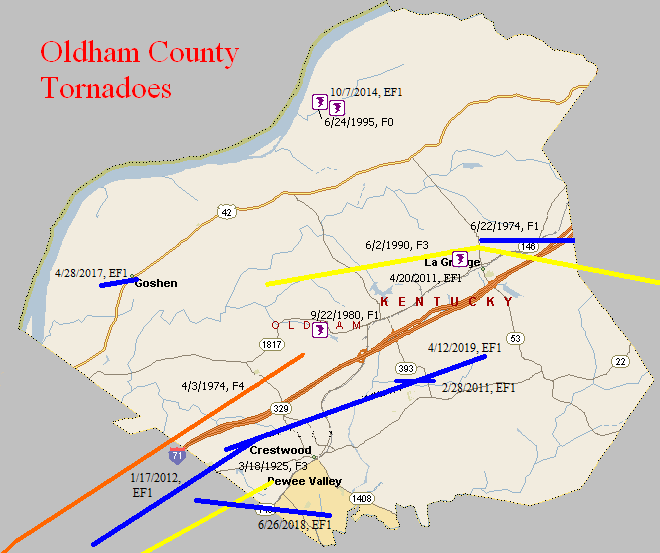
March 18, 1925
Counties: Jefferson KY, Oldham
F-scale: F3
Deaths: 3
Injuries: 40
Path width:
Path length: 10 miles
Time: 6:00pm
Narrative: Moved northeast from the east edge of Louisville to near Pewee Valley. At least a dozen homes were destroyed. An injured person at Pewee Valley may have died several weeks later. This tornado was probably spawned from the same thunderstorm that produced the earlier tornado in southwest Louisville (see previous entry). It appears to have touched down at Hike's Point along Taylorsville Road and Brown's Lane. Barns and outhouses were levelled, roofs were blown off, and a car was overturned. The tornado moved to the northeast through present-day Saint Regis Park and Hurstbourne. The twister may have lifted briefly as it crossed Shelbyville Road very near Eight Mile House (which was unaffected). The tornado caused intermittent damage through Anchorage, and then grew in intensity and remained on the ground from O'Bannon into Pewee Valley. The twister was 1/4 mile wide as it entered Pewee Valley where it destroyed a three-story brick home and a two-story frame house. A two-story house in Pewee Valley was swept ten feet off its foundation and collapsed. Trees blocked the Louisville-Pewee Valley road for two miles. Immediately after the storm, Lagrange Interurban cars leaving Louisville could not get beyond Lyndon. Two days after the tornado the tracks were still blocked beginning at O'Bannon Station. Hail up to 2 1/4 inches in diameter pounded Crescent Hill, and the stones had large "horns" on them.
March 25, 1964
Counties: Jefferson KY, Shelby, Oldham, Henry
F-scale: F2
Deaths: 0
Injuries: 1
Path width: 30 yards
Path length:
Time: 7:00pm
Grazulis narrative: Skipped east-northeast from just east of Standiford Field to Smithfield and New Castle. The "bounding" tornado, and accompanying high winds, unroofed or damaged four homes, 31 barns, and fifty other buildings.
Jefferson County: The Jefferson County portion of the track was well-covered in the local newspapers. The tornado touched down on the east side of Louisville International Airport at the intersection of Standiford Lane and Preston Highway, where it lifted and blew a car 40 feet, depositing it on its roof. The tornado grew to about two blocks wide and tore the roof off of a home at 4503 Zeta Court, dropping it in the back yard. Also on Zeta Court a car was flipped over. At about the same time a truck was flipped over at 2420 Cavelle Avenue. The tornado may have weakened or lifted slightly as the storm moved through Watterson Park and West Buechel. Damage then occurred again when a frame home's garage was torn from its foundation at 2835 Klondike Lane and was thrown 100 feet into the side of Saint Martha Catholic Church. On Dale Ann Drive a playhouse weighing 1500 pounds was blown 200 feet. After causing comparatively little damage in Houston Acres, the tornado strengthened again and grew to a width of about three blocks. On Cardwell Way a carport collapsed, three homes were damaged, and a car was demolished. Meanwhile, siding was removed from a home at 58 Hallsdale Drive and a garage was destroyed next door at 60 Hallsdale Drive. The tornado may have again weakened or lifted as the storm crossed Blue Ridge Manor and Anchorage. The last damage report in Jefferson County was on Collins Lane where homes and commercial buildings were damaged, and roofs were removed from barns. The head of the weather service office in Louisville, O. K. Anderson, surveyed the damage and said there was no doubt in his mind that it was a small, bounding tornado. Click here for a map of the Jefferson County portion of this tornado track. Louisville newspapers did not mention any damage in Oldham or Shelby Counties. There was mention of tornado damage in Smithfield and just outside New Castle in Henry County.
Noted discrepancies: Grazulis does not include Shelby County. NCDC does not list Oldham County or Henry County, and lists Jefferson County twice. Storm Data lists only Jefferson and Henry counties. SPC, Storm Data, and NCDC give a time of 7:00pm, Grazulis give 7:25pm. SPC gives and endpoint lat/lon of 28.50/-85.12...NCDC give 38.22/-85.45. SPC, Storm Data, and NCDC list one injury...Grazulis lists none. SPC gives a path length of 38 miles, NCDC gives 33 miles, Storm Data says 40 miles, Grazulis lists a skipping path of 23 miles. SPC gives a path width of 10 yards, NCDC 30 yards, Grazulis 40 yards. The second of the two Jefferson County entries at NCDC lists the touchdown point with the exact same lat/lon as the liftoff point in the first Jefferson County entry. Grazulis does mention that the tornado skipped. The NCDC touchdown lat/lon in Shelby County is not the same as the liftoff lat/lon in Jefferson County, though it ought to be if the tornado went directly from Jefferson County into Shelby County as one coherent tornado, so perhaps at the NCDC website the Shelby County event is a separate tornado, and is also a separate tornado according to Grazulis who perhaps felt it was not F2 and thus omitted it...? Grazulis takes the twister from Jefferson County into Oldham County (instead of Shelby County) and on into Henry County (agreeing with SPC's database). The touchdown and liftoff lat/lon given by SPC/NCDC agree perfectly with Grazulis. Using the touchdown and liftoff lat/lons at SPC, this tornado would have missed Shelby County. The end lat/lon given by NCDC for Shelby County is actually located in Henry County. Storm Data narrative says, "A small tornado of the bounding type moved in a straight line west-southwest to east-northeast from about half a mile east of Standiford Field...to approximately ten miles northeast. Apparently the same tornado continued northeastward into Henry County. It touched down several times in Jefferson County, and in Henry County...in the vicinities of Smithfield and New Castle." More research is necessary.
April 3, 1974
Counties: Jefferson KY, Oldham
F-scale: F4
Deaths:
Injuries:
Path width: 200 yards
Path length:
Time: 3:37pm
Grazulis narrative: Moved northeast from the Kentucky State Fairgrounds in Louisville. Dozens of buildings and hundreds of trees were destroyed in Louisville. About a dozen expensive homes were destroyed in affluent suburbs of northeast Louisville. About 425 homes were destroyed in Jefferson County, and 25 were damaged in Oldham County. Losses on one Oldham County farm amounted to $200,000.
Noted discrepancies: SPC and NCDC list three fatalities, Grazulis 2, Storm Data 6. SPC and NCDC list 225 injuries, Grazulis lists 228, Storm Data 243. SPC lists a path length of 19 miles, NCDC 18 miles, Grazulis 21 miles. SPC lists a path width of 10 yards (obviously incorrect), NCDC 30 yards (obviously incorrect), and Grazulis 200 yards.
June 22, 1974
Counties: Oldham
F-scale: F1
Deaths:
Injuries:
Path width:
Path length:
Time: 6:20pm
Noted discrepancies: None
September 22, 1980
Counties: Oldham
F-scale: F1
Deaths:
Injuries:
Path width:
Path length:
Time: 3:05pm
Notes: Storm Data mentions Demplytown and Buckner.
June 2, 1990
Counties: Oldham, Henry
F-scale: F3
Deaths: 0
Injuries: 5
Path width: 75 yards
Path length: 10 miles
Time: 10:30pm
Grazulis narrative: Moved east from just east of Goshen, passing one mile north of Lagrange, and through Jericho. At the edge of Lagrange three frame homes and three mobile homes were destroyed. A dozen other homes were damaged.
Noted discrepancies: SPC and NCDC give a path length of 10 miles, Grazulis give 9 miles. A straight line between SPC's touchdown and liftoff points doesn't quite fit with the description given by Grazulis (which agrees with Storm Data). Adjusted track here to agree with Storm Data/Grazulis. Grazulis times this tornado at 11:30pm.
June 24, 1995
Counties: Oldham
F-scale: F0
Deaths: 0
Injuries: 0
Path width: 50 yards
Path length: 1/2 mile
Time: 6:02pm
Notes: This appears to have been a westward moving tornado. A firefighter with the Westport Volunteer Fire Department saw the tornado begin on Eighteen Mile Creek Road, and proceed into Westport. Numerous trees were felled and several outbuildings were damaged. Many residents saw the tornado, and one person described it as looking like "a giant burnt curlicue French fry." The tornado hit the Westport General Store and blew down trees and power lines in town. Roofs were damaged as the tornado proceeded along Main Street/KY 524. Residents told the Louisville Courier-Journal that the tornado crossed the river and damaged trees on the Indiana shore, however that is not reflected in the official record. The record does state thast damaging straight-line winds were also associated with this storm, so perhaps the feeling was that any damage on the Indiana side was from non-tornadic wind.
February 28, 2011
Counties: Oldham
F-scale: EF1
Deaths: 0
Injuries: 0
Path width: 75 yards
Path length: 1.2 miles
Time: 4:43am to 4:45am EST
Notes: Numerous pine and cedar trees were uprooted or snapped and a few outbuildings were damaged. Homes had shingle and siding damage.
April 20, 2011
Counties: Oldham
EF-Scale: EF-1
Deaths: 0
Injuries: 0
Path width: 80 yards
Path length: 0.2 mile
Time: 12:49am EDT
Notes: The tornado destroyed a barn and snapped large hardwood trees where it touched down just northwest of LaGrange. Further to the northeast it destroyed another barn and damaged the roof of a house.
January 17, 2012
Counties: Jefferson KY, Oldham
EF-Scale: EF1
Deaths: 0
Injuries: 1
Path width: 250 yards
Path length: 8.2 miles
Time: 11:12am EST
Notes: The tornado touched down near the intersection of I-264 and Brownsboro Road. The tornado tracked northeast to near the intersection of Hurstbourne Lane and Brownsboro Road where it briefly lifted. The tornado then reformed and crossed I-265 and continued to the east-northeast through several subdivisions north and northeast of Fincastle. The tornado crossed into Oldham County, moving through Orchard Grass Hills and lifting at the northern tip of Clore Lane. Damage indicators along the path of this tornado included multiple softwood trees down, minor shingle damage to homes, a side wall downed in a large indoor tennis facility, and a barn roof collapse. An injury occurred as the tornado crossed I-265 when two semi trailers were blown over. The driver of one of the trucks was injured.
October 7, 2014
County: Oldham
EF-Scale: EF1
Deaths: 0
Injuries: 0
Path width: 50 yards
Path length: 0.1 mile
Time: 2:50pm - 2:51pm EDT
Notes: A barn, several outbuildings, and two trees were damaged.
April 28, 2017
County: Oldham
EF-Scale: EF1
Deaths: 0
Injuries: 0
Path width: 250 yards
Path length: 1.3 mile
Time: 11:53pm - 11:56pm EDT
Notes: The tornado developed in a subdivision in Goshen and traveled to the east northeast. Numerous trees were snapped or uprooted. A couple of houses and two church buildings sustained roof damage. Power lines and power poles were downed.
June 26, 2018
County: Jefferson KY, Oldham
EF-Scale: EF1
Deaths: 0
Injuries: 0
Path width: 150 yards
Path length: 3.5 miles
Time: 1:44pm - 1:46pm EDT
Notes: This tornado touched down at the entrance of Westport Woods Apartments. Across from the complex numerous trees were snapped or topped off. On Pacelli Place parts of trees were thrown into two houses, puncturing the siding. Most of the damage was high end EF0 around 85 mph with much of the damage being 20 to 50 yards off the ground. There were some hardwood trees uprooted and parts of them fell onto homes, fences, trampolines, and swing sets. Besides trees being twisted and turned in multiple directions, there was leaf and mud spattering on several homes in opposite directions of the storm movement. Intermittent tree top damage continued near Lake Louisvilla. At Westport Business Center there was significant roof damage with portions of the roofing material and parts of the roof supports 20 to 50 yards downwind and several windows blown out. At Ceva Logistics a large section of the north wall was pushed out due to 75-80mph winds. The tornado struck the north portion of Westport Bend Commerce Park, snapping and bending several trees. The tornado began to skip and struck a few trees in Forest Springs North before moving into Oldham County. The tornado lifted briefly before dropping back down on the east side of Pewee Valley near Five Forks Drive. Near Manassas Drive a trampoline was thrown 60 yards and a large sycamore tree was uprooted next to an air conditioner that was thrown to the north. The tornado then increased in strength and uprooted several trees along Hawley Gibson Road. One resident lost twenty softwood and hardwood trees, The tornado lifted just east of Hawley Gibson Road, twisting several trees on a farm there.
April 12, 2019
County: Oldham
EF-Scale: EF1
Deaths: 0
Injuries: 0
Path width: 300 yards
Path length: 8.3 miles
Time: 6:45am - 6:54am EDT
Notes: The tornado mostly did damage to the upper halves of several trees along its path. There were a couple of areas where it fully descended to the surface and caused more widespread damage. Along Shelburn Dr, a front porch with four columns was lifted, collapsing the columns and throwing the front half of the roof 100 yards to the northeast. The last visible damage was on Georgie Way.


 Weather Story
 Weather Map
 Local Radar
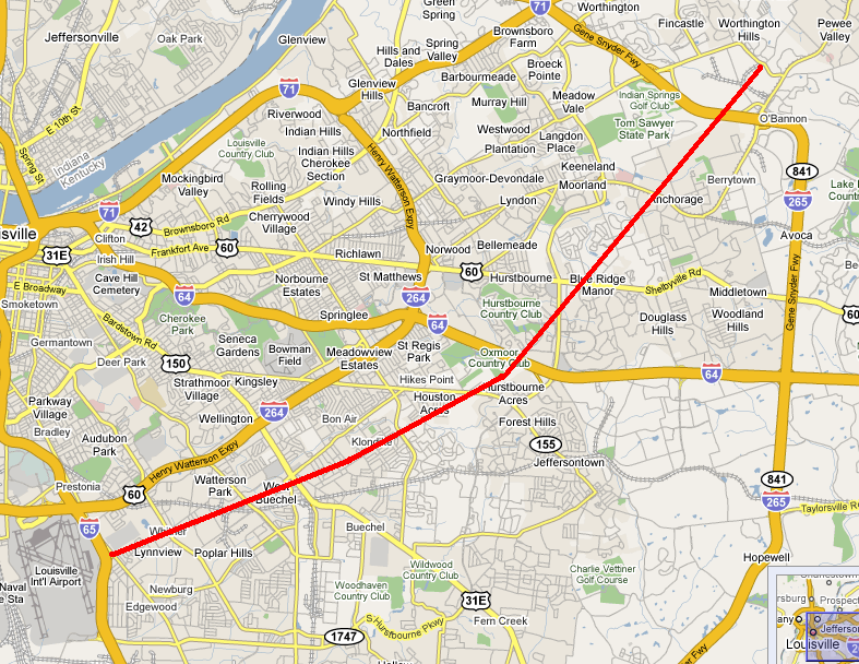