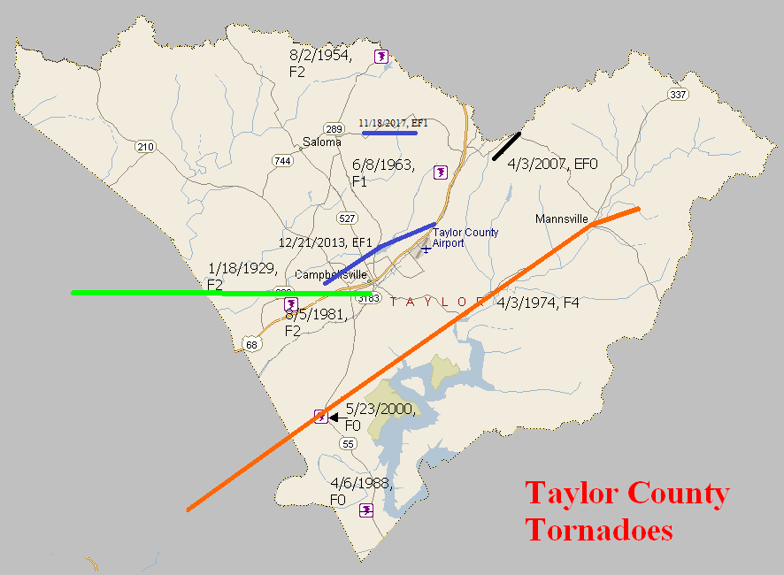
January 18, 1929
Counties: Green, Taylor
F-scale: F2
Deaths: 2
Injuries: 5
Path width: 100 yards
Path length: 12 miles
Time: 4:00pm
Narrative: Moved east from near Summersville to near Campbellsville. The deaths were in a home near the county line.
June 8, 1963
Counties: Taylor
F-scale: F1
Deaths:
Injuries:
Path width: 20 yards
Path length: 1/3 of a mile
Time: 1:00pm
Noted discrepancies: SPC gives a path width of 10 yards and a path length of 1/10 of a mile...NCDC gives nothing for either. Storm Data gives a path length of 500 yards and a width of 20 yards.
Notes: Storm Data says this tornado hit Palestine.
April 3, 1974
Counties: Green, Taylor
F-scale: F4
Deaths: 0
Injuries: 56
Path width: 800 yards
Path length:
Time: 4:40pm
Grazulis narrative: Moved northeast from south of Greensburg to Mannsville, destroying a large part of that town. About 50 homes and 60 barns were destroyed, and 40 of those were at Mannsville, with seven of them leveled to the ground.
Noted discrepancies: SPC and NCDC give a time of 4:40pm, Grazulis and Storm Data give 5:40pm. SPC gives a path length of 20 miles...NCDC gives 21 miles...Grazulis give 29 miles. SPC gives a path width of 10 yards...NCDC 30 yards...Grazulis 800 yards. Grazulis' width is probably most correct.
Notes: Storm Data says this tornado hit Mannsville, Burdick, Meadow Creek, and White Ridge.
August 5, 1981
Counties: Taylor
F-scale: F2
Deaths:
Injuries: 1
Path width:
Path length:
Time: 9:00pm
Noted discrepancies: NWS ranks this as an F2, Grazulis does not list it.
April 6, 1988
Counties: Taylor
F-scale: F0
Deaths:
Injuries:
Path width:
Path length:
Time: 6:10am
Noted discrepancies: None
May 23, 2000
Counties: Taylor
F-scale: F0
Deaths:
Injuries:
Path width:
Path length:
Time: 3:20pm
Noted discrepancies: SPC lists a path width of 20 yards, NCDC 27 yards, Storm Data 25 yards.
April 3, 2007
County: Taylor
EF-Scale: EF0
Deaths: 0
Injuries: 0
Path width: 25 yards
Path length: 1.3 miles (skipping)
Time: 8:01pm EDT
Notes: This small tornado first destroyed a 2-car garage 0.4 miles south of KY 744 on Smith Chapel School Road. It skipped northeast, damaging trees and two homes. It lifted just north of KY 744. Wind speeds were estimated around 85 mph.
December 21, 2013
County: Taylor
EF-Scale: EF1
Deaths: 0
Injuries: 0
Path width: 300 yards
Path length: 6 miles
Time: 11:07pm - 11:13pm EST
Notes: This tornado touched down along Old Greensburg Road just west of the intersection of US 68 and KY 323, where it immediately destroyed small outbuildings. The tornado entered the city of Campbellsville when it crossed KY 210 and uprooted trees and damaged buildings near the intersection of Hodgenville Road and Vintage Lane. A more concentrated area of damage then occurred as the tornado crossed Saloma Road and moved roughly parallel to and just north of Upper Miller Park Road. Trees were torn down and rooftops damaged in this area. The tornado exited the city at the intersection of Eastern Drive and East Lake Drive. The final damage occurred at the intersection of US 68 and Palestine Road. At this location there was more tree and roof damage.
November 18, 2017
County: Taylor
EF-Scale: EF1
Deaths: 0
Injuries: 0
Path width: 50 yards
Path length: 1.4 miles
Time: 6:00pm EST
Notes: This small, narrow squall-line spin-up tornado moved over rural countryside, damaging or destroying a half dozen outbuildings and doing minor tree damage as it traveled east-southeast over three farmsteads. Only minor roof damage occurred to one home in its path.


 Weather Story
 Weather Map
 Local Radar