Preliminary Storm Damage Survey for March 6, 2017National Weather Service St. Louis |
|
|
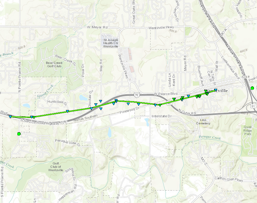
Date: 3/6/2017 Areas Affected: Wentzville, Missouri (St. Charles County, MO) |
|
|
Preliminary Damage Track: For the Wentzville Tornado
|
|
|
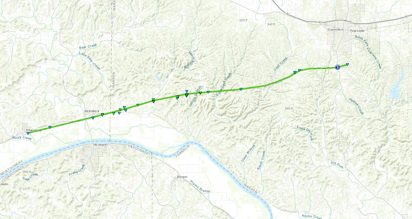
Date: 3/6/2017 Areas Affected: Southeast Montgomery County into western and central Warren County, Missouri Preliminary Damage Track: Rhineland, MO (Montgomery County, MO) to just south of Warrenton, MO (Warren County, MO)
NWS Damage Viewer: https://apps.dat.noaa.gov/StormDamage/DamageViewer/ The NWS Damage Viewer will allow the user to see an interactive and detailed map of the damage that was entered by the NWS storm survey team in the field and the ability to download the survey in GIS format (KML). While this information has been quality controlled, it remains preliminary and subject to change.
Click here for YouTube Video Instructions for the NWS Damage Viewer
|
|
|
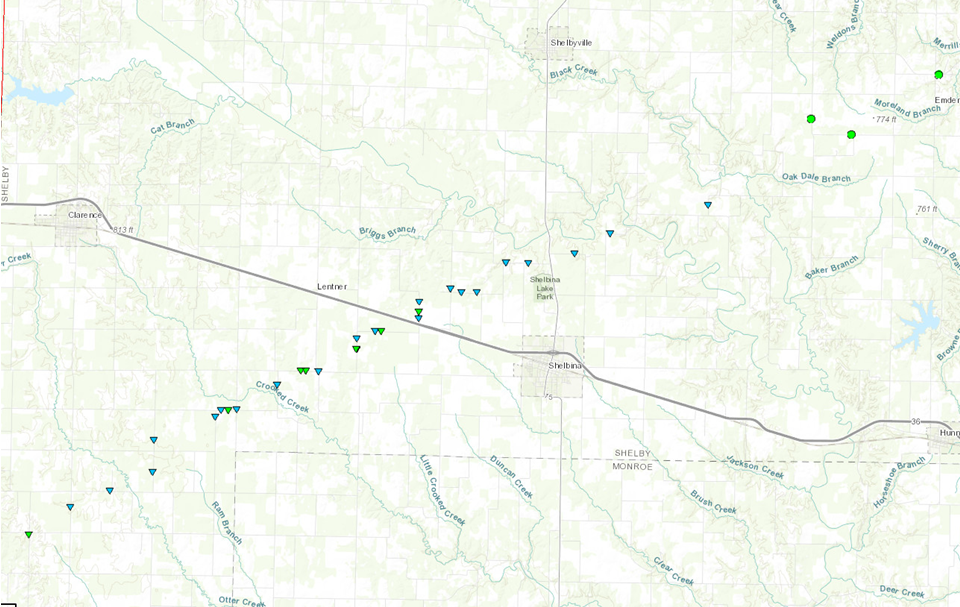
Public Information Statement: Public Information Statement National Weather Service Saint Louis MO 820 PM CST Tue Mar 7 2017 ILZ058>060-064-065-069-070-074-079-095>102-MOZ018-019-026-027- 034>036-041-042-047>052-059>065-072>075-084-085-099-080830- 820 PM CST Tue Mar 7 2017 ...NWS Damage Survey for 03/06/2017... ...Montgomery, Warren and St. Charles Counties in Missouri... .Overview... A small scale vortex developed along the leading edge of a squall line of thunderstorms in southern Montgomery County near Rhineland and moved east/northeast across Warren and St. Charles Counties. It produced two weak tornadoes that were rated EF1 on the Enhanced Fujita Scale. .Rhineland to 2SSE Warrenton, Missouri... Rating: EF-1 Estimated peak wind: 100 mph Path length /Statute/: 21 miles Path width /Maximum/: 150 yards Fatalities: 0 Injuries: 0 Start date: March 6th, 2017 Start time: 11:17 PM CST Start location: Rhineland Start Lat/Lon: 38.7166/-91.5152 End date: March 6th, 2017 End time: 11:38 PM CST End location: 2SSE Warrenton End Lat/Lon: 28.7802/-91.1366 Survey Summary: A continuous path of damage was observed from Rhineland to two miles south/southeast of Warrenton, Missouri (east of Missouri Highway 47). The tornado developed near the baseball fields in Rhineland along Highway 94 and moved east causing damage to several trees, fences and the roof of a building on the grounds. The tornado continued east paralleling Highway 94 and causing varying amounts of damage to homesteads and farm buildings. It crossed Highway 19 just north of Highway 94 and caused mainly tree damage until it reached Engemann Farm Road where a barn and garage were destroyed. The tornado continued east causing damage to trees along Case Road and then expanded as it crossed Massas Creek Road to nearly 150 yards. It is at this point that the greatest tree damage occurred with numerous trees uprooted, twisted and snapped in a convergent pattern near the creek. The tornado then crossed Highway B and Centenial Drive with more large trees uprooted and some minor damage to outbuildings and residences noted. The tornado continued east, destroying a pole barn west of Hickory Heath Ranch Road, and uprooting more trees along State Highway EE and Missouri Highway U. The tornado crossed Highway 47 south of Warrenton causing roof damage to a building of a private campground and then dissipated east of the campground in rural Warren County. The total path length of this EF1 tornado was 21 miles. .Wentzville, Missouri... Rating: EF-1 Estimated peak wind: 100 mph Path length /Statute/: 3 miles Path width /Maximum/: 100 yards Fatalities: 0 Injuries: 3 Start date: March 6 2017 Start time: 11:51 PM CST Start location: 3W Wentzville Start lat/lon: 38.8051/-90.9085 End date: March 6 2017 End time: 11:54 PM CST End location: Wentzville End lat/lon: 38.8111/-90.8504 Survey Summary: The second tornado associated with the small vortex developed along the South Service Road of Interstate 70 west of South Pointe Prarie Road. The tornado crossed Interstate 70 and caused roof and siding damage to a number of homes and uprooted or snapped trees along its path as it moved east across Langtree Drive, Shadow Point Circle, Shadow Pines Drive, Giotto Court, Cabot Court, Tiffany Lynn Court, Huntsdale Drive, Tiger Drive and Ivybrook Drive. The tornado once again approached Interstate 70 causing damage to several business along W Pierce Blvd. The tornado crossed the Interstate, flipping over a large camper trailer along Thomas RV Way and flattening several road signs. The tornado tracked east paralleling Interstate 70, causing varying degrees of damage to buildings along Swantherville Drive and Ruggeri Drive. The tornado then caused significant roof damage to a building along P&A Drivewall Drive before crossing Interstate 70 for the third and final time. The tornado continued east into a mobile home park where it flipped one trailer over and damaged many more. This is where the three injuries occurred. The tornado continued east/northeast just to the south of West Main Street through Downtown Wentzville causing mainly minor damage to many residences and businesses. The exception was a lumber business along South Church Street which took the brunt of the tornado and had a large building destroyed. The tornado finally dissipated near the intersection of Pitman Avenue and South Tally Street. NOTE: The information in this statement is PRELIMINARY and subject to change pending final review of the events and publication in NWS Storm Data. $$ Areas Affected: Rural Shelby County Missouri between Shelbyville and Shelbina Preliminary Damage Track: For the Shelbina Tornado
NWS Damage Viewer: https://apps.dat.noaa.gov/StormDamage/DamageViewer/ The NWS Damage Viewer will allow the user to see an interactive and detailed map of the damage that was entered by the NWS storm survey team in the field and the ability to download the survey in GIS format (KML). While this information has been quality controlled, it remains preliminary and subject to change. Click here for YouTube Video Instructions for the NWS Damage Viewer
Public Information Statement:
Public Information Statement
National Weather Service Saint Louis MO
528 PM CST Tue Mar 7 2017

ILZ058>060-064-065-069-070-074-079-095>102-MOZ018-019-026-027-
034>036-041-042-047>052-059>065-072>075-084-085-099-080530-
528 PM CST Tue Mar 7 2017

...NWS DAMAGE SURVEY FOR MARCH 6 2017 TORNADO EVENT...

.Shelby County Missouri...

Rating:                 EF-1
Estimated peak wind:    100 mph
Path length /Statute/:  16 miles
Path width /Maximum/:   150 yards
Fatalities:             0
Injuries:               1

Start date:             March 6 2017
Start time:             9:40 pm CST
Start location:         13.4 Southwest of Shelbina
                        36.6335, -92.2808

End date:               March 6 2017
End time:               9:56 pm CST
End location:           5.5 Northeast of Shelbina
                        39.7505, -91.9681


A tornado moved from extreme southwest Shelby County, MO to northeast of
Shelbina. The bulk of the damage was EF-0, primarily to trees and farm
outbuildings. The South Shelby High School was also hit. It suffered
minor roof damage, a couple of storage buildings were destroyed, the
baseball backstop was destroyed, and the press box was blown off the
football field bleachers and destroyed. One home just northeast of the
high school had a portion of its roof blown off. Intermittent tree and
farm outbuilding damage continued until about 5.5 miles northeast of Shelbina.
One injury occurred. A man was cut on the forehead by flying debris
and required stitches.

EF Scale: the Enhanced Fujita Scale Classifies
Tornadoes into the following categories.

EF0...Weak......65 to 85 mph
EF1...Weak......86 to 110 mph
EF2...Strong....111 to 135 mph
EF3...Strong....136 to 165 mph
EF4...Violent...166 To 200 mph
EF5...Violent...>200 mph

NOTE:
The information in this statement is PRELIMINARY and subject to
change pending final review of the event and publication in
NWS Storm Data.

$$
|


 Weather Story
 Weather Map
 Local Radar