Severe Weather
| Severe Thunderstorm Watch | Potential for severe thunderstorms |
Severe thunderstorms are possible in and near the watch area. Stay informed and be ready to act if a severe thunderstorm warning is issued. The watch area is typically large, covering numerous counties or even states. |
| Tornado Watch | Potential for tornadic storms | Tornadoes are possible in and near the watch area. Review and discuss your emergency plans, take inventory of your supplies and check your safe room. Be ready to act quickly if a warning is issued or you suspect a tornado is approaching. Acting early helps to save lives! Watches are issued by the Storm Prediction Center for counties where tornadoes may occur. The watch area is typically large, covering numerous counties or even states. |
| Severe Thunderstorm Warning | Hail of 1"+ in diameter or wind gusts 50kts+ (58mph) | Severe weather has been reported by spotters or indicated by radar. Warnings indicate imminent danger to life and property. Take shelter in a substantial building. Get out of mobile homes that can blow over in high winds. Warnings typically encompass a much smaller area (around the size of a city or small county) that may be impacted by a large hail or damaging wind identified by an NWS forecaster on radar or by a trained spotter/law enforcement who is watching the storm. |
| Tornado Warning | A tornado is strongly suspected or is occurring | A tornado has been sighted or indicated by weather radar. There is imminent danger to life and property. Move to an interior room on the lowest floor of a sturdy building. Avoid windows. If in a mobile home, a vehicle, or outdoors, move to the closest substantial shelter and protect yourself from flying debris. Warnings are issued by your local forecast office. Warnings typically encompass a much smaller area (around the size of a city or small county) that may be impacted by a tornado identified by a forecaster on radar or by a trained spotter/law enforcement who is watching the storm. |
Flooding
| Flood Watch | Potential for flash flood criteria |
| Flood Advisory | Nuisance flood that doesn't threaten to life or property |
| Flash Flood Warning | Short-term, rapid-onset flooding that require immediate action to protect lives and property |
| Flood Warning | Longer-term flooding that does not necessarily require immediate action, but still threatens life and property. |
Winter Weather
| Winter Weather Advisory | At least one of the following:
|
Be prepared for winter driving conditions and possible travel difficulties. Use caution when driving. |
| Winter Storm Watch | Potential for Winter Storm/Blizzard/Ice Storm Warning criteria | Prepare for winter storm, ice storm, or blizzard conditions depending on the situation. Stay informed with the latest NWS forecast. |
| Winter Storm or Ice Storm Warning | At least one of the following:
|
|
| Blizzard Warning |
Persisting for 3+ hours:
|
Falling and blowing snow with strong winds and poor visibilities are likely, leading to whiteout conditions making travel extremely difficult. Do not travel. If you must travel, have a winter survival kit with you. If you get stranded, stay with your vehicle and wait for help to arrive. |
| Snow Squall Warning |
Heavy bursts of snow within a short period of time (usually less than one hour) causing rapid deterioration to travel conditions.
"General" Snow Squall Warnings will not trigger the WEA, and are issued when mitigating societal factors (time of day, day of week) exist. "Significant" warnings do trigger the WEA. |
If a snow squall warning is issued for your area, avoid or delay motor travel until the squall passes through your location. There truly is no safe place on the highway during a snow squall. However if you are already in transit and cannot exit the road in time, reduce your speed, turn on your headlights and hazard lights and allow plenty of distance between you and the car in front of you. It’s also best not to slam on your brakes. With slick/icy roads, this could contribute to the loss of vehicle control and also increase the risk of a chain reaction crash. |
Cold
| Cold Weather Advisory | Please see this map for more detail |
| Extreme Cold Watch | Potential for Extreme Cold Warning criteria |
| Extreme Cold Warning | Please see this map for more detail |
Heat
| Heat Advisory |
|
| Extreme Heat Watch | Potential for Extreme Heat Warning criteria |
| Extreme Heat Warning |
|
Non-Thunderstorm Wind
| Wind Advisory |
|
| High Wind Watch | Potential for High Wind Warning criteria |
| High Wind Warning |
|
Fire Weather
| Elevated Fire Danger | 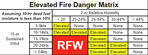 |
| Fire Weather Watch | Potential for Red Flag Warning criteria |
| Red Flag Warning |
|
Vision Obstruction
| Dense Fog Advisory | Visibilities of 1/4 mile or less due to fog, may include light accumulations of ice due to sub-freezing temperatures |
| Dense Smoke Advisory | Visibilities of 1/4 mile or less due to smoke |
Frost/Freeze (these are agricultural products only issued in the growing season)
| Frost Advisory | Widespread frost (temperatures in mid-30s, light winds, and dew potential) |
| Freeze Watch | Potential for widespread temperatures of 32F or below |
| Freeze Warning | Widespread temperatures of 32F or below |


 Weather Story
 Weather Map
 Local Radar