Overview
|
Overnight on Sunday, November 3rd, a shield of rain and thunderstorms moved into the bi-state area. By Monday morning, persistent rainfall resulted in fatal flash flooding in southeast Missouri, with one fatality occurring in Iron County. Later on Monday evening, a QLCS produced two EF-0 tornadoes in east- central Missouri and shifted the axis of heaviest rain to the north. Due to the shift northward, record rainfall amounts caused deadly flash flooding in the St. Louis metropolitan area on Tuesday morning with two fatalities caused by rising waters. Below is a more in-depth summary of the November 4th and 5th event. |
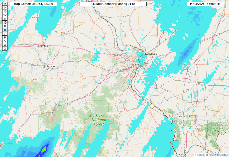 QPF Loop from Midday November 3rd Until Midday November 5th |
Tornadoes:
|
Tornado - Flint Hill, MO
Track Map 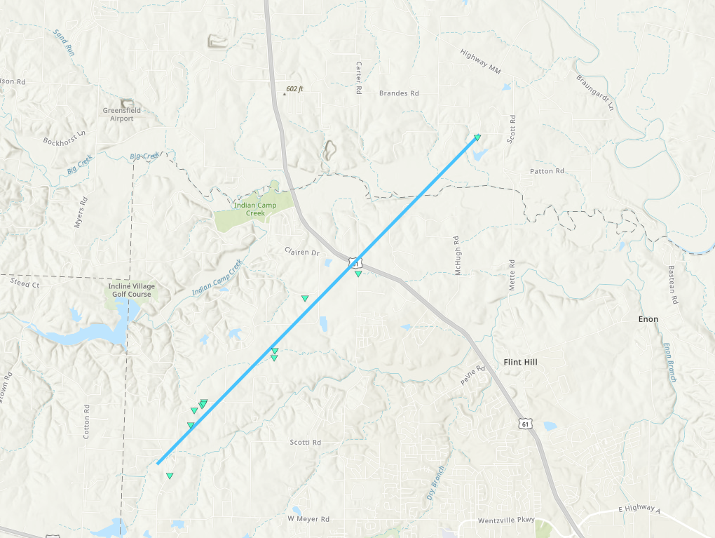 
Downloadable KMZ File |
||||||||||||||||
|
Tornado - Truxton, MO
Track Map 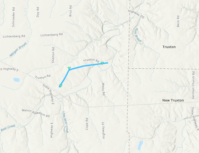
Downloadable KMZ File |
||||||||||||||||
The Enhanced Fujita (EF) Scale classifies tornadoes into the following categories:
| EF0 Weak 65-85 mph |
EF1 Moderate 86-110 mph |
EF2 Significant 111-135 mph |
EF3 Severe 136-165 mph |
EF4 Extreme 166-200 mph |
EF5 Catastrophic 200+ mph |
 |
|||||
Flooding and Record Rainfall
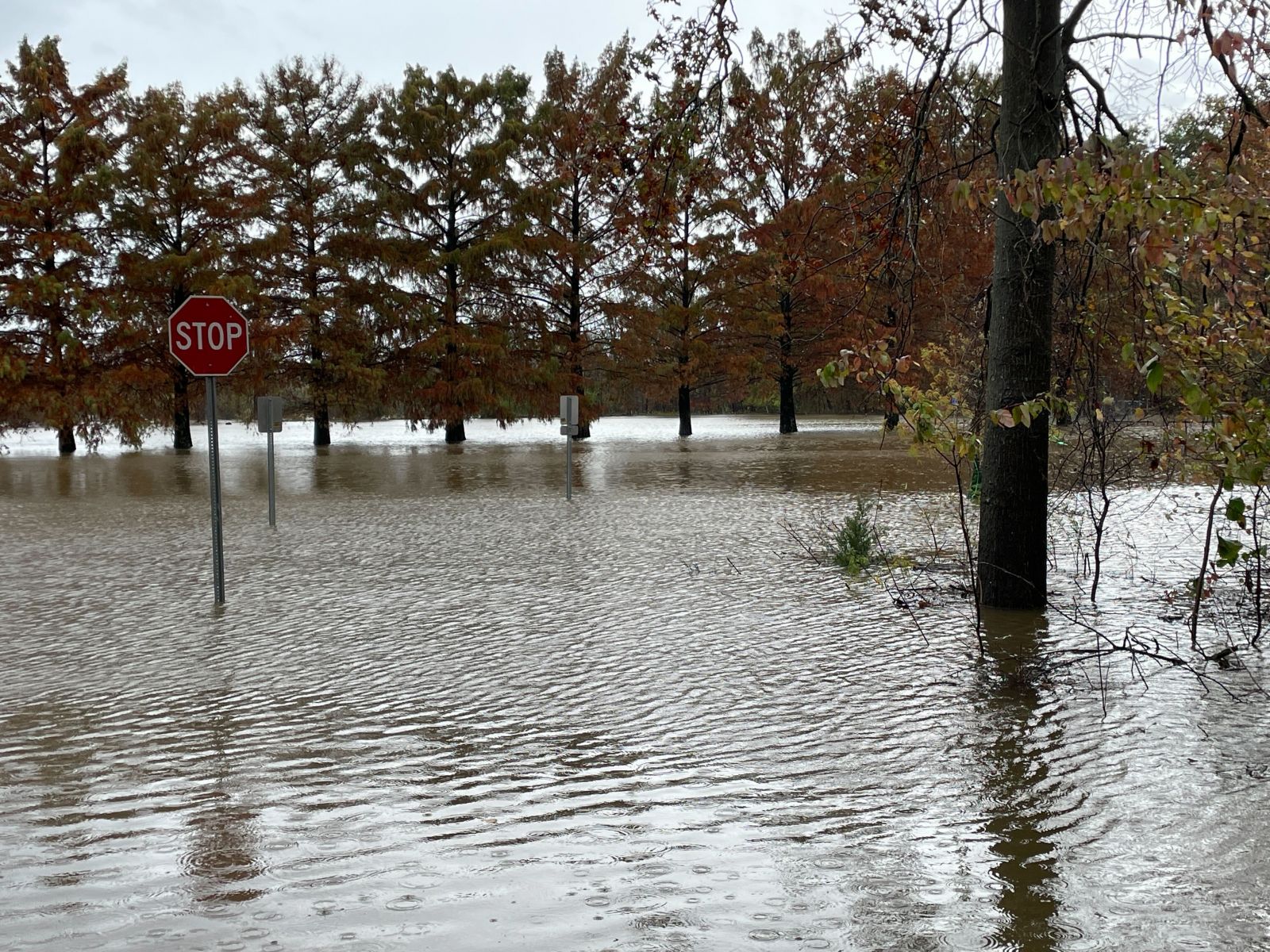
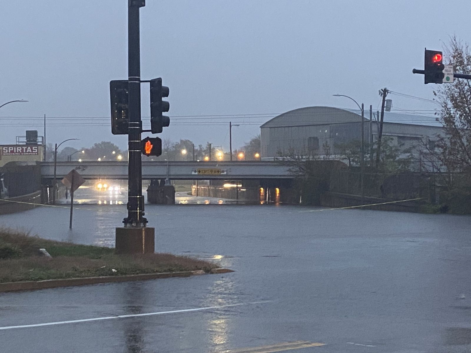
Persistent showers and thunderstorms resulted in deadly flash flooding in east-central and southeast Missouri during the November 4th-5th period. Prior to October 30th-31st, the region had been in a serious drought caused by an extended period without beneficial rain. However, these dry antecedent conditions were dampened by severe weather on Halloween morning and by additional rounds of rain over the following weekend. This aided in the occurrence of flash flooding in southeast Missouri. In the St. Louis metropolitan area, the abundance of concrete surfaces also worked in tandem with record rainfall amounts to cause the flash flooding of area roads and interstates. Sadly, three individuals lost their lives to flash flooding during this event.
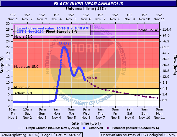
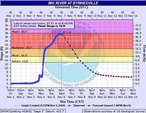
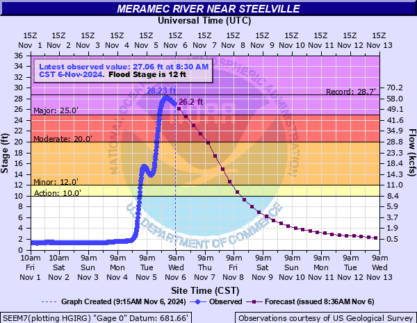
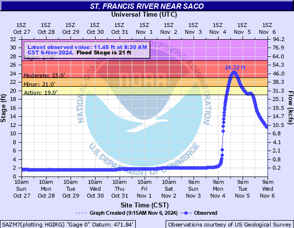
The abundant rainfall also caused river flooding, with the Big, Black, Meramec, and St. Francis rivers seeing the most extreme rises. Some forecast points along these rivers experienced a jump from well below action stage to moderate flooding within the course of hours. The Meramec River experienced highest rises overall, with nearly all of its forecast points either reaching or forecast to reach major flood stage in the days after the event. Local creeks also saw extreme rises, with multiple points either nearing or exceeding record crests previously set by rainfall from Hurricane Ike in 2008.
Record rainfall fell at Lambert International Airport in St. Louis on Tuesday, November 5th. The daily maximum rainfall amount was set at 3.89 inches, shattering the old record of 1.62 inches set in 1956. This value also set a new monthly record for single day rainfall in the month of November, breaking the previous record of 3.75 inches set a day prior on November 4th, 2024. These values broke the longstanding record of 3.56 inches set in 1921.
River Hydrographs as of 11/06/14
 |
 |
 |
 |
|
Black River at Annapolis |
Big River at Byrnesville |
Meramec River near Steelville |
St. Francis River near Saco |
Peak Crests of St. Louis County Creeks 11/3 - 11/6
.gif) |
.gif) |
 |
 |
|
Gravois Creek at Mehlville 19.71 ft: Record Highest Crest |
Deer Creek at Ladue 21.68 ft: 2nd Highest Crest Ever |
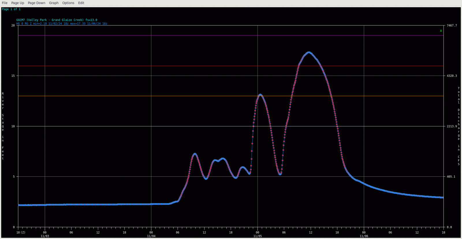
Grand Glaize Creek at Valley Park 17.33 ft: 2nd Highest Crest Ever |
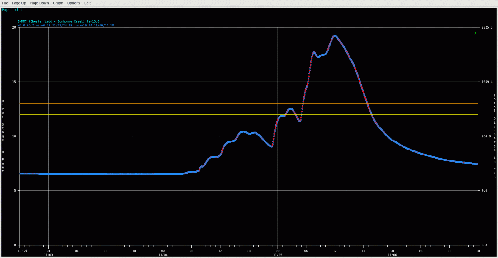
Bonhomme Creek at Chesterfield 19.24 ft |
Photos and Rainfall Map
 |
 |
 |
-RainfallAnalysisPublic1.png) |
|
Dardenne Creek at Rabbit Run Park in St. Peters, MO Photo Credit: Stacy Lynn |
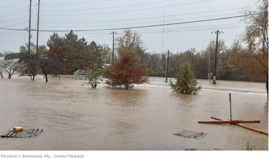
Brentwood, MO Photo Credit: Jordan Howard |
Skinker Blvd at Olive St in St. Louis, MO Photo Credit: STLPD |
Estimated Total Rainfall Map 11/2 7am - 11/5 6am |
Flooding and Rain-Related Storm Reports
..TIME... ...EVENT... ...CITY LOCATION... ...LAT.LON...
..DATE... ....MAG.... ..COUNTY LOCATION..ST.. ...SOURCE....
..REMARKS..
0241 PM Rain Freeburg 38.42N 89.91W
11/05/2024 M4.40 Inch St. Clair IL Emergency Mngr
Storm total (since Sunday).
0220 PM Rain 1 N Saint Peters 38.79N 90.61W
11/05/2024 M4.08 Inch St. Charles MO Trained Spotter
Storm total.
0215 PM Rain Granite City 38.71N 90.13W
11/05/2024 M8.62 Inch Madison IL Cocorahs
Event total since early Sunday morning.
0211 PM Rain Chesterfield 38.65N 90.58W
11/05/2024 M6.82 Inch St. Louis MO Broadcast Media
Total rainfall.
0203 PM Rain 1 E Ellisville 38.59N 90.57W
11/05/2024 M9.31 Inch St. Louis MO Trained Spotter
Total rainfall.
0126 PM Rain Desloge 37.88N 90.52W
11/05/2024 M9.11 Inch St. Francois MO Public
0125 PM Rain Cedar Hill 38.36N 90.64W
11/05/2024 M7.00 Inch Jefferson MO Trained Spotter
24 hour rainfall total.
0100 PM Rain Sullivan 38.22N 91.17W
11/05/2024 M6.11 Inch Franklin MO Trained Spotter
24 hour rainfall since 1PM on 11/4. Spotter
stated they reported just over 4 inches
yesterday at this time and estimated just
over 10 inches total in the last 48 hours.
1233 PM Rain 1 W Oates 37.57N 91.07W
11/05/2024 M10.80 Inch Reynolds MO Public
Twitter report. Storm total.
1146 AM Rain Sunset Hills 38.54N 90.42W
11/05/2024 M8.88 Inch St. Louis MO Public
1123 AM Rain 1 SW Fenton 38.53N 90.47W
11/05/2024 M8.54 Inch St. Louis MO Public
1123 AM Rain Ballwin 38.59N 90.55W
11/05/2024 M8.34 Inch St. Louis MO Public
Corrects previous rain report from Ballwin.
1121 AM Rain 3 N Union 38.49N 91.01W
11/05/2024 M8.30 Inch Franklin MO Trained Spotter
Storm total so far; still lightly raining.
1121 AM Rain 5 SE Oak Hill 38.15N 91.36W
11/05/2024 E11.00 Inch Crawford MO Public
Public reported at least 11 inches of rain
in last 36 hours.
1121 AM Rain Mineral Point 37.95N 90.72W
11/05/2024 M6.91 Inch Washington MO Public
1120 AM Rain Rosebud 38.39N 91.40W
11/05/2024 M6.35 Inch Gasconade MO Public
1054 AM Rain 1 SW Crestwood 38.54N 90.39W
11/05/2024 M9.00 Inch St. Louis MO Public
1034 AM Flood 4 W Anthonies Mill 38.07N 91.16W
11/05/2024 Crawford MO Law Enforcement
Trooper is reporting that the Meramec river
is 4 ft over the road at Campbell bridge on
Highway N.
1014 AM Rain 2 SE Trenton 38.59N 89.66W
11/05/2024 M4.94 Inch Clinton IL Public
0856 AM Rain 4 NW Villa Ridge 38.51N 90.94W
11/05/2024 M8.10 Inch Franklin MO Public
0852 AM Rain 1 E Saint Peters 38.78N 90.59W
11/05/2024 M6.40 Inch St. Charles MO Amateur Radio
0845 AM Rain Crestwood 38.56N 90.38W
11/05/2024 M9.31 Inch St. Louis MO Public
Storm total so far. Still raining lightly.
0838 AM Rain Chesterfield 38.66N 90.58W
11/05/2024 M6.55 Inch St. Louis MO Broadcast Media
0837 AM Rain Coffeen 39.09N 89.39W
11/05/2024 M4.20 Inch Montgomery IL Public
0837 AM Rain 1 SE Hillsboro 39.15N 89.46W
11/05/2024 M6.24 Inch Montgomery IL Fire Dept/Rescue
0835 AM Rain Ferguson 38.75N 90.30W
11/05/2024 M9.52 Inch St. Louis MO Trained Spotter
Storm total so far. Light rain currently.
0832 AM Rain 2 SSE O'Fallon 38.76N 90.69W
11/05/2024 M6.38 Inch St. Charles MO Cocorahs
Corrects previous rain report from 2 SSE
OFallon. 48-hour total.
0830 AM Rain 2 ENE Edwardsville 38.80N 89.93W
11/05/2024 M7.14 Inch Madison IL Mesonet
Mesonet station DW7285 Edwardsville.
0830 AM Rain 1 WSW Saint Louis 38.63N 90.27W
11/05/2024 M7.14 Inch St. Louis City MO Mesonet
Mesonet station MOA28 St.Louis Science
Center, STL City.
0830 AM Rain 1 NW Frontenac 38.64N 90.43W
11/05/2024 M6.90 Inch St. Louis MO Mesonet
Mesonet station STLSW 1 WNW Frontenac.
0830 AM Rain 1 SW De Soto 38.13N 90.57W
11/05/2024 M6.69 Inch Jefferson MO Mesonet
Mesonet station DSTMO De Soto.
0830 AM Rain 1 NE Saint Peters 38.79N 90.59W
11/05/2024 M6.66 Inch St. Charles MO Mesonet
Mesonet station STPLT 1 NE Saint Peters.
0830 AM Rain 1 SSE Litchfield 39.17N 89.65W
11/05/2024 M6.60 Inch Montgomery IL Mesonet
Mesonet station EW9620 Litchfield.
0830 AM Rain 2 S Smithton 38.38N 90.00W
11/05/2024 M5.51 Inch St. Clair IL Mesonet
Mesonet station FW9878 Smithton.
0829 AM Rain 1 N Sunset Hills 38.55N 90.42W
11/05/2024 M8.23 Inch St. Louis MO Mesonet
Mesonet station FW8170 Sunset Hills.
0829 AM Rain Potosi 37.94N 90.79W
11/05/2024 M6.64 Inch Washington MO Mesonet
Mesonet station POTSI Potosi.
0827 AM Rain 2 NNW Woodson Terrace 38.75N 90.37W
11/05/2024 M7.17 Inch St. Louis MO ASOS
ASOS station KSTL St Louis Lambert
International Airport.
0827 AM Rain 1 N University City 38.68N 90.33W
11/05/2024 M8.61 Inch St. Louis MO Mesonet
Mesonet station FW6595 University City.
0826 AM Rain 4 NNW Mapaville 38.30N 90.51W
11/05/2024 M9.75 Inch Jefferson MO Mesonet
Mesonet station GW3509 HILLSBORO.
0826 AM Rain 2 W Alton 38.90N 90.19W
11/05/2024 M6.61 Inch Madison IL Mesonet
Mesonet station AT669 Alton.
0825 AM Rain 4 SSE Gerald 38.35N 91.30W
11/05/2024 M7.47 Inch Franklin MO Mesonet
Mesonet station 8640D 3 SSE Gerald.
0825 AM Flash Flood 1 W Maplewood 38.61N 90.33W
11/05/2024 St. Louis MO Public
Deer Creek well outside of its banks,
flooding multiple roadways including Route
100 with 2-3 feet of water on them.
0825 AM Rain 2 SSW Lakeshire 38.52N 90.35W
11/05/2024 M8.13 Inch St. Louis MO Mesonet
Mesonet station GW1975 ST LOUIS.
0819 AM Rain 2 SSW Saint Louis 38.61N 90.26W
11/05/2024 M7.46 Inch St. Louis City MO Mesonet
Mesonet station MBGM7 Mbot.
0815 AM Rain 1 NNE Kirkwood 38.59N 90.42W
11/05/2024 M6.59 Inch St. Louis MO Mesonet
Mesonet station FW3734 St. Louis.
0815 AM Rain 1 ESE Woodson Terrace 38.73N 90.35W
11/05/2024 M6.42 Inch St. Louis MO Mesonet
Mesonet station EW4355 Berkeley.
0815 AM Rain 5 ENE Black 37.55N 90.84W
11/05/2024 M6.46 Inch Reynolds MO Mesonet
Mesonet station JSIM7 5.2 E Black.
0808 AM Rain Valley Park 38.56N 90.48W
11/05/2024 M9.83 Inch St. Louis MO Public
Storm total so far; still light rain
falling.
0807 AM Rain 1 NE Benld 39.11N 89.78W
11/05/2024 M6.55 Inch Macoupin IL Cocorahs
Cocorahs station IL-MP-22 1 NE Benld.
0800 AM Rain 3 W Potosi 37.93N 90.84W
11/05/2024 M8.80 Inch Washington MO Cocorahs
Cocorahs station MO-WS-2 Potosi 3.2 W.
0800 AM Rain 6 SW Steelville 37.92N 91.44W
11/05/2024 M9.95 Inch Crawford MO Cocorahs
Cocorahs station MO-CF-1 Steelville 5.6 SW.
0800 AM Rain 2 E Manchester 38.60N 90.48W
11/05/2024 M6.30 Inch St. Louis MO CO-OP Observer
CO-OP Observer station GGCM7 1.9 S Town And
Country.
0800 AM Rain 2 ENE Poag 38.81N 90.00W
11/05/2024 M6.29 Inch Madison IL CO-OP Observer
CO-OP Observer station EDWI2 2.2 NE Poag.
0800 AM Rain 5 SE Sullivan 38.16N 91.11W
11/05/2024 M6.25 Inch Crawford MO Mesonet
Mesonet station SLLM7 5.4 N Anthonies Mill.
0800 AM Rain 3 E Eureka 38.51N 90.59W
11/05/2024 M6.57 Inch St. Louis MO Mesonet
Mesonet station ERKM7 2.8 E Eureka.
0800 AM Rain 1 S Farmington 37.76N 90.43W
11/05/2024 M6.80 Inch St. Francois MO Mesonet
Mesonet station FMRM7 Farmington.
0800 AM Rain 3 NNW Lesterville 37.49N 90.84W
11/05/2024 M6.14 Inch Reynolds MO Mesonet
Mesonet station LTSM7 2.7 N Lesterville.
0800 AM Rain 3 ENE Waterloo 38.34N 90.10W
11/05/2024 M6.37 Inch Monroe IL Cocorahs
Cocorahs station IL-MO-10 2 E Waterloo.
0800 AM Rain 1 NNW Edwardsville 38.81N 89.97W
11/05/2024 M7.55 Inch Madison IL Cocorahs
Cocorahs station IL-MD-20 Edwardsville 0.9
WSW.
0754 AM Rain 6 SW Belgrade 37.72N 90.93W
11/05/2024 M7.94 Inch Iron MO Mesonet
Mesonet station CBFM7 Council Bluff.
0711 AM Rain 4 W Saint Clair 38.35N 91.05W
11/05/2024 M7.48 Inch Franklin MO Cocorahs
Cocorahs station MO-FR-7 St. Clair 3.7 W.
0701 AM Rain 1 SW Fenton 38.53N 90.47W
11/05/2024 M8.14 Inch St. Louis MO Public
0700 AM Rain 2 W Cottleville 38.76N 90.69W
11/05/2024 M6.38 Inch St. Charles MO Cocorahs
Cocorahs station MO-SS-47 O'Fallon 2.1 SSE.
0700 AM Rain 3 NE Saint Peters 38.80N 90.57W
11/05/2024 M6.02 Inch St. Charles MO CO-OP Observer
CO-OP Observer station SPEM7 2.6 NE Saint
Peters.
0700 AM Rain 1 SW Ellis Grove 37.99N 89.92W
11/05/2024 M6.16 Inch Randolph IL Cocorahs
Cocorahs station IL-RH-16 Ellis Grove 1.5
SW.
0700 AM Rain 2 NNW Renault 38.19N 90.15W
11/05/2024 M6.20 Inch Monroe IL Cocorahs
Cocorahs station IL-MO-4 Fults 3.7 ENE.
0700 AM Rain 3 SW Ellis Grove 37.98N 89.95W
11/05/2024 M6.47 Inch Randolph IL Mesonet
Mesonet station KNLI2 2.8 SE Roots.
0700 AM Rain 2 SW Lakeshire 38.51N 90.37W
11/05/2024 M6.59 Inch St. Louis MO Cocorahs
Cocorahs station MO-SL-63 Concord 0.7 W.
0700 AM Rain 1 ENE Fairmont City 38.65N 90.09W
11/05/2024 M6.61 Inch St. Clair IL Cocorahs
Cocorahs station IL-SC-18 Fairmont City 0.9
ENE.
0700 AM Rain 2 NNE Gray Summit 38.52N 90.81W
11/05/2024 M6.81 Inch Franklin MO Cocorahs
Cocorahs station MO-FR-28 Labadie 2.4 E.
0700 AM Rain 1 N Weingarten 37.90N 90.21W
11/05/2024 M7.10 Inch Ste. Genevieve MO Cocorahs
Cocorahs station MO-SG-2 Ste. Genevieve 10.4
WSW.
0700 AM Rain 2 NNW Kimmswick 38.39N 90.37W
11/05/2024 M7.12 Inch Jefferson MO Cocorahs
Cocorahs station MO-JF-32 1 NNW Kimmswick.
0700 AM Rain Arnold 38.43N 90.36W
11/05/2024 M7.65 Inch Jefferson MO Cocorahs
Cocorahs station MO-JF-36 Arnold 0.3 E.
0700 AM Rain 4 SW Maryland Heights 38.69N 90.52W
11/05/2024 M7.79 Inch St. Louis MO CO-OP Observer
CO-OP Observer station STCM7 3.5 SW Maryland
Heights.
0700 AM Rain 3 SSE Catawissa 38.39N 90.76W
11/05/2024 M8.01 Inch Franklin MO Cocorahs
Cocorahs station MO-FR-31 Catawissa 3.0 SSE.
0700 AM Rain Glendale 38.59N 90.38W
11/05/2024 M8.29 Inch St. Louis MO Cocorahs
Cocorahs station MO-SL-92 Glendale.
0700 AM Rain Manchester 38.59N 90.52W
11/05/2024 M8.30 Inch St. Louis MO Cocorahs
Cocorahs station MO-SL-49 Ballwin 1.6 E.
0700 AM Rain 2 ESE Murphy 38.48N 90.45W
11/05/2024 M8.52 Inch Jefferson MO Cocorahs
Cocorahs station MO-JF-25 Fenton 4.1 S.
0700 AM Rain 1 SE Manchester 38.58N 90.50W
11/05/2024 M8.56 Inch St. Louis MO Cocorahs
Cocorahs station MO-SL-18 Manchester 1.4 SE.
0700 AM Rain 1 NNW Sunset Hills 38.56N 90.42W
11/05/2024 M8.81 Inch St. Louis MO Cocorahs
Cocorahs station MO-SL-4 Kirkwood 1.6 S.
0700 AM Rain Glendale 38.60N 90.38W
11/05/2024 M9.10 Inch St. Louis MO Cocorahs
Cocorahs station MO-SL-74 Glendale 0.3 NE.
0700 AM Rain 3 N Cedar Hill 38.39N 90.64W
11/05/2024 M9.22 Inch Jefferson MO Cocorahs
Cocorahs station MO-JF-21 Cedar Hill 2.6 N.
0646 AM Rain Saint Ann 38.73N 90.39W
11/05/2024 E9.28 Inch St. Louis MO Public
4.8 so far today, 9.28 since yesterday.
0635 AM Rain 3 ESE Washington 38.53N 90.96W
11/05/2024 M6.40 Inch Franklin MO Cocorahs
Cocorahs station MO-FR-33 Washington 3.3
ESE.
0630 AM Rain 2 E Shrewsbury 38.58N 90.29W
11/05/2024 M7.23 Inch St. Louis City MO Cocorahs
Cocorahs station MO-SLC-7 St. Louis 5.7 SW.
0620 AM Rain Affton 38.55N 90.33W
11/05/2024 M6.33 Inch St. Louis MO Cocorahs
Cocorahs station MO-SL-94 Affton 0.2 SSW.
0606 AM Rain 2 S Saint Charles 38.76N 90.51W
11/05/2024 M6.50 Inch St. Charles MO Cocorahs
Cocorahs station MO-SS-58 2 SSE Saint
Charles.
0600 AM Flash Flood 1 NNW Lemay 38.55N 90.29W
11/05/2024 St. Louis MO Law Enforcement
            *** 2 FATAL ***
            Corrects previous flash flood report from 1
            NNW Lemay. Corrects previous flash flood
            report from 1 NNW Lemay. Flash flooding
            occurred in association with heavy rainfall
            and overflow from Gravois Creek at the
            intersection of Bayless and I-55, resulting
            in two fatalities. Time estimated from law
            enforcement dispatch.
0600 AM     Rain             4 SSE Grubville         38.23N 90.73W
11/05/2024  M8.24 Inch       Jefferson          MO   Cocorahs

            Cocorahs station MO-JF-34 Cedar Hill Lakes
            7.9 SSW.

0546 AM     Flash Flood      2 SSW Hillsdale         38.66N 90.30W
11/05/2024                   St. Louis City     MO   Emergency Mngr

            Skinker road flooded with vehicles stranded.

0542 AM     Flash Flood      1 W Brentwood           38.62N 90.36W
11/05/2024                   St. Louis          MO   Law Enforcement

            Mcknight and Litzinger Rds closed due to
            flooding from Deer Creek. Vehicles stalled
            in floodwaters.

0532 AM     Flash Flood      2 ENE Affton            38.56N 90.30W
11/05/2024                   St. Louis City     MO   Emergency Mngr

            road closed due to flooding.

0530 AM     Flash Flood      1 SSE Fenton            38.52N 90.45W
11/05/2024                   St. Louis          MO   Law Enforcement

            Multiple water rescues from cars driving
            through flooded roads.

0530 AM     Flash Flood      House Springs           38.41N 90.58W
11/05/2024                   Jefferson          MO   Law Enforcement

            Multiple water rescues from cars driving
            through flooded roads.

0500 AM     Rain             2 NNE Potosi            37.97N 90.77W
11/05/2024  M7.52 Inch       Washington         MO   CO-OP Observer

            CO-OP Observer station PTSM7 Potosi 3 N.

0435 AM     Flood            2 NNE Black Jack        38.82N 90.25W
11/05/2024                   St. Louis          MO   Official NWS Obs

            At BJKM7: Coldwater Creek at Black Jack
            exceeded flood stage of 12 feet at 435 am
            and crested at 14.00 feet at 825 am.

0351 AM     Flash Flood      Steelville              37.97N 91.35W
11/05/2024                   Crawford           MO   Law Enforcement

            Water over Highways 19 and 8 on the east
            side of Steelville.

0350 AM     Flash Flood      1 WSW Brentwood         38.62N 90.36W
11/05/2024                   St. Louis          MO   Broadcast Media

            Water over McKnight Road due to Deer Creek
            rising out of its banks.

0345 AM     Flash Flood      High Ridge              38.46N 90.53W
11/05/2024                   Jefferson          MO   Fire Dept/Rescue

            Water flooding roads and into mobile home
            park. Several homes and mobile homes being
            evacuated.

0249 AM     Flash Flood      3 E Uplands Park        38.68N 90.22W
11/05/2024                   St. Louis City     MO   Dept of Highways

            Water on I-70 at Carrie Avenue.

0235 AM     Flood            2 ENE Maryland Heights  38.73N 90.45W
11/05/2024                   St. Louis          MO   Official NWS Obs

            At FFCM7: Fee Fee Creek at Maryland Heights
            exceeded flood stage of 13 feet at 235 am
            and crested at 18.05 feet at 510 am.

0228 AM     Flash Flood      2 SSE Saint Louis       38.61N 90.23W
11/05/2024                   St. Louis City     MO   Dept of Highways

            Water over I-44 at Nebraska Avenue.

0200 AM     Flood            1 WSW Lemay             38.53N 90.30W
11/05/2024                   St. Louis          MO   Official NWS Obs

            At MVLM7: Gravois Creek at Mehlville
            exceeded flood stage of 15 feet at 200 am
            and crested at 19.71 feet at 635 am. This is
            the highest crest ever observed at this
            gage.

0150 AM     Flood            1 NE Valley Park        38.57N 90.47W
11/05/2024                   St. Louis          MO   Official NWS Obs

            At GGCM7: Grand Glaize Creek at Valley Park
            exceeded flood stage of 13 feet at 150 am
            and crested at 17.33 feet at 535 am. This is
            the second highest crest ever observed at
            this gage, only exceeded on 9/14/2008 with
            the remnants of Hurricane Ike.

0145 AM     Flood            1 ESE Brentwood         38.62N 90.34W
11/05/2024                   St. Louis          MO   Official NWS Obs

            Corrects previous flood report from 1 ESE
            Brentwood. At BLCM7: Black Creek at
            Brentwood exceeded flood stage of 13 feet at
            145 am and crested at 16.40 feet at 335 am.

0130 AM     Flood            1 SSE Fenton            38.53N 90.45W
11/05/2024                   St. Louis          MO   Official NWS Obs

            At FNTM7: Yarnell Creek at Fenton exceeded
            flood stage of 7 feet at 130 am and crested
            at 9.11 feet at 435 am.

0120 AM     Flood            1 SSE Ladue             38.62N 90.38W
11/05/2024                   St. Louis          MO   Official NWS Obs

            Corrects previous flood report from 1 SSE
            Ladue. At LTZM7: Deer Creek at Litzinger
            Road in Ladue exceeded flood stage of 10
            feet at 120 am and crested at 15.85 feet at
            430 am. This is the second highest crest
            ever observed at this gage only exceeded on
            9/14/2008 with the remnants of Hurricane
            Ike.

0110 AM     Rain             1 SSE Cook Station      37.80N 91.43W
11/05/2024  M6.31 Inch       Crawford           MO   Mesonet

            Mesonet station MOA10 1 SSE Cook Station.

0110 AM     Flash Flood      1 WNW Mineral Point     37.95N 90.75W
11/05/2024                   Washington         MO   Dept of Highways

            Water over Route E east of Potosi.

0105 AM     Flood            1 WSW Brentwood         38.62N 90.36W
11/05/2024                   St. Louis          MO   Official NWS Obs

            At ROCM7: Deer Creek at Ladue exceeded flood
            stage of 13 feet at 105 am and crested at
            21.68 feet at 435 am. This is the second
            highest crest ever observed at this gage,
            only exceeded on 9/14/2008 with the remnants
            of Hurricane Ike.

1215 AM     Flood            3 E Chesterfield        38.65N 90.53W
11/05/2024                   St. Louis          MO   Official NWS Obs

            At CSTM7: Creve Coeur Creek at Chesterfield
            exceeded flood stage of 13 feet at 1215 am
            and crested at 15.45 feet at 450 am.

1159 PM     Rain             Leadwood                37.86N 90.59W
11/04/2024  M6.30 Inch       St. Francois       MO   Public

            Daily rainfall total from November 4.

1142 PM     Flash Flood      4 WNW Blackwell         38.07N 90.68W
11/04/2024                   Washington         MO   Dept of Highways

            Water over Route CC near intersection with
            Highway 21.

1130 PM     Rain             Granite City            38.71N 90.13W
11/04/2024  M4.07 Inch       Madison            IL   Cocorahs

            Rainfall past 24 hours.

1125 PM     Flood            2 W Chesterfield        38.66N 90.62W
11/04/2024                   St. Louis          MO   Official NWS Obs

            At BNMM7: Bonhomme Creek at Chesterfield
            exceeded flood stage of 13 feet at 1125 pm
            and crested at 19.24 feet at 555 am.


&&

$$
 |
Media use of NWS Web News Stories is encouraged! Please acknowledge the NWS as the source of any news information accessed from this site. |
|


 Weather Story
 Weather Map
 Local Radar