
After a year-long review of new ground survey data and aerial imagery, NWS St. Louis made several adjustments to the May 16, 2025 tornado damage assessment. Read More >
|
Drought Briefing Page |
|
||||||||||||||||||||||||||||||||||
| Summary: | |||||||||||||||||||||||||||||||||||
|
Above normal rainfall over the past 4-5 weeks in central, east central, and southeast Missouri has led to an improvement in drought conditions. Severe (D2) drought has now been eliminated in central and southeast Missouri. However, severe to extreme (D3) drought conditions continue, mainly in southwest parts of the state.
Below is a list of observed precipitation including the departure from normal for
selected sites in Missouri and Illinois. The list includes information from local
airports and cooperative observers since June 1st.
|
The U.S. Drought Monitor is a weekly collaborative effort between a number of federal agencies including NOAA/NWS, U.S. Department of Agriculture and the National Drought Mitigation Center. Details and explanations of the Drought Monitor can found at the web site: http://droughtmonitor.unl.edu/ The categories of drought are defined as follows: Moderate Drought (D1) - Some damage to crops, pastures; fire risk high; streams, reservoirs, or wells low, some water shortages developing or imminent, voluntary water use restrictions requested. Severe Drought (D2) - Crop or pasture losses likely; fire risk very high; water shortages common; water restrictions imposed. Extreme Drought (D3) - Major crop/pasture losses; extreme fire danger; widespread water shortages or restrictions. Exceptional Drought (D4) - Exceptional and widespread crop/pasture losses; exceptional fire risk; shortages of water in reservoirs, streams, and wells, creating water emergencies. |
||||||||||||||||||||||||||||||||||
|
Soil Moisture Conditions: |
|||||||||||||||||||||||||||||||||||
|
Due to recent rainfall, soil moisture percentiles are generally above normal across much of east central and southeast Missouri as well as southwest Illinois. For parts of central and northeast Missouri in addition to west-central Illinois, near normal conditions are being observed with respect to soil moisture.
For the state of Missouri as a whole, topsoil moisture supply was rated 12% very short and 31% short, with subsoil moisture 11% very short and 33% percent short.
|
Additional information about soil moisture conditions can be found at the NWS Climate Prediction Center (CPC) Web Site at: http://www.cpc.ncep.noaa.gov/ or at the Midwestern Regional Climate Center (MRCC) at: |
||||||||||||||||||||||||||||||||||
|
Agricultural Impacts:
|
|||||||||||||||||||||||||||||||||||
|
According to the latest United States Department of Agriculture, corn
condition was rated 12% very poor and 16% poor in the state of Missouri. For soybeans, the condition was rated 7% very poor ad 12% poor as well. Pasture condition was 8% very poor and 16% poor.
Supply of hay is 4% very short and 35% short, with stock water supply 4%
very short and 22% short.
|
Additional information on agriculture impacts may be viewed at the United States Department of Agriculture (USDA) National Agricultural Statistics Service (NASS) web page: |
||||||||||||||||||||||||||||||||||
|
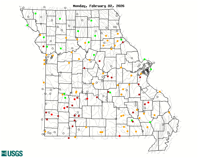
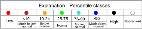
River and Stream Flow Conditions: |
|||||||||||||||||||||||||||||||||||
|
Streamflows are generally at or above normal across much of the region due to recent beneficial rainfall. The Missouri River at Hermann (22nd percentile) and the Middle Fabius River at Ewing (17th percentile) are the exceptions.
|
Hourly and forecast river stages out to 90 days can be found at the National Weather Service's (NWS) Advanced Hydrologic Prediction Service (AHPS) web page: https://water.weather.gov/ahps2/index.php?wfo=lsx Additional Current stream and river stages may be viewed at the following USGS Web Site: |
||||||||||||||||||||||||||||||||||
|
Fire Danger Hazards: |
|||||||||||||||||||||||||||||||||||
|
The current KBDI: Central Missouri: LOW Recent beneficial rainfall has helped alleviate the concern for wild fires. However, parts of southwest Missouri remain more vulnerable than usual due to the persistent dry conditions.
|
The Keetch-Byram Drought Index (KBDI) is a drought index that is specifically related to fire potential. The KBDI is broken into four categories which indicate the susceptibility of ground fuels to fire danger. Below are the four categories and a brief description of each.
KBDI and Dead Fuel Moisture data can be found on the Wildland Fire Assessment System (WFAS) web site at: |
||||||||||||||||||||||||||||||||||
|
Precipitation/Temperature Outlooks: |
|||||||||||||||||||||||||||||||||||
|
The outlook for the next two weeks favors near normal for both temperatures and precipitation.
|
For updated temperature and precipitation probabilities consult the following Climate Prediction Center (CPC) Web Sites: |
||||||||||||||||||||||||||||||||||
|
Questions or Comments: |
|||||||||||||||||||||||||||||||||||
|
If you have any questions or comments about this information please contact:
National Weather Service - St. Louis
Our most recent Drought Information Statement (DGTLSX) is available at:
https://www.crh.noaa.gov/product.php?site=LSX&product=DGT&issuedby=LSX
|
Other Contacts: Missouri State Climatologist: Illinois State Climatologist:
|
||||||||||||||||||||||||||||||||||
|
Acknowledgements: |
|||||||||||||||||||||||||||||||||||
|
The drought monitor is a multi-agency effort involving NOAA’s national weather service and national climatic data center, the USDA, state and regional center climatologists and the national drought mitigation center. Information for this statement has been gathered from NWS and FAA observation sites, cooperative and volunteer observations, USDAFS, the USDA and USGS.
|
Related Websites : NWS - https://www.weather.gov/lsx CPC - http://www.cpc.ncep.noaa.gov U.S. Drought Portal: USGS - https://water.usgs.gov/ COE - https://www.mvr.usace.army.mil/ Missouri DNR Drought Page:
|
||||||||||||||||||||||||||||||||||
|
|
|||||||||||||||||||||||||||||||||||


 Weather Story
 Weather Map
 Local Radar