PATH
After lingering as a broad area of low pressure in the western Caribbean Sea for four days, a tropical depression formed just after midnight EDT on October 13 and became tropical storm Irene in the northwest Caribbean later that morning. Irene moved north across western Cuba on October 14 and strengthened to hurricane intensity early on October 15 in the Straits of Florida. It then made its first landfall in south Florida in the lower Florida Keys around 9 am EDT October 15. After crossing Florida Bay, the center made landfall on the peninsula near Cape Sable around 4 pm EDT October 15 as a Category One intensity hurricane. It moved northeast across central Miami-Dade and Broward counties before exiting into the Atlantic just after midnight on October 16 near Jupiter in northeast Palm Beach County.
METEOROLOGICAL EFFECTS
Heavy rains and sustained winds of tropical storm force caused widespread flooding and power outages in the metropolitan areas of Miami-Dade, Broward, and Palm Beach counties. The effects were similar, although somewhat more widespread, than those experienced in Tropical Storm Gordon in November 1994 and were reminiscent of the wet hurricanes in the 1930s and 1940s.
Rainfall totals in southeast Florida ranged from 6 to 17 inches with many areas getting 10 to 15 inches. The greatest reliable amount reported was 17.45 inches at Boynton Beach. The highest sustained wind over land was 60 mph at Miami Beach with many readings from 40 to 55 mph. Fowey Rocks Light reported sustained winds of 66 mph while the Miami NWS doppler radar estimated areas of sustained hurricane force winds in the Atlantic Ocean just off the southeast Florida coast. Among the highest recorded gusts were readings of 93 mph near Belle Glade, 85 mph at Homestead Air Reserve Base, 84 mph at Fowey Rocks Light, 74 mph at Turkey Point, and 70 mph at Miami International Airport. The lowest barometric pressure on the south Florida peninsula was 989.9 mb at Opa Locka Airport. Storm surge and beach erosion were minimal.
Four tornadoes (3 of F0 intensity and 1 of F1 intensity) touched down in Broward and Palm Beach counties, injuring 3 persons. Several other areas of localized wind damage were reported, especially near the southeast shore of Lake Okeechobee, and were likely attributable to convective downbursts.
CASUALTIES AND DAMAGE
There were no direct deaths from Irene, but eight persons died in the aftermath. Five were electrocuted by downed power lines, including three persons from one family. Three persons drowned in vehicle-related accidents. Damage in southeast Florida, mainly from flooding is estimated at $600 million which includes $335 million in agricultural losses. An estimated 700,000 customers lost electricity. Flooding in a few residential lasted for a week displacing several hundred persons and isolating thousands more.
Other long-term ecological repercussions may be experienced from the flooding rains such as the effects of high water on Everglades' hammocks, and the effects of excessive fresh-water runoff on brackish estuaries.
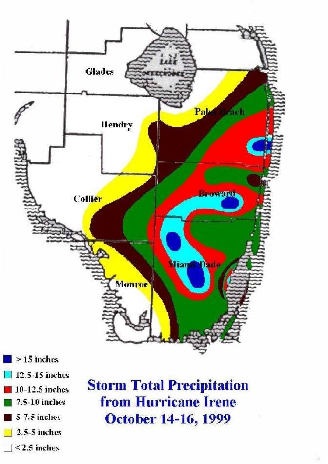
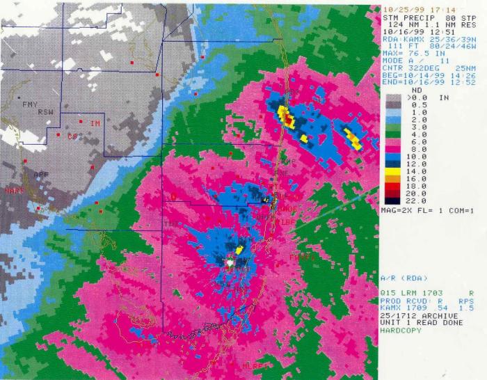
Above is a graphic of the Storm Total Precipitation from Hurricane Irene, as measured by various rain gages and observers. Below is the Storm Total Precipitation as depicted by the Miami WSR-88D doppler weather radar. The rainfall maxima, and overall shape of the precipitation pattern, corresponds well between the two graphics.
Below is a table of selected Storm Total rainfall amounts from around south Florida during Hurricane Irene. The observations are from "official" National Weather Service gages, from co-op observer sites, and from South Florida Water Management District gages.
| LOCATION | COUNTY | PRECIPITATION |
| Boynton Beach | Palm Beach | 17.45 inches |
| Cooper City | Broward | 15.43 inches |
| West Pembroke Pines | Broward | 14.85 inches |
| Homestead ARB | Miami-Dade | 14.57 inches |
| Saga Bay | Miami-Dade | 13.89 inches |
| South Miami | Miami-Dade | 13.50 inches |
| Fort Lauderdale Dixie Water Plant | Broward | 13.38 inches |
| Hollywood Waste Water Plant | Broward | 13.13 inches |
| Homestead General Airport | Miami-Dade | 12.03 inches |
| Plantation | Broward | 11.70 inches |
| Tamiami Trail/Krome Avenue | Miami-Dade | 11.60 inches |
| Miami International Airport | Miami-Dade | 10.99 inches |
| Palm Beach International Airport | Palm Beach | 10.88 inches |
| Everglades/U.S. 27 | Broward | 10.38 inches |
| Lauderdale Lakes | Broward | 9.73 inches |
| El Portal | Miami-Dade | 9.53 inches |
| Miami Beach-Beach Patrol HQ | Miami-Dade | 9.49 inches |
| Pompano Beach | Broward | 9.34 inches |
| Lake Worth | Palm Beach | 9.17 inches |
| Biscayne Bay and 320th Street | Miami-Dade | 8.95 inches |
| Weston | Broward | 8.79 inches |
| N. Dade Norwood Water Plant | Miami-Dade | 8.35 inches |
| North Miami Beach | Miami-Dade | 8.25 inches |
| West Boca Raton | Palm Beach | 7.80 inches |
| Opa Locka Airport | Miami-Dade | 7.60 inches |
| North Palm Beach | Palm Beach | 7.55 inches |
| Sawgrass Mills | Broward | 7.41 inches |
| Leisure City | Miami-Dade | 7.08 inches |
| Jupiter | Palm Beach | 6.44 inches |
The following are wind speeds recorded by NWS and South Florida Water Management District recorders. They are standard highest 1-minute average wind speeds (sustained winds), followed by peak wind gusts.
| LOCATION | MAXIMUM SUSTAINED WIND | PEAK WIND GUST |
| Belle Glade | 68 mph | 93 mph |
| 20-25 mi SSW of Clewiston | 67 mph | 91 mph |
| Fowey Rocks Light C-MAN near Key Biscayne |
66 mph | 84 mph |
| Middle of Lake Okeechobee | 65 mph | 81 mph |
| North end of Lake Okeechobee | 64 mph | 79 mph |
| Miami Beach | 60 mph | Unknown |
| South end of Lake Okeechobee | 58 mph | 75 mph |
| Turkey Point Nuclear Plant | 58 mph | 74 mph |
| National Weather Service Miami | 57 mph | 68 mph |
| 25 mi W of West Palm Beach | 56 mph | 68 mph |
| West end of Lake Okeechobee | 53 mph | 65 mph |
| Kendall-Tamiami Airport | 52 mph | 69 mph |
| Homestead Air Reserve Base | 48 mph | 85 mph |
| Lake Worth C-MAN | 48 mph | 61 mph |
| Miami International Airport | 47 mph | 70 mph |
| Pompano Beach Airport | 46 mph | 58 mph |
| Fort Lauderdale Executive Airport | 46 mph | 58 mph |
| Opa Locka Airport | 45 mph | 56 mph |
| Loxahatchee National Wildlife Refuge 25 mi W Boca Raton |
43 mph | 71 mph |
| 35 mi W Boca Raton | 43 mph | 57 mph |
| Palm Beach International Airport | 43 mph | 61 mph |
| North Perry Airport | 43 mph | 58 mph |
| Off Krome Avenue N of Homestead | 36 mph | 57 mph |
| 20-25 mi S of Clewiston | 35 mph | 78 mph |
| La Belle | 30 mph | 49 mph |

