
Dangerous heat will expand from the Gulf Coast into the Southern Plains and Desert Southwest through week's end. Additional extreme heat impacting the Pacific Northwest will shift to the northern Plains by the weekend. Tropical Storm Bertha is expected to continue to impact portions of the northwestern Gulf Coast from south central Louisiana to the upper Texas coast today. Read More >
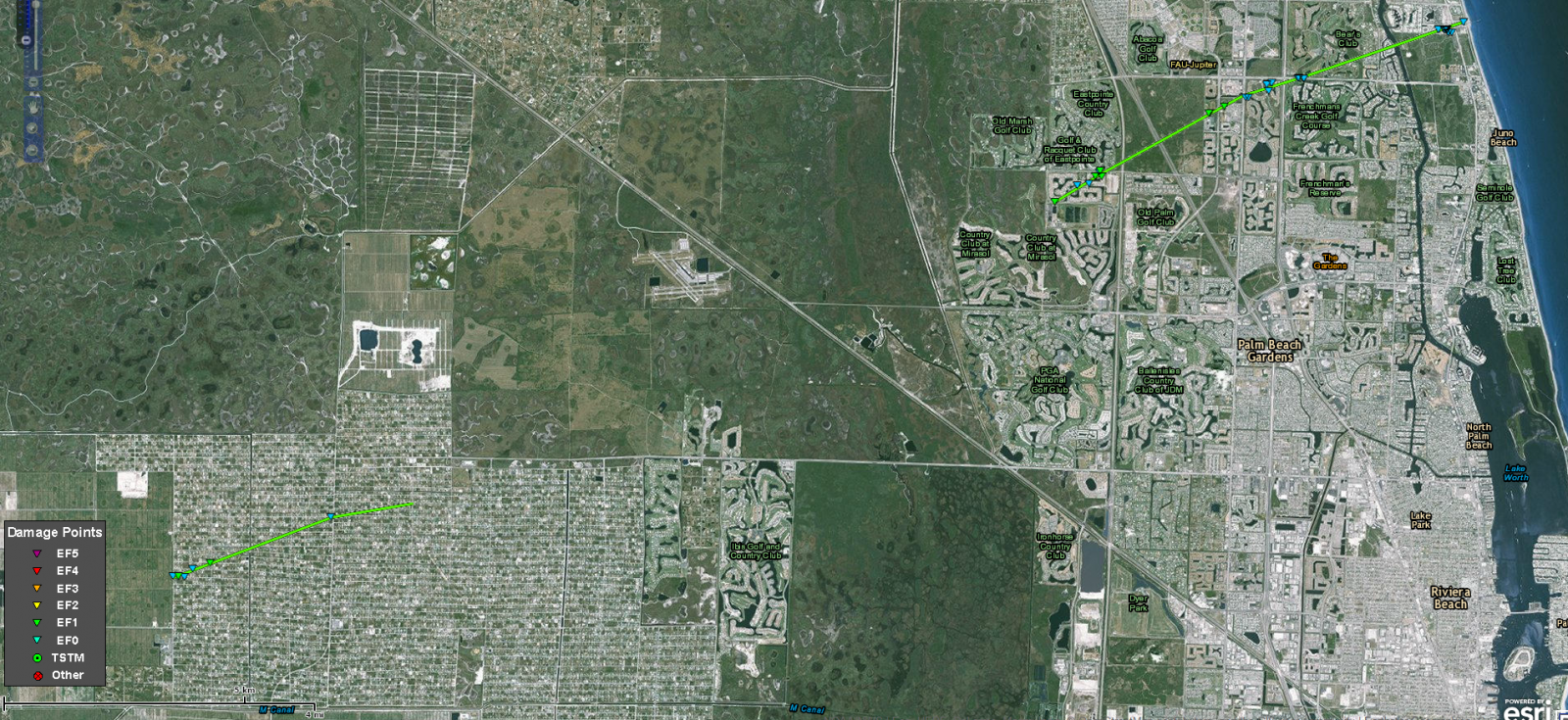
PALM BEACH COUNTY TORNADO

Rating:                 EF-0 TO EF-1
Estimated peak wind:    90 mph
Path length (statute):  18 miles (discontinuous)
Path width (maximum):   130 yards
Fatalities:             0
Injuries:               0

Start date:             JAN 23 2017
Start time:             AROUND 1:25AM EST
Start location:         LOXAHATCHEE, FL
Start lat/lon:          26.7899/-80.3273

End date:               JAN 23 2017
End time:               AROUND 1:47AM EST
End location:           JUNO BEACH, FL
End_lat/lon:            26.8931/-80.057

Survey summary: Additional information from storm spotters suggest
the first touchdown occurred in northwest portion of The Acreage/
Loxahatchee and continued on the ground for about 3 miles before
lifting. Damage in The Acreage consisted mainly of snapped pine trees
and large branches, intensity EF-0. The track continued in the
Mirabella neighborhood of Palm Beach Gardens west of Florida Turnpike
between PGA Boulevard and Donald Ross Road, then followed a
discontinuous path ENE across Palm Beach Gardens to Juno Beach where
it moved offshore at the Juno Beach Pier.

EF-1 damage was concentrated mainly in the Mirabella neighborhood and
east of I-95 at The Benjamin School. A few homes had tiles removed in
Mirabella, causing broken windows from flying debris. At The Benjamin
School Upper Campus, a full set of metal bleachers was blown across
a football field for at least 50 yards, with some of the pieces of
the bleachers landing in an adjacent wooded area well over 100 yards
away. Debris from this location ended up as far away as Dwyer High
School about 500 yards east from the original location. At Dwyer High
School, the tornadic winds as well as flying debris broke windows,
damaged a softball field and caused a small hole in the ceiling
over a classroom in the school`s main building. Damage estimates at
Dwyer High School are in the $500,000 to $1 Million range.

Most of the remainder of the damage along the path was rated EF-0 and
consisted mainly of broken tree branches, uprooted trees and damage to
mobile homes in Juno Beach. The tornado moved offshore at the Juno Beach
Pier around 145 AM where an unconfirmed wind gust of 87 mph was recorded.
A piece of the railing at the pier was removed, likely from the winds
of the tornado.

Map of the Palm Beach County Tornado Damage Path
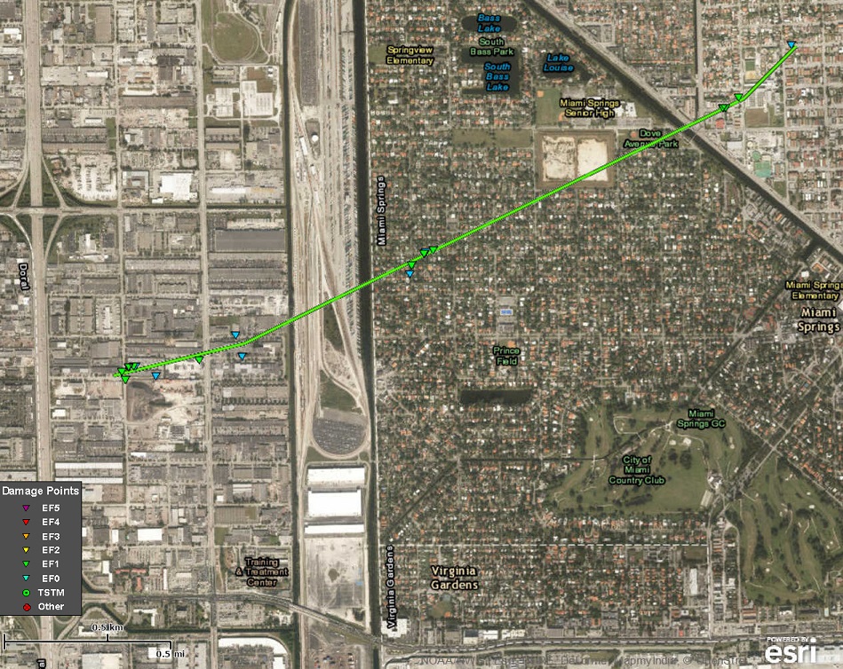
MIAMI SPRINGS-HIALEAH TORNADO

Rating:                 EF-0 TO EF-1
Estimated peak wind:    107 mph
Path length (statute):  2.3 miles
Path width (maximum):   123 yards
Fatalities:             0
Injuries:               0

Start date:             JAN 23 2017
Start time:             AROUND 3:45AM EST
Start location:         MIAMI SPRINGS, FL
Start lat/lon:          25.8192/-80.3176

End date:               JAN 23 2017
End time:               AROUND 3:48AM EST
End location:           HIALEAH, FL
End_lat/lon:            25.8334/-80.2853

Survey summary: The survey team has tentatively verified that a
tornado touched down in the Miami Springs area just east of the
Palmetto Expressway, between NW 55th St and NW 48th St. The tornado
took a path to the east northeast, causing damage in multiple
locations in Miami Springs, and then Hialeah, near the water
plant. The damage path ended around the intersection of W 2nd Ave
and W 12th St. During the time it was on the ground, the damage
indicated that the tornado varied in strength between an EF-0 and
an EF-1.

Map of the Miami Springs-Hialeah Tornado Damage Path
EF scale: The Enhanced Fujita scale classifies
tornadoes into the following categories.

EF0...weak......65 to 85 mph
EF1...weak......86 to 110 mph
EF2...strong....111 to 135 mph
EF3...strong....136 to 165 mph
EF4...violent...166 to 200 mph
EF5...violent...>200 mph*

Note:
The information in this statement is preliminary and subject to
change pending final review of the events and publication in
NWS Storm Data.

