Miami - South Florida
Weather Forecast Office
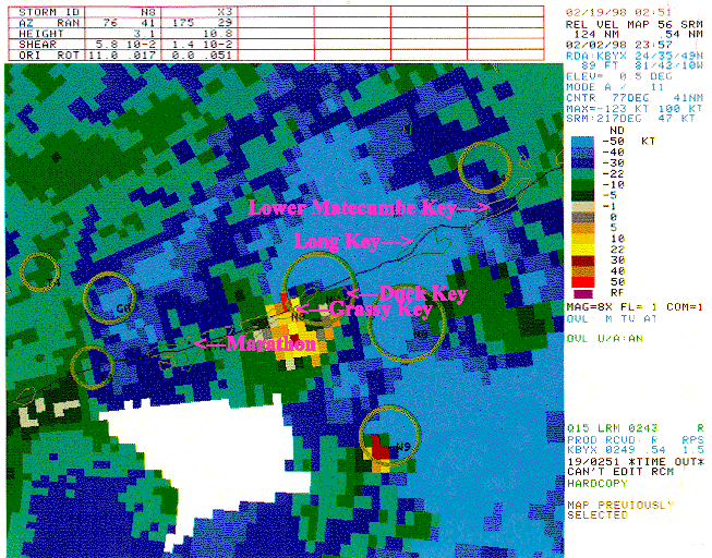
This radar image was taken from the Key West (KBYX) Doppler radar at 6:57 pm February 2, 1998. This was about 5 minutes after the F1 tornado had passed through Grassy Key causing moderate damage. The image is a Storm Relative Velocity Map with two very strong signatures noted... one over Grassy Key and another still over the Florida Straits south of Duck Key. These and subsequent strong thunderstorms not only damaged structures but uprooted trees and knocked down power lines. Most of the lower and middle Keys were without power from that evening until late the following day.
CURRENT HAZARDS
Submit a Storm Report
Outlooks
Graphical Hazardous Weather Outlook
Self Briefing Page
National Hazards
Tropics / Hurricanes
Local Storm Reports
CURRENT WEATHER
Surface Observations
Satellite
Observed Precipitation
MesoAnalysis
Rivers / Lakes
Latest Sounding
Lake Okeechobee
PAST WEATHER
Recent Rainfall
Tropical Cyclone Reports
Past Events
FORECASTS
Forecast Discussion
Tropical Weather
Probabilistic Page
Heat Page
Cold Weather Page
Marine Weather
Fire Weather
Beach Forecast
Aviation Weather
Probabilistic QPF
Hourly Forecasts
Activity Planner
Graphical Forecast
International Weather
RADAR IMAGERY
National
Miami Radar
Key West Radar
Across Florida
CLIMATE
Local Climate Info
More Local Climate Info
Climate Graphs
US Dept of Commerce
National Oceanic and Atmospheric Administration
National Weather Service
Miami - South Florida
11691 SW 17th Street
Miami, FL 33165
305-229-4522
Comments? Questions? Please Contact Us.

