|
|||||
|
Isaac began as a tropical depression east of the Lesser Antilles on the morning of August 21, 2012, reaching tropical storm strength later that afternoon. Isaac moved west across the Lesser Antilles on August 22nd and into the eastern Caribbean Sea where it passed south of Puerto Rico. The center of Tropical Storm Isaac passed over western sections of Hispaniola and eastern Cuba on Friday night, August 24th and Saturday, August 25th as it moved northwest. Isaac then moved west-northwest through the Straits of Florida on Sunday, August 26th, with the center passing across the lower Keys late that afternoon. Isaac continued on a west-northwest track over the southeast Gulf of America Sunday through Monday, August 27th.
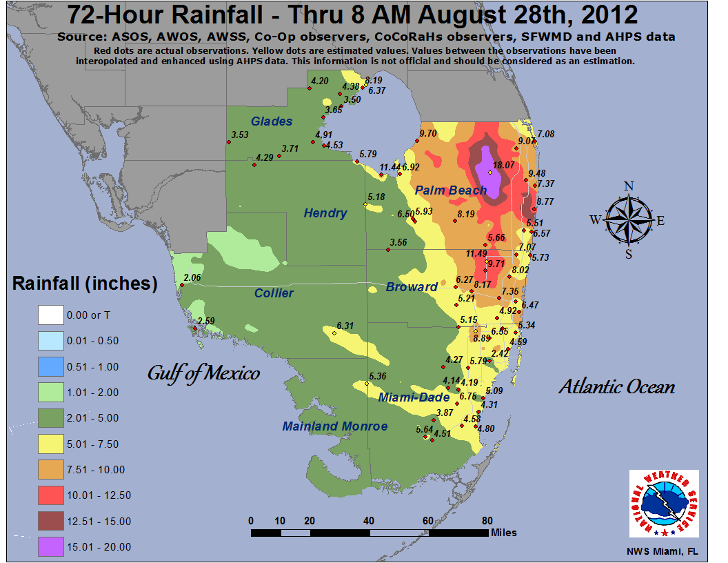
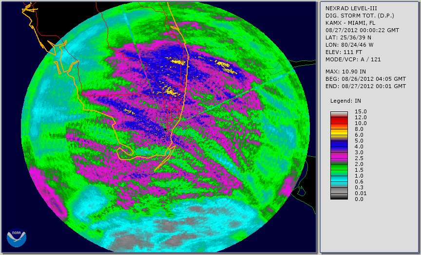
Rainfall/Flooding: A Flood Watch was issued at 459 AM Sunday, August 26th for all of mainland south Florida due to the potential for significant flooding. As the center of Isaac passed by the lower Keys late Sunday afternoon, a series of heavy rain bands formed over the Atlantic and began to move onshore southeast Florida Sunday evening. The bands of heavy rains and squalls continued through the night and into early Monday morning. The heaviest of the rain bands concentrated over Palm Beach and Broward counties, producing between 10 and 13 inches of rain mainly west of the Florida Turnpike from The Acreage south to northern metro Broward County. Other rain bands developed during the day on Monday over the same area in eastern Palm Beach County that received the heavy rainfall Sunday night (Figure 1). Rainfall amounts from this rainband yielded an additional one to three inches. The final result was an area of 10+ inches of rain across roughly one-third of Palm Beach County stretching from Jupiter Farms south to Boca Raton, then into northern metro Browad County from Coral Springs to Lauderhil. Maximum rain amounts were both measured and estimated in the 15 to 20 inches range across the Wellington and The Acerage communities (Figure 3). These rains led to severe flooding, with the western communities of metro Palm Beach County hardest hit. Several homes were flooded and many streets were left impassable (Figures 4, 5, and 6). Neighborhoods were stranded by several feet of water as a result of excessive rainfall overtopping canals. Damage was estimated at over $8 million directly related to the flooding. The following table contains the top 10 rainfall reports across south Florida from Isaac:
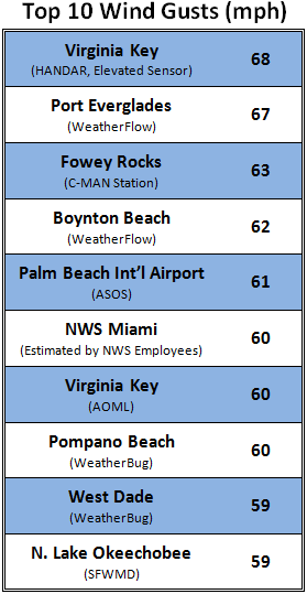
Another primary concern from Isaac was the potential for significant storm tide and coastal flooding. The eventual track of Isaac lessened the impact for southwest Florida; nevertheless coastal flooding was observed along the coast of Collier County. After an especially low tide from strong winds pushing water away from the coast Sunday afternoon, southerly winds on the back side of Isaac pushed water rapidly back toward the coast on Monday. By the time of high tide around midday on Monday, tides had risen as much as six feet from the previous day's low tide. Up to three feet of tidal inundation occurred along the Collier County coast from Everglades City to Chokoloskee, flooding roads and leaving people stranded (Figures 7 and 8). Major beach erosion and minor coastal flooding also occurred in Naples, with total damage in Collier County estimated at $6 million. Wind: Although flooding was the main story that resulted from Tropical Storm Isaac's track near south Florida, many areas experienced high winds as well. The following table contains peak wind gusts across south Florida from Isaac:
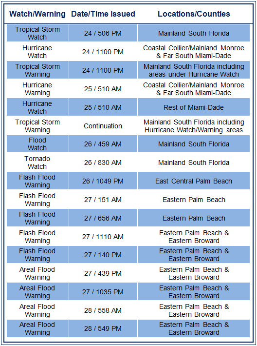
From the initial issuance of tropical storm watches for all of mainland South Florida Friday evening, August 24th, flooding was emphasized as a primary concern. Following are impact statements taken from several Tropical Cyclone Local Statements issued by the NWS Weather Forecast Office (WFO) in Miami. - From the Tropical Cyclone Local Statement issued at 612 PM August 24th: "THERE IS ALSO THE CONCERN FOR SIGNIFICANT FLOODING ACROSS PORTIONS OF SOUTH FLORIDA LATE IN THE WEEKEND INTO MONDAY AS THE SYSTEM APPROACHES AND MOVES ACROSS THE AREA." "THERE IS A GENERAL CONCERN FOR AT LEAST MINOR COASTAL FLOODING MAINLY ALONG THE EXTREME SOUTHEAST AND SOUTHERN MIAMI DADE AND THE SOUTHWEST FLORIDA COASTS." - As Isaac approached South Florida and potential impacts became a little more clear, the following statements were included in the Tropical Cyclone Local Statement issued at 1220 PM Saturday, August 25: Rainfall/Flooding Statement: "THERE IS ALSO THE CONCERN FOR SIGNIFICANT FLOODING ACROSS PORTIONS OF SOUTH FLORIDA SUNDAY THROUGH MONDAY AS THE SYSTEM APPROACHES AND MOVES ACROSS THE AREA. TOTAL RAINFALL AMOUNTS OF 5 TO 10 INCHES ARE CURRENTLY FORECAST THROUGH MONDAY. THERE IS THE POTENTIAL FOR MUCH HIGHER AMOUNTS IF RAIN BANDS TRAIN REPEATEDLY OVER THE SAME AREA AS ISAAC MOVES ACROSS THE AREA. A FLOOD WATCH WILL LIKELY BE NEEDED FOR ALL OF SOUTH FLORIDA BY SUNDAY. Collier County Storm Tide Impact Statement: AS TROPICAL STORM ISAAC APPROACHES THE COAST...THERE IS AN INCREASING CHANCE FOR COMBINED STORM SURGE AND ASTRONOMICAL TIDE WATERS UP TO 7 FEET ABOVE MEAN SEA LEVEL WITHIN AREAS CLOSER TO THE COAST...RESULTING IN WORST CASE FLOOD INUNDATION OF 5 TO 7 FEET ABOVE GROUND LEVEL SOMEWHERE WITHIN THE SURGE ZONE. THE LOCATIONS WITH THE GREATEST FLOODING POTENTIAL INCLUDE AREAS ALONG THE IMMEDIATE GULF COAST SOUTH AND WEST OF TAMIAMI TRAIL IN COLLIER COUNTY DOWN TO THE EVERGLADES CITY AREA. ON THE CURRENT FORECAST TRACK...STORM SURGE IS LIKELY TO BE LOWER THAN THE VALUES ABOVE...HOWEVER...ANY DEVIATION IN TRACK TO THE EAST AND OR AN INCREASE IN STORM INTENSITY OR SIZE COULD RESULT IN AT LEAST THIS SURGE POTENTIAL IF NOT HIGHER. MAIN TIMING CONCERN FOR SURGE ALONG GULF COAST WILL BE ON MONDAY. AGGRESSIVE PREPARATIONS SHOULD BE MADE FOR THE THREAT OF MAJOR COASTAL FLOOD DAMAGE FROM SEA WATER. IF REALIZED...EXPECT LARGE AREAS OF DEEP INUNDATION WITHIN THE FLOOD ZONE. SEVERE BEACH EROSION. SEVERAL SECTIONS OF NEAR-SHORE ROADS WASHED OUT AND/OR LOW-LYING ESCAPE ROUTES SEVERELY FLOODED..." - The Local Statement issued at 859 AM Sunday, August 26th continued to place emphasis on the flood threat: Rainfall/Flooding Statement: "THERE IS ALSO THE CONCERN FOR SIGNIFICANT FLOODING ACROSS PORTIONS OF SOUTH FLORIDA TODAY THROUGH MONDAY. TOTAL RAINFALL AMOUNTS OF 4 TO 8 INCHES ARE CURRENTLY FORECAST THROUGH MONDAY. THERE IS THE POTENTIAL FOR MUCH HIGHER AMOUNTS IF RAINBANDS TRAIN REPEATEDLY OVER THE SAME AREA AS ISAAC PASSES SOUTH OF THE AREA..." Collier County Storm Tide Impact Statement: "AS TROPICAL STORM ISAAC APPROACHES THE COAST...THERE IS A CHANCE FOR COMBINED STORM SURGE AND ASTRONOMICAL TIDE WATERS UP TO 7 FEET ABOVE MEAN SEA LEVEL WITHIN AREAS CLOSER TO THE COAST... RESULTING IN WORST CASE FLOOD INUNDATION OF 4 TO 6 FEET ABOVE GROUND LEVEL SOMEWHERE WITHIN THE SURGE ZONE. THE LOCATIONS WITH THE GREATEST FLOODING POTENTIAL INCLUDE AREAS ALONG THE IMMEDIATE GULF COAST SOUTH AND WEST OF TAMIAMI TRAIL IN COLLIER COUNTY DOWN TO THE EVERGLADES CITY AREA... AGGRESSIVE PREPARATIONS SHOULD BE MADE FOR THE THREAT OF MAJOR COASTAL FLOOD DAMAGE FROM SEA WATER. IF REALIZED...EXPECT AREAS OF DEEP INUNDATION WITHIN THE FLOOD ZONE. SEVERE BEACH EROSION. SEVERAL SECTIONS OF NEAR-SHORE ROADS WASHED OUT AND/OR LOW-LYING ESCAPE ROUTES SEVERELY FLOODED..." - From 548 AM Monday, August 27th local statement: Rainfall/Flooding Statement: "THE MOST VULNERABLE LOCALES WILL BE ACROSS THE WEST PALM BEACH METROPOLITAN AREA, WHERE THE HEAVIEST RAINS OCCURRED OVERNIGHT WITH RAINFALL AMOUNTS SINCE YESTERDAY OF 5 TO 10 INCHES. A FLASH FLOOD WARNING CONTINUES FOR EASTERN PALM BEACH COUNTY UNTIL 8 AM THIS MORNING. THERE IS THE POTENTIAL FOR FLASH FLOODING ACROSS THE REST OF SOUTH FLORIDA IF HEAVY AND PERSISTENT RAINBANDS DEVELOP. LISTEN FOR POSSIBLE FLOOD WARNINGS FOR YOUR LOCATION...AND BE READY TO ACT IF FLOODING RAINS OCCUR." Collier County Storm Tide Impact Statement: "TOTAL WATER LEVELS ABOVE THE GROUND CAN STILL POTENTIALLY REACH 1 TO 3 FEET FROM MARCO ISLAND TO EVERGLADES CITY...WHICH COULD RESULT IN MINOR TO LOCALLY MODERATE COASTAL FLOODING. CONDITIONS WILL IMPROVE LATER TODAY. THE MAIN THREAT WILL BE WHEN THE WINDS TURN ONSHORE LATER TODAY. THIS THREAT HAS CONTINUED TO DIMINISH SINCE YESTERDAY. MODERATE SURF LATER TODAY COULD LEAD TO MINOR TO MODERATE BEACH EROSION ALONG WITH RIP CURRENTS." Following is a list of watches and warnings issued by WFO Miami:
NWS Miami Post-Storm Report on Isaac (full set of data)
|
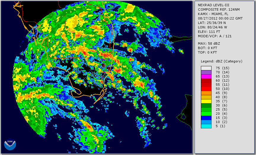
Figure 1: Tropical Storm Isaac radar animation from Miami WSR-88D from August 26, 2012 at 8 PM to August 27, 2012 at 7:30 PM. (Click the image to view a larger version of the animation)
Figure 2: 72-hour total rainfall accumulation map from Tropical Storm Isaac. (Download in KML format)
Figure 3: Miami WSR 88-D estimated storm total precipitation movie from August 26, 2012 at 8 PM to August 27, 2012 at 7:30 PM. (Click the image to view movie)
Figure 4: Extensive flooding in the
Figure 5: Water mark seen alongside a building in the town of Loxahatchee due to extensive flooding from Tropical Storm Isaac.
Figure 6: 60th Lane North just north of Lion Country Safari in Palm Beach County flooded due to Tropical Storm Isaac.
Figure 7: Storm tide flooding in Goodland. (photo courtesy of Naples News)
Figure 8: Storm tide flooding in Everglades City (photo courtesy Collier County Sherriff's Office). |
||||