|
|||||
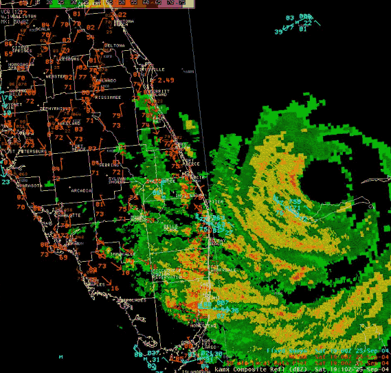
| Hurricane Jeanne formed from a tropical depression just east of the Leeward Islands on September 13. She moved across Puerto Rico and Hispaniola then turned north into the Atlantic and became a hurricane on September 20. Jeanne made a clockwise loop for three days in the Atlantic north of Hispaniola before moving west northwest. It strengthened to a Category 3 Hurricane while over the northwest Bahamas and then make landfall around 11 P.M., September 25 near the south end of Hutchinson Island, nearly coincident with the landfall point of Hurricane Frances nearly three week before. The 40-mile diameter eye was not quite as large as Frances, but the southern eyewall again affected northeast Palm Beach County. After landfall Jeanne initially moved along a track similar to Frances, just north of Lake Okeechobee as it weakened to a tropical storm then it turned to the northwest and moved over the northwest Florida Peninsula. Although slightly smaller and stronger then Hurricane Frances, winds and pressures over southeast Florida were remarkably similar to Frances. Unfortunately, the ASOS at West Palm Beach International Airport quit sending data during the height of the hurricane. Sustained tropical storm-force winds likely occurred over most of Palm Beach and northeast Glades counties and portions of Broward, Hendry and Collier counties. Although no sustained hurricane-force winds were officially observed in any of the six south Florida counties, portions of northern Palm Beach County mostly likely experienced them. A South Florida Water Management District (SFWMD) instrument in the Martin County portion of Lake Okeechobee measured a 15-minute sustained wind of 79 mph with a peak gust of 105 mph. In metropolitan Palm Beach the highest official sustained wind speed was 60 mph with a peak gust of 94 mph from the C-MAN station at Lake Worth Pier. An unofficial peak wind gust of 125 mph was measured in West Palm Beach at the Solid Waste Treatment Plant. In Glades County near the western shore of Lake Okeechobee the highest sustained wind measured at a SFWMD instrument was 68 mph with a peak gust of 94 mph. Near Clewiston the highest measured sustained wind was 31 mph with a peak wind gust of 72 mph from a SFWMD instrument. The highest measured sustained wind in Broward County was 46 mph with a peak wind gust of 67 mph from the ASOS site at Pompano Beach Airpark. At Fort Lauderdale-Hollywood International Airport the ASOS site measured a maximum sustained wind of 40 mph with a peak gust of 56 mph. In Miami-Dade County a maximum sustained wind of 49 mph with a peak gust of 59 mph was measured at the C-MAN station at Fowey Rocks Light with sustained winds of 26 mph and gusts to 36 mph at Miami International Airport ASOS. At the Naples Municipal Airport, the ASOS maximum sustained wind was measured at 33 mph with a peak gust of 45 mph. The lowest barometric pressure of 960.4 mb was measured at a SFWMD site in the Martin County portion of Lake Okeechobee. A SFWMD gage measured a maximum storm-total rainfall amount of 10.22 inches over the eastern portion of Lake Okeechobee. A SFWMD gage about four miles west of West Palm Beach International Airport measured 9.10 inches with 8.79 inches of that occurring in a 24-hour period. At Moore Haven, 5.99 inches of rain was measured. Widespread storm-total amounts of one to four inches occurred in most of southeast and interior south Florida with Miami-Dade County and Collier County averaging one half to one inch. Mostly minor rainfall flooding was observed except locally severe in Palm Beach Gardens, Jupiter and in the farmlands of western Palm Beach County. The estimated maximum storm surge ranged from two to four feet along the northeast Palm Beach Coast to one to two feet along the northeast Broward Coast. Within the confines of the Herbert Hoover Dike, water levels on Lake Okeechobee fluctuated up to seven feet above and below normal causing severe flooding of some marinas. Beach erosion was moderate in Palm Beach and minor in Broward and Miami-Dade counties. There were no confirmed tornadoes in South Florida. There were no known direct deaths but four persons died in the aftermath. An unknown number of injuries occurred. Property damage from storm surge and winds at the coast occurred to condos, marinas, piers, seawalls, bridges and docks, as well as to boats and a few coastal roadways. Inland wind damage to building roofs, mobile homes, trees, power lines, signs, and outbuildings occurred over mainly over Palm Beach County and portions of eastern Glades and Hendry counties. A preliminary damage estimate for Jeanne in southeast Florida is $330 million, including $260 million in Palm Beach, $50 million in Broward and $10 million in Miami-Dade. Agricultural Damage in Palm Beach County was estimated at $30 million. Florida Power and Light reported outages occurred to 591,300 customers in Palm Beach, 165,900 in Broward, 25,100 in Miami-Dade, 5,200 in Collier, 3,000 in Hendry and 1,500 in Glades. An estimated 12,534 persons sought refuge in public shelters in Palm Beach County. |
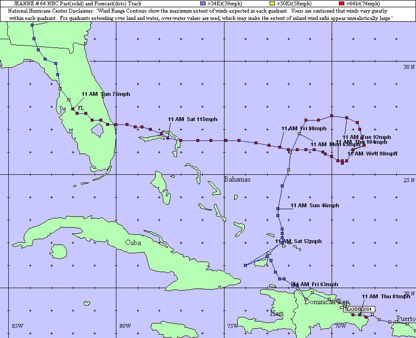 Track Map 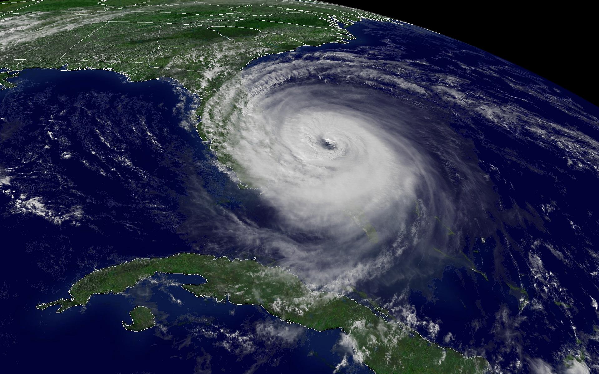 Satellite Image taken at 3:15 p.m. EDT, Sept. 25, 2004. 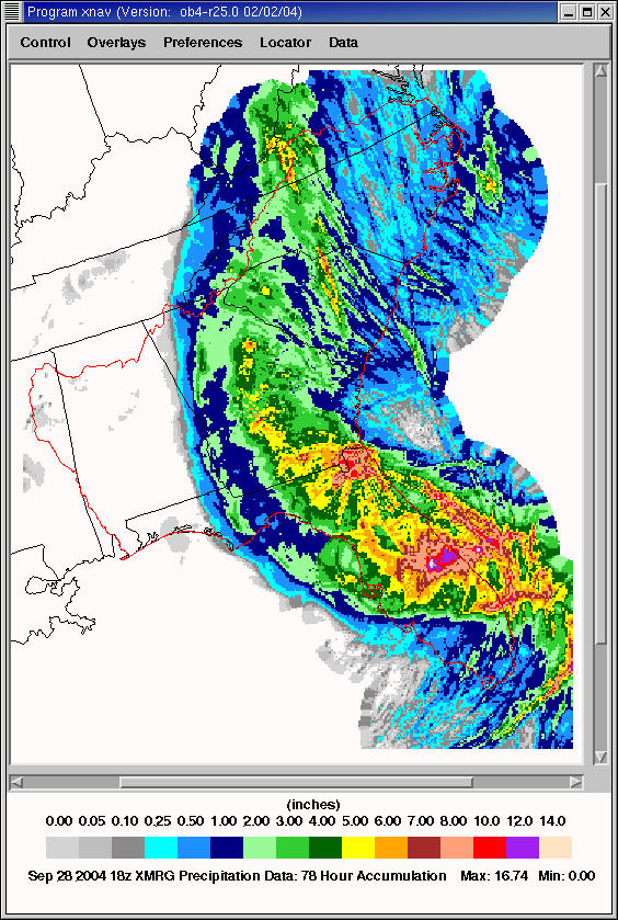 Radar derived storm total rainfall estimates for Hurricane Jeanne. 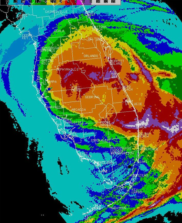 Storm total rainfall estimates from local Florida radars. 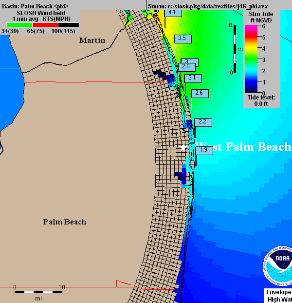 Numerical model simulation of predicted storm surge. Because Jeanne's landfall occurred around midnight, which was close to the time of low tide (-0.5 ft. MSL), observed storm tide was about a half foot lower than indicated above. 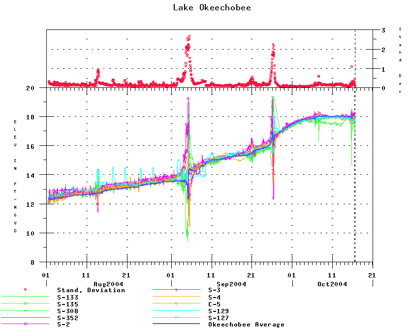 South Florida Water Management District (SFWMD) measurements of lake level decpicted storm surge from Hurricane Jeanne. View map of SFWMD Lake Okeechobee observing sites. |
||||
Additional Information Radar animation of Hurricane Jeanne. (CAUTION: file is large (3 mb), and will take a while to download) Wind swath map created by the NOAA Atlantic Oceanic and Marine Laboratory (AOML) National Hurricane Center report on Hurricane Jeanne Radar animation of Hurricane Jeanne. (CAUTION: file is large (3 mb), and will take a while to download) Wind swath map created by the NOAA Atlantic Oceanic and Marine Laboratory (AOML) National Hurricane Center report on Hurricane Jeanne |
|||||


