Miami - South Florida
Weather Forecast Office
February 2, 1998 Doppler Radar Images
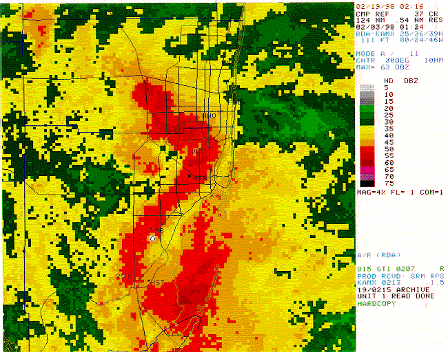
The above radar reflectivity image was taken from the Miami (KAMX) Doppler radarpar at 8:24 pm February 2, 1998 and shows the very strong intensity of the echo pattern overpar the Dade/Broward Metro area. A large well-defined Bow echo of >50 DBZ intensity,par and several embedded areas of >55 DBZ near Opa Locka (OPF), south and west ofpar North Perry Airport (HWO) along the Dade/Broward line in the Pembroke Pines/Miramar area.par The strongest intensity of 63 DBZ is located northwest of North Perry in the Davie/Cooperpar City area of Broward county.
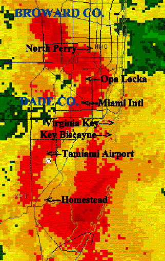
The image below is an enlarged view of the above picture highlighting regions of the metropolitan area.
CURRENT HAZARDS
Submit a Storm Report
Outlooks
Graphical Hazardous Weather Outlook
Self Briefing Page
National Hazards
Tropics / Hurricanes
Local Storm Reports
CURRENT WEATHER
Surface Observations
Satellite
Observed Precipitation
MesoAnalysis
Rivers / Lakes
Latest Sounding
Lake Okeechobee
PAST WEATHER
Recent Rainfall
Tropical Cyclone Reports
Past Events
FORECASTS
Forecast Discussion
Tropical Weather
Probabilistic Page
Heat Page
Cold Weather Page
Marine Weather
Fire Weather
Beach Forecast
Aviation Weather
Probabilistic QPF
Hourly Forecasts
Activity Planner
Graphical Forecast
International Weather
RADAR IMAGERY
National
Miami Radar
Key West Radar
Across Florida
CLIMATE
Local Climate Info
More Local Climate Info
Climate Graphs
US Dept of Commerce
National Oceanic and Atmospheric Administration
National Weather Service
Miami - South Florida
11691 SW 17th Street
Miami, FL 33165
305-229-4522
Comments? Questions? Please Contact Us.

