
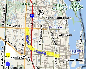
Map of the approximate damage path of the Jupiter tornado Thursday, August 7, 2003 around 510-515 PM EDT
Beginning at approximately 510 PM EDT on Thursday, August 7, 2003, and lasting for about a half hour, the National Weather Service Forecast Office in Miami has determined that it was most likely two separate tornadoes that caused damage in northeast Palm Beach County. The first tornado occurred about 10 minutes after 5 PM EDT and caused scattered F0 or light damage in southeast Jupiter along U.S. Highway 1 and in The Falls subdivision. Winds in an F0 tornado are estimated from 40 to 72 mph. The path length of this tornado was only about 1.5 miles and only about 70 yards wide. Most of the damage was limited to trees and shrubbery (see pictures below) although some ] screens and the metal roof of a shopping center along U.S. 1 were damaged. Apparently this tornado lifted or dissipated as it approached Donald Ross Road because no more damage was found south or southwest of The Falls subdivision until Northlake Boulevard in Palm Beach Gardens.
Map of the approximate damage path of the Palm Beach Gardens-Riviera Beach tornado Thursday, August 7, 2003 around 530-540 PM EDT
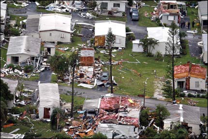
The hardest hit communities were Palm Beach Gardens and Riviera Beach. Latest statistics from the emergency response team show no deaths, 28 injuries (mostly minor), 10 businesses with damage, 33 homes destroyed, 28 homes with major damage, and 236 homes affected. From newspaper reports most of the homes were mobile homes. In addition, several cars and a few tractor trailers were apparently moved or tipped over, light poles were snapped, and many roofs were damaged or torn off. The National Weather Service conducted a preliminary storm survey Thursday night from 830 PM until after 10 PM, and another survey Friday evening from about 5 PM until 7 PM. From all of the evidence considered, including some damage that was very close to F2 damage, WFO Miami classifies the Palm Beach Gardens-Riviera Beach (PBG-RB) tornado as F1 on the Fujita scale, meaning that winds with the tornado(es) were approximately 73 to 112 mph. However, the worst damage was apparently caused by winds near the upper end of that range, i.e., more than 100 mph.
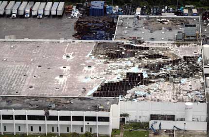
Miami National Weather Service Forecast Office (WFO) meteorologists determined that the main path of the PBG-RB tornado was approximately 1/6 mile (300 yards) wide at its widest point and about 4 miles long. Apparently, the PBG-RB tornado first began causing damage near Northlake Boulevard and Military Trail and moved southeast to A Garden Walk mobile home park where the damage appeared to be in the upper end of F1. The tornado crossed I-95 just north of Blue Heron Boulevard. As it did so, it turned over a truck on I-95 and then moved more easterly into Riviera Beach just north of Blue Heron Boulevard. Along the way it severely damaged the roof of a Pepsi-Cola plant. It continued through neighborhoods in Riviera Beach just north of Blue Heron Boulevard but the damage path was narrower and more F0 until it lifted or dissipated near the intersections of Blue Heron Boulevard and Old Dixie Highway.
The tornadoes that struck northeast Palm Beach County were unusual in that they occurred in August and were associated with a somewhat reverse weather pattern in South Florida in which thunderstorms move into the metro Atlantic coast area in the afternoons (a more normal pattern with easterly flow is for showers and thunderstorms to occur along the metro Atlantic coast in the mornings and very early afternoon) The tornadoes apparently occurred with back-building thunderstorms developing along a sea-breeze convergence line reinforced by thunderstorm outflow boundaries from the southwest and west. The tornadoes also occurred in a very low shear environment, which is unusual because it's harder to get strong tornadoes without shear in the environment. Therefore, in order to produce a tornado in such an environment, everything must come together just right including some interaction with a boundary of some kind. There are almost never cold fronts in South Florida in the summer, and the jet stream is almost always removed far to the north, so boundaries in South Florida in the summer are usually limited to thunderstorm outflow boundaries and the sea breeze convergence line. Even if everything comes together just right...it's still quite unusual to get such a strong tornado producing such damage in August in South Florida!
Radar pictures from the WFO Miami WSR-88D
Damage pictures from the southeast Jupiter area
Damage picture from Palm Beach Gardens (A Garden Walk mobile home park)courtesy The Palm Beach Post web site
Damage pictures from Riviera Beachcourtesy The Palm Beach Post web site
Satellite picture loop
The tornado itself
(More damage pictures and pictures of the tornado itself can be seen by visiting the web sites of South Florida media partners including newspapers and television stations.)
Severe Weather and Forecast Products from WFO Miami
Hazardous Weather Outlook
Zone Forecasts
Tornado Warning
updating Severe Weather Statement 1
updating Severe Weather Statement 2
FLUS42 KMFL 070910 AAA
HWOMIA FLZ063-066>075-071600-
HAZARDOUS WEATHER OUTLOOK
NATIONAL WEATHER SERVICE MIAMI FL
510 AM EDT THU AUG 7 2003
THIS HAZARDOUS WEATHER OUTLOOK IS FOR SOUTH FLORIDA.
.DAY ONE...TODAY
...NUMEROUS THUNDERSTORMS INTERIOR AND EAST COAST THIS AFTERNOON...
...SCATTERED THUNDERSTORMS WEST COAST...
SCATTERED THUNDERSTORMS ARE EXPECTED TO DEVELOP ACROSS ALL OF SOUTH FLORIDA TODAY. THE MOST FAVORED AREAS FOR THUNDERSTORM DEVELOPMENT WILL BE OVER THE INTERIOR PORTIONS OF THE PENINSULA DURING THE EARLY AFTERNOON HOURS...THEN ALONG THE EAST COAST METRO AREAS BY MID TO LATE AFTERNOON. OVER THE WESTERN COLLIER METRO AREA... STORMS SHOULD BE FEWER IN NUMBER... AND OCCUR MAINLY IN THE LATE MORNING TO EARLY AFTERNOON TIME FRAME. FREQUENT CLOUD-TO-GROUND LIGHTNING STRIKES AND WIND GUSTS TO 30 MPH ARE EXPECTED WITH THE STRONGER STORMS. IN ADDITION, VERY LOCALIZED HEAVY RAINS ARE POSSIBLE, AS THE STORMS WILL MOVE QUITE SLOWLY.
NO OTHER HAZARDOUS WEATHER CONDITIONS ARE EXPECTED.
ADDITIONAL INFORMATION AND DETAILED GRAPHICS CAN BE FOUND ON THE NATIONAL WEATHER SERVICE WEB SITE AT MIAMIWEATHER.INFO. FOR INFORMATION IN SPANISH, VISIT OUR WEB SITE AT ELTIEMPOENMIAMI.INFO.
.DAYS TWO THROUGH SEVEN...FRIDAY THROUGH WEDNESDAY
NO HAZARDOUS WEATHER IS EXPECTED AT THIS TIME.
.SPOTTER INFORMATION STATEMENT...
SPOTTER ACTIVATION IS NOT ANTICIPATED.
$$ top
The zone forecast for the metro Atlantic coast
FPUS52 KMFL 071421
ZFPMIA
ZONE FORECASTS FOR SOUTH FLORIDA...UPDATED
NATIONAL WEATHER SERVICE MIAMI FL
1030 AM EDT THU AUG 7 2003
FLZ068-072-074-072100-
BROWARD METROPOLITAN-MIAMI-DADE METROPOLITAN-PALM BEACH EASTERN-
INCLUDING THE CITIES OF...FT LAUDERDALE...MIAMI...WEST PALM BEACH
1030 AM EDT THU AUG 7 2003
.THIS AFTERNOON...MOSTLY SUNNY EARLY THEN INCREASING CLOUDINESS WITH THUNDERSTORMS LIKELY. HIGHS IN THE LOWER 90S. SOUTH WINDS 10 MPH. CHANCE OF RAIN 60 PERCENT.
.TONIGHT...PARTLY CLOUDY. ISOLATED SHOWERS AND THUNDERSTORMS. LOWS IN THE MID 70S...EXCEPT IN THE LOWER 80S ALONG THE COAST. SOUTH WINDS 10 MPH. CHANCE OF RAIN 20 PERCENT.
.FRIDAY...MOSTLY SUNNY IN THE MORNING THEN BECOMING MOSTLY CLOUDY. ISOLATED SHOWERS AND THUNDERSTORMS IN THE MORNING THEN NUMEROUS SHOWERS AND THUNDERSTORMS IN THE AFTERNOON. HIGHS IN THE LOWER 90S. SOUTH WINDS 10 TO 15 MPH BECOMING SOUTHWEST. CHANCE OF RAIN 60 PERCENT.
.FRIDAY NIGHT...PARTLY CLOUDY. SCATTERED SHOWERS AND THUNDERSTORMS IN THE EVENING THEN ISOLATED SHOWERS AND THUNDERSTORMS AFTER MIDNIGHT. LOWS IN THE MID TO UPPER 70S. SOUTHWEST WINDS 10 MPH BECOMING SOUTH. CHANCE OF RAIN 40 PERCENT.
.SATURDAY...MOSTLY SUNNY IN THE MORNING THEN BECOMING MOSTLY CLOUDY. ISOLATED SHOWERS AND THUNDERSTORMS IN THE MORNING THEN NUMEROUS SHOWERS AND THUNDERSTORMS IN THE AFTERNOON. HIGHS IN THE LOWER 90S. CHANCE OF RAIN 60 PERCENT.
.SUNDAY THROUGH WEDNESDAY...MOSTLY CLEAR MORNINGS. PARTLY CLOUDY AFTERNOONS. ISOLATED MORNING SHOWERS AND THUNDERSTORMS. SCATTERED SHOWERS AND THUNDERSTORMS IN THE AFTERNOONS. LOWS IN THE UPPER 70S. HIGHS IN THE LOWER 90S.
$$
top
The tornado warning for northeast Palm Beach County
WFUS52 KMFL 072132
TORMIA
FLC099-072200-
BULLETIN - EAS ACTIVATION REQUESTED
TORNADO WARNING
NATIONAL WEATHER SERVICE MIAMI FL
530 PM EDT THU AUG 7 2003
THE NATIONAL WEATHER SERVICE IN MIAMI HAS ISSUED A
* TORNADO WARNING FOR...
EXTREME NORTHEASTERN PALM BEACH COUNTY IN SOUTHEAST FLORIDA
* UNTIL 600 PM EDT
* AT 530 PM EDT... NATIONAL WEATHER SERVICE DOPPLER RADAR INDICATED A TORNADO OVER PALM BEACH GARDENS MOVING SOUTH AT 10 MPH.
* THE TORNADO WILL NEAR...
LAKE PARK AND RIVIERA BEACH
THIS IS A VERY DANGEROUS STORM...A TORNADO IS ON THE GROUND. IF YOU ARE NEAR THE PATH OF THIS TORNADO...MOVE TO A SAFE PLACE NOW! TAKE COVER IN A STURDY BUILDING...AWAY FROM OUTSIDE WALLS AND WINDOWS. MOBILE HOMES AND VEHICLES SHOULD BE ABANDONED FOR MORE SUBSTANTIAL SHELTER.
LAT...LON 2689 8005 2686 8011 2682 8010 2681 8009
2682 8004
.END
ROTHFUSS
top
Updating Severe Weather Statement for Palm Beach County...
WWUS52 KMFL 072148
SVSMIA
FLC099-072200-
SEVERE WEATHER STATEMENT
NATIONAL WEATHER SERVICE MIAMI FL
544 PM EDT THU AUG 7 2003
...A TORNADO WARNING CONTINUES FOR
EXTREME NORTHEASTERN PALM BEACH COUNTY IN SOUTHEAST FLORIDA UNTIL
600 PM EDT.
AT 544 PM EDT A SKYWARN WEATHER SPOTTER REPORTED A TORNADO OVER I 95 AND PALM BEACH GARDENS. DOPPLER RADAR SHOWED THE TORNADO MOVING SOUTH SOUTHEAST AT 10 MPH.
AT 544 PM EDT A SKYWARN WEATHER SPOTTER AND LAW ENFORCEMENT REPORTED
DAMAGE AT BLUE HERON BOULEVARD AND GARDEN ROAD IN THE VICINITY OF NORTH LAKE.
THIS IS A VERY DANGEROUS STORM...A TORNADO IS ON THE GROUND. IF YOU ARE NEAR THE PATH OF THIS TORNADO...MOVE TO A SAFE PLACE NOW! TAKE COVER IN A STURDY BUILDING...AWAY FROM OUTSIDE WALLS AND WINDOWS. MOBILE HOMES AND VEHICLES SHOULD BE ABANDONED FOR MORE SUBSTANTIAL SHELTER.
LAT...LON 2689 8005 2686 8011 2682 8010 2681 8009
2682 8004 &
$$
ROTHFUSS
top
WWUS52 KMFL 072207
SVSMIA
FLC099-072230-
SEVERE WEATHER STATEMENT
NATIONAL WEATHER SERVICE MIAMI FL
605 PM EDT THU AUG 7 2003
...THE TORNADO WARNING FOR
EAST CENTRAL PALM BEACH COUNTY IN SOUTHEAST FLORIDA
HAS BEEN CANCELLED...
AT 605 PM EDT NATIONAL WEATHER SERVICE DOPPLER RADAR INDICATED THAT THE TORNADO THAT PROMPTED THE WARNING HAD EXITED PALM BEACH AND DISSIPATED OVER THE ATLANTIC.
DOPPLER RADAR INDICATED THAT HEAVY RAIN...SMALL HAIL...AND GUSTY WINDS WERE STILL POSSIBLE FROM THE PARENT THUNDERSTORM BUT MAINLY OVER THE ATLANTIC.
ADDITIONAL HEAVY THUNDERSTORMS ARE DEVELOPING OVER THE EVERGLADES AND ARE MOVING SOUTHEAST TOWARD THE COAST IN PALM BEACH AFFECTING COMMUNITIES FROM BOYNTON BEACH SOUTH TO BOCA RATON.
$$
ROTHFUSS
top
RADAR PRODUCTS FROM THE WSR-88D
AT KAMX (MIAMI, FLA.)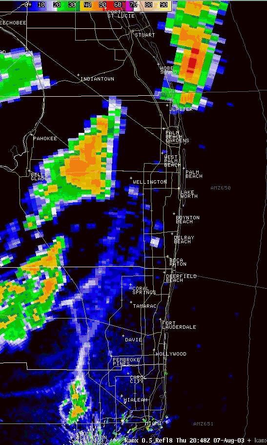
Radar reflectivity loop beginning at 4:48 PM EDT and ending at 5:35 PM EDT
GOES Visible Satellite Picture loop
showing sea breeze convergence line and outflow boundaries enhancing convection and helping to form the tornadoes
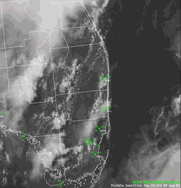
Visible satellite imagery showing outflow boundaries and sea breeze convergence line
top
Pictures
Jupiter Tornado (F0)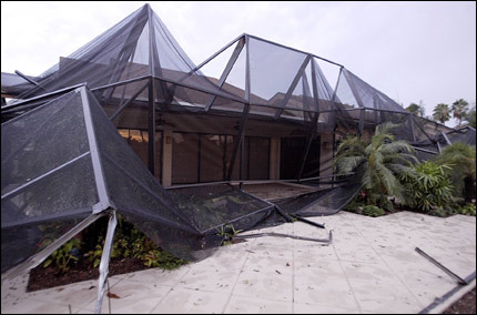
JUPITER - Tornado damage on E. River Park Drive in Jupiter. Trees were downed and screen patios were ripped apart on the street, just west of U.S. 1. Photo by Taylor Jones/The Palm Beach Post.
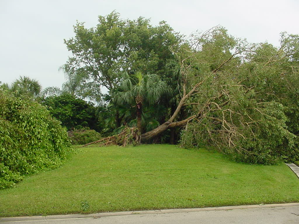
JUPITER - Tornado damage on N. River Park Drive in Jupiter.
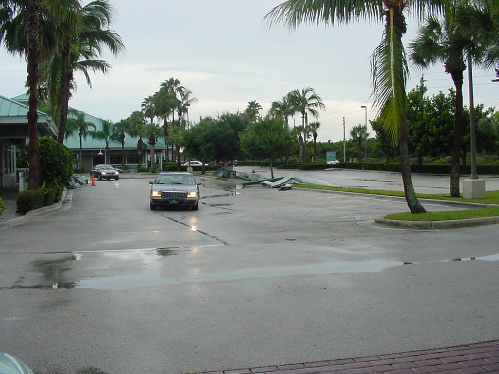
JUPITER - Tornado damage on U.S. 1 at a shopping center just south of Jupiter.
PALM BEACH GARDENS -
At A Garden Walk mobile home park, it was hit or miss whether a home sustained damage. More than 100 mobile homes were damaged, many overturned or flattened. Many residents were barred from returning to their homes overnight as deputies, paramedics and firefighters looked for injured among the wreckage. Photo by Shannon O'Brien/The Palm Beach Post.
RIVIERA BEACH -
The roof of a building (Pepsi plant) within the industrial park north of Blue Heron Boulevard is torn to pieces after a tornado swept through the area leaving a trail of debris in its wake. Staff photo by Shannon O'Brien courtesy Palm Beach Post.
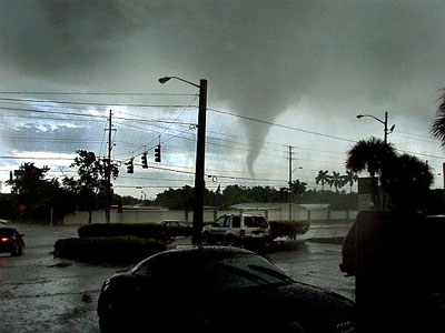
A tornado touches down in Palm Beach Gardens on Thursday evening. At least 30 homes were destroyed as the tornado raked across Palm Beach County.
(Photo/Jeff Hooper) courtesy South Florida Sun-Sentinel.

