Zone Changes
Effective Tuesday, April 2nd, 2019, five county public and fire weather forecast zones and one marine zone for NWS Weather Forecast Office (WFO) in Newport/Morehead City, NC (MHX) will be adjusted into different zones. Please read the overview sections below for a lot of details or if you prefer, jump to the images or table below.
Overview (land based zones)
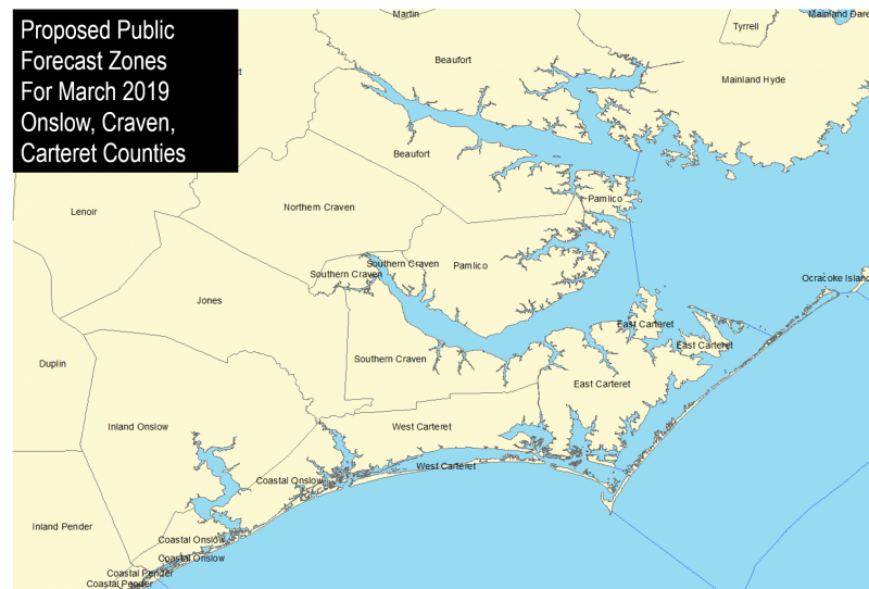
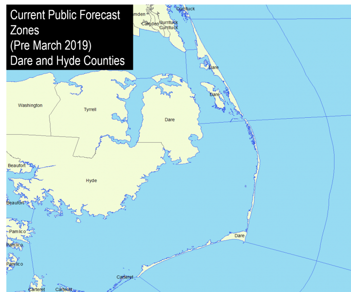
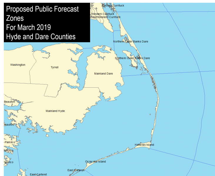
The NWS Weather Forecast Office (WFO) in Newport/Morehead City, NC (MHX) will add 5 new county segments within our land areas for the County Warning Area (CWA). The Outer Banks Hyde forecast zone will be changed to Ocracoke Island. The Outer Banks Dare forecast zone will be changed to Northern Outer Banks and Hatteras Island. The breakpoint will be at Oregon Inlet. Carteret County will be split from west to east along the north/south Intracoastal Waterway (ICW) which stretches from Beaufort Inlet north to the west side of Radio Island along the ICW to the Neuse River near Merrimon. Onslow County will be split between an inland zone and coastal zone, following Highway 17 into Sneads Ferry at the intersection of 210, across New River to the intersection of Highway 24 and Highway 172 in Hubert, then east to the intersection of Carteret and Jones counties. Craven county will be split into a Northern Craven and Southern Craven forecast zone. The breakpoints will be from Highway 17 entering Craven county from the southwest, to the intersection of Highway 17 and 70, to the intersection of Highway 55 and Highway 43, and finally east to the Pamlico County border at (35.155, -76.987 W). The towns of River Bend, Trent Woods, New Bern and Bridgeton being the northern extent of the Southern Craven forecast zone. For the marine zone change, the eastern end of the Albemarle Sound will end at a line stretching from mainland Dare county (35.954, -75.805) to Point Harbor (36.072, -75.794). The southern extent will be the northern boundary of the Pamlico Sound marine zone which ends at Oregon Inlet.
Overview (marine based zones)
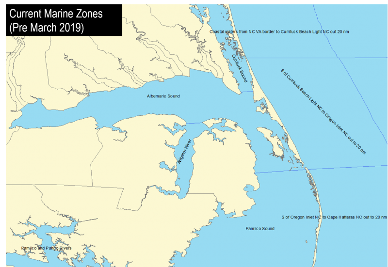
The NWS Weather Forecast Office (WFO) in Newport/Morehead City, NC (MHX) will add 1 new marine zone. For the marine zone change, the eastern end of the Albemarle Sound will end at a line stretching from mainland Dare county (35.954, -75.805) to Point Harbor (36.072, -75.794). The southern extent will be the northern boundary of the Pamlico Sound marine zone which ends at Oregon Inlet.
Zone Changes Old Versus New

.png/mareinafter(1)__800x552.png)
Further breaking up of the Outer Banks Dare forecast zone will allow for better communication of hazardous weather, especially for coastal and tropical events. The zone name changes will also better match the local geographic naming convention and also reduce confusion for non-residents. For Carteret County, this will allow for more precise designation of coastal hazards across Carteret county which often sees greater coastal flooding for the eastern half of the county. For Onslow County, this change will allow NWS products to better highlight coastal hazards for coastal communities rather than the entire county which stretches more than 25 miles inland for northwestern portions of the county. For Craven County, this zone breakup will better highlight coastal flooding issues along the Neuse and Trent Rivers. In addition, all of the forecast zone changes will allow for more refined forecast of hazardous weather across Eastern NC, both reducing areas inland away from coastal hazards, and be providing additional breakpoints for designating geographic extent of a given hazard event.
For the marine zone changes, this will allow for a more refined forecast for Kitty Hawk Bay, Croatan Sound and the Roanoke Sound from the much larger Albemarle Sound, which has a much more shallow bathymetry than the central and western Albemarle Sound.
These zone changes require partners and users to take appropriate action to receive the new zone products using the Universal Generic Code (UGC) zone code format (Z) listed in Table 1. Products affected by this change are listed in Table 2.
| Current Zone Name/ Current UGZ (Z) | New Public/Fire Zone Name / New UGC |
|
Outer Banks Hyde (NCZ104) |
Ocracoke Island (NCZ204) |
| Outer Banks Dare (NCZ103) |
Northern Outer Banks (NCZ203) Hatteras Island (NCZ205) |
| Craven (NCZ093) |
Northern Craven (NCZ193) Southern Craven (NCZ194) |
| Carteret (NCZ095) |
West Carteret (NCZ195) East Carteret (NCZ196) |
| Onslow (NCZ(098) |
Inland Onslow (NCZ198) Coastal Onslow (NCZ199) |
| Albemarle Sound (AMZ130) |
Albemarle Sound (AMZ230) Croatan and Roanoke Sounds (AMZ231) |
| Product Name | WMO Header | AWIPS ID |
|
Special Weather Statement Hurricane Local Statement Local Tropical Watch/Warning Extreme Wind Warning Zone Forecast Product Hazardous Weather Outlook Non-Precipitation Watch/Warning/Advisory Winter Weather Watch/Warning/Advisory Area Forecast Matrices Fire Weather Message Flood Watch/Warning/Advisory Hydrologic Outlook Fire Weather Watch/Red Flag Warning Public Information Statement Point Forecast Matrices Area Forecast Discussion Precipitation and Temperature Summary Daily River and Lake Summary Hydrologic Statement Hydrologic Statement Air Quality Alert Air Quality Forecast Surf Zone Forecast Coastal Hazard Message Special Marine Warnings Marine Weather Statements Marine Weather Message Coastal Waters Forecast Tide Report |
WWUS82 KMHX WTUS82 KMHX WTUS82 KMHX WTUS82 KMHX FPUS52 KMHX FLUS42 KMHX WWUS72 KMHX WWUS42 KMHX FOUS52 KMHX FNUS52 KMHX WGUS62 KMHX FGUS72 KMHX WWUS82 KMHX NOUS42 KMHX FOUS52 KMHX FXUS62 KMHX SXUS52 KMHX FGUS52 KMHX FGUS82 KMHX SRUS42 KMHX AEUS72 KMHX AEUS72 KMHX FZUS52 KMHX WHUS42 KMHX WHUS52 KMHX FZUS72 KMHX WHUS72 KMHX FZUS52 KMHX SOUS42 KMHX |
SPSMHX HLSMHX TCVMHX EWWMHX ZFPMHX HWOMHX NPWMHX WSWMHX AFMMHX FWFMHX FFAMHX ESFMHX RFWMHX PNSMHX PFMMHX AFDMHX HYDMHX RVDMHX RVSMHX RVAMHX AQAMHX AQIMHX SRFMHX CFWMHX SMWMHX MWSMHX MWMMHX CWFMHX TIDMHX |
If you are affected by these changes, take the appropriate action so your system(s) recognize the new zone (Z) Universal Geographic Codes (UGC) and the new zone alignments.
Updated public and fire zone map shapefile are available for download
at: https://www.weather.gov/gis/AWIPSShapefiles
The proposed changes to the MHX zone boundaries have been closely coordinated with local partners and customers to be ready for implementation on April 2nd, 2019.
|
Erik Heden Warning Coordination Meteorologist National Weather Service Newport/MoreheadCity 533 Roberts Road Newport, NC 28570 252-223-5737 erik.heden@noaa.gov |
John Koch Public Program Leader National Weather Service Eastern Region Headquarters 630 Johnson Avenue Bohemia, NY 11716 631-244-0104 john.koch@noaa.gov |


 Map View
 Weather Hazard Briefing (when applicable)
 Forecaster Discussion
 Marine
 Text Products
.png) Skywarn
Skywarn Submit Storm Reports
 Coastal Flood
.png) Surf Forecast/Rip Currents
Surf Forecast/Rip Currents