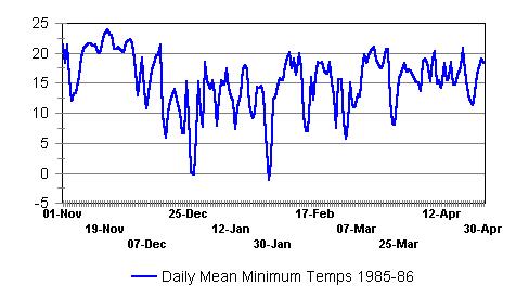
Florida Dry Season Temperature and El Nino-Southern Oscillation (ENSO) Bart Hagemeyer It is generally believed that in Florida average dry season temperatures are cooler during El Nino periods and warmer during La Nina periods, but that the risk of major freezes is generally greater during neutral and weak La Nina periods than El Nino periods. The reasoning is that during El Nino conditions the mean storm tracks are further south increasing storminess over the Gulf of America and bringing more cloudiness and rainfall to Florida which over time decreases the mean temperature in the Florida region. At the same time warmer than normal temperatures are found over western Canada and the US Northern Plains which are the source regions for arctic air outbreaks that can affect Florida. So there are warmer temperatures up north and the southern storm track means there is less chance passing cyclones will pull down cold northern air deep into the southeast. Conversely during La Nina years with less storminess in Florida, attendant clouds and rainfall, and more sunshine, mean temperatures are warmer than normal over the Florida Region. Temperatures are more likely to be below normal over western Canada and the Northern Plains providing a source region for arctic outbreaks. The northern storm track also means there is a greater chance that passing cyclones can pull down cold air behind them into the southeast. However, the picture is not nearly as simple as described above. Indeed, when one tries to correlate the state of ENSO with Florida dry season temperature variables one finds much less skill compared to rainfall, storminess, and severe storms. For the purposes of this research project, we looked at average mean temperature and average dry season minimum temperature over the Florida grid, and the number of events of temperatures falling below 0 (defined as a major freeze) and 5 degrees centigrade (a measure of seasonal "cold spells") averaged over interior central Florida per dry season. For example, to calculate the "cold events" for the 1985-86 dry season, a plot of daily average minimum temperature over interior central Florida from 1 November through 30 April was examined for the number of time the temperature reached minimums below zero and five degrees (C). In this case 2 events were below zero degrees (major freeze) and also five degrees (cold spell). The zero and five degree events happened to be coincident in this season, typically there are more five degree events than zero events. It should be understood that this is a very conservative and harsh measure for freezes, these temperatures are not from a single reporting station for a single day, but are averaged over an area bounded by 28 to 29 north latitude and 81 to 82.5 west longitude as proxy for interior central Florida. It should be noted that major or severe freezes in central Florida defined in this manner are rare, averaging only about 1/4 of a severe freeze per year since 1958 and generally average only a few days in duration.
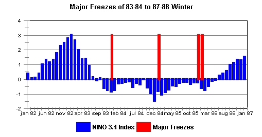
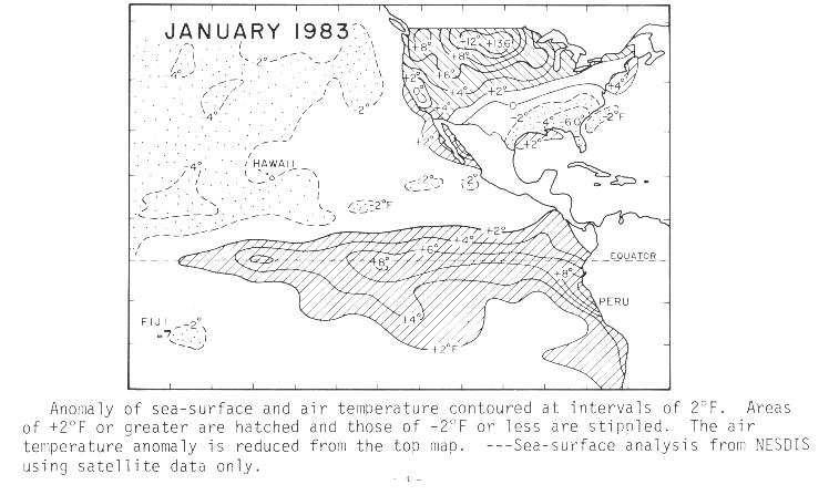
When one correlates this "cold event" data set with ENSO state one finds a very weak relationship. It is clear ENSO is not the only factor influencing Florida dry season temperature extremes. Perhaps the best example is the period from the 83-84 to the 87 -88 dry seasons in which a strong El Nino transitioned to La Nina conditions and each winter La Nina strengthened and major freezes occurred - tending to support a relationship with La Nina and major Florida freezes.
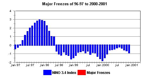
However, the ENSO conditions from the dry season of 1996-97 through 2000-2001 were nearly a carbon copy of 1983-84 to 1987-88 conditions in which a strong El Nino gave way to three dry consecutive seasons of strong La Nina conditions, but no major freezes occurred. A freeze occurred in December 2000 in the third year of the strong La Nina, but it did not qualify statistically as a major freeze and no widespread damage was reported.
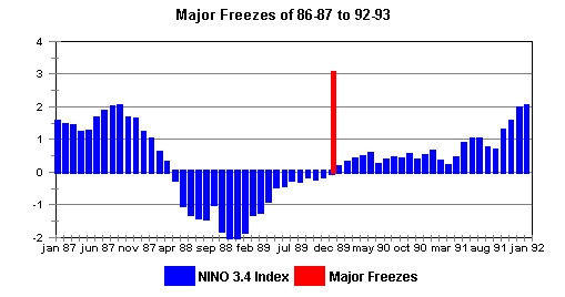
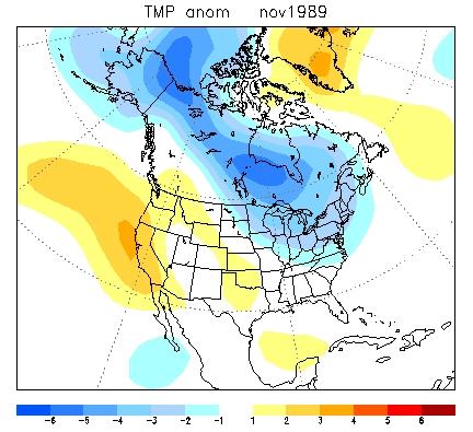
Another example is the observation that there was no major freeze in the 88-89 dry season with a very strong La Nina, but a major freeze did occur the next season (89-90) when ENSO was neutral and slowly transitioning to EL Nino conditions.
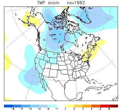
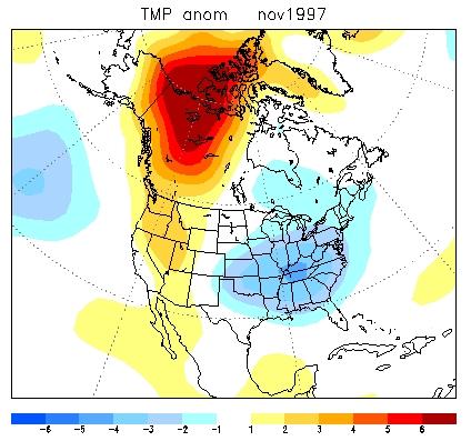
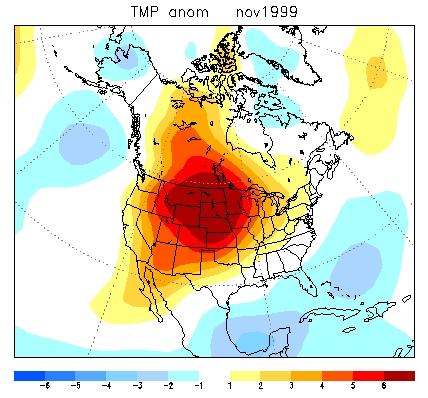
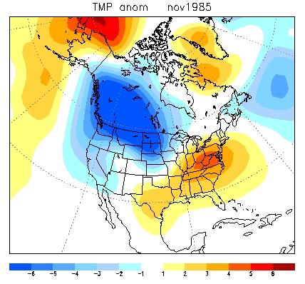
A Complex Relationship for Temperature What we do know is that most major freezes since 1958 occurred when ENSO was technically in neutral or weak La Nina conditions, however, this criteria has a high false alarm rate. The existence of cold air to the north and a favorable storm track to the north of Florida does not guaranty that a freeze will occur, but it increases the likelihood. Nevertheless, one can say the risk of severe freeze is greater in neutral and La Nina years simply because there will probably be more favorable synoptic opportunities than during El Nino years. There are at least two complex issues, one is having cold air over the source regions to the north of Florida and the other is having a storm track that is favorable for pulling that cold air southward in Florida. Clearly seasons with cold air to the north are more favorable - the issue is getting the air as far south as Florida behind a strong arctic cold front without considerable modification. Other factors such as extent of snow cover over the north and central plains can play a part in allowing colder air to reach further south. It is becoming more clear that the state of ENSO largely controls the storm tracks over Florida, but that other large-scale phenomena such as the North Atlantic Oscillation (NAO) and Arctic Oscillation (AO) play a significant role in the temperature of the source region and whether storm tracks will tend to pull cold air well southward to Florida. The NAO and AO are not as well-understood as ENSO and much less predictable and more highly variable within a season than ENSO. In general, the positive phase of NAO is characterized by lower than normal pressure over the North Atlantic and higher than normal pressure over the equatorial Atlantic. This leads to milder weather to the north of Florida. The negative phase of the NAO is characterized by higher than normal pressure over the north Atlantic and lower than normal pressure over the equatorial Atlantic. This causes stormier weather than normal north of Florida and thus a much greater chance of bringing polar air southward. This is clearly an example of a"tangled system" discussed in the section on seasonal forecasting and predictability and the interplay between ENSO and a strong phase of the NAO would be difficult to predict. What we can reasonably assume is that during strong EL Nino's the predominant southern storm track would greatly limit the chances of pulling cold air southward into Florida, regardless of weather it was unusually warm or cold in this source region. In addition, the increased storminess over Florida would generally bring below normal "average" seasonal temperatures due to increased cloud cover and precipitation. During strong La Ninas the predominant northern storm track would be more likely to pull cold air down into Florida, but above or below normal temperatures in the source region probably depend on other factors. The general lack of storminess over Florida during strong La Ninas would mean more sunshine and less rain, and above normal "average" seasonal temperatures, but clearly a greater chance of cold spells. Neutral or near neutral ENSO conditions may well allow the NAO to dominate the weather patterns, but again this is highly speculative. One thing is for sure with regard to Florida freezes, the key is to keep tabs on temperatures in the source regions to the north and watch the storm tracks. Below are a few examples of the diversity of source region conditions in various ENSO phases, making long range freeze or cold spell predictions based solely on the state of ENSO highly speculative. Strong EL Nino - Colder than normal in source region Strong EL Nino - Much Warmer than normal in source region. Strong La Nina - Much Warmer than normal in source region Moderate La Nina - Much Colder than normal in source region Neutral ENSO - Cooler than normal in source region References: Extreme Rainfall and Temperature Anomalies - Winter '97 - Summer '98 Attaway, J. A., 1997: A History of Florida Citrus Freezes. Florida Science Source, INC. 368 pages. ISBN 0-944961-03-7. Hagemeyer, B.C., 2006: ENSO, PNA and NAO Scenarios for extreme storminess, rainfall and temperature variability during the Florida dry season, Preprints, 18th Conference on Climate Variability and Change, Amer. Meteor. Soc., Atlanta, GA, CD -ROM P2.4. Hagemeyer, B.C., 2007: The relationship between ENSO, PNA, and AO/NAO and extreme storminess, rainfall, and temperature variability during the Florida dry season: thoughts on predictability and attribution, Preprints, 19th Conference on Climate Variability and Change, Amer. Meteor. Soc., San Antonio, TX, CD-ROM JP2.16. Hagemeyer, B. C., 2007: Attribution of extreme variability of temperature and rainfall in the Florida dry season. NOAA 32nd Annual Climate Diagnostics and Prediction Workshop. Tallahassee, FL (10/07). Hagemeyer, B.C., 2008: Attribution of extreme variability of temperature to major teleconnections and development of probabilistic aides for decision making using logistic regression: A case study of a Florida frost hollow. Preprint, 20th Conference on Climate Variability and Change, Amer. Meteor. Soc., New Orleans, LA, CD-ROM P2.2.
Florida region seasonal forecast development: Bart Hagemeyer. Content Last Updated 8/10/10. |
|

