
Late October Coastal Tornado Outbreak
October 29th and 30th, 2022
Summary of all Local Storm Reports (LSRs) on October 29th and 30th, as well as all the LSRs across the region for this event.
Storm survey teams preliminarily concluded that there was 4 EF-1 tornadoes and 8 EF-0 tornadoes that occurred in our forecast area - 5 tornadoes in Mobile County, AL, 6 tornadoes in Baldwin County, AL, and 1 tornado in Okaloosa County, FL.
The data provided on this page are considered preliminary as we continue to analyze all available data. We will add more information to this page and social media as it becomes available. We thank you in advance for your patience.
Dawes Tornado (Mobile County, AL)
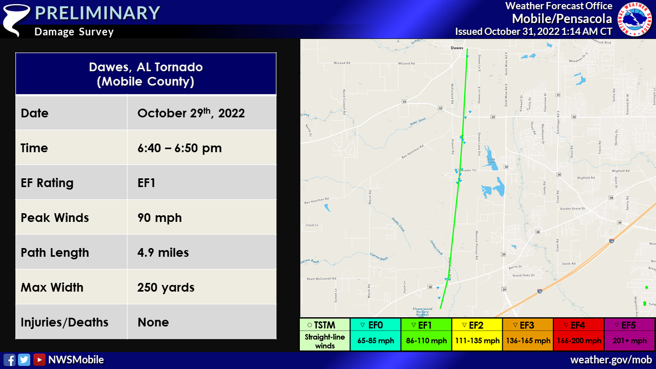
Public Information Statement
National Weather Service Mobile AL
102 AM CDT Mon Oct 31 2022

...NWS Damage Survey for 10/29/22 Tornado Event - Update #1...

.Update...Surveys continue across the area with two confirmed
tornadoes in west Mobile. Additional information on the tornado near
Brookley Field will be available later this week once more data is
available for our teams.

..Dawes Tornado...

Rating:                 EF1
Estimated Peak Wind:    90 mph
Path Length /statute/:  4.9 miles
Path Width /maximum/:   250 yards
Fatalities:             0
Injuries:               0

Start Date:             10/29/2022
Start Time:             06:40 PM CDT
Start Location:         2 NNW Saint Elmo / Mobile County / AL
Start Lat/Lon:          30.537 / -88.2623

End Date:               10/29/2022
End Time:               06:50 PM CDT
End Location:           Dawes / Mobile County / AL
End Lat/Lon:            30.6075 / -88.2537

Survey Summary:
Tornado likely began in a field to the southwest the Pecan
Terrace subdivision and moved north-northeast as it crossed Old
Pascagoula Rd. The damage was predominantly confined to trees and
fences as the tornado moved toward Dep Busby Rd. The tornado then
moved across open fields and cotton fields for about a mile and a
half. The tornado moved across the Labrador Trail subdivision
with significant damage to fences with shingle and soffit/fascia
damage noted on many homes in the neighborhood. Several sheds in
the neighborhood were also damaged. The tornado then crossed
another large field before moving across Dawes Creek Drive and
Dawes Oak Drive. A home along Dawes Oak Drive had two south-
facing windows pushed in and broken with roof damage, which
prompted the low-end EF-1 rating for this point. The tornado
continued off to the north-northeast as it crossed Three Notch
Road. The tornado likely lifted near Dawes Lane N given the lack
of damage to the north of this road.

&&

EF Scale: The Enhanced Fujita Scale classifies tornadoes into the
following categories:

EF0...Weak......65 to 85 mph
EF1...Weak......86 to 110 mph
EF2...Strong....111 to 135 mph
EF3...Strong....136 to 165 mph
EF4...Violent...166 to 200 mph
EF5...Violent...>200 mph

NOTE:
The information in this statement is preliminary and subject to
change pending final review of the events and publication in NWS
Storm Data.
Orchard Tornado (Mobile County, AL)
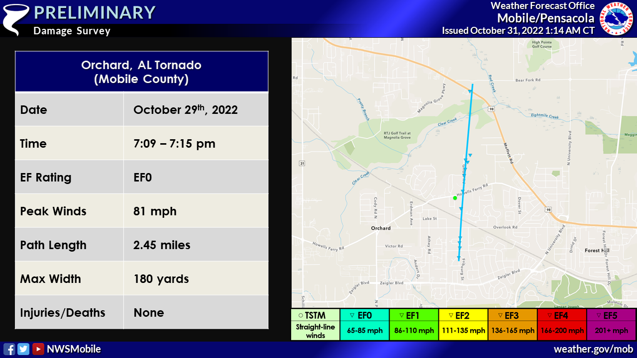
Public Information Statement
National Weather Service Mobile AL
102 AM CDT Mon Oct 31 2022

...NWS Damage Survey for 10/29/22 Tornado Event - Update #1...

.Update...Surveys continue across the area with two confirmed
tornadoes in west Mobile. Additional information on the tornado near
Brookley Field will be available later this week once more data is
available for our teams.

..Orchard Tornado...

Rating:                 EF0
Estimated Peak Wind:    81 mph
Path Length /statute/:  2.5 miles
Path Width /maximum/:   180 yards
Fatalities:             0
Injuries:               0

Start Date:             10/29/2022
Start Time:             07:09 PM CDT
Start Location:         1 ESE Orchard / Mobile County / AL
Start Lat/Lon:          30.713 / -88.1879

End Date:               10/29/2022
End Time:               07:15 PM CDT
End Location:           2 NNE Orchard / Mobile County / AL
End Lat/Lon:            30.7483 / -88.1846

Survey Summary:
Tornado began along Lucerne Drive and moved north-northeast as it
crossed Overlook Road. The damage along Lucerne Drive was
predominantly confined to trees and fences as the tornado moved
toward Donham Drive. The tornado then crossed Howells Ferry Road
and moved along Grider Road. The tornado continued to the north-
northeast with more damage to sheds and homes along Grider Road.
One home near Rose Hill Lane had some uplift to the roof with
more tree damage nearby. The tornado moved over a heavily wooded
area before likely lifting around Moffett Road. The tornado may
have continued off to the north-northeast, but that wooded area
is completely inaccessible.


&&

EF Scale: The Enhanced Fujita Scale classifies tornadoes into the
following categories:

EF0...Weak......65 to 85 mph
EF1...Weak......86 to 110 mph
EF2...Strong....111 to 135 mph
EF3...Strong....136 to 165 mph
EF4...Violent...166 to 200 mph
EF5...Violent...>200 mph

NOTE:
The information in this statement is preliminary and subject to
change pending final review of the events and publication in NWS
Storm Data.
Theodore Tornado (Mobile County, AL)
 Public Information Statement
National Weather Service Mobile AL
1011 AM CDT Fri Nov 4 2022
...NWS Damage Survey for 10/29/22 Tornado Event Update #3...
Overview...After review of the available radar and survey data
another tornado has been confirmed from the October 29th, 2022
tornado outbreak in the Theodore, AL area.
..Theodore Tornado...
Rating: EF0
Estimated Peak Wind: 70 mph
Path Length /statute/: 1.84 miles
Path Width /maximum/: 20.0 yards
Fatalities: 0
Injuries: 0
Start Date: 10/29/2022
Start Time: 05:03 PM CDT
Start Location: 2 WNW Laurendine / Mobile County / AL
Start Lat/Lon: 30.516 / -88.1968
End Date: 10/29/2022
End Time: 05:08 PM CDT
End Location: 1 WSW Theodore / Mobile County / AL
End Lat/Lon: 30.5427 / -88.1978
Survey Summary:
An EF-0 tornado likely began just to the south of Government
Boulevard near Theodore tracking north across the area. The
beginning point of the tornado is estimated by a radar confirmed
debris signature that started in a heavily wooded area to the
south of Government Boulevard. The tornado crossed Government
Blvd and tracked up through Tung Avenue West where some minor
tree damage occurred with numerous limbs knocked down and a fence
was blown over. The tornado continued across Oakane Drive where
minor shingle damage occurred to homes. At this point the tornado
likely lifted with no further damage reports to the north.
&&
EF Scale: The Enhanced Fujita Scale classifies tornadoes into the
following categories:
EF0...Weak......65 to 85 mph
EF1...Weak......86 to 110 mph
EF2...Strong....111 to 135 mph
EF3...Strong....136 to 165 mph
EF4...Violent...166 to 200 mph
EF5...Violent...>200 mph
NOTE:
The information in this statement is preliminary and subject to
change pending final review of the event and publication in NWS
Storm Data.
Public Information Statement
National Weather Service Mobile AL
1011 AM CDT Fri Nov 4 2022

...NWS Damage Survey for 10/29/22 Tornado Event Update #3...

Overview...After review of the available radar and survey data
another tornado has been confirmed from the October 29th, 2022
tornado outbreak in the Theodore, AL area.

..Theodore Tornado...

Rating:                 EF0
Estimated Peak Wind:    70 mph
Path Length /statute/:  1.84 miles
Path Width /maximum/:   20.0 yards
Fatalities:             0
Injuries:               0

Start Date:             10/29/2022
Start Time:             05:03 PM CDT
Start Location:         2 WNW Laurendine / Mobile County / AL
Start Lat/Lon:          30.516 / -88.1968

End Date:               10/29/2022
End Time:               05:08 PM CDT
End Location:           1 WSW Theodore / Mobile County / AL
End Lat/Lon:            30.5427 / -88.1978

Survey Summary:
An EF-0 tornado likely began just to the south of Government
Boulevard near Theodore tracking north across the area. The
beginning point of the tornado is estimated by a radar confirmed
debris signature that started in a heavily wooded area to the
south of Government Boulevard. The tornado crossed Government
Blvd and tracked up through Tung Avenue West where some minor
tree damage occurred with numerous limbs knocked down and a fence
was blown over. The tornado continued across Oakane Drive where
minor shingle damage occurred to homes. At this point the tornado
likely lifted with no further damage reports to the north.


&&

EF Scale: The Enhanced Fujita Scale classifies tornadoes into the
following categories:

EF0...Weak......65 to 85 mph
EF1...Weak......86 to 110 mph
EF2...Strong....111 to 135 mph
EF3...Strong....136 to 165 mph
EF4...Violent...166 to 200 mph
EF5...Violent...>200 mph

NOTE:
The information in this statement is preliminary and subject to
change pending final review of the event and publication in NWS
Storm Data.
Pine Grove Tornado (Mobile County, AL)
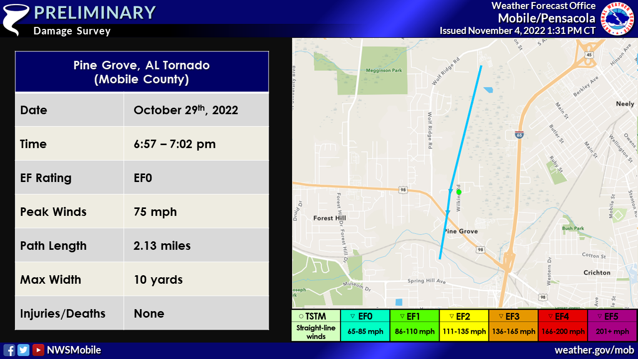 Public Information Statement
National Weather Service Mobile AL
119 PM CDT Fri Nov 4 2022
...NWS Damage Survey for 10/29/22 Tornado Event - Update #4...
.Update... An additional storm survey was conducted today and
another EF-0 tornado was found to have occurred in the Pine Grove,
AL area during the October 29th, 2022 tornado outbreak.
..Pine Grove Tornado...
Rating: EF0
Estimated Peak Wind: 75 mph
Path Length /statute/: 2.13 miles
Path Width /maximum/: 10.0 yards
Fatalities: 0
Injuries: 0
Start Date: 10/29/2022
Start Time: 06:57 PM CDT
Start Location: 1 ESE Forest Hill / Mobile County / AL
Start Lat/Lon: 30.7087 / -88.1346
End Date: 10/29/2022
End Time: 07:02 PM CDT
End Location: 2 S Eight Mile / Mobile County / AL
End Lat/Lon: 30.739 / -88.1271
Survey Summary:
A weak EF-0 tornado with peak winds of 75mph likely began in Pine
Grove along Threemile Creek and quickly moved north across
Moffett Road where a tornado debris signature became apparent on
radar. This tornado continued along Pine Grove Avenue where a
couple of older/dead trees were knocked down and healthier large
tree limbs were knocked down at the intersection of Pine Grove
Avenue and Pringle Drive. Due to limited road access north of
this point, the rest of the tornadoes path is approximated based
on radar tornado debris signature and rotational velocity. It is
likely the tornado ended just to the southeast of Laidlaw Lane
prior to reaching Wolf Ridge Road.
&&
EF Scale: The Enhanced Fujita Scale classifies tornadoes into the
following categories:
EF0...Weak......65 to 85 mph
EF1...Weak......86 to 110 mph
EF2...Strong....111 to 135 mph
EF3...Strong....136 to 165 mph
EF4...Violent...166 to 200 mph
EF5...Violent...>200 mph
NOTE:
The information in this statement is preliminary and subject to
change pending final review of the event and publication in NWS
Storm Data.
Public Information Statement
National Weather Service Mobile AL
119 PM CDT Fri Nov 4 2022

...NWS Damage Survey for 10/29/22 Tornado Event - Update #4...

.Update... An additional storm survey was conducted today and
another EF-0 tornado was found to have occurred in the Pine Grove,
AL area during the October 29th, 2022 tornado outbreak.

..Pine Grove Tornado...

Rating:                 EF0
Estimated Peak Wind:    75 mph
Path Length /statute/:  2.13 miles
Path Width /maximum/:   10.0 yards
Fatalities:             0
Injuries:               0

Start Date:             10/29/2022
Start Time:             06:57 PM CDT
Start Location:         1 ESE Forest Hill / Mobile County / AL
Start Lat/Lon:          30.7087 / -88.1346

End Date:               10/29/2022
End Time:               07:02 PM CDT
End Location:           2 S Eight Mile / Mobile County / AL
End Lat/Lon:            30.739 / -88.1271

Survey Summary:
A weak EF-0 tornado with peak winds of 75mph likely began in Pine
Grove along Threemile Creek and quickly moved north across
Moffett Road where a tornado debris signature became apparent on
radar. This tornado continued along Pine Grove Avenue where a
couple of older/dead trees were knocked down and healthier large
tree limbs were knocked down at the intersection of Pine Grove
Avenue and Pringle Drive. Due to limited road access north of
this point, the rest of the tornadoes path is approximated based
on radar tornado debris signature and rotational velocity. It is
likely the tornado ended just to the southeast of Laidlaw Lane
prior to reaching Wolf Ridge Road.


&&

EF Scale: The Enhanced Fujita Scale classifies tornadoes into the
following categories:

EF0...Weak......65 to 85 mph
EF1...Weak......86 to 110 mph
EF2...Strong....111 to 135 mph
EF3...Strong....136 to 165 mph
EF4...Violent...166 to 200 mph
EF5...Violent...>200 mph

NOTE:
The information in this statement is preliminary and subject to
change pending final review of the event and publication in NWS
Storm Data.
Downtown Mobile Airport Tornado (Mobile County, AL)
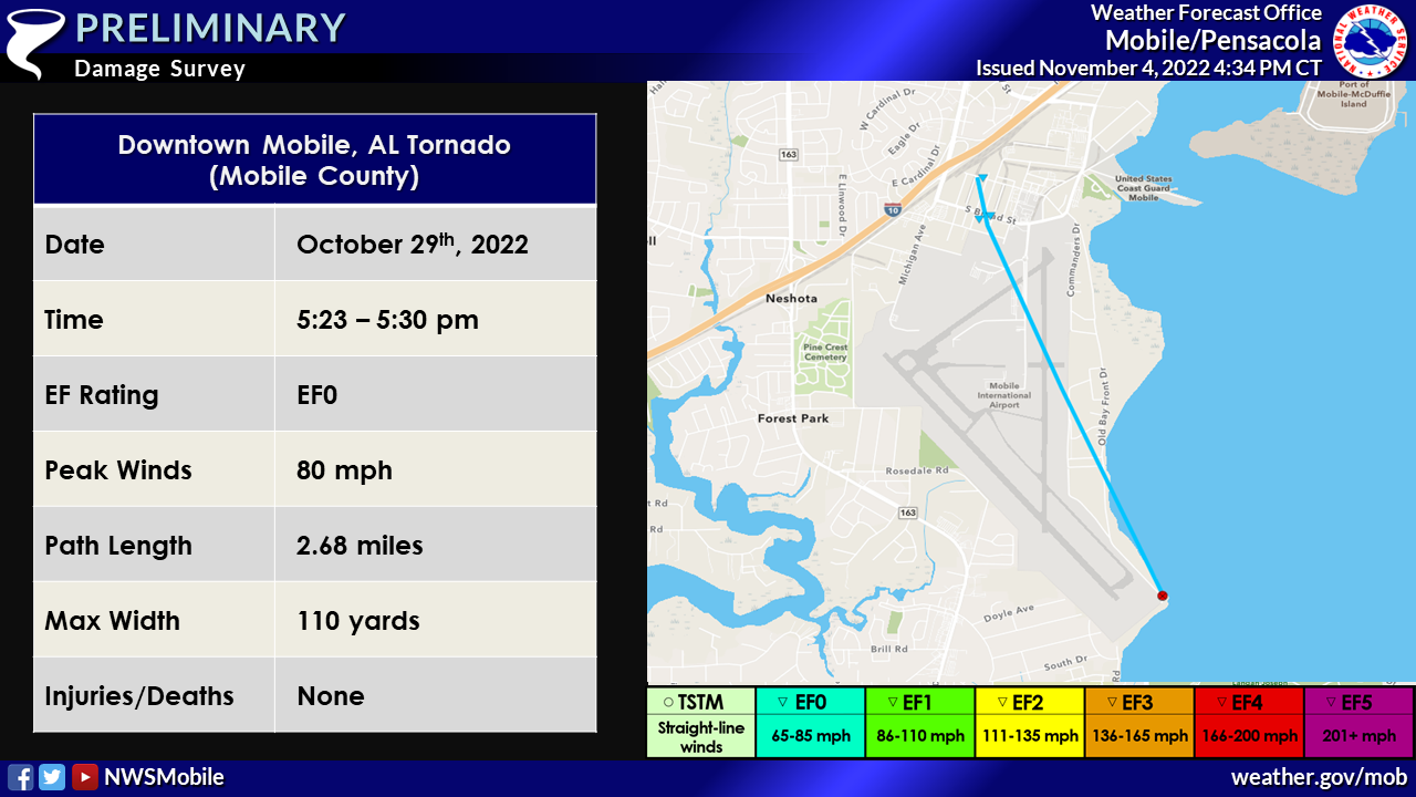 Public Information Statement
National Weather Service Mobile AL
425 PM CDT Fri Nov 4 2022
...NWS Damage Survey for 10/29/22 through 10/30/22 Tornado
Event...
Public Information Statement
National Weather Service Mobile AL
425 PM CDT Fri Nov 4 2022

...NWS Damage Survey for 10/29/22 through 10/30/22 Tornado
Event...
..Mobile Downtown Airport Tornado...

Rating:                 EF0
Estimated Peak Wind:    80 mph
Path Length /statute/:  2.6768 miles
Path Width /maximum/:   110.0 yards
Fatalities:             0
Injuries:               0

Start Date:             10/29/2022
Start Time:             05:23 PM CDT
Start Location:         3 SE Neshota / Mobile County / AL
Start Lat/Lon:          30.613 / -88.0551

End Date:               10/29/2022
End Time:               05:30 PM CDT
End Location:           1 NE Neshota / Mobile County / AL
End Lat/Lon:            30.6488 / -88.0721

Survey Summary:
An EF-0 tornado came onshore near the southern end of Mobile
Downtown Airport. The start point of this is based on visual
confirmation of the tornado via pictures and video. The tornado
crossed parts of the airport, with no notable damage being
reported. As the tornado tracked northwest, it moved across South
Broad Street where it removed branches from trees and damaged
some fencing. The final observable damage point was on Avenue C
where metal roofing was removed from a building, with the metal
canopy/overhang collapsed at the end of the building. The tornado
may have continued slightly north-northwest of this point, but the
area was inaccessible due to limited road access.
&&

EF Scale: The Enhanced Fujita Scale classifies tornadoes into the
following categories:

EF0...Weak......65 to 85 mph
EF1...Weak......86 to 110 mph
EF2...Strong....111 to 135 mph
EF3...Strong....136 to 165 mph
EF4...Violent...166 to 200 mph
EF5...Violent...>200 mph

NOTE:
The information in this statement is preliminary and subject to
change pending final review of the events and publication in NWS
Storm Data.
Magnolia Springs Tornado (Baldwin County, AL)
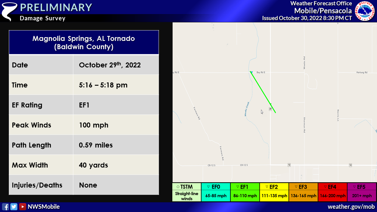
Public Information Statement
National Weather Service Mobile AL
815 PM CDT Sun Oct 30 2022

...NWS Damage Survey for 10/29/22 Baldwin County Tornado Event...

.Magnolia Springs Tornado...

Rating:                 EF1
Estimated Peak Wind:    100 mph
Path Length /statute/:  0.5937 miles
Path Width /maximum/:   40.0 yards
Fatalities:             0
Injuries:               0

Start Date:             10/29/2022
Start Time:             05:16 PM CDT
Start Location:         2 SSE Magnolia Springs / Baldwin County / AL
Start Lat/Lon:          30.3638 / -87.7665

End Date:               10/29/2022
End Time:               05:18 PM CDT
End Location:           2 S Magnolia Springs / Baldwin County / AL
End Lat/Lon:            30.3703 / -87.773

Survey Summary:
Tornado likely began in a field to the southeast of county road
49 and moved northeast across county road 49 south of Bay Rd E.
Several wood power poles were snapped at this location; however,
age of power poles suggested lower bound and lack of other damage
indicators. Weak tree debris was noted along Bay Rd E where
social media video suggests the tornado lifted as it crossed Bay
Rd E.

&&

EF Scale: The Enhanced Fujita Scale classifies tornadoes into the
following categories:

EF0...Weak......65 to 85 mph
EF1...Weak......86 to 110 mph
EF2...Strong....111 to 135 mph
EF3...Strong....136 to 165 mph
EF4...Violent...166 to 200 mph
EF5...Violent...>200 mph

NOTE:
The information in this statement is preliminary and subject to
change pending final review of the events and publication in NWS
Storm Data.
Bon Secour Tornado (Baldwin County, AL)
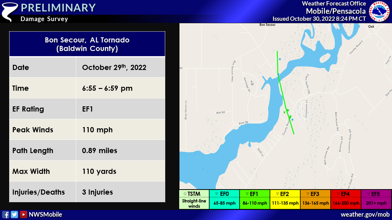
Public Information Statement
National Weather Service Mobile AL
815 PM CDT Sun Oct 30 2022

...NWS Damage Survey for 10/29/22 Baldwin County Tornado Event...

.Bon Secour Tornado...

Rating:                 EF1
Estimated Peak Wind:    110 mph
Path Length /statute/:  0.8888 miles
Path Width /maximum/:   110.0 yards
Fatalities:             0
Injuries:               3

Start Date:             10/29/2022
Start Time:             06:55 PM CDT
Start Location:         1 SSE Bon Secour / Baldwin County / AL
Start Lat/Lon:          30.302 / -87.7226

End Date:               10/29/2022
End Time:               06:59 PM CDT
End Location:           Bon Secour / Baldwin County / AL
End Lat/Lon:            30.3144 / -87.7262

Survey Summary:
Tornado likely began in a heavily forested area southeast of
County Road 6. The tornado then quickly tracked northeast where
the first damage was reported. A barn lost most of its tin
roofing and several large hard and softwood branches were
snapped. The tornado intensified as it crossed County Road
6 where a couple large hardwoods and softwoods were uprooted. Peak
intensity occurred just north of County Road 6 where a
manufactured home was rolled and completely destroyed.
3 individuals were inside the home and were transported to the
hospital with minor injuries. A pontoon boat on a trailer was
dragged about 30 yards and deposited on a stump causing the boat
to shift on the trailer. A few hard and softwood snaps were also
located at the area. The tornado then continued on northeast
causing minor tree damage. The tornado then crossed the Bon
Secour river causing minor damage to a construction site and
minor tree damage. The Tornado likely lifted shortly after with
sporadic wind damage noted along Bon Secour highway.

&&

EF Scale: The Enhanced Fujita Scale classifies tornadoes into the
following categories:

EF0...Weak......65 to 85 mph
EF1...Weak......86 to 110 mph
EF2...Strong....111 to 135 mph
EF3...Strong....136 to 165 mph
EF4...Violent...166 to 200 mph
EF5...Violent...>200 mph

NOTE:
The information in this statement is preliminary and subject to
change pending final review of the events and publication in NWS
Storm Data.
Skunk Bayou Tornado (Baldwin County, AL)
Public Information Statement
National Weather Service Mobile AL
358 PM CDT Wed Nov 2 2022

...NWS Damage Survey for 10/29/22 Tornado Event Update #2...
.Skunk Bayou Tornado...

Rating:                 EF0
Estimated Peak Wind:    85 mph
Path Length /statute/:  0.5068 miles
Path Width /maximum/:   20.0 yards
Fatalities:             0
Injuries:               0

Start Date:             10/29/2022
Start Time:             05:10 PM CDT
Start Location:         2 W Bon Secour / Baldwin County / AL
Start Lat/Lon:          30.3159 / -87.7587

End Date:               10/29/2022
End Time:               05:12 PM CDT
End Location:           2 WNW Bon Secour / Baldwin County / AL
End Lat/Lon:            30.3232 / -87.7585

Survey Summary:
The tornado likely started south of county road 49 in Skunk
Bayou. The tornado moved north resulting in uprooted softwood
pines, one snapped pine along county road 49. A chicken coop was
flipped and a barn destroyed just west of Carver Rd. Sporadic
large limbs were noted on carver road and a travel trailer had
its windows broken by debris. The tornado likely lifted just
north of county road 49.
&&

EF Scale: The Enhanced Fujita Scale classifies tornadoes into the
following categories:

EF0...Weak......65 to 85 mph
EF1...Weak......86 to 110 mph
EF2...Strong....111 to 135 mph
EF3...Strong....136 to 165 mph
EF4...Violent...166 to 200 mph
EF5...Violent...>200 mph

NOTE:
The information in this statement is preliminary and subject to
change pending final review of the events and publication in NWS
Storm Data.
Point Clear Tornado (Baldwin County, AL)
![]()
Public Information Statement
National Weather Service Mobile AL
815 PM CDT Sun Oct 30 2022


...NWS Damage Survey for 10/29/22 Baldwin County Tornado Event...

..Point Clear Tornado...

Rating:                 EF0
Estimated Peak Wind:    85 mph
Path Length /statute/:  0.02 miles
Path Width /maximum/:   20.0 yards
Fatalities:             0
Injuries:               0

Start Date:             10/29/2022
Start Time:             08:51 PM CDT
Start Location:         2 SSE Point Clear / Baldwin County / AL
Start Lat/Lon:          30.4426 / -87.9109

End Date:               10/29/2022
End Time:               08:52 PM CDT
End Location:           2 SSE Point Clear / Baldwin County / AL
End Lat/Lon:            30.4429 / -87.9109

Survey Summary:
A very brief EF0 tornado with peak winds of around 85mph touched
down off of Scenic Highway 98 by James Lowe Lane in southwestern
Baldwin County. The tornado uprooted a hardwood tree, shifted a
wooden carport off its holding blocks, and shifted a loaded
trailer approximately 20 feet from its resting position at this
location. Damage was confirmed to be from a tornado thanks to
video by local residents. Sporadic wind damage was observed in
the surrounding area, and it is possible the tornado began before
this point and continued further north, but limited access to
roads made it difficult to assess.

&&

EF Scale: The Enhanced Fujita Scale classifies tornadoes into the
following categories:

EF0...Weak......65 to 85 mph
EF1...Weak......86 to 110 mph
EF2...Strong....111 to 135 mph
EF3...Strong....136 to 165 mph
EF4...Violent...166 to 200 mph
EF5...Violent...>200 mph

NOTE:
The information in this statement is preliminary and subject to
change pending final review of the events and publication in NWS
Storm Data.
Spanish Fort Tornado (Baldwin County, AL)
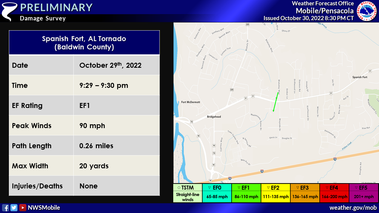
Public Information Statement
National Weather Service Mobile AL
815 PM CDT Sun Oct 30 2022


...NWS Damage Survey for 10/29/22 Baldwin County Tornado Event...

..Spanish Fort Tornado...

Rating:                 EF1
Estimated Peak Wind:    90 mph
Path Length /statute/:  0.2577 miles
Path Width /maximum/:   20.0 yards
Fatalities:             0
Injuries:               0

Start Date:             10/29/2022
Start Time:             09:29 PM CDT
Start Location:         Spanish Fort / Baldwin County / AL
Start Lat/Lon:          30.6688 / -87.8956

End Date:               10/29/2022
End Time:               09:30 PM CDT
End Location:           Spanish Fort / Baldwin County / AL
End Lat/Lon:            30.6723 / -87.8944

Survey Summary:
An EF1 tornado began in the Spanish Fort area of Baldwin County
with peak winds of 90mph. This tornado likely began near or just
southwest of Waites Lane where it snapped and uprooted a couple
hardwood trees. The tornado was intermittently touching down,
lifting briefly after this first point, before once again
touching down to the northeast after crossing Spanish Fort Blvd
moving onto the City Hall property. Here it snapped a couple of
pines and uprooted a hardwood tree. The tornado likely went
further northeast, but damage became rather sporadic.


&&

EF Scale: The Enhanced Fujita Scale classifies tornadoes into the
following categories:

EF0...Weak......65 to 85 mph
EF1...Weak......86 to 110 mph
EF2...Strong....111 to 135 mph
EF3...Strong....136 to 165 mph
EF4...Violent...166 to 200 mph
EF5...Violent...>200 mph

NOTE:
The information in this statement is preliminary and subject to
change pending final review of the events and publication in NWS
Storm Data.
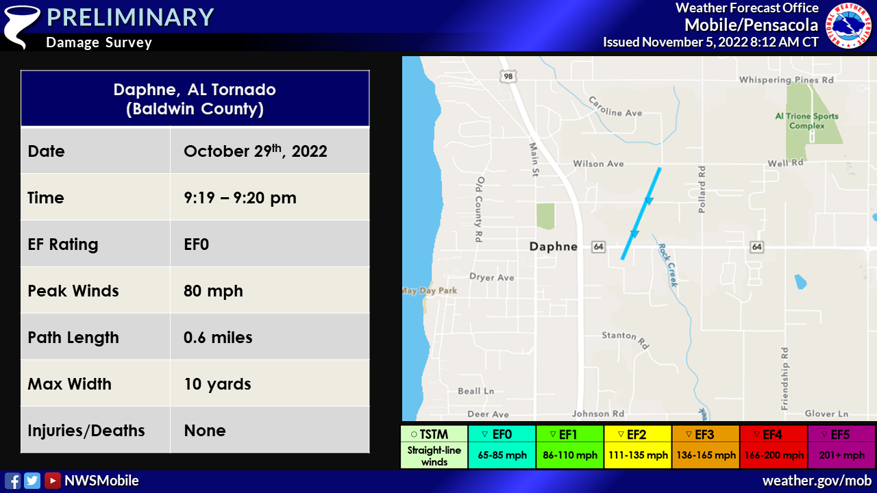
Daphne Tornado (Baldwin County, AL)
 Public Information Statement
National Weather Service Mobile AL
358 PM CDT Wed Nov 2 2022
...NWS Damage Survey for 10/29/22 Tornado Event Update #2...
Public Information Statement
National Weather Service Mobile AL
358 PM CDT Wed Nov 2 2022

...NWS Damage Survey for 10/29/22 Tornado Event Update #2...
.Daphne Tornado...

Rating:                 EF0
Estimated Peak Wind:    80 mph
Path Length /statute/:  0.6009 miles
Path Width /maximum/:   0.0 yards
Fatalities:             0
Injuries:               0

Start Date:             10/29/2022
Start Time:             09:19 PM CDT
Start Location:         1 E Daphne / Baldwin County / AL
Start Lat/Lon:          30.6028 / -87.894

End Date:               10/29/2022
End Time:               09:20 PM CDT
End Location:           1 NE Daphne / Baldwin County / AL
End Lat/Lon:            30.6108 / -87.8901

Survey Summary:
The tornado likely began south of Daphne Ave where light tree
debris was noted. Sporadic light wind damage was noted before
this location. The tornado then crossed Daphne Ave where it
brought down a couple hardwoods including a couple significant
snaps. However, the health of the trees were in question and
given the lack of other damage indicators, especially to
healthier trees, a lower bound damage rating was designated. A
convergent path was noted here. albeit weak, it was noticeable.
The tornado then crossed Randall Ave with some tree branches
snapped and one uproot. One home lost some shingles before the
tornado likely lifted north of Randall Ave.


&&

EF Scale: The Enhanced Fujita Scale classifies tornadoes into the
following categories:

EF0...Weak......65 to 85 mph
EF1...Weak......86 to 110 mph
EF2...Strong....111 to 135 mph
EF3...Strong....136 to 165 mph
EF4...Violent...166 to 200 mph
EF5...Violent...>200 mph

NOTE:
The information in this statement is preliminary and subject to
change pending final review of the events and publication in NWS
Storm Data.
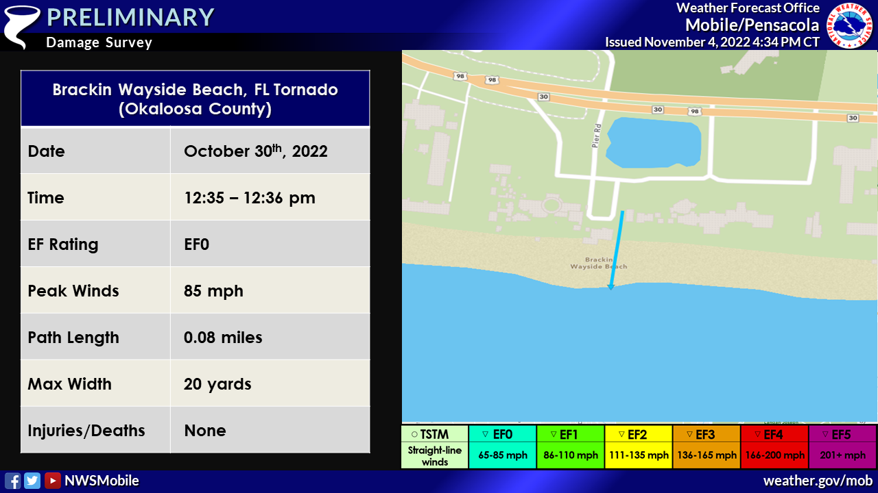
Brackin Wayside Beach Tornado (Okaloosa County, FL)
 Public Information Statement
National Weather Service Mobile AL
425 PM CDT Fri Nov 4 2022
...NWS Damage Survey for 10/29/22 through 10/30/22 Tornado
Event...
Public Information Statement
National Weather Service Mobile AL
425 PM CDT Fri Nov 4 2022

...NWS Damage Survey for 10/29/22 through 10/30/22 Tornado
Event...
..Brackin Wayside Beach Tornado...

Rating:                 EF0
Estimated Peak Wind:    85 mph
Path Length /statute/:  0.08 miles
Path Width /maximum/:   20.0 yards
Fatalities:             0
Injuries:               0

Start Date:             10/30/2022
Start Time:             12:35 PM CDT
Start Location:         2 SSE Cinco Bayou /  / FL
Start Lat/Lon:          30.393 / -86.5927

End Date:               10/30/2022
End Time:               12:36 PM CDT
End Location:           2 SE Cinco Bayou / Okaloosa County / FL
End Lat/Lon:            30.3943 / -86.5926

Survey Summary:
A waterspout moved onshore the afternoon of the 30th, tossing and
destroying a large shed based on numerous eyewitness reports and
video. The tornado was rated EF0 with winds up to 85mph. The
tornado dissipated quickly before reaching Highway 98.


&&

EF Scale: The Enhanced Fujita Scale classifies tornadoes into the
following categories:

EF0...Weak......65 to 85 mph
EF1...Weak......86 to 110 mph
EF2...Strong....111 to 135 mph
EF3...Strong....136 to 165 mph
EF4...Violent...166 to 200 mph
EF5...Violent...>200 mph

NOTE:
The information in this statement is preliminary and subject to
change pending final review of the events and publication in NWS
Storm Data.
Additional Information
Acknowledgements: Page created by Morgan Barry (Forecaster) and updated by Christina Leach (Forecaster) and Michael Mugrage (Forecaster).
LAST UPDATED: March 2024

