
Mid January Tornado Event
January 12, 2023
Summary of all Local Storm Reports (LSRs) on January 12th, as well as all the LSRs across the region for this event.
Storm survey teams preliminarily concluded that there were 3 tornadoes that occurred in our forecast area - one EF-2 tornado in Mobile County, AL, one EF-1 tornado in Crenshaw County, AL, and one EF-0 tornado in Conecuh County, AL. An additional EF-U tornado was discovered via high-resolution satellite imagery in Covington County, AL. The survey teams also found a swath of 60 to 90 mph straight line wind damage stretching from the I-65 corridor in Conecuh County to far southeastern Crenshaw County.
The data provided on this page are considered preliminary as we continue to analyze all available data. We will add more information to this page and social media as it becomes available. We thank you in advance for your patience.
----- IMPORTANT 2023 UPDATE -----
Significant updates were made to several tornado tracks and wind swaths impacting the NWS Mobile/Pensacola area in the 2018 to 2023 timeframe thanks to the introduction of high-resolution Sentinel, Worldview, and Planet satellite imagery. One or multiple tornado tracks/wind swaths listed on this event webpage were updated in 2023.
An updated graphic and details surrounding these significant updates can be found further down on this webpage in the section for that specific tornado track or wind swath. More information on this Local Tornado Reanalysis Project and a list of all updates can be found on our webpage at weather.gov/mob/TornadoReanalysis or the National Damage Viewer.
Here is a list of the significant updates:
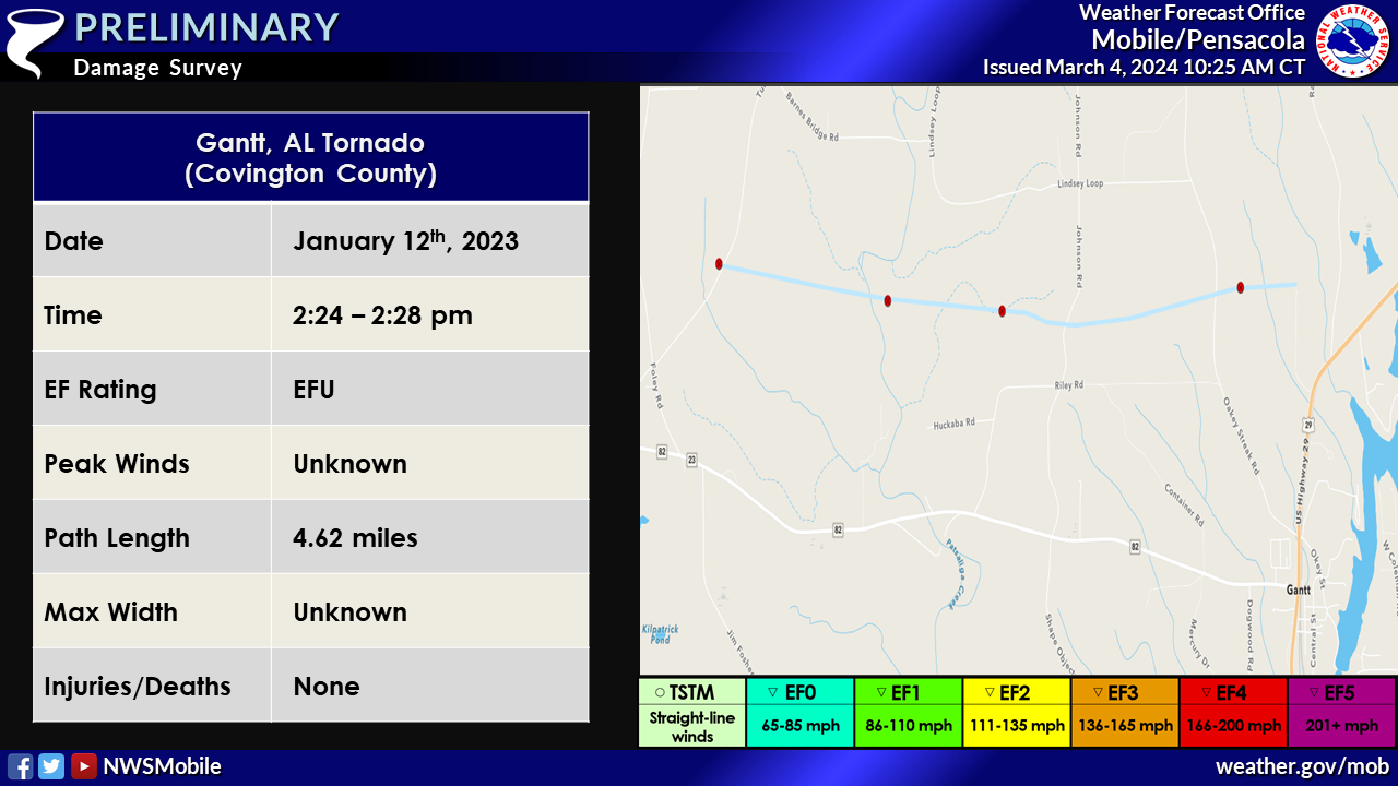
1. January 12, 2023 - New Tornado - Covington County, AL: A new EF-U tornado was discovered via Planet Satellite Imagery from the same supercell that spawned several other tornadoes along its track across the CWA on 1/12/2023. This tornado began near Turkey Creek Road carving a narrow path of intermittent tree damage eastward across Johnson Road and Oakey Streak Road. The tornado likely lifted just after this point where visible damage on satellite imagery becomes indiscernible. This tornado was given an EF-U rating given there was no available high-resolution imagery to reveal what types of DI's could be used.
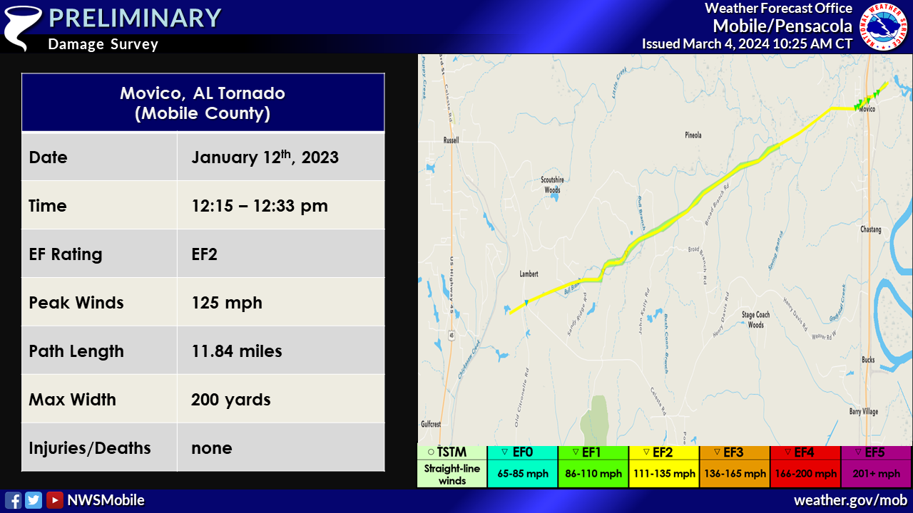
2. January 12, 2023 - Updated Tornado - Mobile County, AL: This tornado path received many cosmetic updates based on Planet and Worldview high-resolution satellite imagery. An additional region of EF2 strength tree damage was noted based on this satellite imagery north of Deer Wood Road where widespread trees were snapped and/or uprooted.
Northern Mobile County Tornado (Mobile County, AL)
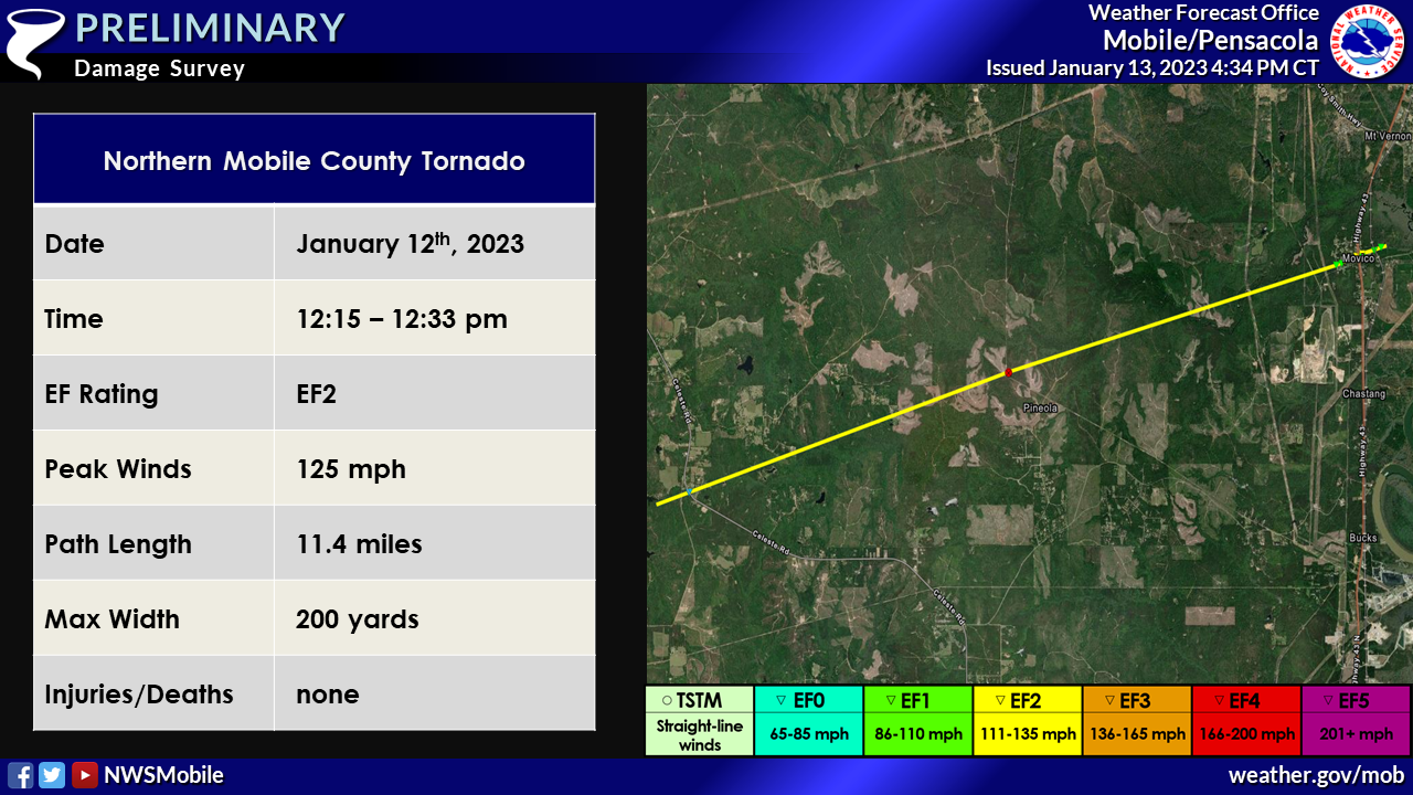
Public Information Statement
National Weather Service Mobile AL
431 PM CST Fri Jan 13 2023

...NWS Damage Survey for the 01/12/2023 Tornado Event...

..Northern Mobile County Tornado...

Rating:                 EF2
Estimated Peak Wind:    125 mph
Path Length /statute/:  11.4 miles
Path Width /maximum/:   200 yards
Fatalities:             0
Injuries:               0

Start Date:             01/12/2023
Start Time:             12:15 PM CST
Start Location:         1 SW Lambert / Mobile County / AL
Start Lat/Lon:          31.0196 / -88.203

End Date:               01/12/2023
End Time:               12:33 PM CST
End Location:           Movico / Mobile County / AL
End Lat/Lon:            31.0668 / -88.0183

Survey Summary:

The tornado is estimated to have touched down just west of Old
Citronelle Road or just east of U.S. Highway 45 near Gulfcrest.
The tornado likely continued along rural forested areas east of
Citronelle Road and Celeste Road that were inaccessible by the
survey team based on radar velocity and tornado debris signatures.
The survey team found evidence of snapped pine trees just
southwest of Movico Loop Road North. The tornado strengthened as
it crossed Movico Loop Road East causing significant softwood tree
snaps and uprooting of large hardwood trees. A double wide
manufactured home that was secured with straps rolled from its
foundation and was destroyed just west of U.S. Highway 43. This is
where the tornado reached peak intensity. The tornado then crossed U.S.
Highway 43 just north of Cedar Creek Landing Road where a single wide
manufactured home rolled from its foundation and was destroyed. The
survey team found large oak trees snapped in a convergent pattern
just to the north of where the manufactured home was destroyed. These
damage indicators suggest that the tornado reached peak EF2 intensity
with estimated winds around 125 mph and maximum width around 200 yards
near the intersection of U.S Highway 43 and Cedar Creek Landing Road.
Areal footage provided by Alabama Law Enforcement Agency indicates that
the path narrowed with some residual softwood snaps into the forest north
of Cedar Creek Landing Road before lifting.

This survey may be updated after high resolution satellite imagery becomes
available, particularly in regard to the tornado path in the inaccessible
area between Highway 45 and Highway 43.

&&

EF Scale: The Enhanced Fujita Scale classifies tornadoes into the
following categories:

EF0...Weak......65 to 85 mph
EF1...Weak......86 to 110 mph
EF2...Strong....111 to 135 mph
EF3...Strong....136 to 165 mph
EF4...Violent...166 to 200 mph
EF5...Violent...>200 mph

NOTE:
The information in this statement is preliminary and subject to
change pending final review of the event and publication in
NWS Storm Data.
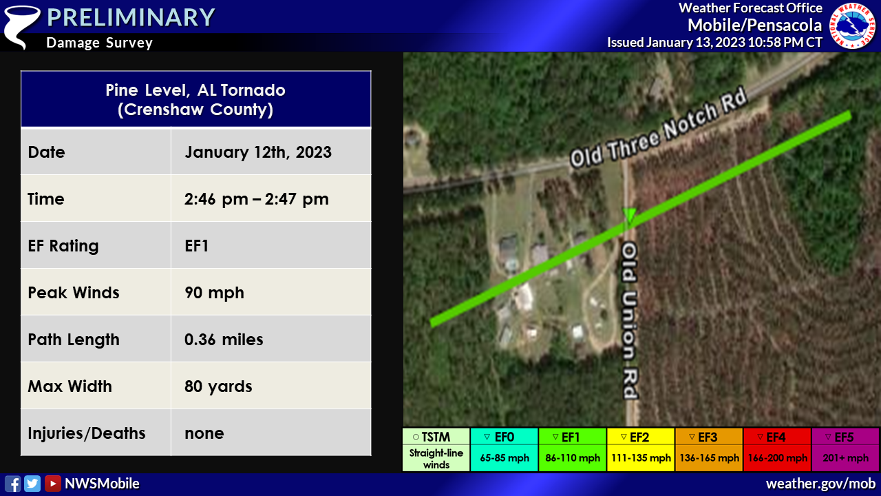
Pine Level, AL Tornado (Crenshaw County, AL)
 Public Information Statement
National Weather Service Mobile AL
701 PM CST Fri Jan 13 2023
...NWS Damage Survey for 01/12/2023 Tornado Event Update #1...
.Update... This update is to include storm surveys from Conecuh,
Covington, and Crenshaw Counties. Details are also provided about
a large swath of straight-line wind damage produced by one
supercell thunderstorm. Additional updates may be needed after
high resolution data becomes available and is analyzed.
Public Information Statement
National Weather Service Mobile AL
701 PM CST Fri Jan 13 2023

...NWS Damage Survey for 01/12/2023 Tornado Event Update #1...

.Update... This update is to include storm surveys from Conecuh,
Covington, and Crenshaw Counties. Details are also provided about
a large swath of straight-line wind damage produced by one
supercell thunderstorm. Additional updates may be needed after
high resolution data becomes available and is analyzed.
.Crenshaw County Tor...

Rating:                 EF1
Estimated Peak Wind:    90 mph
Path Length /statute/:  0.36 miles
Path Width /maximum/:   80 yards
Fatalities:             0
Injuries:               0

Start Date:             01/12/2023
Start Time:             02:46 PM CST
Start Location:         4 WNW Pine Level / Crenshaw County / AL
Start Lat/Lon:          31.505 / -86.2428

End Date:               01/12/2023
End Time:               02:47 PM CST
End Location:           3 WNW Pine Level / Crenshaw County / AL
End Lat/Lon:            31.5068 / -86.2372

Survey Summary:
The tornado touched down just west of Old Union Road and moved to
the northeast. As it crossed Old Union Road, it moved through a
grove of trees where dozens of trees were snapped or uprooted. It
continued briefly to the northeast for a tenth of a mile before
lifting.

Special thanks to the Crenshaw County EMA for their assistance
with this survey.

&&

EF Scale: The Enhanced Fujita Scale classifies tornadoes into the
following categories:

EF0...Weak......65 to 85 mph
EF1...Weak......86 to 110 mph
EF2...Strong....111 to 135 mph
EF3...Strong....136 to 165 mph
EF4...Violent...166 to 200 mph
EF5...Violent...>200 mph

NOTE:
The information in this statement is preliminary and subject to
change pending final review of the events and publication in NWS
Storm Data.
Nymph, AL Tornado (Conecuh County, AL)
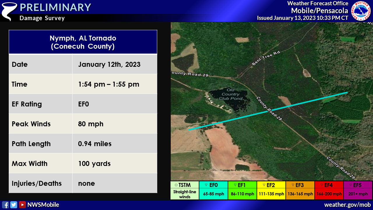
Public Information Statement
National Weather Service Mobile AL
701 PM CST Fri Jan 13 2023

...NWS Damage Survey for 01/12/2023 Tornado Event Update #1...

.Update... This update is to include storm surveys from Conecuh,
Covington, and Crenshaw Counties. Details are also provided about
a large swath of straight-line wind damage produced by one
supercell thunderstorm. Additional updates may be needed after
high resolution data becomes available and is analyzed.

.Conecuh County Tornado...

Rating:                 EF0
Estimated Peak Wind:    80 mph
Path Length /statute/:  0.94 miles
Path Width /maximum/:   100 yards
Fatalities:             0
Injuries:               0

Start Date:             01/12/2023
Start Time:             01:54 PM CST
Start Location:         2 N Nymph / Conecuh County / AL
Start Lat/Lon:          31.3616 / -86.9346

End Date:               01/12/2023
End Time:               01:55 PM CST
End Location:           2 NNE Nymph / Conecuh County / AL
End Lat/Lon:            31.3659 / -86.9195

Survey Summary:
The tornado briefly touched down approximately 3/4 of a mile east
of Nymph Road, where several large limbs were downed. It
continued to move to the east-northeast, crossing County Road 29,
where it uprooted several trees. The tornado lifted just
northeast of County Road 29.

Special thanks to the Conecuh County EMA for their assistance with
this survey.

&&

EF Scale: The Enhanced Fujita Scale classifies tornadoes into the
following categories:

EF0...Weak......65 to 85 mph
EF1...Weak......86 to 110 mph
EF2...Strong....111 to 135 mph
EF3...Strong....136 to 165 mph
EF4...Violent...166 to 200 mph
EF5...Violent...>200 mph

NOTE:
The information in this statement is preliminary and subject to
change pending final review of the event and publication in NWS
Storm Data.
Central Conecuh, Northern Covington, and Southern Crenshaw Counties Wind Event
 Public Information Statement
National Weather Service Mobile AL
701 PM CST Fri Jan 13 2023
...NWS Damage Survey for 01/12/2023 Tornado Event Update #1...
.Update... This update is to include storm surveys from Conecuh,
Covington, and Crenshaw Counties. Details are also provided about
a large swath of straight-line wind damage produced by one
supercell thunderstorm. Additional updates may be needed after
high resolution data becomes available and is analyzed.
Public Information Statement
National Weather Service Mobile AL
701 PM CST Fri Jan 13 2023

...NWS Damage Survey for 01/12/2023 Tornado Event Update #1...

.Update... This update is to include storm surveys from Conecuh,
Covington, and Crenshaw Counties. Details are also provided about
a large swath of straight-line wind damage produced by one
supercell thunderstorm. Additional updates may be needed after
high resolution data becomes available and is analyzed.
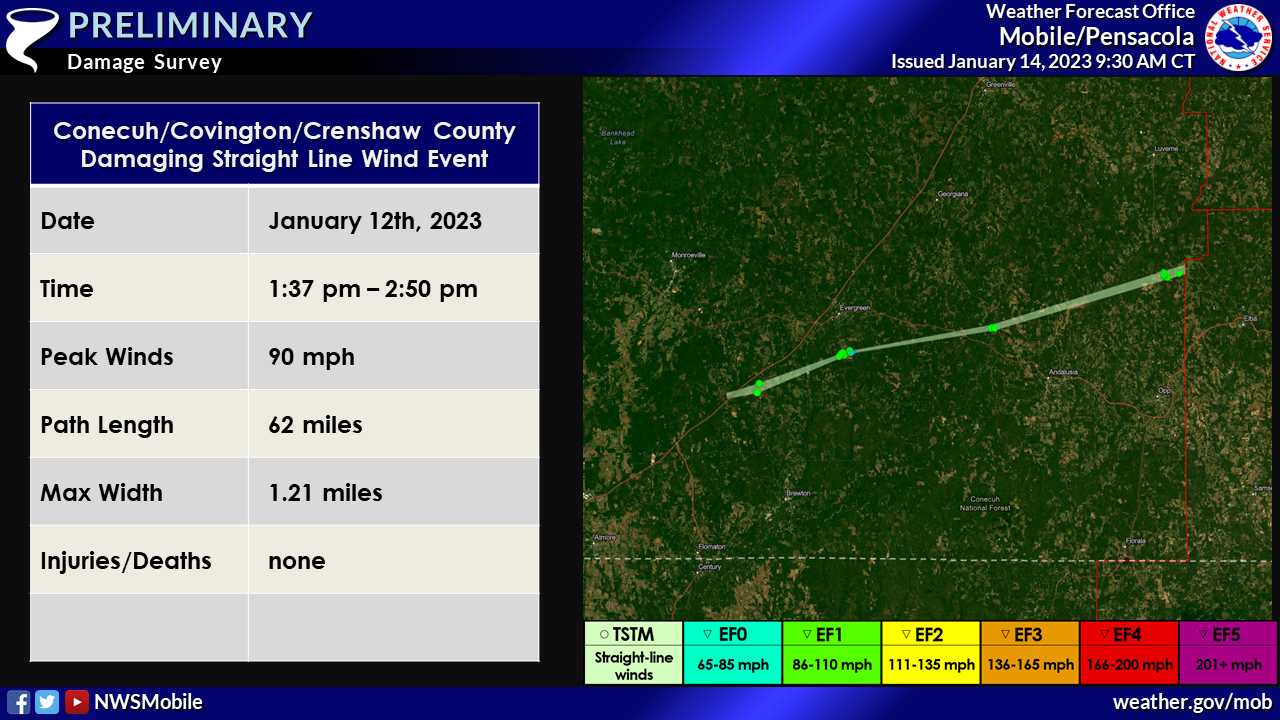
.Widespread Wind Damage...

A supercell thunderstorm progressed across south central Alabama
the afternoon of January 12th, 2023 from 1:40 PM CST through 2:50
PM CST. This supercell produced an extensive swath of sporadic to
widespread straight line wind damage along the path of its RFD
(Rear Flank Downdraft) through central Conecuh, northern
Covington, and southern Crenshaw Counties. Wind speeds were
estimated anywhere from 60 to 90 mph along its path. The wind
damage swath initially began near I-65 west of Castleberry,
continued east into Red Level and then eventually made its way
into far southeastern Crenshaw County. The most notable wind
damage was across southeastern Crenshaw County where numerous pine
trees were uprooted and/or snapped to the south of the tornado
path along Old Union Road. Irrigation equipment was also
overturned in this area. The swath of wind damage likely continued
east into Coffee County.

Special thanks to the Covington EMA, and Crenshaw and Conecuh
EMAs, for their assistance with this survey.
&&

NOTE:
The information in this statement is preliminary and subject to
change pending final review of the event and publication in NWS
Storm Data.
Additional Information
SPC Storm Report Archive
NWS Local Write-Ups and Webpages:
NWS Jackson
NWS New Orleans
NWS Birmingham
NWS Tallahassee
Acknowledgements: Page created and edited by Caitlin Baldwin (Forecaster) and Michael Mugrage (Forecaster).
LAST UPDATED: March 2024

