
February Long-Track Tornado Event
February 12, 2025
Summary of all Local Storm Reports (LSRs) from February 12th for the NWS Mobile/Pensacola area in addition to all the LSRs across the region for this event. Storm survey teams preliminarily concluded that at least 2 long-track tornadoes occurred in our forecast area during this event. The tally of tornadoes in our forecast area currently stands at:
ALABAMA: 1 tornado (EF-2)
MISSISSIPPI: 1 tornado (EF-3)
We plan to supplement the storm surveys with high-resolution satellite imagery as this becomes available in the coming days and weeks. The data provided on this page are considered PRELIMINARY as we continue to analyze all available data. We will add more information to this page and social media as it becomes available. We thank you in advance for your patience.
EVENT OVERVIEW
On the evening of February 12th, a tornado event unfolded across parts of southeast Mississippi and southwest Alabama. Two tornadoes occurred within the NWS Mobile/Pensacola area: an EF-3 tornado that tracked across much of northern Wayne County in Mississippi and an EF-2 tornado that moved through far eastern Washington County into Clarke County in Alabama. The EF-3 tornado in Wayne County was the strongest to affect the area since 1988.
Special thanks to MEMA for providing drone footage and imagery to supplement our ground surveys and a special thanks to NWS Jackson for assisting with the Wayne County tornado survey.
Wayne County Tornado (Wayne County, MS)
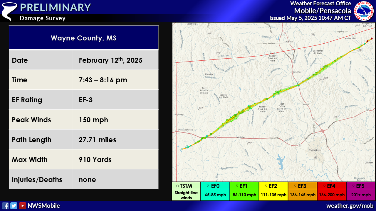
...NWS Damage Survey for 02/12/2025 Tornado Event...
.Wayne County Tornado...
Rating: EF3
Estimated Peak Wind: 150 mph
Path Length /statute/: 27.71 miles
Path Width /maximum/: 910 yards
Fatalities: 0
Injuries: 0
Start Date: 02/12/2025
Start Time: 07:43 PM CST
Start Location: 4 SSE Lightsey / Wayne County / MS
Start Lat/Lon: 31.6765 / -88.9308
End Date: 02/12/2025
End Time: 08:16 PM CST
End Location: 4 WSW Evansboro / Wayne County / AL
End Lat/Lon: 31.8656 / -88.5191
Survey Summary:
A powerful EF3 tornado occurred across Wayne County on the evening of February 12th. The tornado first touched down west of Pine Lane Ranch Road as an EF0 doing minor tree and structural damage. The tornado continued northeast, gradually widening and intensifying to EF1 intensity by the time it reached Highway 84. It then crossed Highway 84 as an EF1 snapping and uprooting multiple trees and continuing minor structural damage. Once the tornado crossed Van Hoover West Road, it destroyed the adjacent chicken houses while also continuing to do EF1 tree damage in the form of snaps and uproots. The next area that was surveyed was along Eucutta Road and Bunk Butler Road. Here the tornado widened substantially to a peak width of ~900 yards. Likewise, the tornado intensified significantly to EF3 intensity with peak winds around 150mph. Along Eucutta Road, multiple vortices were evident in emergency management provided drone imagery with several convergent damage tracks. In the most intense vortices, substantial tree and structural damage occurred. On Eucutta Road, a hardwood tree was completely stubbed with only the stubs of the largest branches remaining and at least 3 exterior walls of a home failed with anchor bolts off of Eucutta Road and Bunk Butler Road. As the tornado continued northeast it became quite intense resulting in near 100% deforestation in a quarter mile wide swath with all trees snapped low along with tree debarking and continued major structural damage. A recently constructed double wide home was completely removed from the property with the frame separated into multiple pieces and thrown roughly 100 to 300+ yards down track and deposited 20 to 30 feet up into the trees. Trees in the open field to the east were not only snapped but completely removed from their point of origin, likely deposited hundreds of yards north into the adjacent forest that was wiped out. EF3 magnitude forest damage with near 100% deforestation and debarking continued east through the north stretch of Bunk Butler Road. A barn, single wide, and double wide structure were completely destroyed and removed prior to the tornado crossing Bunk Butler Road for the second time. Some ground scouring was also noted here. Large metal supports from the double wide were scattered around and twisted, lifted and moved by about 150-200 yards from its origin. Two cattle trailers, an RV, and a pickup truck were tossed with the RV rolled about 50 yards. The tornado continued northeast across Bunk Butler Road once again and Leonard Street Road maintaining EF2 to EF3 magnitude tree and structural damage. The tornado gradually weakened to high end EF2 intensity as it moved across Beat 4 Shubuta Road nearly completely eradicating the forest and causing significant damage to homes, shifting a double wide home off its foundation and rotating it 45 degrees and removing 50% of the roof from another well-built home. After review of high-resolution satellite imagery some modifications to the tornado were made, particularly to locations along and northeast of Highway 45 in Wayne County. The first spot is near the river on the west side of Highway 45 in the vicinity of the railroad where EF2 tree damage occurred with numerous snaps and uproots of softwood trees. Further northeast the tornado varied in intensity. The tornado experienced a second peak in intensity along and just northeast of Pleasant Grove Chapparal Road where several sub-vortices within the parent tornado vortex caused extraordinary tree damage with near 100% deforestation of softwood forests in about a 250-yard-wide swath and notable tree damage in a 350-yard-wide swath. This secondary peak stretched about 2.5 miles in length over mostly densely forested regions. The tornado gradually shrunk in size and weakened back to EF1 intensity as it continued northeast. The threshold of visible forest damage could be seen east of John Allen Road, with the tornado likely lifting just prior to reaching Coyt Road where any visible damage becomes indistinguishable. The NWS Mobile would like to give a special thanks to NWS Jackson for assisting with this storm survey in addition to the Mississippi Emergency Management Agency for providing drone imagery of the hardest hit areas.
Tattlersville Tornado (Washington/Clarke County, AL)
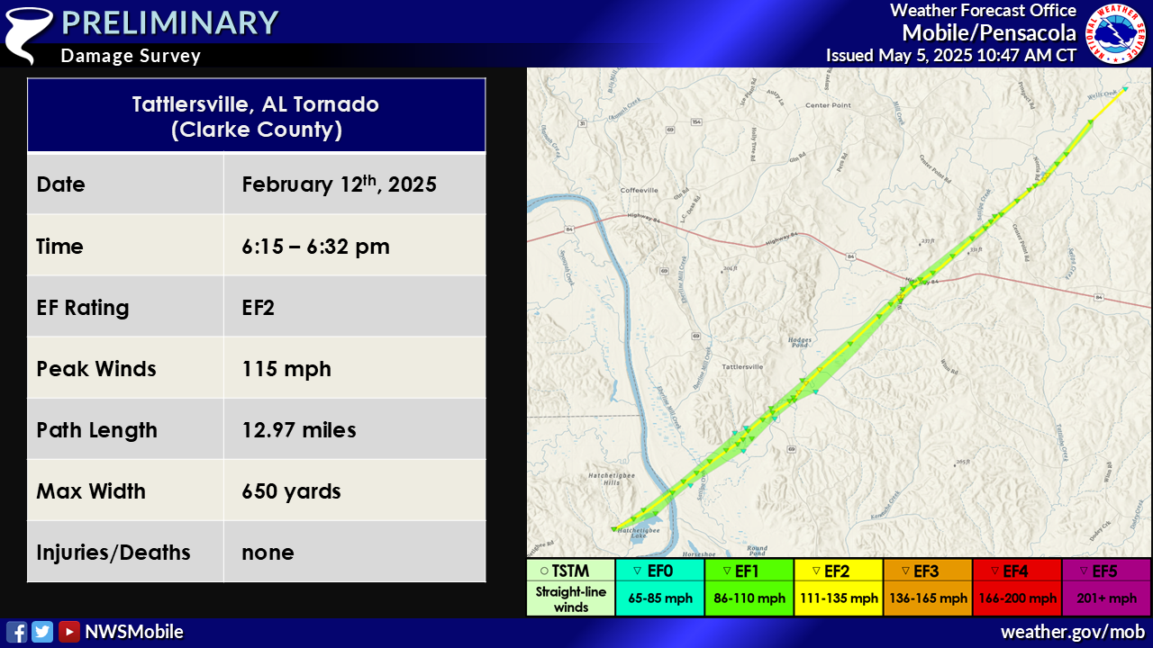
...NWS Damage Survey for 02/12/2025 Tornado Event...
.Tattlersville Tornado...
Rating: EF2
Estimated Peak Wind: 115 mph
Path Length /statute/: 12.97 miles
Path Width /maximum/: 650 yards
Fatalities: 0
Injuries: 0
Start Date: 02/12/2025
Start Time: 06:15 PM CST
Start Location: 3 SSW Tattlersville / Washington County / AL
Start Lat/Lon: 31.6664 / -88.0974
End Date: 02/12/2025
End Time: 06:32 PM CST
End Location: 3 S Mcentyre / Clarke County / AL
End Lat/Lon: 31.7935 / -87.9365
Survey Summary:
An EF2 tornado occurred just south of Coffeeville near Tattlersville. This tornado began on the west side of the Tombigbee River based on radar observed tornado debris signature. Prior to highway 69, high resolution satellite imagery revealed a substantial swath of EF1 tree damage with numerous convergent tree uproots in about a 650-yard-wide swath. The tornado first crossed Highway 69 where ground survey crew observed scattered to numerous trees snapped or uprooted. The tornado intensified as it went northeast quickly widening again to near 650 yards wide and beginning to produce EF2 tree damage between Highway 69 and Winn Road. Low end EF2 tree damage was observed by ground survey crew on Winn Road where many tree snaps occurred. The next road the tornado crossed was Center Point Road and Norris Road where multiple tree snaps were observed. The tornado briefly re-attained EF2 intensity with numerous tree snaps and uproots visible on high resolution satellite imagery between Norris Road and Reedy Hill Road. As the tornado approached and crossed Reedy Hill Road it gradually weakened, lifting just northeast of Reedy Hill Road.
EF SCALE: THE ENHANCED FUJITA SCALE CLASSIFIES TORNADOES INTO THE
FOLLOWING CATEGORIES:

EF0...WEAK......65 TO 85 MPH
EF1...WEAK......86 TO 110 MPH
EF2...STRONG....111 TO 135 MPH
EF3...STRONG....136 TO 165 MPH
EF4...VIOLENT...166 TO 200 MPH
EF5...VIOLENT...>200 MPH

NOTE:
THE INFORMATION IN THIS STATEMENT IS PRELIMINARY AND SUBJECT TO
CHANGE PENDING FINAL REVIEW OF THE EVENT AND PUBLICATION IN
NWS STORM DATA.
Additional Information
Acknowledgments: Page created by Michael Mugrage (Forecaster).
LAST UPDATED: May 2025

