
March 11th and 12th Spring Storm
Produces Several Brief Tornadoes
March 17, 2026
NWS Mobile storm survey teams concluded that there were at least 10 brief tornadoes that were spawned from the first significant Spring storm system for 2026 that rolled through the area late in the evening on Wednesday March 11th to shortly after midnight Thursday morning March 12th. 8 dropped down and impacted the interior and 2 in Mobile County. Of all, 8 tornadoes were rated EF1 and 2 were rated EF0. Please refer to the Local Storm Reports (LSRs) for March 11th and 12th, 2026 to view local and national storm reports.
We plan to supplement the storm surveys and analyze additional damage areas with high-resolution satellite imagery as it becomes available in the coming weeks. The data provided on this page are considered PRELIMINARY as we continue to analyze all available data. We will add more information to this page and social media as it becomes available. We thank you in advance for your patience.
Pleasant Grove Mississippi Tornado #1 (Wayne County, MS)

Public Information Statement
National Weather Service Mobile AL
1016 AM CDT Sat Mar 14 2026

...NWS Damage Survey for late evening March 11th Tornado Event...


.Pleasant Grove Tornado #1...

Rating:                 EF1
Estimated Peak Wind:    100 mph
Path Length /statute/:  1.07 miles
Path Width /maximum/:   75 yards
Fatalities:             0
Injuries:               0

Start Date:             03/11/2026
Start Time:             09:48 PM CDT
Start Location:         1 SSW Lightsey / Jones County / MS
Start Lat/Lon:          31.7187 / -88.9433

End Date:               03/11/2026
End Time:               09:50 PM CDT
End Location:           1 SSE Lightsey / Wayne County / MS
End Lat/Lon:            31.7154 / -88.9259

Survey Summary:
The first of three EF1 tornadoes within the Pleasant Grove area
began near or just before the Jones/Wayne County border along
Cleve Blackledge Road producing minor tree damage. The tornado
remained solely between Cleve Blackledge Road and Pleasant Grove
Road. It reached its strongest point just prior to reaching
Pleasant Grove Road where it caused significant tree damage
evident on Sentinel 2 satellite imagery. A small building to the
south of Cleve Blackledge Road also sustained significant damage
visible on the satellite imagery but was likely associated with
intense RFD winds rounding the south side of the tornado as
debris was thrown towards the southeast.
Pleasant Grove Mississippi Tornado #2 (Wayne County, MS)
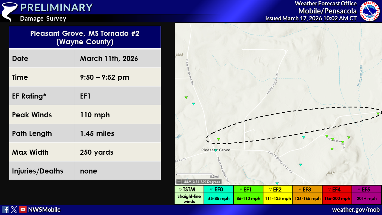
.Pleasant Grove Tornado #2...

Rating:                 EF1
Estimated Peak Wind:    110 mph
Path Length /statute/:  1.45 miles
Path Width /maximum/:   250 yards
Fatalities:             0
Injuries:               0

Start Date:             03/11/2026
Start Time:             09:50 PM CDT
Start Location:         2 SSE Lightsey / Wayne County / MS
Start Lat/Lon:          31.7103 / -88.9227

End Date:               03/11/2026
End Time:               09:52 PM CDT
End Location:           2 ESE Lightsey / Wayne County / MS
End Lat/Lon:            31.7146 / -88.8997

Survey Summary:
This is the second of three EF1 tornadoes within the Pleasant
Grove area, with the final two tornadoes featuring a unique
interaction as they continued to the east. This northernmost
tornado began north of the Old Highway 84 Loop and west of Harry
Pippen Drive where some trees were uprooted in a pond lying
towards the northwest. The southern extent of the tornado was
along Old Highway 84 Loop where a tree was lying towards the
east. Thorough review of Sentinel 2 satellite imagery revealed a
coherent damage track that crossed Pleasant Grove Altair Road,
ultimately merging with another tornado track that came in from
the southwest on Daniel Roney Drive. When these tornado tracks
came together, significant tree damage was observed along Daniel
Roney Drive with numerous snaps and uproots in a roughly 250 yard
wide swath. This tornado then remained the dominant one that
continued northeast before occluding due north across some
chicken farms along Pleasant Grove Altair Road with major loss of
roof paneling. No additional damage was noted north of the road,
with the tornado likely lifting after impacting the chicken
farms.
Pleasant Grove Mississippi Tornado #3 (Wayne County, MS)
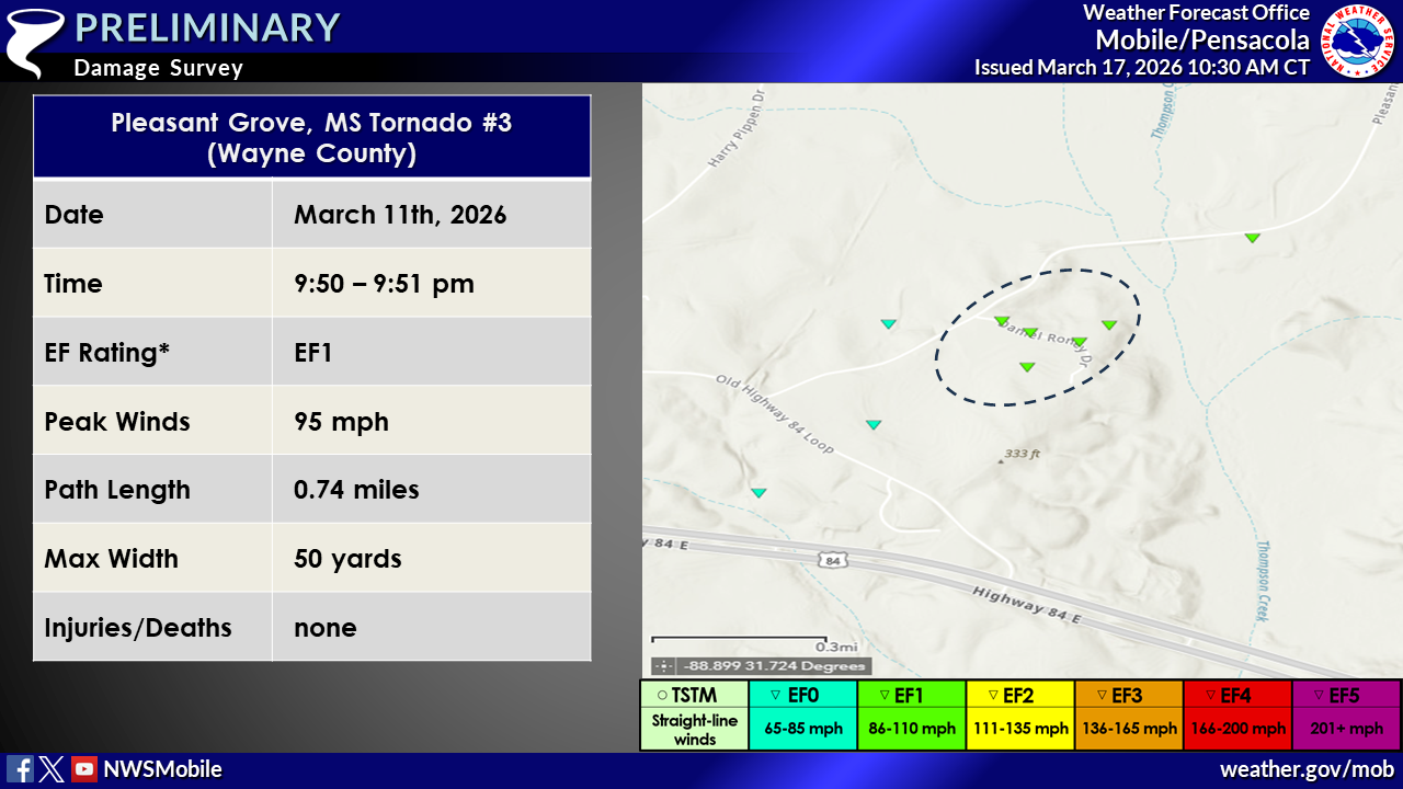
.Pleasant Grove Tornado #3...

Rating:                 EF1
Estimated Peak Wind:    95 mph
Path Length /statute/:  0.74 miles
Path Width /maximum/:   50 yards
Fatalities:             0
Injuries:               0

Start Date:             03/11/2026
Start Time:             09:50 PM CDT
Start Location:         2 SE Lightsey / Wayne County / MS
Start Lat/Lon:          31.7053 / -88.9142

End Date:               03/11/2026
End Time:               09:51 PM CDT
End Location:           2 SE Lightsey / Wayne County / MS
End Lat/Lon:            31.7113 / -88.904

Survey Summary:
This is the third of three EF1 tornadoes within the Pleasant
Grove area, with these final two tornadoes featuring a unique
interaction as they continued to the east. This southernmost
tornado began southwest of Old Highway 84 Loop causing minor
sporadic tree damage. The tornado intensified to EF1 intensity as
it began to cause more significant tree damage visible via
Sentinel 2 satellite imagery southwest of Daniel Roney Drive. The
tornado merged into the northern tornado path along Daniel Roney
Drive. Due to uncertainty on which tornado remained dominant
towards the northeast, this tornado track is estimated to have
ended just after crossing Daniel Roney Road as it turned
northward into the other tornado track. The peak width is also
estimated at approximately 50 yards based on the damage corridor
southwest of Daneil Roney Drive.
Isney Alabama Tornado (Choctaw County, AL)
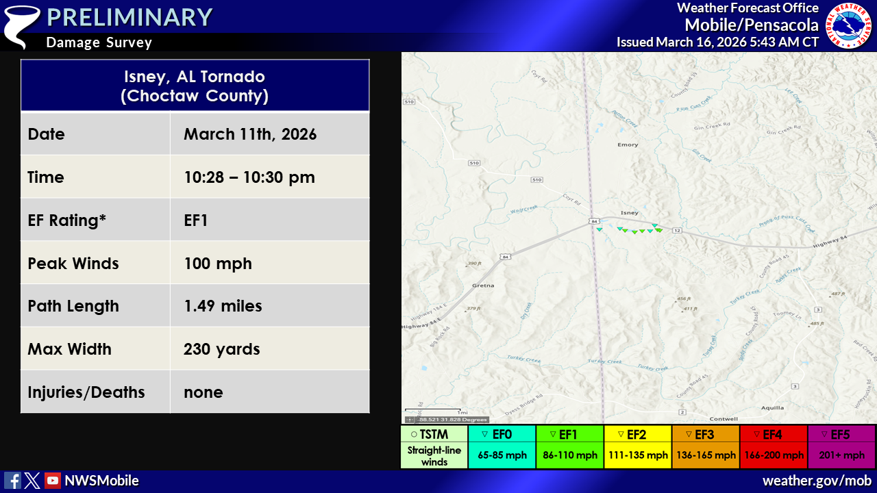
.Isney Alabama Tornado...

Rating:                 EF1
Estimated Peak Wind:    100 mph
Path Length /statute/:  1.49 miles
Path Width /maximum/:   230 yards
Fatalities:             0
Injuries:               0

Start Date:             03/11/2026
Start Time:             10:28 PM CDT
Start Location:         1 WSW Isney / Choctaw County / AL
Start Lat/Lon:          31.779 / -88.4662

End Date:               03/11/2026
End Time:               10:30 PM CDT
End Location:           1 E Isney / Choctaw County / AL
End Lat/Lon:            31.779 / -88.4412

Survey Summary:
The EF-1 tornado began just west of Wildflower Rd south of
highway 84 near Isney Alabama. The tornado resulted in a few
uprooted and snapped trees as it passed over Wildflower Rd. The
tornado reached its peak intensity likely between Wildflower Rd
and Poultry Rd where it snapped several softwoods, uprooted other
trees and did damage to several chicken farm buildings. Total
damage to the chicken farm was difficult to determine given the
buildings were already damaged from a prior storm but satellite
imagery was able to assist in determining there was at least some
new damage to the buildings. As a result peak intensity was given
to the tree damage and a lower bound estimate was given to the
chicken farm. The tornado then proceeded towards highway 84 as it
slowly weakened before crossing highway 84 near Lone Star Rd.
Souwilpa AL Tornado # 1 (Choctaw County, AL)

.Souwilpa Alabama Tornado #1...

Rating:                 EF1
Estimated Peak Wind:    90 mph
Path Length /statute/:  0.16 miles
Path Width /maximum/:   35 yards
Fatalities:             0
Injuries:               0

Start Date:             03/11/2026
Start Time:             10:42 PM CDT
Start Location:         1 NE Souwilpa / Choctaw County / AL
Start Lat/Lon:          31.8276 / -88.3143

End Date:               03/11/2026
End Time:               10:43 PM CDT
End Location:           1 NE Souwilpa / Choctaw County / AL
End Lat/Lon:            31.8294 / -88.3127

Survey Summary:
The brief EF-1 tornado began along Souwilpa road near Alabama
Highway 187 where it uprooted and snapped a couple of trees. A
very narrow convergence path was noted as it crossed highway
17 peaking in intensity as it snapped a few small softwood pines
before likely dissipating in the woods east of highway 17.
Souwilpa AL Tornado # 2 (Choctaw County, AL)
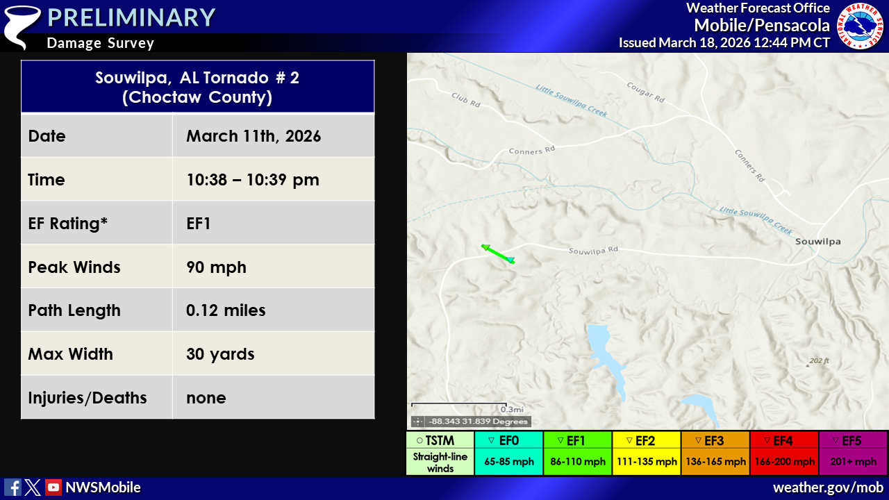
.Souwilpa Alabama Tornado #2...

Rating:                 EF1
Estimated Peak Wind:    90 mph
Path Length /statute/:  0.12 miles
Path Width /maximum/:   30 yards
Fatalities:             0
Injuries:               0

Start Date:             03/11/2026
Start Time:             10:38 PM CDT
Start Location:         1 W Souwilpa / Choctaw County / AL
Start Lat/Lon:          31.8192 / -88.3473

End Date:               03/11/2026
End Time:               10:39 PM CDT
End Location:           1 WSW Souwilpa / Choctaw County / AL
End Lat/Lon:            31.8182 / -88.3456

Survey Summary:
This short EF-1 tornado began just north of Souwilpa road
resulting in a couple softwood trunk snaps before crossing
Souwilpa road resulting in a couple uprooted trees and destroying
an outbuilding that was pulled southward towards the path. A
large oak was uprooted before the short tornado dissipated into
the woods. Peak intensity was likely around 90 mph based on the
uproots and snapped trunks.
Greene County Mississippi Tornado
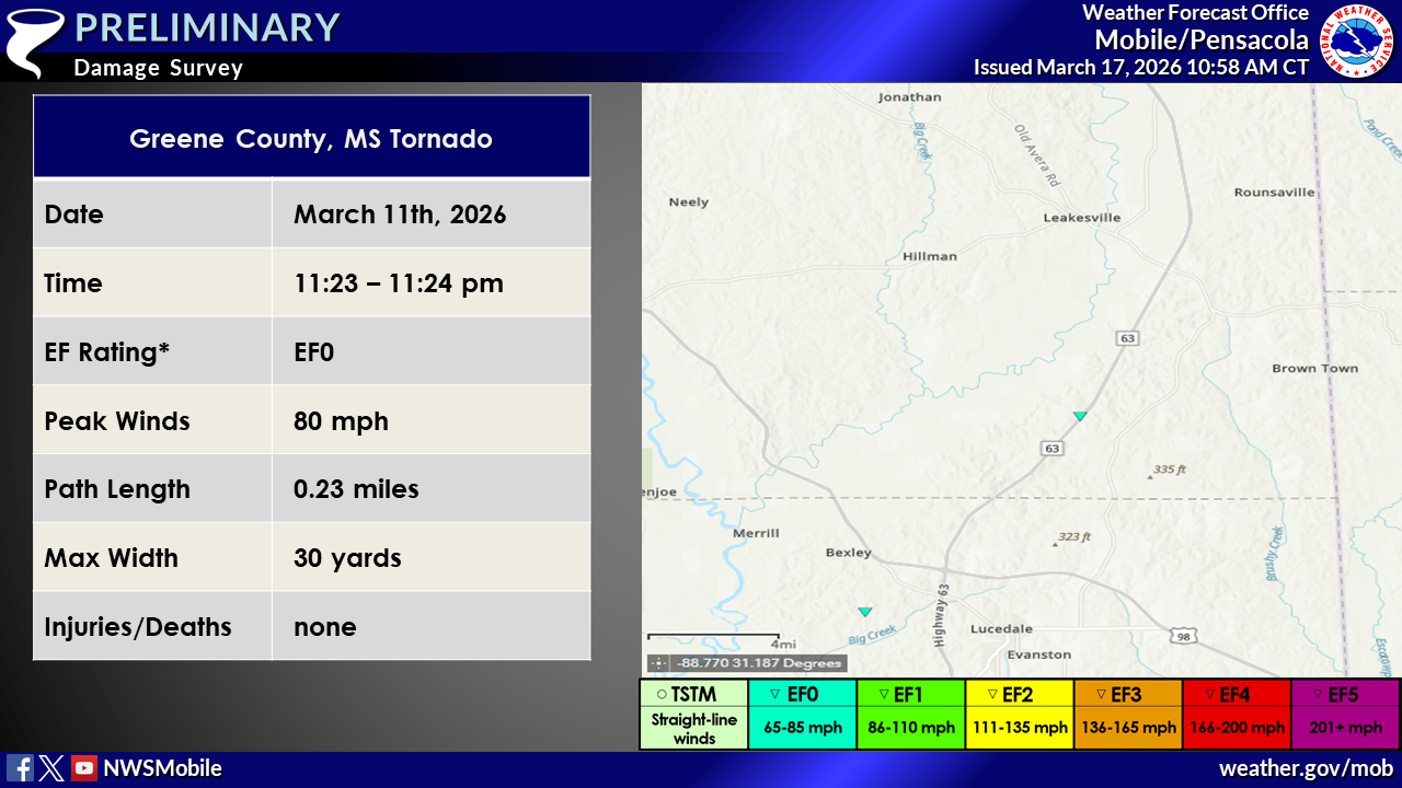
.Greene County MS Tornado...

Rating:                 EF0
Estimated Peak Wind:    80 mph
Path Length /statute/:  0.23 miles
Path Width /maximum/:   30 yards
Fatalities:             0
Injuries:               0

Start Date:             03/11/2026
Start Time:             11:23 PM CDT
Start Location:         6 SW Pisgah / Greene County / MS
Start Lat/Lon:          31.0446 / -88.5574

End Date:               03/11/2026
End Time:               11:24 PM CDT
End Location:           5 SW Pisgah / Greene County / MS
End Lat/Lon:            31.043 / -88.5541

Survey Summary:
A weak and small EF-0 tornado occurred in the woods just west of
highway 63 just north of Jake Hill Rd. A tree was uprooted and a
few large branches snapped off along highway 63 as it crossed the
road. The tornado likely dissipated just east of highway 63.
Georgetown AL Tornado # 1 (Mobile County, AL)
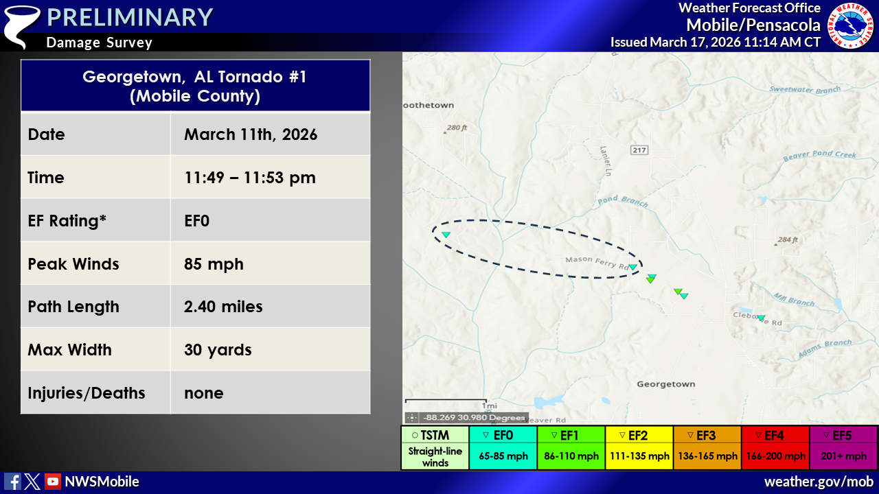
.Georgetown Alabama Tornado #1...

Rating:                 EF0
Estimated Peak Wind:    85 mph
Path Length /statute/:  2.40 miles
Path Width /maximum/:   30 yards
Fatalities:             0
Injuries:               0

Start Date:             03/11/2026
Start Time:             11:49 PM CDT
Start Location:         2 SSE Boothetown / Mobile County / AL
Start Lat/Lon:          30.9222 / -88.3352

End Date:               03/11/2026
End Time:               11:53 PM CDT
End Location:           3 SE Boothetown / Mobile County / AL
End Lat/Lon:            30.9149 / -88.2958

Survey Summary:
The EF-0 tornado began along Mason Ferry Rd west of Georgetown
Alabama where it resulted in a few large branches snapped. The
tornado continued through the forest on the north side of Mason
Ferry rd before reaching McDavid rd where large branches and a
large softwood tree was uprooted in a clear convergent pattern.
This is likely where the tornado ended. The tornado may have
reached peak intensity within the woods; however, the peak
intensity that survey crews were able to find was around 85 mph.
Georgetown AL Tornado # 2 (Mobile County, AL)

.Georgetown Alabama Tornado #2...

Rating:                 EF1
Estimated Peak Wind:    90 mph
Path Length /statute/:  1.57 miles
Path Width /maximum/:   110 yards
Fatalities:             0
Injuries:               0

Start Date:             03/11/2026
Start Time:             11:53 PM CDT
Start Location:         4 SE Boothetown / Mobile County / AL
Start Lat/Lon:          30.9124 / -88.2944

End Date:               03/11/2026
End Time:               11:56 PM CDT
End Location:           4 WSW Chunchula / Mobile County / AL
End Lat/Lon:            30.9035 / -88.2704

Survey Summary:
The EF-1 tornado began south of Mason Ferry Rd just south of
McDavid Rd. The start point was difficult to determine as the end
point of another tornado and the start point of this tornado were
close in proximity to each other. However, convergence patterns
and radar analysis did suggest that these were indeed two
separate tornadoes rather than one tornado. The tornado snapped a
couple of softwood trunks and continued sporadically uprooting
trees as it approached Brothers Lake Club Rd where it reached
peak intensity of 90 mph near and around Brothers Lake Club Rd.
The tornado then crosses Mason Ferry Rd and tracked into the
forest before crossing Alabama 217 and finishing near Cleborne
Rd.
Poarch Creek Reservation Tornado (Escambia County, AL)
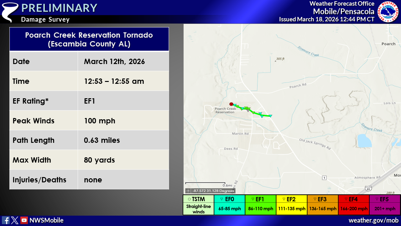
.Poarch Creek Reservation Tornado...

Rating:                 EF1
Estimated Peak Wind:    100 mph
Path Length /statute/:  0.63 miles
Path Width /maximum/:   80 yards
Fatalities:             0
Injuries:               0

Start Date:             03/12/2026
Start Time:             12:53 AM CDT
Start Location:         1 WNW Poarch Creek Reservation / Escambia County / AL
Start Lat/Lon:          31.1065 / -87.5664

End Date:               03/12/2026
End Time:               12:55 AM CDT
End Location:           Poarch Creek Reservation / Escambia County / AL
End Lat/Lon:            31.1035 / -87.5565

Survey Summary:
A brief EF1 tornado impacted the Poarch Creek Indian Reservation.
This tornado began in the adjacent field to the Poarch Creek
Indians Gym, first taking the scoreboard and tossing the heavy
half 200 yards downstream and the lighter half being tossed into
the adjacent field`s scoreboard approximately 500 yards away. The
tornado then impacted the gym lifting up a significant portion of
the roofing material on the west-facing side. On the east side of
the gym, a short power pole was snapped along with most of the
roofing material being deposited into the netting adjacent to the
next field in its path adjacent to the parking lot. The tornado
continued to the east-southeast, reaching its strongest point
prior to crossing Lynn McGhee Drive where it snapped numerous
small hardwood trees and pushed over several road signs. This is
also where the tornado reached its peak width at approximately
80 yards. After crossing Lynn McGhee Drive and Green Road, a
softwood tree was snapped mid trunk with a large amount of small
tree debris and limbs scattered across the adjacent field. The
tornado continued weakening as it moved southeast and then east
across Creek Drive, causing minor roofing and siding damage to
buildings. The last visible damage point was along Jack Springs
Road where a large oak tree was uprooted facing east-southeast.
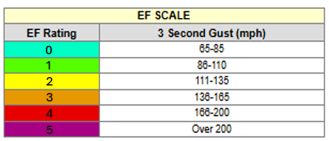
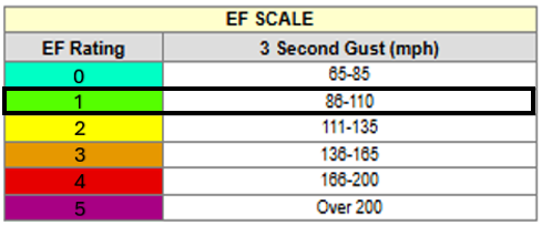
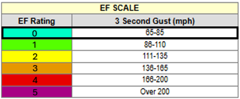
The Enhanced Fujita (EF) Scale classifies tornadoes into the following categories:


NOTE: THE INFORMATION ON THIS PAGE IS PRELIMINARY AND SUBJECT TO
CHANGE PENDING FINAL REVIEW OF THE EVENTS AND PUBLICATION IN
NWS STORM DATA.
NOTE: THE INFORMATION ON THIS PAGE IS PRELIMINARY AND SUBJECT TO
CHANGE PENDING FINAL REVIEW OF THE EVENTS AND PUBLICATION IN
NWS STORM DATA.
Additional Information
LAST UPDATED: March 17 2026

