August 2018 Graphical Climate Summaries
Mobile Alabama and Pensacola Florida Area
National Weather Service Mobile Alabama
September 8, 2018
August 2018 in Review - Outside of a few days where rain kept the daily highs well below normal for August at both Mobile and Pensacola, temperatures were very close to seasonal normals. No record temperatures occurred. It was a fairly dry month at Mobile where rainfall was well over 2 inches below monthly normal, while slightly above normal rainfall was observed at Pensacola.
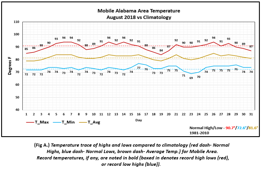
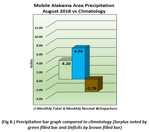
Mobile Alabama Area - The average monthly high was 90.2° or 0.5° below normal. The average monthly low was 73.5° or 0.9° above normal. The average monthly temperature was 81.8° or 0.2° above normal. (Fig. A) shows how temperatures compared to the seasonal normal monthly highs and lows, which are shown by the colored dashed lines. August rainfall measured 4.20" or 2.76" below normal (Fig. B). The total rainfall year to date (Not graphically shown) now stands at 40.38" or 6.78" below normal.
Click on the Mobile Alabama area climate graphics below to expand:
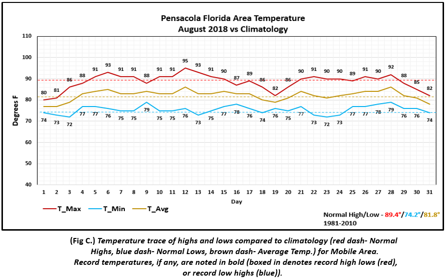
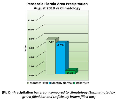
Pensacola Florida Area - The average monthly high was 88.6° or 0.8° below normal. The average monthly low was 75.5° or 1.3° above normal. The average monthly temperature was 82.1° or 0.3° above normal. (Fig. C) shows how temperatures compared to the seasonal normal monthly highs and lows, which are shown by the colored dashed lines. August rainfall measured 7.54" or 0.78" above normal (Fig.D). The total year to date total rainfall(Not graphically shown) now stands at 45.84" or 1.07" above normal.
Click on the Pensacola Florida area climate graphics below to expand:
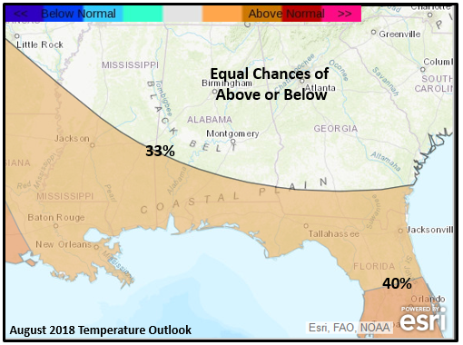
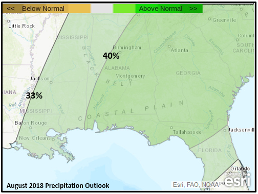
Outlook for September:
Unseasonal warmth is favored over the coastal plain for the month. Precipitation is favored to be above normal over the southeast, west to across the coastal plain. Further north over the Lower Mississippi River Valley, equal chances of above or below normal precipitation is favored. (Graphics courtesy of CPC and esri)
Click on the graphics below to expand:
Below are September average temperatures and normal precipitation values for a few select sites:
Mobile Alabama Area - Average Monthly High 87.0° Average Monthly Low 68.0° Average Precipitation 5.11"
Pensacola Florida Area - Average Monthly High 86.5° Average Monthly Low 70.3° Average Precipitation 5.98"
Evergreen Alabama - Average Monthly High 87.3° Average Monthly Low 63.8° Average Precipitation 4.03"
Waynesboro Mississippi - Average Monthly High 86.3° Average Monthly Low 64.9° Average Precipitation 4.14"
Climate Prediction Center's Interactive Long Range Outlooks
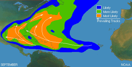
Heading into the Peak of the 2018 Atlantic Basin Hurricane Season:
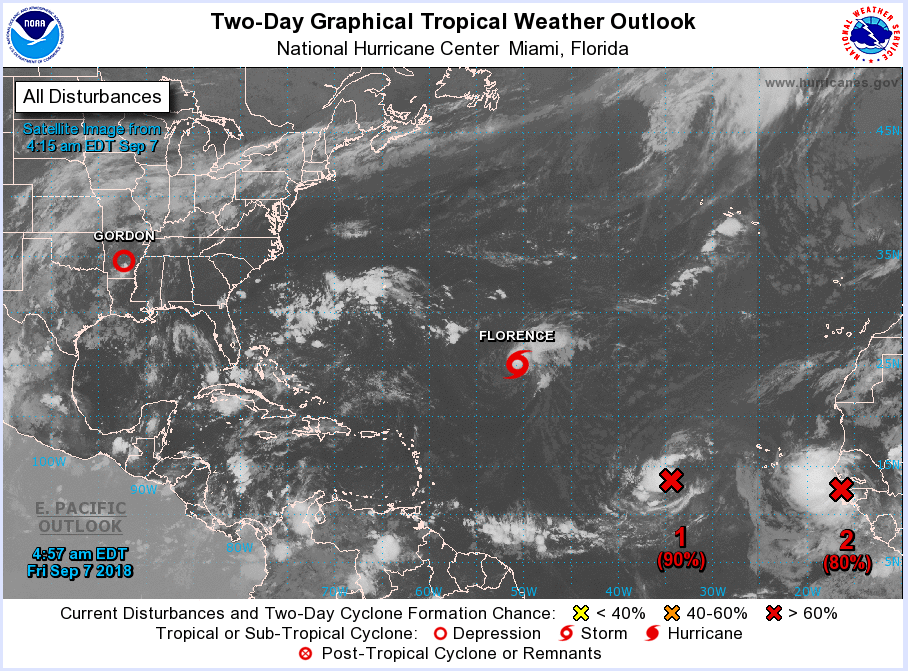
We are now moving into the month when tropical cyclone activity begins to peak. During the month of September tropical cyclone activity origin can occur anywhere from off the west coast of northern Africa and points west. Storms most likely to develop or move up across the western Atlantic and from the northwest Caribbean, up into the Gulf. A snap shot of the morning tropical weather outlook on Friday September 7th, below, does indeed show a potential ramp up in activity moving into favored areas for development. Although Gordon has lifted north of the area, eyes will be focused to the east and southeast over the next few weeks. To see the latest long range outlooks by the National Hurricane Center, see the following link: https://www.nhc.noaa.gov/gtwo.php?basin=atlc&fdays=5
Click on the graphics below to expand:
Additional Climate Links:
The links below are intended to provide additional climate information, education and outlooks. The National Weather Service Mobile Alabama's Climate and Past Weather page provides climate data at your fingertips for many observation points in the local forecast area by accessing the NOWData tab as well as many other climate resources. The Climate Prediction Center Link provides short and longer range climatic outlooks and education about the larger scale global circulations that impact temperatures and weather. With the large agriculture and farming presence along the central Gulf coast, the Drought Monitor link provides updates on drought trends and impacts. Another very helpful resource is the Community Collaborative Rain Hail and Snow (CoCoRaHS) network, which is a large group of volunteers working together to measure and map precipitation (rain, hail and snow). The aim of CoCoRaHS is to provide the highest quality data for natural resource, education and research applications. You can be a part of the CoCoRaHS team by becoming a volunteer rainfall observer. To learn more click on the CoCoRaHS link below.
National Weather Service Mobile AL Climate and Past Weather
Climate Prediction Center (CPC)
CoCoRaHS Network Water Year Summaries