Moderate to Severe Drought Changes Little Over the Gulf Coast
Joe Maniscalco - Meteorologist/Forecaster/Climate Program Lead
National Weather Service Mobile Alabama
May 29, 2020
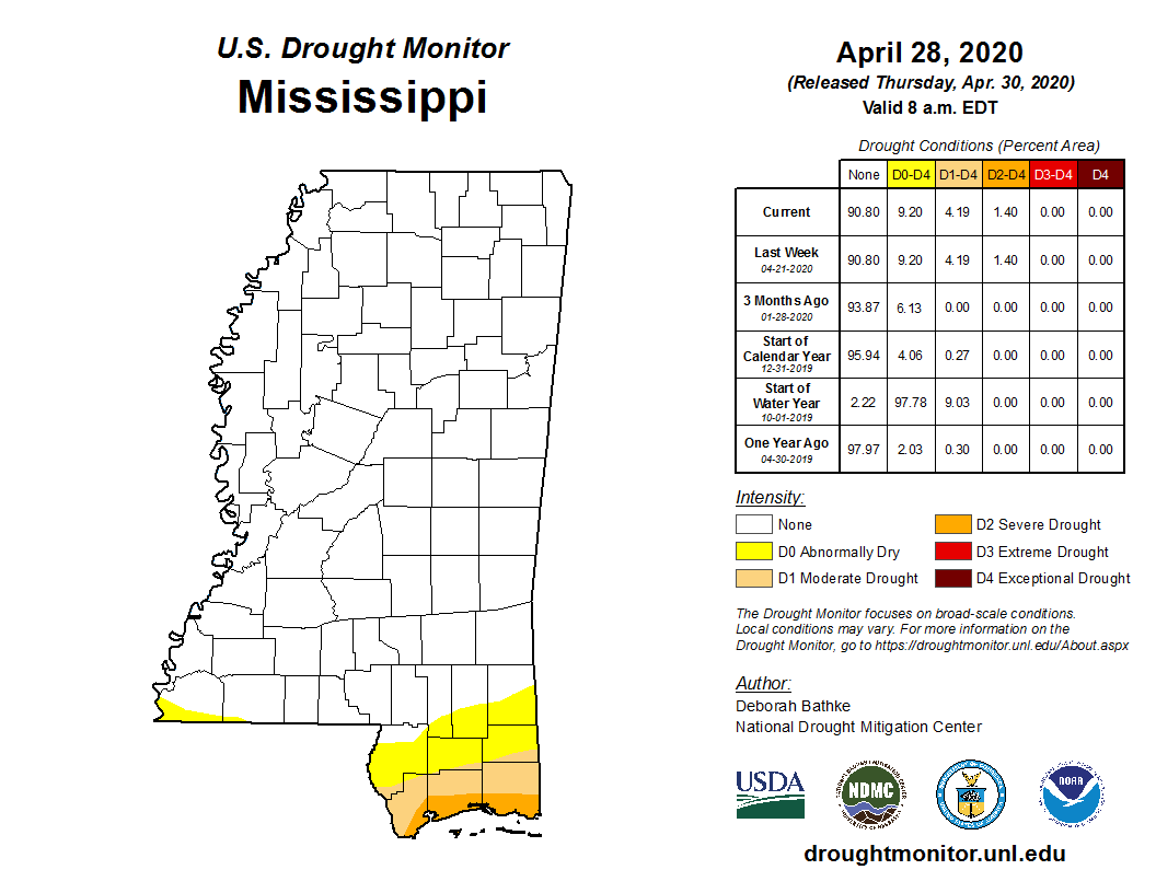
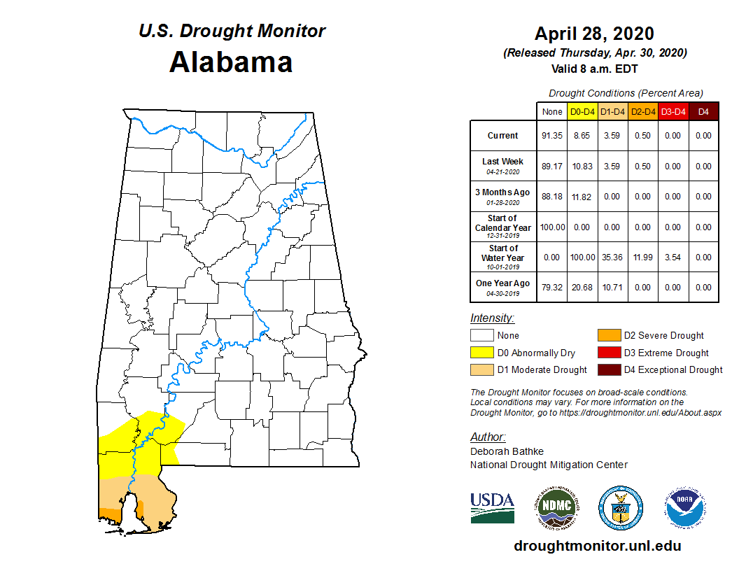
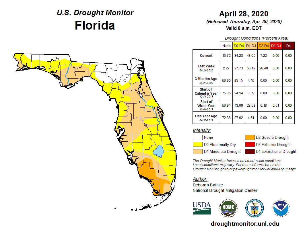
Discussion - The latest U.S. Drought Monitor indicates very little
change. Mobile and Baldwin counties, eastward to much of the
northwest Florida Panhandle remains in moderate to severe drought.
This also includes the surrounding land areas up to where the Mobile,
Tombigbee and Alabama Rivers merge. Elsewhere, abnormally dry
conditions continue up along and south of US Highway 84.

The Drought Monitor classifies drought within
one of these five categories:

D0...Abnormally Dry
D1...Moderate Drought
D2...Severe Drought
D3...Extreme Drought
D4...Exceptional Drought
Click on the State Maps to See Drought Trends Over Past Several Weeks:
|
|
|
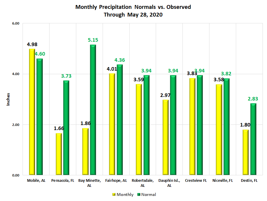
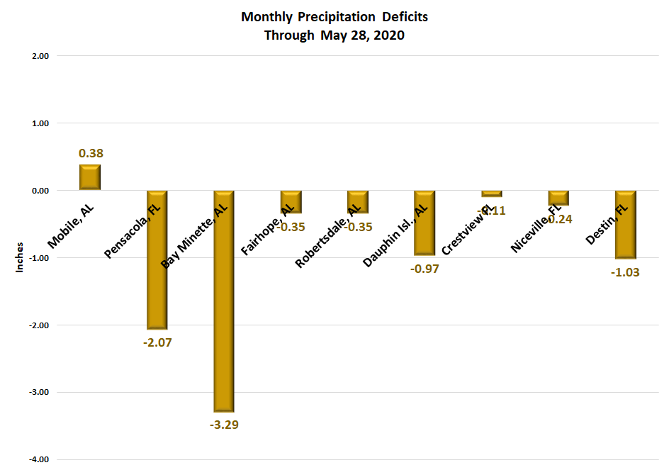
Over the week spanning Thursday May 21st to May 28th, the Mobile area
was two inches below monthly normal rainfall up to the 25th.
Following was a more unsettled weather pattern for the latter few
days of the period which saw more in the way of scattered to
numerous storms providing enough rain to exceed normal.
The Pensacola area though was too far to the south of the rains this
period as monthly rainfall deficits are a little over two inches. A
few other areas over southwest and south central Alabama to
portions of the western Florida saw periods of excessive rain, but
these were in isolated areas and did little to change the widespread
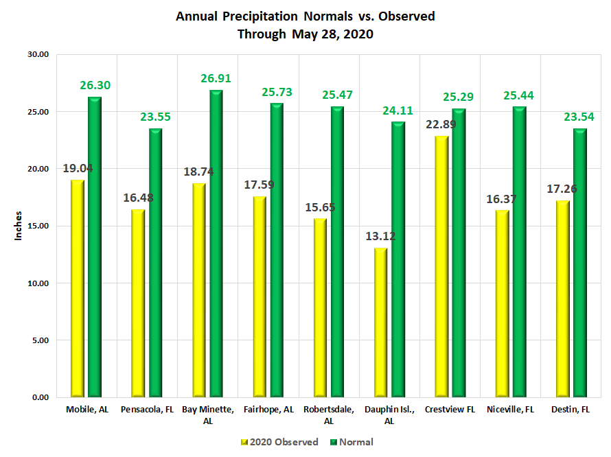
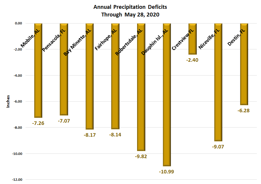
drought problems. Annual rainfall deficits remain notable in
moderate to severe drought areas, ranging mostly 6 to 10 inches
below what forecasters would otherwise expect this time of year.
Click on the Precipitation Graphics Below for a More Detailed Look at Local Precipitation
Across the Area:
|
|
|
|
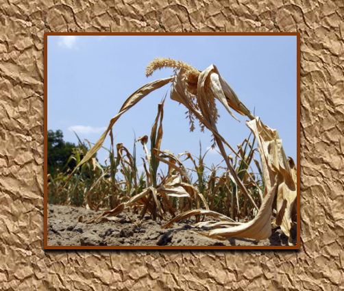
Agricultural Impacts - With little change in drought conditions,
stress on livestock continues. Crop growth stress is increased
due to topsoil moisture levels being short to very short. For the
week ending May 24th, the latest information from the US Department
of Agriculture (USDA) shows 18% of the state of Alabama experiencing
topsoil moisture deficits. 32% of the state of Florida is topsoil
moisture deficient and Mississippi has increased to 24% deficient.
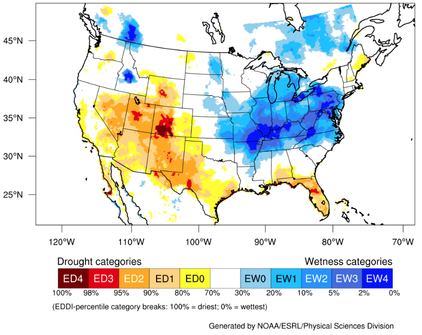
The latest 1-Month Evaporative Demand Drought Index (EDDI) is provided below.
EDDI is a drought monitoring and early warning guidance tool. It examines how
anomalous the atmospheric evaporative demand (known as "the thirst
of the atmosphere") is for a given location and across a time period of interest.
EDDI can offer early warning of agricultural drought, hydrologic drought, and
fire-weather risk by providing near-real-time information on the emergence or
persistence of anomalous evaporative demand in a region. A particular
strength of EDDI is in capturing the precursor signals of water stress
at weekly to monthly timescales, which makes EDDI a strong tool for
preparedness for both flash droughts and ongoing droughts. For more
information on EDDI, visit the Physical Sciences Laboratory link here
for additional information.
Fire - Under Department of Environmental
Management (ADEM) regulations, non-agricultural burns are not
allowed during the months of May through October for Mobile and
Baldwin counties. In an effort to uphold these restrictions, the
AFC does not issue burn permits for miscellaneous burns or for land
clearing in these counties. Contact ADEM at 334-271-7879 for more
information.

As of May 27th, the fire danger risk is very high over Okaloosa
county where burn bans remain in effect. The fire danger risk is low
for Escambia and Santa Rosa counties. For additional information,
please contact your local city or county for specific information on
rules or ordinances that must be adhered to regarding fire.
Additional links for fire information -
Florida
Florida Forest Service
Wildfire Conditions/Burn Bans
Florida Forest Service Active Wildfire Points Dashboard
Florida Forest Service Wildfire Map
Alabama
Fire Danger Advisory
Alabama Forestry Commission
Alabama Wildfire Map
Mississippi
Burn Bans
Mississippi Forestry Commission
NOAA/NESDIS/OSPO Fire and Smoke Analysis Product
Societal Impacts - Water conservation techniques are encouraged
to be followed in drought areas. Increase in air-borne allergens
likely to create problems for respiratory sensitive groups.
Hydrology- With recent rains north of I-10, creeks and river systems in the
moderate to severe drought areas have shown improvement in flow, trending
from below normal on the last statement to now mostly normal at several
sites. Below is a listing of flow and stages for select creeks and river systems.
Stream-Flow Links (USGS)
Mississippi
Alabama
Florida
Precipitation Outlook- The longer range outlook favors a transition
to a more typical summer-time precipitation pattern mostly focused
along the afternoon coastal sea-breeze. Although some storms will be
capable of producing locally heavy downpours, the duration of storms
is anticipated to be short over any one area. Thus, areal drought
improvement in the shorter-term is not expected through the
beginning of June. To see all of the latest short and longer range
forecasts and outlooks regarding precipitation and drought refer to the
Weather Prediction Center and Climate Prediction Center.
Additional Drought Links-

NWS Mobile/Pensacola |
|

Information System |
Acknowledgements: Page created by Joe Maniscalco (Forecaster/Climate Program Lead). Thanks to Morgan Barry (Forecaster) for insight in developing animated gifs used in this page. The National Weather Service also wishes to thank all of our emergency management partners, first responders and fire weather agencies during this season of fire. A thank you also goes out to all NWS COOP observers and citizen rainfall networks for providing daily rainfall observations. Climate Prediction Center, Physical Sciences Laboratory, USGS, USDA, state forestry departments/commissions, Drought Mitigation services, NIDIS, and ADEM,
LAST UPDATED: May 29, 2020

