
Dangerous and extreme heat will remain across portions of the Central U.S. this week, persisting across the Mid to Lower Mississippi Valleys, Gulf Coast, Southern Plains and portions of Texas. A heat wave over the Southwest will intensify late this week. Severe thunderstorms and flash flooding will spread from the Great Lakes/Ohio Valley to the Mid-Atlantic and Northeast the next few days. Read More >
Overview
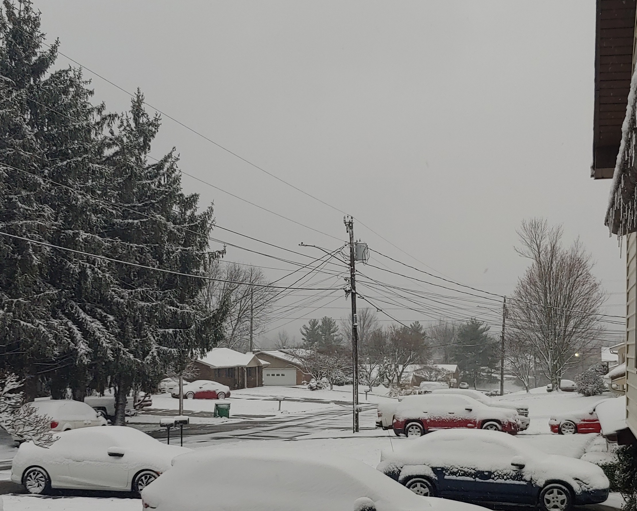
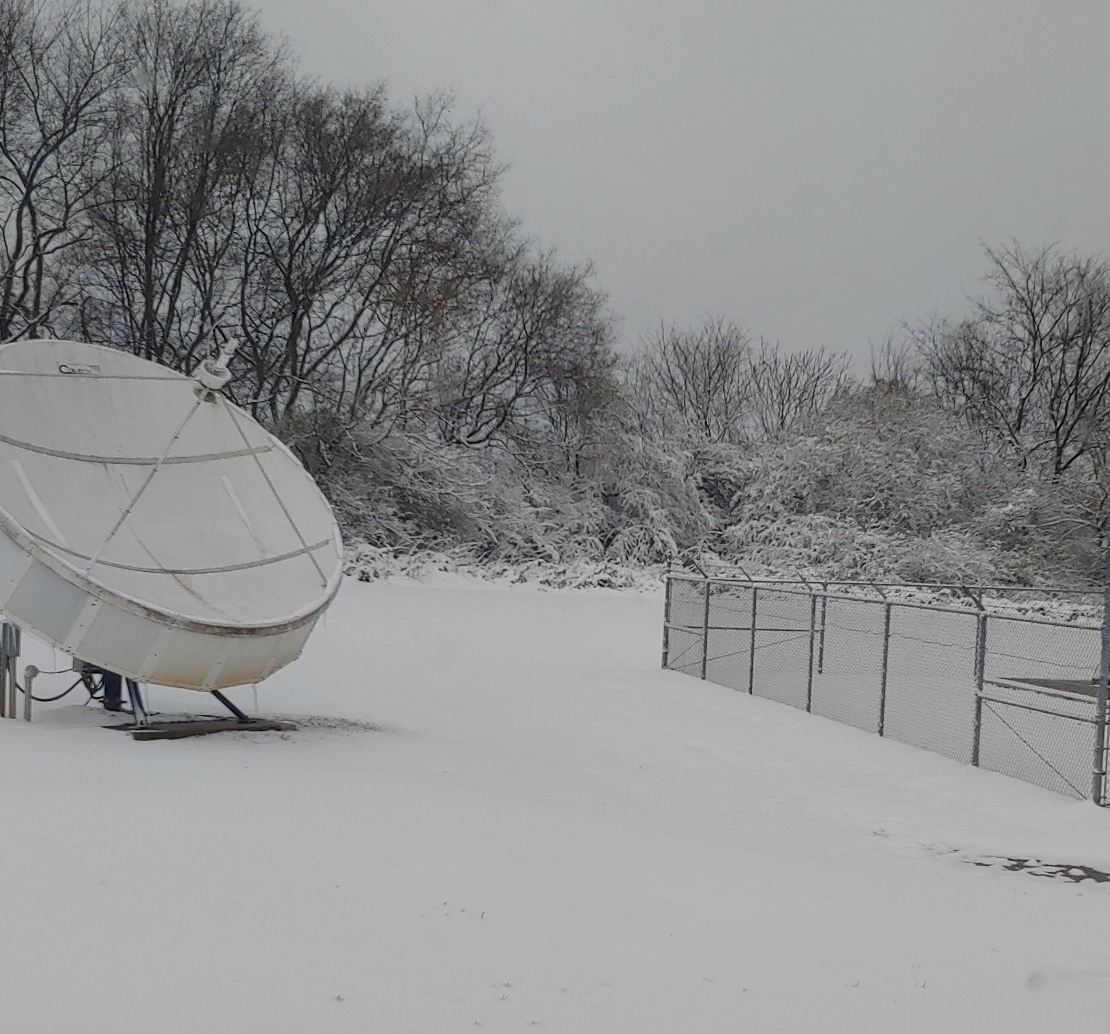
This page provides a meteorological overview of the March 12, 2022 significant snow event that dumped several inches of snow across most of the area, even in the lower elevations. This was a very unusual late-season event and was the most significant widespread March winter event in the region since the '93 Blizzard/Storm of the Century. This event also produced the most single-day snowfall at the Knoxville climate site (6.5") since the 1993 storm as well. The combination of high snowfall rates and strong winds did lead to scattered power outages, in addition to difficult travel. Thundersnow also occurred in portions of the Central and Southern Valley as a result of the very strong lift and sufficient instability.
Radar and Satellite
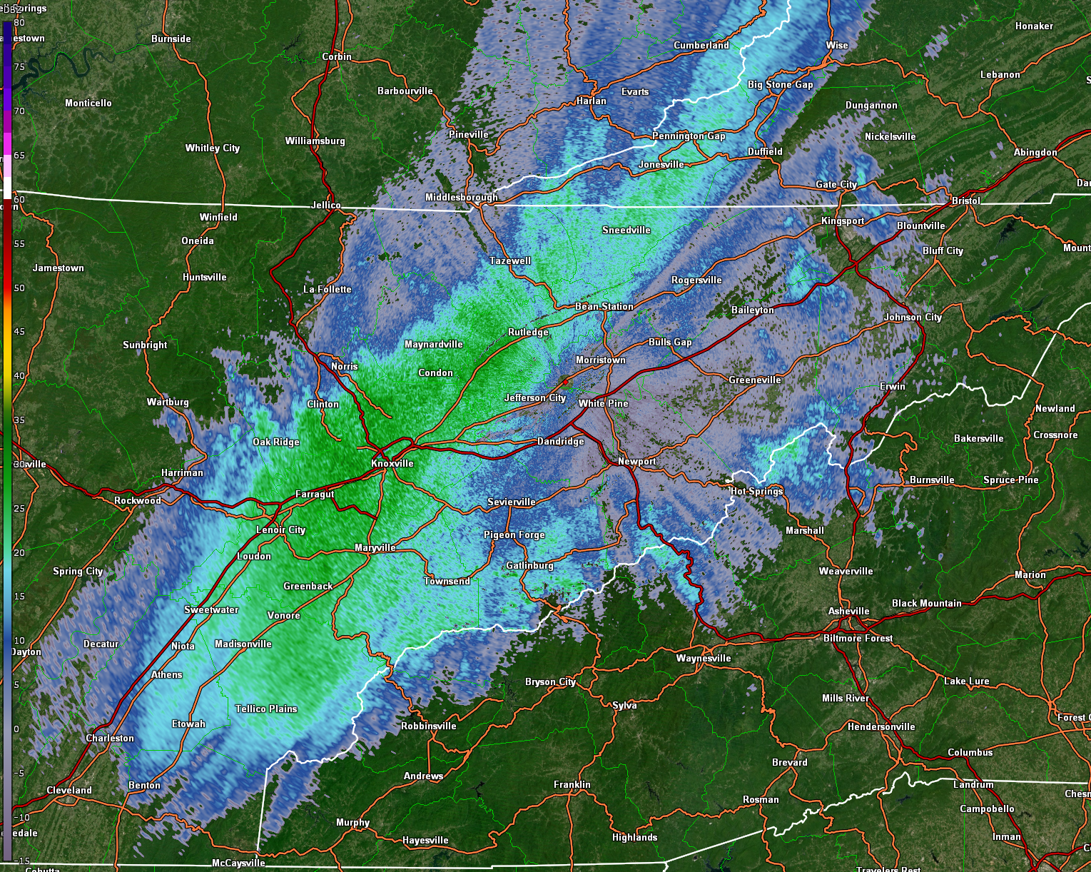
Rain began to transition to sleet and then to snow across the Cumberland Plateau around 1 AM EST. The image on the right (below) shows the Correlation Coefficient product (CC), which can tell us what type of precipitation is falling. The narrow strip of yellow colors along the Plateau indicates a zone of mixed precipitation types, and around this time, there were reports of sleet in that area. To the east of that zone, precipitation was falling as rain, and to the west, it was mainly snow.
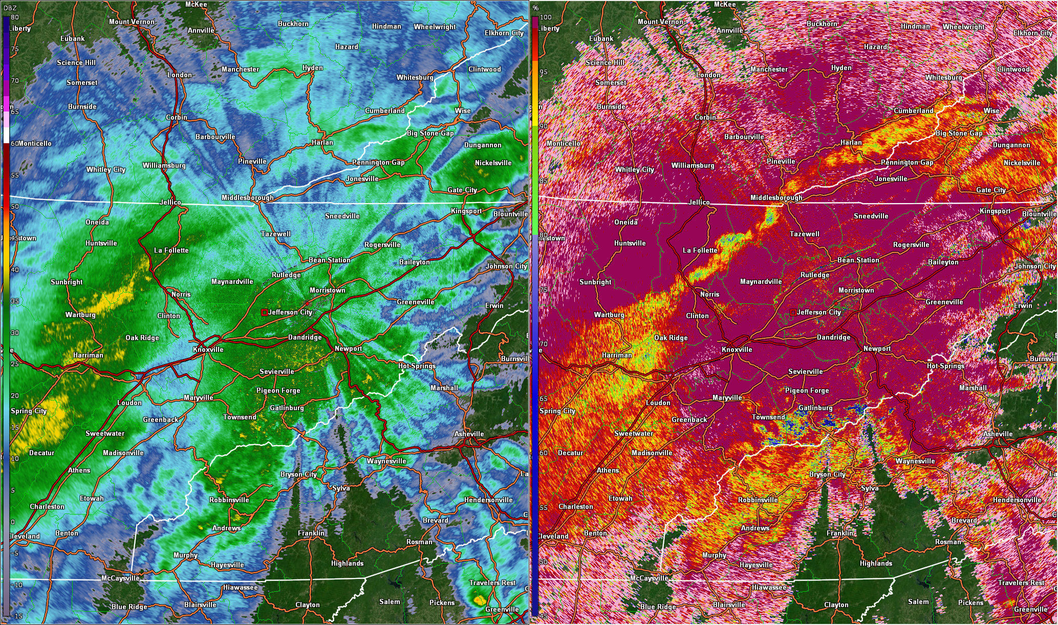 |
| KMRX Radar: Base Reflectivity (left) and Correlation Coefficient (right) at 12:55 AM EST |
Around 1:45 AM EST, an intense cell moved across Roane County and produced several lightning strikes. Thundersnow was reported with this cell.
 |
| KMRX Radar: Base Reflectivity at 1:44 AM EST |
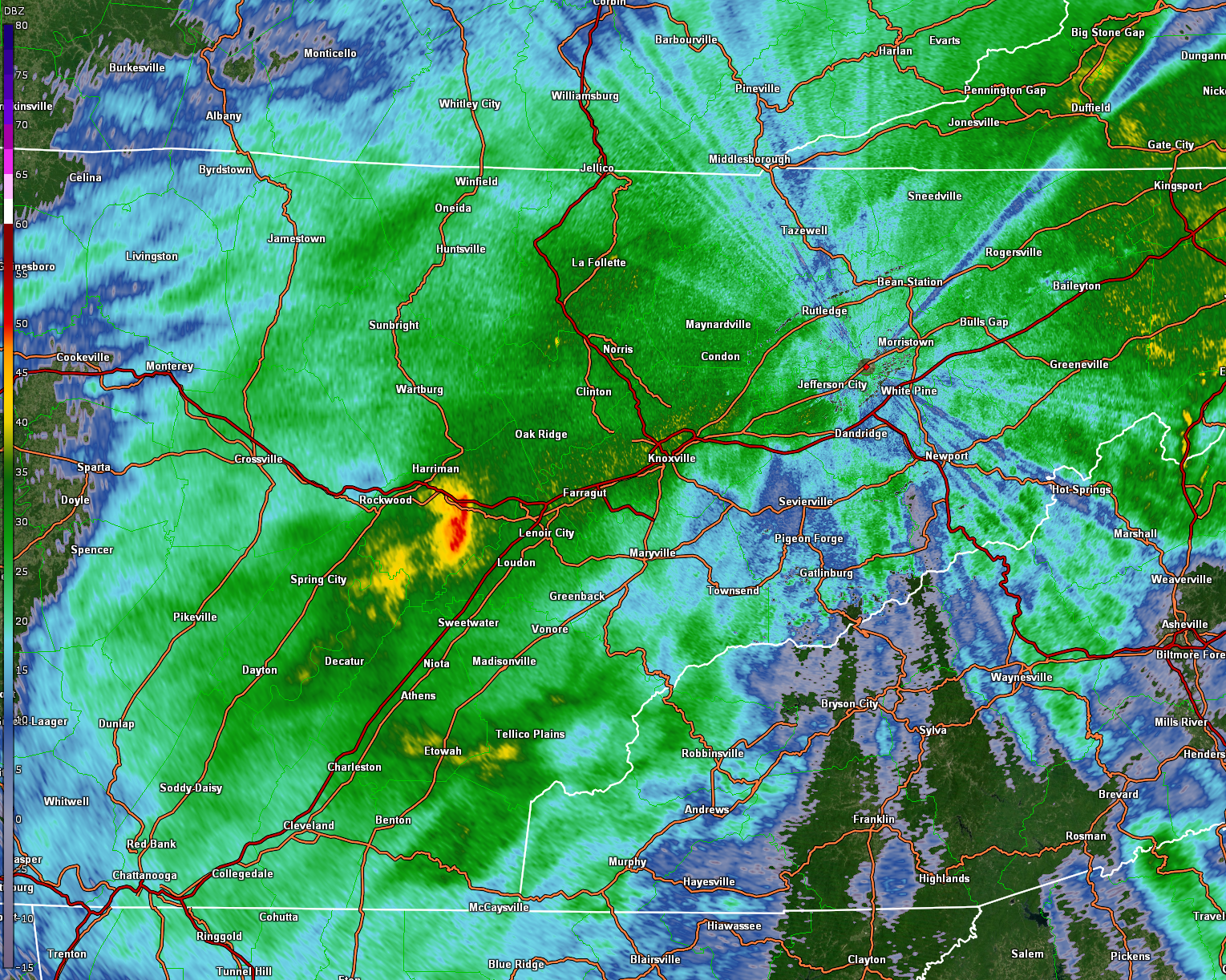
A band of heavy snowfall crossed the Cumberland Plateau around 4:30 AM EST, which resulted in snow accumulations of 7 inches or more in that area.
 |
| KMRX Radar: Base Reflectivity at 4:35 AM EST |
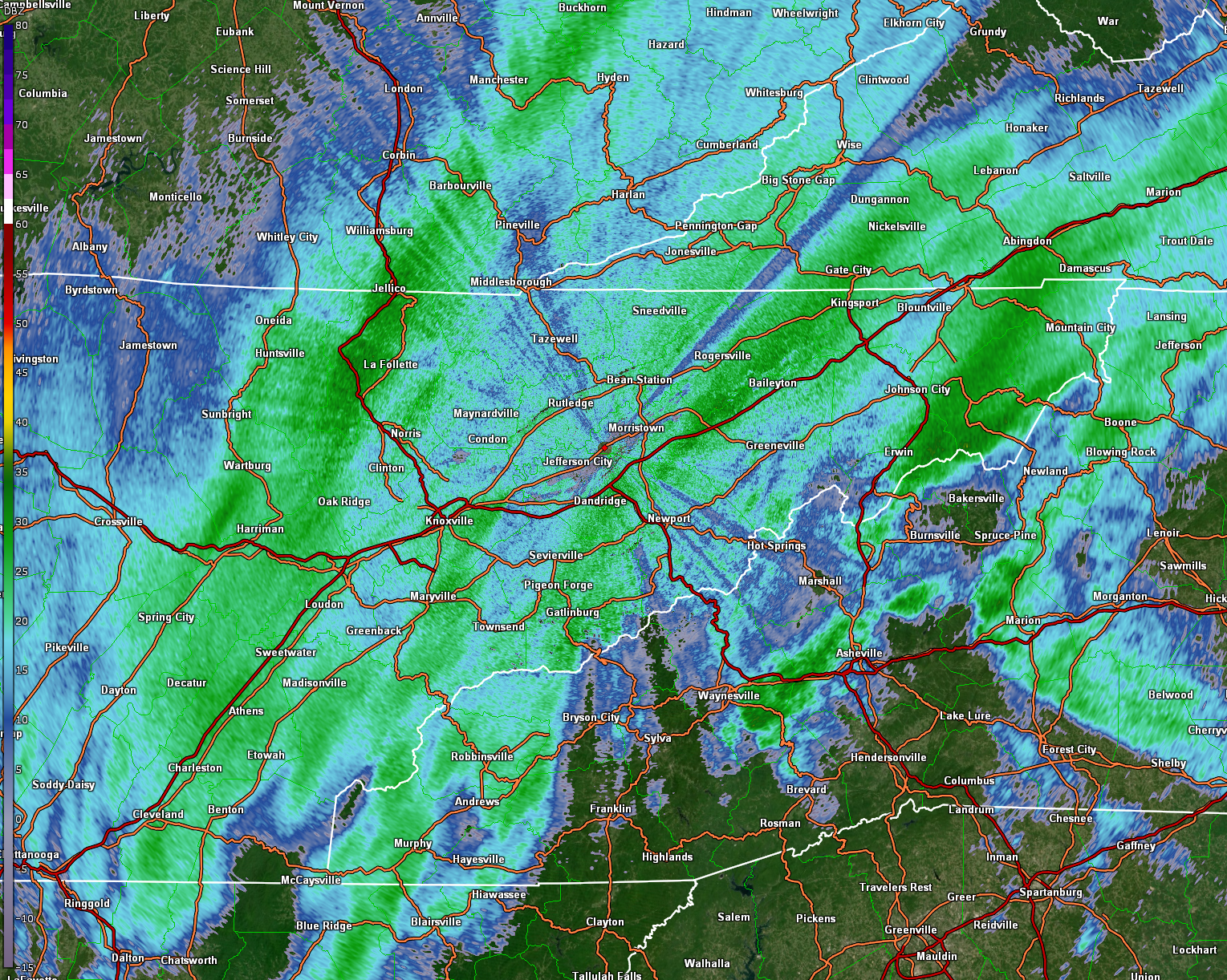
The band of heavy snowfall moved from the Cumberland Plateau into the Knoxville area around 6 AM EST, producing between 4 and 6 inches of snow.
 |
| KMRX Radar: Base Reflectivity at 6:00 AM EST |
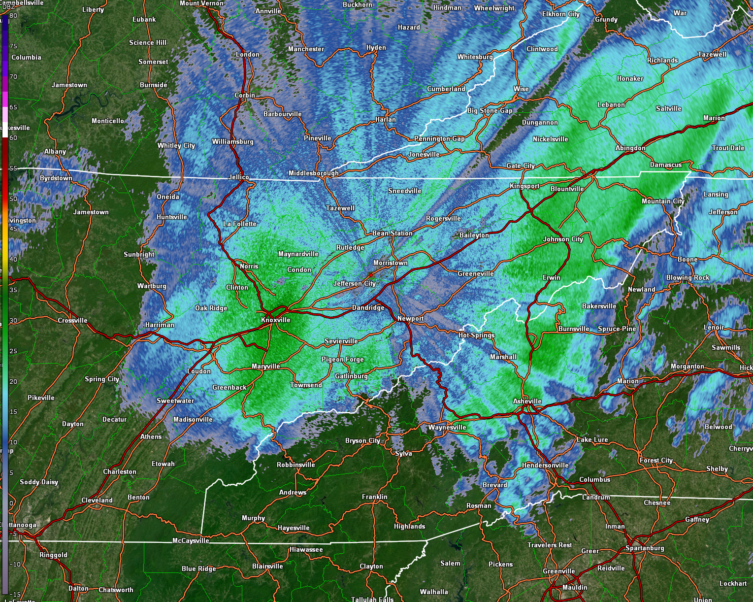
A second band of heavy snowfall moved across Knoxville around 8 AM EST, adding an additional 1-2 inches of snow.
 |
| KMRX Radar: Base Reflectivity at 8:07 AM EST |
The below image is a loop of lightning data during the early morning hours on Saturday. While much of the lightning was associated with convection over towards the Carolinas and Georgia, some strikes can be seen near and west of the Knoxville area about halfway through the loop with banding of heavy snow. This was a result of sufficient instability and very strong lift associated with the system.
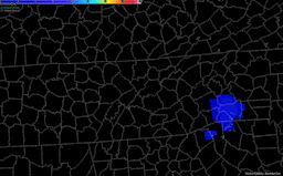 |
| GOES Satellite: Geostationary Lightning Mapper (GLM) Early Saturday Morning |
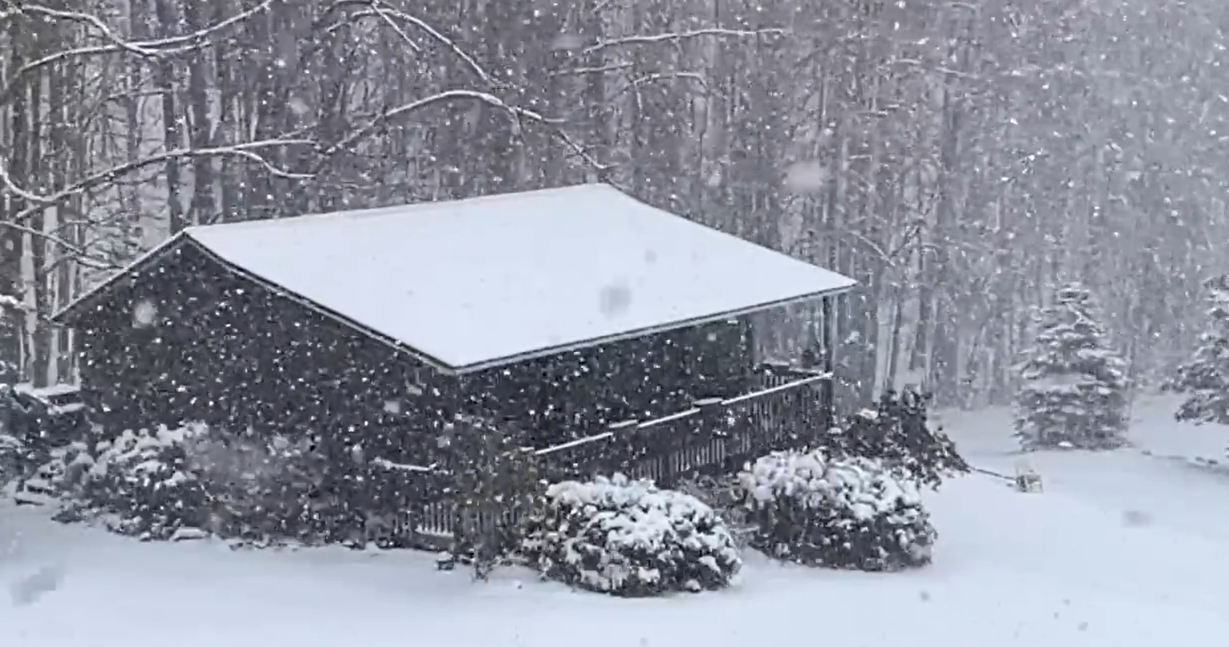
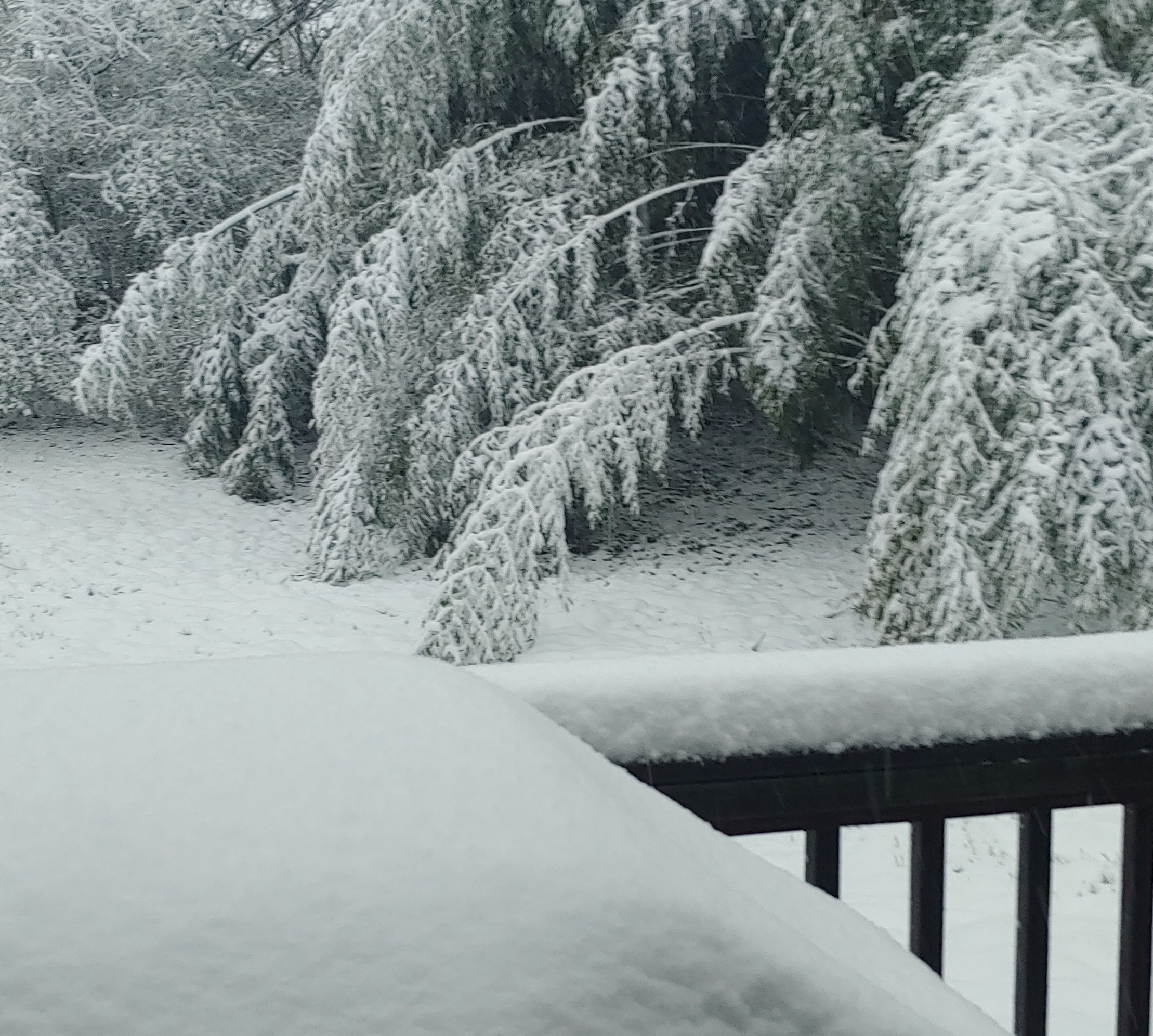
Photos & Video
 |
 |
 |
 |
| Near Roan Mountain (Courtesy Tom Niziol) |
Snow Weighing Down Branches in Morristown, TN (NWS Employee) |
Morristown, TN (NWS Employee) |
Morristown, TN NWS Office (NWS Employee) |
Storm Reports
 |
| Map Containing Received Snowfall Reports and a Spatial Interpolation of Their Values |
..TIME... ...EVENT... ...CITY LOCATION... ...LAT.LON... ..DATE... ....MAG.... ..COUNTY LOCATION..ST.. ...SOURCE.... ..REMARKS.. 0231 PM HEAVY SNOW 1 NE NEWPORT 35.97N 83.18W 03/12/2022 E7.0 INCH COCKE TN PUBLIC 0230 PM HEAVY SNOW 1 E ERWIN 36.15N 82.39W 03/12/2022 E4.0 INCH UNICOI TN PUBLIC 0154 PM SNOW 4 WSW EVANSTON 36.49N 83.35W 03/12/2022 E3.0 INCH HANCOCK TN PUBLIC 0154 PM SNOW 3 W WARTBURG 36.11N 84.63W 03/12/2022 E9.0 INCH MORGAN TN PUBLIC SNOW DRIFTS UP TO THE KNEES. 0123 PM HEAVY SNOW 1 ENE LA FOLLETTE 36.38N 84.11W 03/12/2022 E9.0 INCH CAMPBELL TN PUBLIC 0107 PM HEAVY SNOW 2 ESE CHESTNUT HILL 35.92N 83.31W 03/12/2022 M5.0 INCH JEFFERSON TN PUBLIC UPDATED REPORT FROM THIS MORNING. ELEVATION 1660 FEET. 0100 PM HEAVY SNOW NORRIS 36.21N 84.06W 03/12/2022 E7.0 INCH ANDERSON TN PUBLIC TIME ESTIMATED. FROM SOCIAL MEDIA PICTURE. 0100 PM HEAVY SNOW BIG STONE GAP 36.86N 82.78W 03/12/2022 E5.0 INCH WISE VA PUBLIC TIME ESTIMATED. FROM PICTURE ON SOCIAL MEDIA. ELEVATION 2370 FEET. 0100 PM HEAVY SNOW 4 SW ROAN MOUNTAIN 36.14N 82.13W 03/12/2022 M5.5 INCH CARTER TN PUBLIC RETIRED NWS EMPLOYEE. 1240 PM HEAVY SNOW 2 E HONAKER 37.02N 81.95W 03/12/2022 E6.5 INCH RUSSELL VA PUBLIC ELEVATION 2100 FEET. CURRENT TEMPERATURE 21 DEGREES. 1239 PM SNOW 1 SSW JOHNSON CITY 36.32N 82.37W 03/12/2022 M2.5 INCH WASHINGTON TN TRAINED SPOTTER REPORTED BY TRAINED SPOTTER. 1203 PM SNOW 2 N MOSHEIM 36.22N 82.95W 03/12/2022 M3.5 INCH GREENE TN TRAINED SPOTTER 1203 PM SNOW 2 NNE GRAY 36.44N 82.46W 03/12/2022 M3.0 INCH WASHINGTON TN TRAINED SPOTTER REPORTED BY TRAINED SPOTTER. 1145 AM HEAVY SNOW 1 NE TASSO 35.21N 84.80W 03/12/2022 E4.0 INCH BRADLEY TN PUBLIC TIME ESTIMATED. AT CLEVELAND JET PORT. 1145 AM HEAVY SNOW DECATUR 35.52N 84.79W 03/12/2022 E5.0 INCH MEIGS TN PUBLIC 1145 AM HEAVY SNOW BENTON 35.18N 84.65W 03/12/2022 E4.0 INCH POLK TN PUBLIC TIME ESTIMATED. FROM SOCIAL MEDIA. 1131 AM HEAVY SNOW 1 NNE JACKSBORO 36.35N 84.18W 03/12/2022 E7.0 INCH CAMPBELL TN PUBLIC CORRECTS PREVIOUS SNOW REPORT FROM 1 NNE JACKSBORO. 1115 AM SNOW 1 SSW KINGSPORT 36.52N 82.56W 03/12/2022 M2.5 INCH SULLIVAN TN TRAINED SPOTTER REPORTED BY TRAINED SPOTTER. 1102 AM SNOW 1 WSW ERWIN 36.14N 82.42W 03/12/2022 E2.5 INCH UNICOI TN PUBLIC 1100 AM HEAVY SNOW COSBY 35.81N 83.25W 03/12/2022 M4.5 INCH COCKE TN PUBLIC 1059 AM SNOW 2 SSW SURGOINSVILLE 36.45N 82.88W 03/12/2022 M2.0 INCH HAWKINS TN TRAINED SPOTTER REPORTED BY TRAINED SPOTTER. 1058 AM SNOW 3 SW GREENEVILLE 36.14N 82.86W 03/12/2022 E3.1 INCH GREENE TN PUBLIC 1052 AM SNOW 6 E DUNLAP 35.37N 85.28W 03/12/2022 M3.0 INCH SEQUATCHIE TN TRAINED SPOTTER 1042 AM HEAVY SNOW 2 W FARRAGUT 35.87N 84.21W 03/12/2022 E8.0 INCH KNOX TN PUBLIC FROM PICTURE IN SOCIAL MEDIA. FOX RUN SUBDIVISION. 1040 AM SNOW MILLIGAN COLLEGE 36.27N 82.30W 03/12/2022 E2.8 INCH CARTER TN PUBLIC TIME ESTIMATED. FROM PICTURE IN SOCIAL MEDIA. 1040 AM HEAVY SNOW WISE 36.98N 82.58W 03/12/2022 E7.0 INCH WISE VA PUBLIC TIME ESTIMATED. 2700 FOOT ELEVATION. FROM PICTURE ON SOCIAL MEDIA. 1040 AM HEAVY SNOW WARTBURG 36.10N 84.59W 03/12/2022 M5.3 INCH MORGAN TN TRAINED SPOTTER 1038 AM HEAVY SNOW 3 SSW MARYVILLE 35.71N 84.00W 03/12/2022 E8.0 INCH BLOUNT TN PUBLIC 1022 AM HEAVY SNOW 4 SW BEARDEN 35.90N 84.06W 03/12/2022 M7.2 INCH KNOX TN PUBLIC 1020 AM HEAVY SNOW 3 ESE FAIRVIEW 35.78N 84.53W 03/12/2022 M5.3 INCH ROANE TN PUBLIC 1017 AM HEAVY SNOW 2 W WARTBURG 36.11N 84.63W 03/12/2022 M9.0 INCH MORGAN TN PUBLIC TWO FOOT DRIFTS NEAR HOUSES. 1015 AM HEAVY SNOW 3 S FRIENDSVILLE 35.72N 84.14W 03/12/2022 E5.3 INCH BLOUNT TN PUBLIC 1014 AM HEAVY SNOW 7 SSW JONESVILLE 36.59N 83.15W 03/12/2022 M7.5 INCH LEE VA TRAINED SPOTTER REPORTED BY TRAINED SPOTTER. HIGHER AMOUNTS IN DRIFTS. ELEVATION 1600 FEET. LOCATION 6 NE OF SNEEDVILLE TN. 1005 AM HEAVY SNOW 1 ENE JONESVILLE 36.69N 83.10W 03/12/2022 M5.5 INCH LEE VA TRAINED SPOTTER REPORTED BY TRAINED SPOTTER. 1000 AM SNOW 4 E OLD CUMBERLAND 35.54N 85.30W 03/12/2022 M2.0 INCH BLEDSOE TN COCORAHS COCORAHS STATION TN-BL-2 PIKEVILLE 7.5 SW. 1000 AM SNOW 7 E DUNLAP 35.38N 85.27W 03/12/2022 M2.0 INCH SEQUATCHIE TN COCORAHS COCORAHS STATION TN-SQ-27 GRAYSVILLE 11.6 WSW. 1000 AM SNOW 5 N PARROTTSVILLE 36.09N 83.10W 03/12/2022 E4.0 INCH COCKE TN PUBLIC 0956 AM HEAVY SNOW 3 S POWELL 35.99N 84.02W 03/12/2022 E6.9 INCH KNOX TN PUBLIC 0952 AM HEAVY SNOW 1 WNW CLINTON 36.09N 84.14W 03/12/2022 M7.0 INCH ANDERSON TN PUBLIC 0947 AM HEAVY SNOW 1 E MAYNARDVILLE 36.25N 83.80W 03/12/2022 M6.3 INCH UNION TN COCORAHS COCORAHS STATION TN-UN-3 MAYNARDVILLE 0.6 E. 0945 AM HEAVY SNOW 4 NW FRIENDSVILLE 35.81N 84.18W 03/12/2022 M6.8 INCH LOUDON TN PUBLIC FLURRIES NOW. SNOW HEAVY ON TREES AND POWERLINES. 0936 AM HEAVY SNOW 4 N LAKE FOREST 35.98N 83.86W 03/12/2022 M5.9 INCH KNOX TN PUBLIC 0930 AM SNOW 2 WNW CLEVELAND 35.19N 84.90W 03/12/2022 M3.0 INCH BRADLEY TN AMATEUR RADIO REPORTED BY TRAINED SPOTTER. 0922 AM HEAVY SNOW 1 NNE SHARPS CHAPEL 36.35N 83.80W 03/12/2022 M6.7 INCH UNION TN PUBLIC REPORTED BY TRAINED SPOTTER. 0915 AM SNOW 2 NE RED BANK 35.14N 85.27W 03/12/2022 M1.0 INCH HAMILTON TN BROADCAST MEDIA 0910 AM HEAVY SNOW 1 SW EMORY-MEADOW VIEW 36.76N 81.86W 03/12/2022 E9.0 INCH WASHINGTON VA PUBLIC SNOWING LIGHTLY. 0909 AM SNOW 2 N LA FOLLETTE 36.40N 84.13W 03/12/2022 M10.6 INCH CAMPBELL TN PUBLIC 0908 AM HEAVY SNOW 4 SW BEARDEN 35.90N 84.06W 03/12/2022 E8.4 INCH KNOX TN PUBLIC MEASUREMENT TAKEN AFTER HEAVY SNOW BAND MOVED THROUGH. 0900 AM SNOW 5 NW MCDONALD 35.15N 85.05W 03/12/2022 M2.0 INCH HAMILTON TN COCORAHS COCORAHS STATION TN-HL-14 OOLTEWAH 6.7 NNE. 0900 AM SNOW 1 WSW MONTEAGLE 35.22N 85.84W 03/12/2022 M2.0 INCH MARION TN CO-OP OBSERVER CO-OP OBSERVER STATION MTET1 MONTEAGLE. 0900 AM SNOW 1 WSW ALPHA 36.17N 83.40W 03/12/2022 M3.8 INCH HAMBLEN TN NWS EMPLOYEE MAXIMUM SNOW DEPTH OF 3.8 INCHES MEASURED AT NWS MORRISTOWN OFFICE. 0900 AM HEAVY SNOW 6 SW BEARDEN 35.87N 84.08W 03/12/2022 M6.0 INCH KNOX TN PUBLIC 0900 AM SNOW 3 E WARNE 35.00N 83.84W 03/12/2022 M0.5 INCH CLAY NC PUBLIC 0900 AM HEAVY SNOW 1 SSE KARNS 35.96N 84.11W 03/12/2022 E8.0 INCH KNOX TN PUBLIC 0900 AM SNOW 2 SW MAYNARDVILLE 36.23N 83.82W 03/12/2022 M0.5 INCH UNION TN CO-OP OBSERVER CO-OP OBSERVER STATION MAYT1 MAYNARDVILLE 2 SW. 0900 AM SNOW VONORE 35.59N 84.24W 03/12/2022 M3.0 INCH MONROE TN PUBLIC 0855 AM SNOW CHARLESTON 35.29N 84.76W 03/12/2022 M3.0 INCH BRADLEY TN TRAINED SPOTTER 0845 AM HEAVY SNOW 3 WSW ROSE HILL 36.68N 83.35W 03/12/2022 M5.0 INCH LEE VA PUBLIC SOCIAL MEDIA PHOTO OF MEASUREMENT. 0844 AM HEAVY SNOW 1 WNW JELLICO 36.58N 84.15W 03/12/2022 E8.0 INCH CAMPBELL TN PUBLIC 0835 AM SNOW 3 ENE FALL BRANCH 36.43N 82.58W 03/12/2022 E3.5 INCH SULLIVAN TN PUBLIC 0833 AM SNOW 3 N FARRAGUT 35.92N 84.18W 03/12/2022 M7.0 INCH KNOX TN TRAINED SPOTTER REPORTED BY TRAINED SPOTTER. 0832 AM HEAVY SNOW 3 ENE LENOIR CITY 35.82N 84.22W 03/12/2022 M6.3 INCH LOUDON TN TRAINED SPOTTER REPORTED BY TRAINED SPOTTER. 0831 AM SNOW 3 SW HARRISON 35.10N 85.18W 03/12/2022 M2.0 INCH HAMILTON TN COCORAHS COCORAHS STATION TN-HL-31 CHATTANOOGA 5.1 ENE. 0830 AM HEAVY SNOW 1 WSW BEARDEN 35.92N 84.02W 03/12/2022 M6.0 INCH KNOX TN TRAINED SPOTTER REPORTED BY TRAINED SPOTTER. 0830 AM SNOW 7 W OKOLONA 36.57N 82.90W 03/12/2022 E3.4 INCH HANCOCK TN PUBLIC SNOW STILL FALLING NOW. 0830 AM HEAVY SNOW 1 WSW BEARDEN 35.92N 84.02W 03/12/2022 M6.0 INCH KNOX TN COCORAHS COCORAHS STATION TN-KX-62 KNOXVILLE 5.5 SW. 0828 AM HEAVY SNOW 1 SW CLINTON 36.08N 84.14W 03/12/2022 M5.3 INCH ANDERSON TN TRAINED SPOTTER REPORTED BY TRAINED SPOTTER. 0825 AM SNOW 5 SSE MOSHEIM 36.12N 82.94W 03/12/2022 E3.2 INCH GREENE TN PUBLIC LOCATION 6.7 MILES SOUTHWEST OF GREENVILLE NEAR TIMBER RIDGE. 0822 AM HEAVY SNOW 5 NE MURRAY STORE 35.66N 84.57W 03/12/2022 E7.5 INCH ROANE TN PUBLIC 0821 AM HEAVY SNOW 1 NNW MALONEYVILLE 36.10N 83.84W 03/12/2022 E5.0 INCH KNOX TN PUBLIC 0815 AM SNOW 1 SSW COLLEGEDALE 35.02N 85.06W 03/12/2022 M1.8 INCH HAMILTON TN COCORAHS COCORAHS STATION TN-HL-60 OOLTEWAH 3.3 SE. 0814 AM HEAVY SNOW 5 E PHILADELPHIA 35.67N 84.31W 03/12/2022 E5.5 INCH LOUDON TN PUBLIC CURRENTLY SNOWING AND WINDY. 0808 AM HEAVY SNOW KYLES FORD 36.57N 83.04W 03/12/2022 M6.0 INCH HANCOCK TN PUBLIC SOCIAL MEDIA PHOTO OF MEASUREMENT. 0807 AM HEAVY SNOW 3 WNW HOWARD QUARTER 36.49N 83.47W 03/12/2022 M7.5 INCH CLAIBORNE TN EMERGENCY MNGR 0806 AM HEAVY SNOW 5 S MALONEYVILLE 36.01N 83.84W 03/12/2022 M4.5 INCH KNOX TN TRAINED SPOTTER REPORTED BY TRAINED SPOTTER. 0805 AM HEAVY SNOW HALLS 36.09N 83.93W 03/12/2022 M6.5 INCH KNOX TN PUBLIC SOCIAL MEDIA REPORT OF 6.5 INCHES OF SNOW IN HALLS NEAR INTERSECTION OF EMORY RD AND MAYNARDVILLE PIKE. 0805 AM SNOW AFTON 36.19N 82.74W 03/12/2022 E2.0 INCH GREENE TN PUBLIC RELAYED FROM SOCIAL MEDIA. 0803 AM SNOW 4 NW FRIENDSVILLE 35.80N 84.17W 03/12/2022 M3.0 INCH BLOUNT TN COCORAHS COCORAHS STATION TN-BT-9 FRIENDSVILLE 3.6 NW. 0800 AM SNOW 3 E OLD CUMBERLAND 35.55N 85.33W 03/12/2022 M2.0 INCH BLEDSOE TN COCORAHS COCORAHS STATION TN-BL-21 2 E OLD CUMBERLAND. 0800 AM HEAVY SNOW 3 WNW TALBOTT 36.16N 83.46W 03/12/2022 M2.5 INCH HAMBLEN TN NWS EMPLOYEE NWS EMPLOYEE MEASURED 2.5 INCHES OF SNOW AT 8 AM EST. LIQUID EQUIVALENT WAS 0.35 INCHES. 0800 AM HEAVY SNOW 6 NE OAK RIDGE 36.02N 84.22W 03/12/2022 M7.0 INCH ANDERSON TN COCORAHS COCORAHS STATION TN-AN-3 OAK RIDGE 5.7 NE. 0800 AM SNOW 4 SE FORT BLACKMORE 36.72N 82.54W 03/12/2022 M4.0 INCH SCOTT VA COCORAHS COCORAHS STATION VA-SC-1 GATE CITY 6.2 NNE. 0800 AM SNOW 2 ENE CADES COVE 35.60N 83.78W 03/12/2022 M1.5 INCH BLOUNT TN CO-OP OBSERVER CO-OP OBSERVER STATION TNST1 TOWNSEND 5 S. 0800 AM SNOW 3 WNW TALBOTT 36.16N 83.46W 03/12/2022 M2.5 INCH HAMBLEN TN COCORAHS COCORAHS STATION TN-HB-3 JEFFERSON CITY 2.1 NE. 0800 AM SNOW 2 E HAYESVILLE 35.05N 83.79W 03/12/2022 M0.0 INCH CLAY NC COCORAHS COCORAHS STATION NC-CY-5 HAYESVILLE 1.6 E. 0800 AM SNOW 2 NE MURPHY 35.11N 84.01W 03/12/2022 M1.0 INCH CHEROKEE NC CO-OP OBSERVER CO-OP OBSERVER STATION MURN7 MURPHY. 0800 AM SNOW 2 SW ROAN MOUNTAIN 36.16N 82.10W 03/12/2022 M0.5 INCH CARTER TN CO-OP OBSERVER CO-OP OBSERVER STATION RNMT1 ROAN MOUNTAIN. 0800 AM SNOW 2 NE WHITE PINE 36.12N 83.27W 03/12/2022 M3.0 INCH JEFFERSON TN COCORAHS COCORAHS STATION TN-JF-4 WHITE PINE 2.0 NE. 0759 AM HEAVY SNOW ARTHUR 36.55N 83.67W 03/12/2022 M10.0 INCH CLAIBORNE TN PUBLIC SOCIAL MEDIA PHOTO OF MEASUREMENT, PRESUMABLY IN THE GRASS. 0750 AM HEAVY SNOW 4 N FARRAGUT 35.93N 84.19W 03/12/2022 M5.6 INCH KNOX TN PUBLIC REPORT FROM SOCIAL MEDIA. MEASURED 5.6 INCHES IN HARDIN VALLEY. 0750 AM HEAVY SNOW 4 N ALPHA 36.23N 83.39W 03/12/2022 M2.8 INCH HAMBLEN TN NWS EMPLOYEE NWS EMPLOYEE MEASURED 2.8 INCHES OF SNOW. 0748 AM HEAVY SNOW 2 ESE FARRAGUT 35.86N 84.15W 03/12/2022 M4.8 INCH KNOX TN COCORAHS COCORAHS STATION TN-KX-63 FARRAGUT 2.0 ESE. 0742 AM HEAVY SNOW 4 SSE KARNS 35.92N 84.09W 03/12/2022 M6.0 INCH KNOX TN PUBLIC SOCIAL MEDIA PHOTO OF THE MEASUREMENT. 0741 AM HEAVY SNOW 3 SW ATHENS 35.42N 84.65W 03/12/2022 E5.0 INCH MCMINN TN PUBLIC 0739 AM HEAVY SNOW 4 N FARRAGUT 35.93N 84.17W 03/12/2022 E5.5 INCH KNOX TN PUBLIC 0739 AM SNOW 2 NNW CLINTON 36.11N 84.14W 03/12/2022 E3.3 INCH ANDERSON TN PUBLIC 0738 AM HEAVY SNOW HALLS 36.08N 83.93W 03/12/2022 M6.0 INCH KNOX TN PUBLIC SOCIAL MEDIA PHOTO OF THE MEASUREMENT. 0737 AM SNOW 2 SSW COLLEGEDALE 35.02N 85.06W 03/12/2022 M1.8 INCH HAMILTON TN COCORAHS REPORTED BY TRAINED SPOTTER. 0736 AM HEAVY SNOW 2 NE BEARDEN 35.96N 83.98W 03/12/2022 E5.0 INCH KNOX TN PUBLIC 0735 AM SNOW 4 ENE KNOXVILLE 36.00N 83.89W 03/12/2022 E6.0 INCH KNOX TN PUBLIC PHOTO REPORT ON SOCIAL MEDIA. 0735 AM SNOW PETROS 36.09N 84.45W 03/12/2022 E2.0 INCH MORGAN TN PUBLIC SOCIAL MEDIA REPORT OF 2" IN PETROS. 0735 AM SNOW 3 NNW EAST BRAINERD 35.05N 85.13W 03/12/2022 M1.5 INCH HAMILTON TN TRAINED SPOTTER REPORTED BY TRAINED SPOTTER. 0733 AM SNOW 2 SE KNOXVILLE 35.95N 83.92W 03/12/2022 E5.5 INCH KNOX TN PUBLIC PHOTO REPORT ON SOCIAL MEDIA. 0733 AM HEAVY SNOW 3 ESE KARNS 35.96N 84.06W 03/12/2022 E6.5 INCH KNOX TN PUBLIC 0731 AM SNOW PETROS 36.09N 84.44W 03/12/2022 M2.0 INCH MORGAN TN COCORAHS COCORAHS STATION TN-MG-3 PETROS. 0730 AM SNOW 3 ESE CLEVELAND 35.16N 84.82W 03/12/2022 M2.0 INCH BRADLEY TN COCORAHS COCORAHS STATION TN-BR-4 CLEVELAND 3.0 ESE. 0730 AM SNOW 4 ESE CHATTANOOGA 35.04N 85.20W 03/12/2022 E1.0 INCH HAMILTON TN OFFICIAL NWS OBS 0730 AM HEAVY SNOW 3 NW BEARDEN 35.96N 84.05W 03/12/2022 M4.3 INCH KNOX TN TRAINED SPOTTER FROM A TRAINED SPOTTER. 0730 AM HEAVY SNOW SEYMOUR 35.87N 83.77W 03/12/2022 M4.0 INCH SEVIER TN PUBLIC 0730 AM SNOW 1 SSE COLONIAL HEIGHTS 36.47N 82.51W 03/12/2022 M2.6 INCH SULLIVAN TN COCORAHS COCORAHS STATION TN-SL-24 COLONIAL HEIGHTS 0.6 SSE. 0730 AM SNOW 2 NNW KIMBERLIN HEIGHTS 35.96N 83.77W 03/12/2022 M2.7 INCH KNOX TN COCORAHS COCORAHS STATION TN-KX-58 SEYMOUR 5.8 N. 0728 AM HEAVY SNOW SWEETWATER 35.60N 84.47W 03/12/2022 M6.0 INCH MONROE TN PUBLIC SOCIAL MEDIA PHOTO OF MEASUREMENT. 0726 AM SNOW 2 E FARRAGUT 35.87N 84.15W 03/12/2022 E6.0 INCH KNOX TN PUBLIC 0725 AM SNOW 3 E MARYVILLE 35.74N 83.91W 03/12/2022 M2.5 INCH BLOUNT TN PUBLIC 0725 AM SNOW 1 WSW RUTLEDGE 36.27N 83.55W 03/12/2022 M4.0 INCH GRAINGER TN PUBLIC 0725 AM SNOW TRI-CITY AIRPORT 36.48N 82.41W 03/12/2022 E2.0 INCH SULLIVAN TN OFFICIAL NWS OBS 0725 AM SNOW 1 NNE EAST BRAINERD 35.03N 85.10W 03/12/2022 M1.8 INCH HAMILTON TN TRAINED SPOTTER REPORTED BY TRAINED SPOTTER. 0725 AM SNOW 3 ESE WARTBURG 36.09N 84.54W 03/12/2022 E3.0 INCH MORGAN TN PUBLIC WINDY CONDITIONS, BLOWING SNOW. 0725 AM HEAVY SNOW LENOIR CITY 35.80N 84.27W 03/12/2022 M6.8 INCH LOUDON TN PUBLIC SOCIAL MEDIA PHOTO OF MEASUREMENT. 0724 AM HEAVY SNOW 1 NNW JONESVILLE 36.71N 83.13W 03/12/2022 M4.5 INCH LEE VA TRAINED SPOTTER REPORTED BY TRAINED SPOTTER. 0723 AM SNOW 5 WNW EVANSTON 36.54N 83.37W 03/12/2022 E4.5 INCH HANCOCK TN PUBLIC 0723 AM SNOW 2 SW DRYDEN 36.75N 82.98W 03/12/2022 E5.0 INCH LEE VA LAW ENFORCEMENT 0722 AM SNOW 2 N NORTON 36.97N 82.63W 03/12/2022 E6.0 INCH WISE VA LAW ENFORCEMENT 0721 AM HEAVY SNOW FRIENDSVILLE 35.76N 84.13W 03/12/2022 M3.5 INCH BLOUNT TN PUBLIC SOCIAL MEDIA PHOTO OF MEASUREMENT. 0721 AM SNOW DAYTON 35.49N 85.01W 03/12/2022 M2.8 INCH RHEA TN PUBLIC SOCIAL MEDIA PHOTO OF MEASUREMENT. 0720 AM SNOW 3 SSE STRAWBERRY PLAINS 36.02N 83.67W 03/12/2022 M3.5 INCH SEVIER TN NWS EMPLOYEE CORRECTS REPORT SOURCE OF PREVIOUS SNOW REPORT FROM 3 SSE STRAWBERRY PLAINS. 0718 AM SNOW 2 ESE CHESTNUT HILL 35.92N 83.31W 03/12/2022 M3.0 INCH JEFFERSON TN PUBLIC 0715 AM SNOW FRIENDSVILLE 35.76N 84.13W 03/12/2022 E3.5 INCH BLOUNT TN PUBLIC PHOTO REPORT ON SOCIAL MEDIA. 0715 AM SNOW MADISONVILLE 35.52N 84.36W 03/12/2022 E5.0 INCH MONROE TN PUBLIC PHOTO REPORT ON SOCIAL MEDIA. 0715 AM SNOW JONESVILLE 36.69N 83.12W 03/12/2022 M7.0 INCH LEE VA PUBLIC 0712 AM SNOW 1 SSW DUNLAP 35.36N 85.39W 03/12/2022 E2.0 INCH SEQUATCHIE TN PUBLIC 0710 AM SNOW 2 NE ELGIN 36.35N 84.59W 03/12/2022 E7.0 INCH SCOTT TN PUBLIC SOCIAL MEDIA REPORT. 0709 AM SNOW 3 W CLOVER HILL 35.70N 84.12W 03/12/2022 M3.0 INCH BLOUNT TN PUBLIC 0703 AM SNOW 5 ENE CULBERSON 35.01N 84.09W 03/12/2022 M0.2 INCH CHEROKEE NC COCORAHS COCORAHS STATION NC-CK-14 3 N NOTTELY DAM. 0700 AM SNOW 2 E KINGSPORT 36.53N 82.51W 03/12/2022 E2.8 INCH SULLIVAN TN PUBLIC 0700 AM SNOW 2 S OOLTEWAH 35.04N 85.09W 03/12/2022 M2.5 INCH HAMILTON TN COCORAHS COCORAHS STATION TN-HL-23 OOLTEWAH 3.0 SW. 0700 AM HEAVY SNOW 2 WSW MORRISTOWN 36.21N 83.33W 03/12/2022 M4.0 INCH HAMBLEN TN CO-OP OBSERVER CO-OP OBSERVER STATION MRIT1 MORRISTOWN. 0700 AM SNOW KINGSTON 35.87N 84.51W 03/12/2022 E6.0 INCH ROANE TN PUBLIC PHOTO REPORT VIA SOCIAL MEDIA. 0700 AM SNOW SHARPS CHAPEL 36.35N 83.80W 03/12/2022 E6.0 INCH UNION TN PUBLIC 0700 AM HEAVY SNOW 3 WNW TEN MILE 35.68N 84.71W 03/12/2022 M6.0 INCH MEIGS TN COCORAHS COCORAHS STATION TN-MS-1 TEN MILE 2.2 NW. 0700 AM HEAVY SNOW 3 WSW JONESVILLE 36.67N 83.17W 03/12/2022 M6.5 INCH LEE VA COCORAHS COCORAHS STATION VA-LE-2 JONESVILLE 3.1 WSW. 0700 AM HEAVY SNOW 3 ENE POWELL 36.05N 83.99W 03/12/2022 M6.0 INCH KNOX TN COCORAHS COCORAHS STATION TN-KX-34 KNOXVILLE 5.7 NNW. 0700 AM HEAVY SNOW 3 ENE FARRAGUT 35.89N 84.14W 03/12/2022 M6.0 INCH KNOX TN COCORAHS COCORAHS STATION TN-KX-23 FARRAGUT 2.8 ENE. 0700 AM HEAVY SNOW 1 SW NORRIS 36.20N 84.08W 03/12/2022 M6.8 INCH ANDERSON TN COCORAHS COCORAHS STATION TN-AN-8 NORRIS 0.6 NW. 0700 AM SNOW 3 SSW JONESBOROUGH 36.26N 82.50W 03/12/2022 M2.8 INCH WASHINGTON TN COCORAHS COCORAHS STATION TN-WS-22 JONESBOROUGH 2.7 SSW. 0700 AM SNOW 3 SSW JONESBOROUGH 36.26N 82.50W 03/12/2022 M2.1 INCH WASHINGTON TN COCORAHS COCORAHS STATION TN-WS-12 2 SSW JONESBOROUGH. 0700 AM SNOW 1 WNW PARKSVILLE 35.10N 84.67W 03/12/2022 M3.0 INCH POLK TN COCORAHS COCORAHS STATION TN-PK-2 OCOEE 3.3 ESE. 0700 AM SNOW 2 N JASPER 35.08N 85.63W 03/12/2022 M0.4 INCH MARION TN COCORAHS COCORAHS STATION TN-MA-3 JASPER 1.7 N. 0700 AM SNOW 2 ESE HARRISON 35.12N 85.12W 03/12/2022 M2.5 INCH HAMILTON TN COCORAHS COCORAHS STATION TN-HL-19 1 E HARRISON. 0700 AM SNOW 3 SSE CLOVER HILL 35.67N 84.04W 03/12/2022 M2.5 INCH BLOUNT TN COCORAHS COCORAHS STATION TN-BT-39 MARYVILLE 6.7 SW. 0700 AM SNOW 3 ESE MARYVILLE 35.74N 83.91W 03/12/2022 M2.5 INCH BLOUNT TN COCORAHS COCORAHS STATION TN-BT-29 MARYVILLE 3.4 ESE. 0700 AM SNOW 3 W WALLAND 35.73N 83.87W 03/12/2022 M2.0 INCH BLOUNT TN COCORAHS COCORAHS STATION TN-BT-26 MARYVILLE 5.8 ESE. 0700 AM SNOW 1 W CLEVELAND 35.18N 84.89W 03/12/2022 M3.5 INCH BRADLEY TN COCORAHS COCORAHS STATION TN-BR-24 CLEVELAND 1.2 W. 0700 AM SNOW 1 NW ELIZABETHTON 36.35N 82.25W 03/12/2022 M2.6 INCH CARTER TN CO-OP OBSERVER CO-OP OBSERVER STATION ELZT1 ELIZABETHTON. 0700 AM HEAVY SNOW 2 SSW KINGSTON 35.85N 84.53W 03/12/2022 M6.0 INCH ROANE TN COCORAHS COCORAHS STATION TN-KX-56 KINGSTON 1.9 SSW. 0700 AM HEAVY SNOW 1 NE LEBANON 36.91N 82.07W 03/12/2022 M4.0 INCH RUSSELL VA CO-OP OBSERVER CO-OP OBSERVER STATION LBOV2 LEBANON. 0700 AM SNOW 5 SSE TRI-CITY AIRPORT 36.41N 82.38W 03/12/2022 M1.8 INCH SULLIVAN TN COCORAHS COCORAHS STATION TN-SL-1 4 SSE TRI-CITY AIRPORT. 0655 AM SNOW 3 SW BEARDEN 35.90N 84.04W 03/12/2022 M5.0 INCH KNOX TN PUBLIC 0652 AM SNOW 1 WNW CLINTON 36.09N 84.14W 03/12/2022 M4.5 INCH ANDERSON TN PUBLIC 0650 AM SNOW 3 ESE KARNS 35.96N 84.06W 03/12/2022 E5.0 INCH KNOX TN PUBLIC REPORT FROM SOCIAL MEDIA. 0646 AM HEAVY SNOW 2 N FARRAGUT 35.91N 84.18W 03/12/2022 M6.2 INCH KNOX TN PUBLIC SOCIAL MEDIA REPORT OF 6.2 INCHES OF SNOW JUST NORTH OF CAMPBELL STATION RD EXIT ON I-40. 0646 AM HEAVY SNOW 2 N FARRAGUT 35.91N 84.18W 03/12/2022 E6.3 INCH KNOX TN PUBLIC SNOW IS BLOWING AND DRIFTING. 0640 AM SNOW 1 NNE DAYTON 35.50N 85.01W 03/12/2022 E2.7 INCH RHEA TN PUBLIC REPORT VIA SOCIAL MEDIA. 0639 AM SNOW 4 NNE ELGIN 36.39N 84.57W 03/12/2022 M7.0 INCH SCOTT TN PUBLIC 0630 AM SNOW 4 NNE OAK RIDGE 36.01N 84.26W 03/12/2022 E5.7 INCH ANDERSON TN PUBLIC PHOTO REPORT ON SOCIAL MEDIA. 0630 AM SNOW 1 SSE CARYVILLE 36.31N 84.21W 03/12/2022 E8.0 INCH CAMPBELL TN PUBLIC REPORTS VIA SOCIAL MEDIA PICTURES. 0629 AM SNOW 4 SW BEARDEN 35.90N 84.06W 03/12/2022 M6.1 INCH KNOX TN PUBLIC 0610 AM SNOW 1 N KNOXVILLE 35.99N 83.95W 03/12/2022 E4.5 INCH KNOX TN BROADCAST MEDIA 0607 AM SNOW 3 WSW BEARDEN 35.91N 84.04W 03/12/2022 E4.0 INCH KNOX TN PUBLIC 0600 AM HEAVY SNOW 2 NW TASSO 35.22N 84.83W 03/12/2022 E4.0 INCH BRADLEY TN PUBLIC 0600 AM SNOW 4 SSW LUTTRELL 36.15N 83.78W 03/12/2022 E4.5 INCH KNOX TN PUBLIC REPORT VIA SOCIAL MEDIA. 0600 AM HEAVY SNOW 1 N KYLES FORD 36.59N 83.04W 03/12/2022 M5.4 INCH HANCOCK TN COCORAHS COCORAHS STATION TN-HC-2 KYLES FORD 1.0 N. 0600 AM SNOW 6 SSE GATLINBURG 35.66N 83.44W 03/12/2022 M3.0 INCH SEVIER TN CO-OP OBSERVER CO-OP OBSERVER STATION MTLT1 GATLINBURG 5 SE. 0600 AM SNOW 3 SW GATLINBURG 35.69N 83.54W 03/12/2022 M1.6 INCH SEVIER TN CO-OP OBSERVER CO-OP OBSERVER STATION GTLT1 GATLINBURG 2 SW. 0600 AM SNOW 3 S ABINGDON 36.67N 81.97W 03/12/2022 M1.5 INCH WASHINGTON VA CO-OP OBSERVER CO-OP OBSERVER STATION ABIV2 ABINGDON 3S. 0556 AM SNOW 2 WSW BRISTOL VA 36.61N 82.21W 03/12/2022 E2.0 INCH CITY OF BRISTOL VA PUBLIC 0555 AM SNOW 1 WSW ALPHA 36.17N 83.40W 03/12/2022 M2.8 INCH HAMBLEN TN PUBLIC 0549 AM SNOW 7 NW SODDY-DAISY 35.35N 85.25W 03/12/2022 E4.0 INCH SEQUATCHIE TN PUBLIC 0548 AM SNOW 2 SW SEVIERVILLE 35.86N 83.60W 03/12/2022 E1.5 INCH SEVIER TN PUBLIC 0546 AM SNOW 4 NNE PAINT ROCK 35.80N 84.50W 03/12/2022 E4.5 INCH ROANE TN PUBLIC 0545 AM SNOW 2 WNW KNOXVILLE 35.98N 83.98W 03/12/2022 E5.0 INCH KNOX TN PUBLIC 0541 AM SNOW 2 N KNOXVILLE 36.01N 83.95W 03/12/2022 E4.5 INCH KNOX TN PUBLIC 0530 AM SNOW 1 SSW BULLS GAP 36.25N 83.09W 03/12/2022 M2.0 INCH HAWKINS TN COCORAHS COCORAHS STATION TN-HK-8 BULLS GAP 0.9 SSW. 0500 AM SNOW ROAN MOUNTAIN 36.18N 82.07W 03/12/2022 E2.0 INCH CARTER TN PUBLIC 0500 AM SNOW 1 N LA FOLLETTE 36.39N 84.13W 03/12/2022 E7.0 INCH CAMPBELL TN PUBLIC REPORTED VIA SOCIAL MEDIA.
Environment
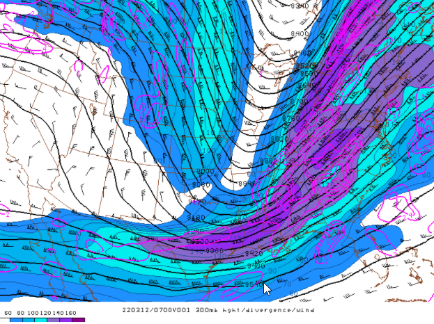
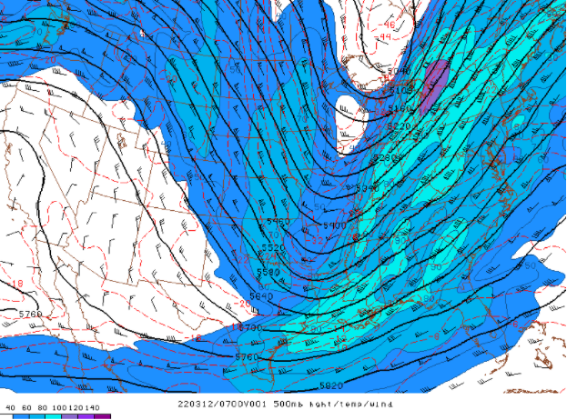
A strong upper trough moved across the midsection of the nation into the Ohio and Tennessee Valleys from Friday night into Saturday morning. The strongest part of the jet was over the eastern Great Lakes where 300mb winds exceeded 160 knots. Another jet moved across the Gulf Coast states into the southern Appalachians. The two jets produced a double-jet configuration across the Tennessee Valley during the early morning hours of Saturday, March 12th 2022.
The deep and strong upper forcing enhanced the fronto-genetic forcing across East Tennessee and southwest Virginia and produced rapid surface cyclo-genesis over the southeastern United States and Carolinas. The strong pressure falls tightened the pressure gradient across the Tennessee Valley and southern Appalachians with 850mb low-level jet increasing to 30-40kts.
 |
 |
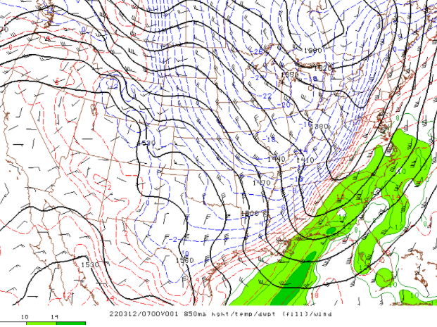 |
| Figure 1: 300mb Heights, Divergence, and Winds at 2 AM EST on March 12th | Figure 2: 500mb Heights Temperatures, and Winds at 2 AM EST on March 12th | Figure 3: 850mb Heights, Temperatures, and Winds at 2 AM EST on March 12th |
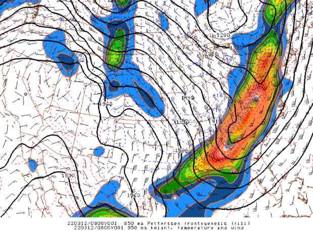
The strong low-level jet pulled much colder arctic air into the Tennessee Valley and southern Appalachian region. The tight temperature gradient and strong pressure rises produced strong northwest flow conditions with 850mb winds of 30-40kts. The strong cold air advection quickly changed the rain to sleet, then snow over the entire area. The upper forcing produced strong fronto-genetic forcing across the southern Appalachian region.
 |
 |
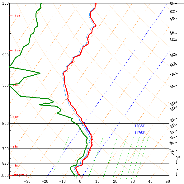 |
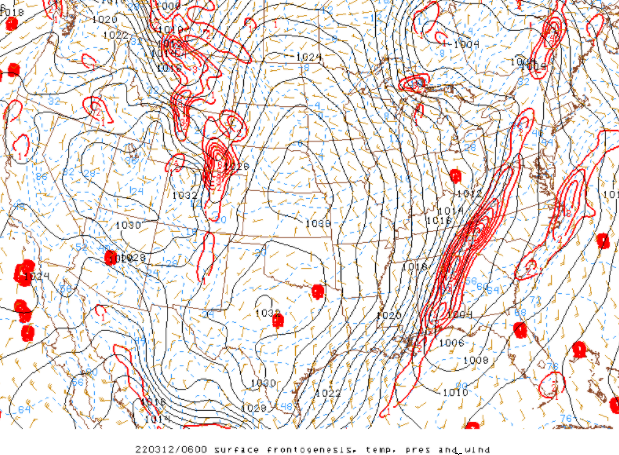
| Figure 4: 850mb Petterssen Frontogenesis at 3 AM EST on March 12th | Figure 5: Surface Frontogenesis at 1 AM EST on March 12th | Figure 6: Observed Sounding at Nashville at 7 PM EST / 6 PM CST on March 11th |
The observed evening sounding from Nashville Tennessee showed a relatively moist and cold vertical temperature profile with a fairly saturated dendritic snow growth region between the -12°C and -18°C levels. This snow growth region also had strong large-scale synoptic forcing, which produced very favorable snow production.
 |
 |
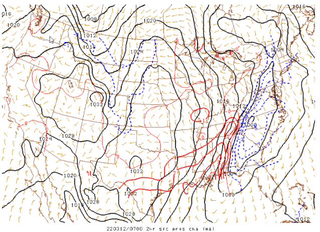 |
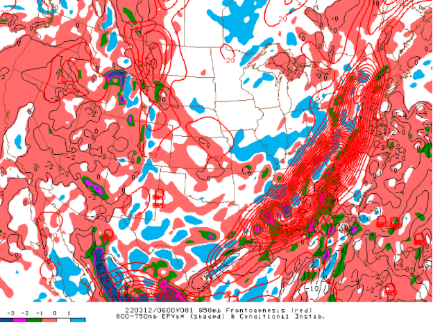
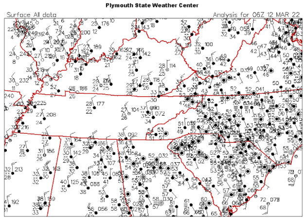
| Figure 7: Frontogenesis at 850mb and 800-750mb Equivalent Potential Vorticity (EPV) and Conditional Slantwise Instability at 1 SM EST on March 12th | Figure 8: Surface Station Plot at 1 AM | Figure 9: 2-hr MSLP Change at 2 AM EST |
The strong upper forcing in the atmosphere combined with the conditional symmetric instability (slantwise instability) and saturated environment produced a good deal of enhanced precipitation banding. The slantwise instability was extreme and produced uncommon weather phenomena of thundersnow in the area of the strongest fronto-genetic forcing.
The strong arctic cold front pulled east across the area during the night and early morning hours. The rapid temperature drop and associated pressure fall and rise couplet across the Tennessee Valley and southern Appalachian produced strong northerly winds over the area. The blustery northerly winds, combined with the heavy precipitation, produced downed trees and power lines, causing power outages. The strength of the front was enhanced by the strong upper forcing that produced widespread precipitation. Initially the precipitation began as rain, then quickly changed over to a brief period of sleet and finally a duration of heavy snow.
 |
Media use of NWS Web News Stories is encouraged! Please acknowledge the NWS as the source of any news information accessed from this site. |
|


 Local Radar
 Huntsville Radar
 Regional Satellite
 Graphical Forecast
 Weather Map