- A strong, but slow-moving, storm system developed in the lower Mississippi Valley the morning of February 13, 2003 and moved northeast toward the southern Appalachian region. Several inches of snow had fallen across the southern Appalachian region earlier in the week, with snowpack depths varying with terrain and location. It was estimated late on the 13th that up to ten inches of snow still lay on the ground on the higher ridges and mountains, especially across southwest Virginia in the Holston, Clinch, and Powell river headwater areas.
- By the afternoon of the 14th, a warm front associated with this developing storm system had reached central Alabama and Georgia with a strong moist southerly flow behind it. A steady, soaking rain began across the southern Appalachian region on the 14th, causing the snowpack in the higher elevations to melt. Rainfall rates were on the moderate to heavy side, with the heaviest rainfall rates observed along the Cumberland Plateau and in the Sequatchie Valley. This warm front continued to move north to the Kentucky-Tennessee state line by the early morning hours of the 15th. Steady moderate to heavy rain continued past midday on the 15th, with river flood warnings issued as river levels began to rise. It is believed that snowpack on the ground in Virginia contributed to flooding on the Holston, Powell, and Clinch systems. As the 15th progressed, the warm front became stationary and hovered around the southwest Virginia area, providing an additional focus for heavier rains.
- By the morning of the 16th, the ground across the southern Appalachian region was fully saturated with small streams everywhere flowing out of their banks, with larger streams and rivers starting to show either significant rises or flooding. By midday on the 16th, the surface low pressure area moved into southeast Tennessee bringing additional moderate to heavy rain. A break occurred from the 18th to the 20th, with colder temperatures and light snow and rain showers occurring intermittently. Widespread flooding continued in nearly every county in the Morristown forecast area, with few exceptions. Emergency personnel from the local level to FEMA took the opportunity to ascertain damages. Fortunately, while a couple of injuries occurred (one severe), no fatalities were reported. Preliminary damage in the Morristown forecast area exceeded $4,000,000.
- The next system affected the area beginning on the 21st, while cleanup was still going on for the previous weekend with many areas remaining flooded. This next system did not produce as much rain as the earlier system, but it did cause some rivers to rise above flood stage with more flooding occurring in areas which had not really recovered from the first round.
- Mudslides were widespread across the region, with one in particular causing a lot of damage in Knox County where an entire apartment building collapsed. This caused severe injuries to one resident as he was trapped in the collapsed building. Damage to public infrastructure occurred in nearly every county in the area including destroyed and damaged bridges, tiles, public buildings (fire stations, 911 centers, city halls, etc.), and to private property, including homes, basements, private driveways, automobiles.
- While no rivers reached new record levels, the widespread nature of the event, the number of people affected in a significant way, and the dollar amount of damage combined to make this flood event memorable. A summary of estimated snow water equivalent (pre-storm) from February 1-10 with rainfall estimates by county follows:
| County |
Precip Feb 1-10 (incl SWE est) |
Avg (high) 48 hour rain (ending 12z 2/17) |
Feb 14-17 Highest |
Feb 18-23 Highest |
Feb 1-23 (est avg liq equiv, incl SWE) |
| Anderson |
2.04 |
5.53 (6.33) |
8.53 |
2.71 |
10.66 |
| Bledsoe |
1.98 |
3.03 (3.03) |
5.52 |
NA |
>7.5 |
| Blount |
2.06 |
|
3.89 |
1.22 |
6.07 |
| Bradley |
0.99 |
|
2.99 |
0.81 |
3.97 |
| Campbell |
2.08 |
3.12 (3.12) |
4.55 |
0.44 |
7.07 |
| Carter |
2.01 |
|
1.77 |
1.79 |
5.32 |
| Cherokee, NC |
1.48 |
|
2.31 |
0.56 |
3.54 |
| Claiborne |
1.6 |
3.68 (4.27) |
5.7 |
0.63 |
7.28 |
| Clay, NC |
1.17 |
|
1.14 |
0.46 |
2.77 |
| Cocke |
1.66 |
|
1.9 |
1.04 |
4.31 |
| Grainger |
1.43 |
4.04 (4.04) |
5.45 |
0.97 |
7.85 |
| Greene |
1.58 |
|
2.09 |
NA |
>3.67 |
| Hamblen |
1.6 |
2.41 (2.71) |
3.37 |
1.08 |
6.02 |
| Hamilton |
1.41 |
|
4.29 |
0.37 |
5.61 |
| Hancock |
1.36 |
|
NA |
NA |
>1.36 |
| Hawkins |
1.83 |
2.14 (2.38) |
3.57 |
1.15 |
6.28 |
| Jefferson |
1.48 |
2.08 (2.71) |
3.89 |
1.65 |
6.22 |
| Johnson |
2.19 |
|
NA |
2.22 |
>3.89 |
| Knox |
1.63 |
4.18 (5.03) |
5.39 |
0.68 |
7.7 |
| Lee |
2.56 |
3.57 (4.27) |
NA |
1.08 |
>3.49 |
| Loudon |
1.69 |
|
7.17 |
0.5 |
8.65 |
| Marion |
1.25 |
2.79 (2.79) |
NA |
NA |
>1.25 |
| McMinn |
0.8 |
2.83 (2.83) |
4.71 |
1.1 |
6.33 |
| Meigs |
1.53 |
3.73 (4.62) |
7.15 |
0.54 |
8.73 |
| Monroe |
1.91 |
|
2.15 |
0.97 |
5.03 |
| Morgan |
2.56 |
3.73 (4.60) |
6.92 |
0.33 |
8.51 |
| Polk |
1.36 |
|
NA |
0.84 |
>1.80 |
| Rhea |
2.07 |
4.81 (5.54) |
8.3 |
0.39 |
9.66 |
| Roane |
1.98 |
5.70 (5.70) |
7.94 |
NA |
>9.92 |
| Russell |
2.18 |
|
2.88 |
1.14 |
5.69 |
| Scott, TN |
1.92 |
3.04 (3.04) |
4.1 |
0.54 |
6.56 |
| Scott, VA |
2.45 |
2.56 (2.72) |
3.93 |
1.6 |
7.19 |
| Sequatchie |
1.23 |
|
NA |
NA |
NA |
| Sevier |
2.88 |
|
4.09 |
1.24 |
7.07 |
| Sullivan |
2.15 |
|
1.99 |
NA |
>3.93 |
| Unicoi |
1.92 |
|
NA |
NA |
NA |
| Union |
1.08 |
4.04 (4.69) |
6.19 |
NA |
>6.07 |
| Washington, TN |
1.26 |
|
2.09 |
1.15 |
4.2 |
| Washington, VA |
2.92 |
|
2.64 |
1.99 |
6.2 |
| Wise |
2.62 |
2.72 (3.72) |
6.08 |
1.84 |
7.64 |
A few pictures from the February 2003 flooding
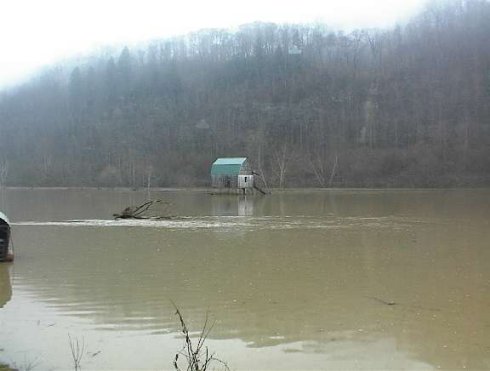
The Clinch river in flood along Highway 33 in Hancock County.
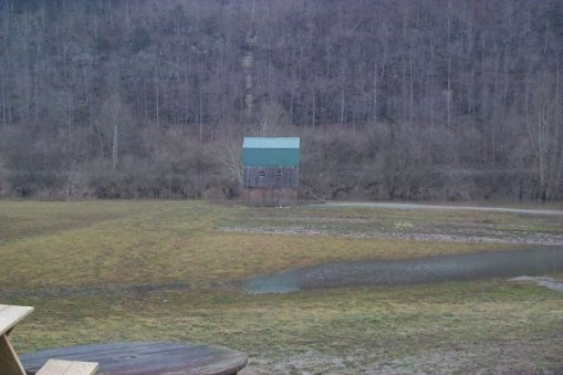
Same view, but after the flood. The Clinch river is visible in its banks, on the right of the house. Even though it is back in its banks, its level is still high. There is a reason the house is built on stilts.
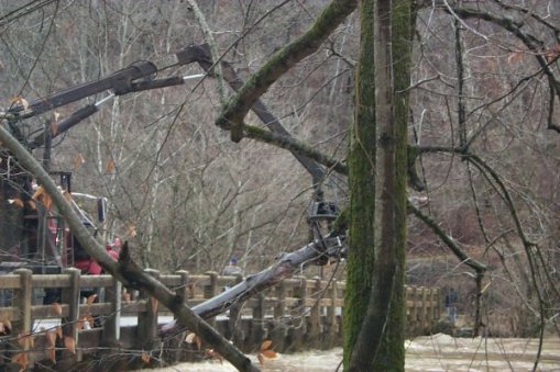
Removing log jam on the Riverside Bridge on the Powell River in Claiborne County. The river was two feet higher on the upstream side of the bridge, than on the downstream side, due to the log jam. This forced the water to flow around the bridge, flooding roads on both sides.
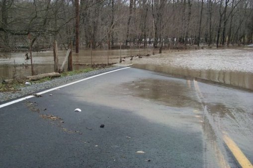
Highway 63 on the Claiborne-Hancock County line. The Powell River had been over the 4 foot fence posts at its height. In this view, it is still 3 feet deep on the road and too dangerous to drive through.

Water pouring from a cave into the Powell River in Claiborne County, which is already in flood. Because of the many caves and underground streams in this region, forecasting flooding can be challenging.
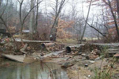
A small stream totally destroyed this private bridge in Marion County. Even little creeks like this one can be killers.
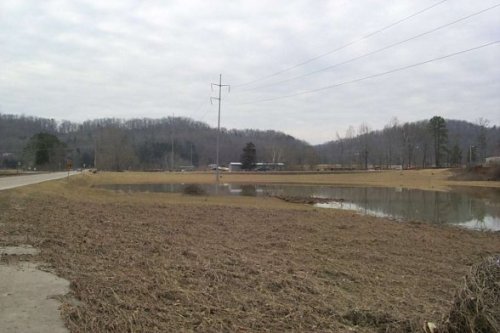
Poplar Creek near Dyllis in Roane County is perhaps 25 feet wide on a normal day. During the flood, the creek was over 200 yards wide. In this picture, the creek is back in its banks behind the building in the center of the view.
|


 Local Radar
 Huntsville Radar
 Regional Satellite
 Graphical Forecast
 Weather Map