Wake Low Severe Wind Events in the Mississippi River Valley: A Case Study of Two Contrasting Events
by
David M. Gaffin
ABSTRACT
- Severe winds, in excess of 50 knots (25 m s-1), brought widespread damage across the mid Mississippi valley on the mornings of 11 April 1995 and 28 April 1996. These severe winds were unusual and unexpected as they trailed behind stratiform precipitation areas where severe weather is not normally expected. The wake low on 11 April 1995 appeared to be the result of strong adiabatic warming due to dry air subsidence while the wake low on 28 April 1996 appeared to be associated with a gravity wave.
- Because wake lows are short-lived mesoscale phenomena, they are generally not well understood by the operational forecasting community and have been nearly impossible for forecasters to predict. With the modernization of the National Weather Service, it may become feasible to anticipate and track these mesoscale phenomena with Doppler radar, surface observations and finer resolution models. With an evaluation of some of the differences and similarities in the generation and maintenance of severe wake lows, operational forecasters can better understand these potentially severe phenomena and provide the public with useful information on these unusual events.
1. Introduction
- Unexpected high winds, occurring behind a band of stratiform rain, brought widespread damage across the mid Mississippi valley on the mornings of 11 April 1995 and 28 April 1996. Wind gusts measured over 50 knots (25 m s-1), which is considered severe by the National Weather Service, struck many counties across Arkansas, Missouri, Mississippi, and Tennessee on 11 April 1995 and across Missouri and Illinois on 28 April 1996. These severe winds were unique in that they originated from an easterly direction, opposite the direction of movement of the system, and occurred as the rain ended. Also, these severe winds were not predicted and generally caught forecasters by surprise since they did not occur directly with any severe thunderstorms.
- These winds have been documented before and defined as the result of a 'wake low' formation (Fujita, 1955). Fujita identified four stages in the development of prefrontal squall lines (Fig. 1) in which a small mesohigh formed as a result of rainfall evaporation (initiation stage), grew to over 150 km in diameter (development stage), reached maximum intensity with a mesolow developing behind (mature stage) and then dissipated with the mesolow reaching minimum pressure (dissipation stage) (Fujita, 1959, 1963). Results from recent studies have associated wake low development and amplification with subsidence warming (Fig. 2) (Johnson and Hamilton, 1988) and gravity wave formation (Bosart and Seimon, 1988).
- Johnson and Hamilton (1988) proposed that wake lows were the result of subsidence warming which was maximized at the back edge of a trailing stratiform precipitation area where there was insufficient sublimation and evaporative cooling to offset adiabatic warming. Stumpf et. al. (1991) also concluded that the trailing stratiform precipitation region of mesoscale convective systems can be dynamically significant, by generating rapidly descending inflow jets at their back edges, producing pronounced lower-tropospheric warming, intense surface pressure gradients and strong low level winds. Similar conclusions were drawn by Zhang and Gao (1989) in a numerical modeling study. Recently, Gallus (1996) found, using a numerical modeling study, that when precipitation rates are prescribed to decrease with time, as might occur with collapsing precipitation areas, microphysical cooling may become sufficiently small as to induce strong subsidence and an intense wake low.
- Wake low development and amplification have also been associated with gravity waves. Bosart and Seimon (1988) proposed that forced subsidence to the rear of convective lines in the presence of a deep, cold and stable boundary layer contributed to gravity wave genesis and amplification. Uccellini and Koch (1987) found that many large-amplitude gravity waves form north of a surface frontal boundary, an area characterized by strong lower tropospheric thermal inversions. Also, a jet streak propagating away from a geostrophic jet maximum toward a downstream ridge in the upper troposphere was commonly observed in their thirteen case studies. Geostrophic adjustment and vertical shear instability were theorized to be important in the generation of gravity waves as gravity waves were commonly confined to a region between an inflection axis and the downstream ridge axis in the 300 mb height field and in an area with strong vertical shear. The presence of a lower tropospheric inversion capped by a large conditionally unstable layer, as identified by Lindzen and Tung (1976), was found to be necessary for gravity wave maintenance in order to provide a wave duct which would prevent rapid wave dispersion. Recently, Koch and O'Handley (1997) proposed procedures for the operational forecasting and detection of mesoscale gravity waves which involved identifying typical synoptic conditions and searching mesoscale model data for necessary ducting inversions.
- As will be discussed further in the following sections, the wake low event on 11 April 1995 appeared to develop due to adiabatic warming induced by strong subsidence while the wake low on 28 April 1996 exhibited characteristics of a wake low associated with a gravity wave. The objectives of this paper are (1) to examine the similarities and differences in the synoptic and mesoscale conditions and the generating mechanisms of the wake lows on 11 April 1995 and 28 April 1996, and (2) to examine the operational forecaster's ability to track and anticipate these potentially severe and atypical wind events.
2. The Wake Low Event on 11 April 1995
a. Synoptic scale setting
- The synoptic scale setting at 1200 UTC on the morning of 11 April 1995 revealed a strong dynamic system across the Mississippi river valley (Fig. 3). A surface low was situated over northwest Missouri with a strong but slow moving cold front extending south across central Arkansas into Louisiana. There was a strong baroclinic zone as evident by the sharp temperature contrast on either side of the front. Stations across Arkansas and Tennessee were reporting temperatures in the 60s and 70s in the warm sector ahead of the front with temperatures in the 20s and 30s being reported across Kansas and Oklahoma in the cold sector. A 500 mb low located over southwestern Nebraska with a deep trough extending across the central and southern Plains placed much of the lower Mississippi River valley in a diffluent zone ahead of the trough. A strong 500 mb vorticity maximum was also located near the base of the trough over Texas.
- Upper air analysis revealed a strong low level jet at 850 mb (Fig. 4a), with wind speeds in excess of 50 knots (25 m s-1), over much of the lower Mississippi valley which provided strong warm air advection across east Arkansas and west Tennessee. This 850 mb jet helped to trigger convection on the morning of 11 April 1995 which was generally non-severe as it moved across the Mississippi river valley. At 200 mb (Fig. 4b), the lower Mississippi River valley was located in a diffluent zone to the right, east-southeast, of the entrance region of a jet streak, with wind speeds in excess of 100 knots (50 m s-1), which was propagating toward a ridge axis downstream. This finding helps to indicate that geostrophic adjustment processes, which can trigger gravity waves, may have been occurring across the lower Mississippi river valley on the morning of 11 April 1995. Most geostrophic adjustment processes which can trigger gravity waves occur between the exit region of a geostrophic wind maximum and the entrance region of an upper level jet streak propagating toward a downstream ridge axis (Uccellini and Koch, 1987). The 200 mb height field was evaluated in this study, in contrast to the 300 mb analysis done by Uccellini and Koch (1987), since the jet stream is normally found higher during the warmer months of late spring.
b. Wake low event
- Tracking mesoscale phenomena such as wake lows is difficult with surface observations as surface observations usually have insufficient spatial resolution (Fig. 5). This was the case on 11 April 1995 as high winds developed behind a non-severe stratiform precipitation area which formed ahead of a strong but slow moving cold front. The wake low first became apparent around 0900 UTC (Fig. 6) as rapid pressure falls of greater than 4 mb in less than an hour, accompanied by strong gusty winds, were first reported in south central Arkansas. This wake low moved north-northeast producing two separate wind maxima and pressure minima by 1200 UTC. Stations which reported pressure falls of 4 mb or greater in an hour or less were used to determine the path of the wake low. This wake low produced hourly pressure falls up to 10 mb and wind gusts up to 55 knots (27.5 m s-1) from the east-southeast at Little Rock by 1015 UTC while moving north-northeast at 42 knots (21 m s-1) across central and northeast Arkansas, trailing closely behind the back edge of the precipitation area (Fig. 7). Jonesboro reported pressure falls of 4.8 mb within an hour and wind gusts up to 36 knots (18 m s-1) from the east-southeast at 1253 UTC while Cape Girardeau in southeast Missouri reported pressure falls of 5.8 mb within an hour and wind gusts up to 49 knots (24.5 m s-1) from the east-southeast by 1423 UTC. This wake low diminished after 1400 UTC as the northern extent of the precipitation area diminished. In figure 7, hourly pressure, wind and radar observations were used to track the wake low while special observations taken between the hours were used to show wind maxima and pressure minima. The hours used were those in which a wind maxima and a pressure minima were evident at the observing stations. This figure shows how mesoscale phenomena such as wake lows are difficult to track from hour to hour as surface observation networks often lack sufficient spatial resolution. The advent of Doppler radar has made tracking wake lows easier and more practical for forecasters.
- Another separate wake low tracked further southeast across northern Mississippi after 1100 UTC, following closely behind a slower moving convective precipitation area. Pressure falls up to 4.5 mb within an hour and wind gusts up to 38 knots (19 m s-1) were reported at Tupelo, Mississippi by 1600 UTC. Also, many reports of wind damage were received from across northern Mississippi between 1300 and 1700 UTC. This wake low diminished after 1900 UTC as the precipitation area ahead of it diminished in intensity. An analysis of the wind and pressure time series (Fig. 8) from selected stations in the path of the wake low indicated that the strongest wind gusts occurred just before the lowest pressure readings. Also, the winds observed with the wake lows on 11 April 1995 were from the east-southeast while the wake lows themselves were moving east-northeast. These facts would help to indicate that the winds observed with the wake lows on 11 April 1995 were the result of a strong pressure gradient.
c. Mesoscale setting
- The Velocity Azimuth Display (VAD) wind profile from the Doppler radar at Memphis (KNQA) (Fig. 9) revealed strong directional shear with veering wind profiles. A strong low level jet of 50 knots (25 m s-1) and greater was evident on the Memphis VAD wind profile around 850 mb (four to six thousand feet). It is likely that this low level jet helped to sustain the observed precipitation through strong convergence which modified the local environment. The combination of a strong mesohigh produced by strong precipitation downdrafts and a trailing mesolow deepened by strong adiabatic warming induced by dry air subsidence, likely created the necessary pressure gradient which ultimately produced the strong winds observed at the surface.
- Deep layers of dry air were certainly evident the morning of 11 April 1995. Sounding data at 1200 UTC from Little Rock, Arkansas (LIT) (Fig. 10a), which is representative of the air mass found trailing the passage of the wake low, revealed a relatively stable air mass with a dry layer of air between 900 and 750 mb and a significantly drier layer between 600 and 400 mb. The boundary layer up to around 900 mb was relatively moist and nearly saturated due to the recent rainfall. The sounding from Nashville, Tennessee (BNA) at 1200 UTC (Fig. 10b), which is representative of the pre-convective airmass ahead of the wake low producing system, revealed a slightly unstable airmass with a large dry layer at mid levels (800 to 500 mb) but at a lower altitude than Little Rock. Both soundings resembled the 'onion' shaped sounding typically observed with mesoscale convective systems (MCS) in which a well-defined descending rear-inflow jet existed (Zipser, 1977; Johnson and Hamilton, 1988; Stumpf et al., 1991). A rear inflow jet on 11 April 1995 likely helped to produce dry air subsidence at the back edge of the MCS which induced a strong wake low through adiabatic warming.
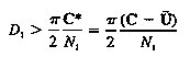
- Also, both soundings revealed weak inversions around 800 mb above a conditionally unstable boundary layer. Lindzen and Tung (1976) theorized that an inversion adjacent to the surface underneath a large conditionally unstable layer was necessary for ducting and maintenance of gravity waves which are possible generating mechanisms of wake lows. The soundings on the morning of 11 April 1995 revealed an inversion that was neither adjacent to the surface nor deep enough to sustain a gravity wave. Lindzen and Tung's wave duct theory required that a statically stable inversion layer have a thickness (D) of at least:
 (1)
(1)
where C* is the mean flow-relative velocity, C is the observed phase velocity of the wave, U is the observed mean wind of the stable layer in the direction of wave propagation, and N is the Brunt-Vaisalla frequency. The Brunt-Vaisalla frequency is defined as:
 (2)
(2)
where g is the acceleration due to gravity, and  is the mean potential temperature of the stable layer. Using the Nashville sounding and determining that the stable layer was located between 800 and 750 mb, the following parameters were calculated: a Brunt-Vaisalla frequency of N = 0.016 s-1 and an observed stable layer mean wind in the direction of wave propagation of U = 9 m s-1. U was calculated using a stable layer mean wind of 18 m s-1 from the direction of 190o, taken from the Nashville sounding, and an estimated wave propagation from the direction of 250o. Using an estimated observed phase speed of C = 21.3 m s-1, the critical inversion depth needed to sustain a gravity wave was found to be 1207 meters (m) which is greater than the observed inversion depth of 516 meters from the Nashville sounding. This finding would further support the idea that the wake low on 11 April 1995 was not associated with a gravity wave but likely the result of strong dry air subsidence produced by a descending rear inflow jet at the trailing end of an MCS, which is in agreement with the findings of Johnson and Hamilton (1988) and Stumpf et. al. (1991).
d. Operational forecasting
- Infrared satellite images from 11 April 1995 (Fig. 11) revealed indirect signs of dry air subsidence at the mid levels. At 0802 UTC, infrared imagery revealed cold cloud tops over Arkansas, Louisiana and Mississippi in association with an MCS. By 1045 UTC, wedges in the mid level cloud cover over central and southern Arkansas became evident which indicated dry air intrusion in the mid levels was occurring. The wake low at this time was located just east of Little Rock in central Arkansas. These cloud wedges indicating dry air intrusion in the mid levels were evident throughout the lifetime of the two separate wake lows. While satellite pictures alone could not help forecasters predict a wake low, they could aid the forecaster in identifying mid level dry air subsidence which would help verify the existence of a wake low.
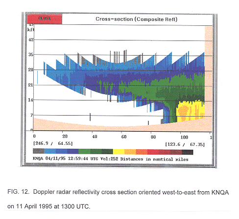
- With the advent of Doppler radar, forecasters were able to identify and track the high winds associated with the wake lows as they propagated across the Mississippi river valley. The vertical reflectivity cross section from 11 April 1995 (Fig. 12), compiled along a west to east line across the back edge of the MCS over northern Mississippi, revealed the presence of strong dry air subsidence immediately behind the main precipitation area. The absence of precipitation below 10000 feet (4.3 km) behind the main precipitation area along with a downward sloping trailing precipitation area above 10000 feet compares well to radar cross sections from previous studies concerning descending rear inflow jets (Rutledge et al., 1988). This radar cross section further supports the idea that the wake low on 11 April 1995 was manifested by adiabatic warming induced by strong dry air subsidence occurring in association with a descending rear inflow jet.
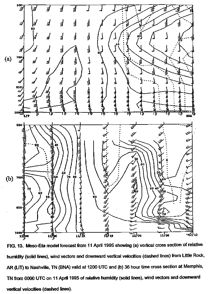
- Because wake lows are short-lived mesoscale events, anticipating wake lows hours before they develop presents a difficult task for the operational forecaster. Most operational forecasts involve guidance from the Nested Grid Model (NGM) and Eta models which both had horizontal grid resolutions of around 80 km in April 1995. With a horizontal resolution of 80 km, the best mesoscale feature which could be resolved by the model is the development of a well-defined MCS. Mesoscale models available at the time, such as the meso-Eta model with a 29 km resolution, are a better source to evaluate wake low potential. However, even with this finer resolution, forecasting wake low development remains difficult if not impossible as the meso-Eta model did not indicate strong dry air subsidence behind an MCS (Fig. 13).
- On 11 April 1995, both the NGM and Eta models predicted a strong low level jet at 850 mb and a deep layer of dry air (<70% relative humidity) between 850 and 500 mb. However, both models failed to predict the strong subsidence associated with the mesoscale convective interactions which likely produced this wake low. The 0300 UTC initialized meso-Eta model revealed a strong low level jet in excess of 50 knots (25 m s-1) at 850 mb as well as a deep layer of dry mid tropospheric air between 800 and 500 mb in the vertical cross section and time cross section from 11 April 1995 (Fig. 13). Around 1800 UTC, some weak downward vertical velocities were indicated along with a slight lowering of dry air at the mid levels, but the operational forecaster would have had a difficult time predicting strong dry air subsidence as the meso-Eta model did not reveal strong downward vertical velocities in the boundary layer. However, the forecaster could have used the knowledge of a deep layer of dry mid level air in combination with radar indications of an MCS and sharp reflectivity gradients at the back edge of the MCS to conclude that an intense wake low was possible.
3. The Wake Low Event of 28 April 1996
a. Synoptic scale setting
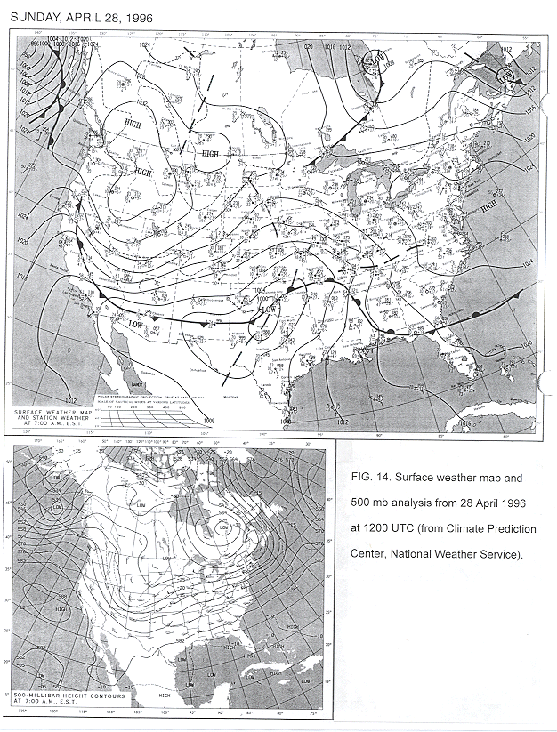
- The synoptic scale features on 28 April 1996 were not as dynamically strong as on 11 April 1995, but were more typical of gravity wave formative events. At 1200 UTC, a surface low was located over southwest Oklahoma with a warm front extending east and north across northeast Oklahoma, north Arkansas and west Tennessee (Fig. 14). The Missouri and Illinois region was located north of this warm front which is a favored area for gravity wave development, according to Uccellini and Koch (1987). Surface troughs were also located across east Kansas and west Missouri as well as from southeast Missouri across southern Kentucky. These troughs served as focal points for the development of a mesoscale convective system (MCS) during the early morning hours of 28 April. At 500 mb, a weak, positively tilted trough was located generally along the leading edge of the Rocky Mountains with a convectively induced vorticity maximum centered over western Iowa. In general, the 500 mb flow appeared to be more zonal than the 11 April case.
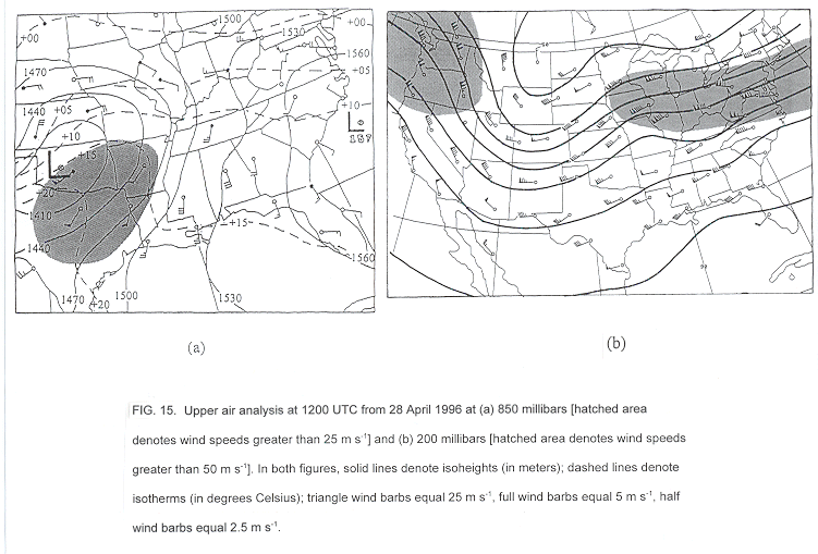
- A low level jet at 850 mb (Fig. 15a) was located across Texas, Oklahoma and Arkansas at 1200 UTC with the mid Mississippi River valley located in an area of strong convergence along the nose of the jet. This convergence helped to induce a mesoscale convective system over Missouri on the morning of 28 April 1996. At 200 mb (Fig. 15b), a jet streak, with winds in excess of 100 knots (50 m s-1), was located across the Great Lakes region propagating away from the ridge position over the upper Mississippi Valley. The absence of a jet streak ahead of the trough and approaching a downstream ridge axis would suggest that geostrophic adjustment processes were not likely occurring on 28 April 1996. However, other forcing mechanisms such as strong vertical wind shear and deep convection may have contributed to the generation of this gravity wave associated wake low. It has been theorized that deep convection alone, such as the MCS observed on 28 April 1996, can provide ample gravity wave forcing (Raymond, 1975).
b. Wake low event
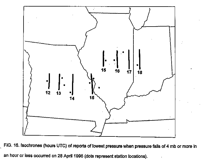
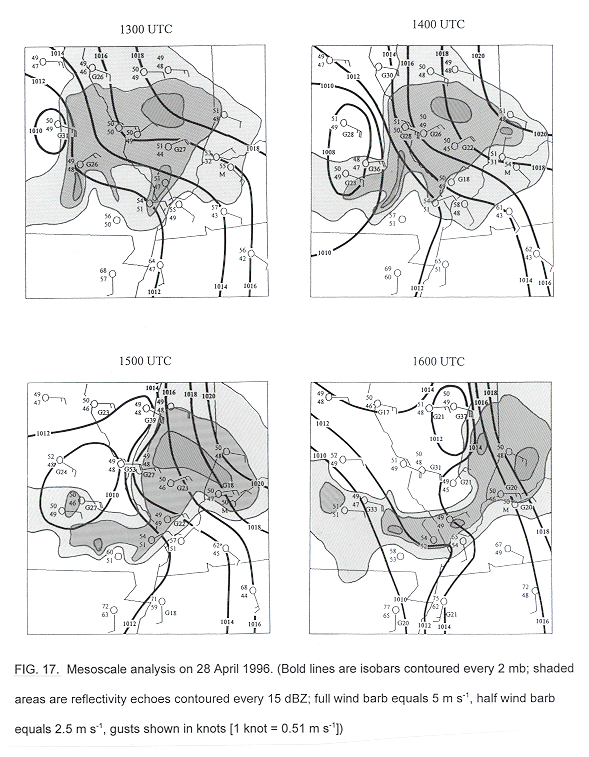
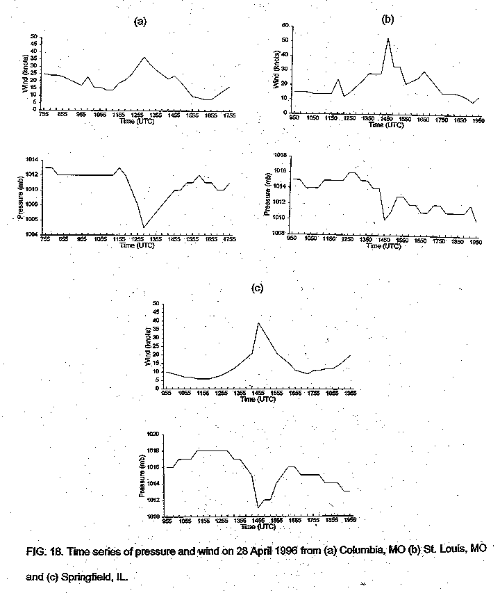
- The wake low event observed during the morning of 28 April 1996 first became apparent across central Missouri around 1200 UTC near Sedalia (Fig. 16). Stations reporting pressure falls of 4 mb or greater in an hour or less were used to track this wake low. This wake low moved east around 50 knots (25 m s-1) directly behind the back edge of an MCS (Fig. 17). Rapid pressure falls of 8.0 mb within an hour and strong easterly wind gusts up to 40 knots (20 m s-1) were reported at Columbia in central Missouri. This wake low intensified by 1500 UTC as it produced pressure falls of 6 mb within an hour and wind gusts up to 62 knots (31 m s-1) at 1438 UTC in the St. Louis metropolitan area. This wake low rapidly diminished over southern Illinois after 1500 UTC while another wake low developed over central Illinois. Springfield and Decatur reported hourly pressure falls of 8.1 and 6.1 mb by 1512 and 1550 UTC respectively with accompanying wind gusts around 40 knots (20 m s-1). An analysis of the wind and pressure time series from selected stations (Fig. 18) indicated that the strongest wind gusts occurred simultaneously with the lowest pressure readings, which is indicative of a gravity wave. Also, the fact that the wake lows moved due east, parallel to the observed surface easterly wind flow, would help support the idea that these wake lows were associated with a gravity wave.
c. Mesoscale setting
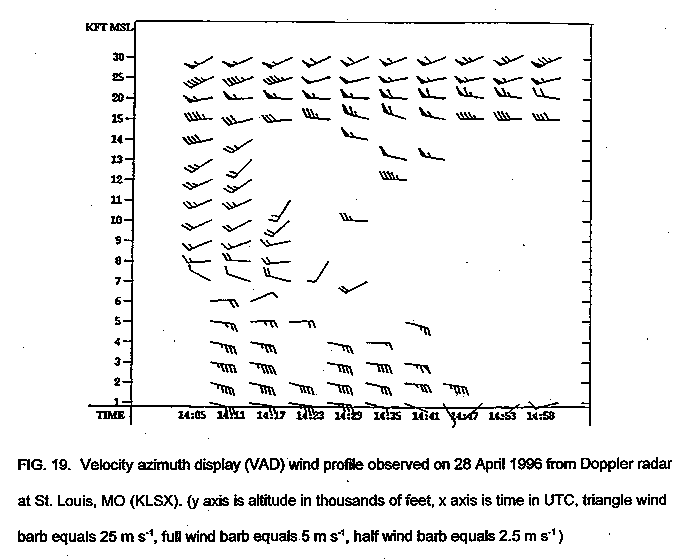
- The VAD wind profile (Fig. 19) from the Doppler radar at St. Louis, Missouri (KLSX) revealed strong vertical wind shear with veering wind profiles. In fact, the KLSX wind profile revealed an abrupt change in wind direction between six and seven thousand feet (1.8 and 2.1 km). This strong vertical wind shear indicates that shear instability, in addition to convection, could have also contributed to the source and amplifying mechanisms on 28 April 1996 which were necessary to induce and maintain a gravity wave associated wake low.
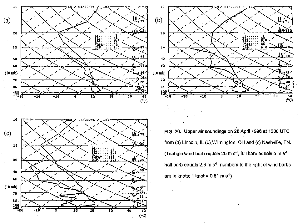
- Sounding data from Lincoln, Illinois on 28 April 1996 at 1200 UTC (Fig. 20a) revealed a statically stable boundary layer with a large unstable layer above 900 mb. Also, a dry layer was evident at the mid levels, generally between 500 and 400 mb, as seen on the soundings from Nashville, Tennessee and Wilmington, Ohio (Figs. 20b,c). The Lincoln sounding was nearly saturated at mid levels due to the fact that it was launched during a rain shower. In contrast to the 11 April soundings, all three of the 28 April soundings revealed a boundary layer inversion capped by a large unstable layer which Lindzen and Tung (1976) found as being a necessary ducting mechanism for the maintenance of gravity waves. Using data from the Lincoln, Illinois (ILX) sounding and determining that the frontal stable layer extended from the surface up to 700 mb, the following parameters were determined: an observed stable layer mean wind in the direction of wave propagation of U = -3.2 m s-1, and a Brunt-Vaisalla frequency of N = 0.014 s-1. U was calculated using a stable layer mean wind of 7.5 m s-1 from the direction of 155o, taken from the Lincoln sounding and an estimated wave propagation direction from 270o. Using the Lindzen and Tung equation and an estimated observed phase speed of C = 25.0 m s-1, the critical depth, D, was found to be 3162 meters which is generally the same depth as the observed stable layer depth of 3167 meters at Lincoln, Illinois. This finding would support the idea that the wake low observed on 28 April 1996 was associated with a gravity wave.
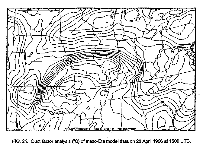
- Koch and O'Handley (1997) recently recommended that a duct factor analysis be performed on meso-Eta model data to determine the exact location of possible gravity wave formation by revealing the location of the strongest ducting inversion. The duct factor analysis presented by Koch and O'Handley involves calculating the following equation:
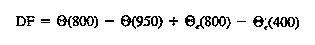 (3)
(3)
where q is the potential temperature and qe is the equivalent potential temperature at the noted pressure levels. This duct factor analysis includes a measure of the strength of the unstable layer above the inversion which Lindzen and Tung (1976) found necessary as a reflecting layer for gravity wave energy. While this duct factor analysis does not provide the forecaster with a specific ducting depth value, it does give the forecaster an idea of the optimum location where a gravity wave could form by showing the area with the deepest ducting inversion. The results of the duct factor analysis at 1500 UTC on 28 April 1996 (Fig. 21) calculated using the 0300 UTC initialized meso-Eta model data clearly shows that the Missouri and southern Illinois area would be the optimum location for a gravity wave event. This finding further supports the idea that the wake low observed on 28 April 1996 was associated with a gravity wave.
d. Operational forecasting
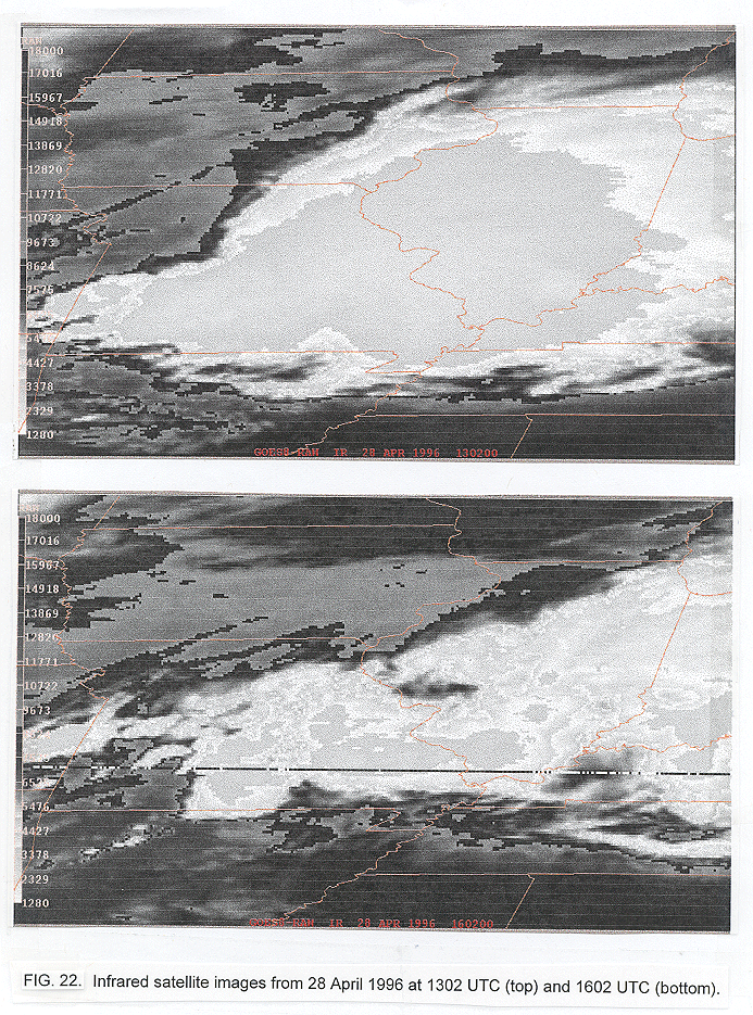
- Infrared satellite images from 28 April 1996 revealed some subtle signs of subsidence with the gravity wave associated wake low. A sharp back edge to the cloud field can be seen across Missouri at 1302 UTC (Fig. 22) with a slight indentation developing over central Missouri where the gravity wave associated wake low was developing. The satellite picture at 1602 UTC revealed some indications of mid level subsidence as the wake low matured and propagated east across west-central Illinois. Once again, these satellite images could not have helped forecasters predict a gravity wave associated wake low on 28 April 1996, but they could have helped forecasters identify mid level subsidence which would have verified the existence of a wake low.
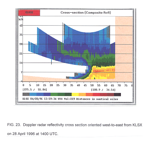
- Doppler radar tremendously aided forecasters with tracking the gravity wave associated wake lows as they moved across Missouri and Illinois. The vertical reflectivity cross section from the St. Louis Doppler radar (KLSX) on 28 April 1996, oriented west-to-east through the back edge of the MCS over central Missouri, showed a sloping precipitation structure behind the MCS as the wake low tracked across Missouri (Fig. 23). This observed structure was likely the result of strong easterly winds at low levels producing a slanting precipitation feature as the horizontal vorticity exceeded the solenoidal vorticity associated with the cold pool (Rotunno et al., 1988).
4. Conclusion
- The wake lows on 11 April 1995 and 28 April 1996 were good examples of the different synoptic conditions and generating mechanisms that can generate wake lows with severe winds in excess of 50 knots (25 m s-1). Wake lows are generally not well understood by the operational community since they trail behind precipitation areas where severe weather is not normally expected. On 11 April 1995, stations across the lower Mississippi river valley reported strong east-southeast winds along with rapid pressure falls behind an MCS with the strongest wind gusts occurring just before the lowest pressure reading. Although geostrophic adjustment processes, which can trigger gravity waves, may have been occurring on 11 April 1995, area soundings revealed weak temperature inversions that were theoretically insufficient for ducting of strong, long-lasting gravity wave activity. These soundings also revealed deep layers of dry air while the radar vertical cross section on 11 April 1995 revealed a profile which was similar to those in which a descending rear inflow jet was observed. These findings support the idea that the wake low on 11 April 1995 was the result of strong dry air subsidence in the trailing stratiform precipitation region of an MCS which induced strong adiabatic warming at the surface.
- On 28 April 1996, stations across Missouri and Illinois reported strong easterly winds along with rapid pressure falls behind the passage of an MCS. The fact that the strongest wind gusts were observed to occur simultaneously with the lowest pressure readings would help to indicate the presence of a gravity wave. Also, the Missouri and Illinois region was located in a synoptically favorable area for gravity wave formation as it was located north of a surface warm front with a boundary layer inversion of sufficient ducting depth. While geostrophic adjustment processes, which can trigger gravity waves, were likely absent on 28 April 1996, the observed MCS ahead of the wake low likely provided enough forcing for gravity wave formation. Thus, the wake low observed on 28 April 1996 was likely associated with a gravity wave.
- The common similarity between both events was a strong low level jet in excess of 50 knots (25 m s-1) at 850 mb. These low level jets likely helped to sustain the organized convection observed on both dates which modified the environment associated with both wake low events. With the 11 April 1995 event, the strong low level jet likely influenced the development of the wake low by sustaining an organized system where intense downdrafts created a strong mesohigh while descending dry air behind the system developed a strong wake low through adiabatic warming. The resulting strong pressure gradient likely created the severe winds observed with the passage of this wake low. With the 28 April 1996 event, the strong low level jet likely influenced the development of this gravity wave associated wake low by producing the mesoscale convective system which likely triggered the gravity wave associated wake low.
- Because wake lows are generally short-lived mesoscale phenomena, they have been difficult for operational forecasters to predict and detect. Soundings combined with Doppler radar data on 11 April 1995 could have alerted forecasters to the potential for wake low formation as a deep layer of dry air was observed in the mid levels while Doppler radar was indicating rapidly diminishing precipitation rates and sharp reflectivity gradients at the back edge of the precipitation field. The forecaster then should monitor surface observations, especially automated surface observing systems (ASOS) with 5 minute observations, for the possibility of rapid pressure falls and strong winds behind the precipitation field. Unfortunately, ASOS data was not widely available to forecasters in 1995 or 1996. However, with the modernization of the National Weather Service, 5 minute ASOS observations will be a valuable asset in detecting and tracking wake lows.
- Currently, operational forecasting models, such as the NGM, Eta and meso-Eta, can only alert forecasters to the possibility of the development of an MCS. Even mesoscale models, such as the meso-Eta and the recently developed 32 km Eta, still have a difficult time predicting MCSs, let alone smaller scale phenomena such as wake lows. Wake lows remain difficult, if not impossible, for operational forecasters to predict hours ahead of time. However, with knowledge of the synoptic and mesoscale conditions necessary for wake low formation, forecasters can anticipate the possibility of wake low development.
- When trying to anticipate the possibility of a gravity wave associated wake low, the forecaster should first examine whether the forecast area will be located in a synoptically favorable area for gravity wave formation, as defined by Uccellini and Koch (1987). The Missouri and Illinois region on the morning of 28 April 1996 was located north of a west-to-east oriented surface warm front with a boundary layer inversion of sufficient ducting depth located across the area. Upper level dynamics were not favorable for geostrophic adjustment processes, but forecasters could have been alert to the possibility of the observed MCS triggering a gravity wave in the favorable environment. Unfortunately, operational models could not have predicted the occurrence of this gravity wave associated wake low due to its mesoscale and short-lived nature. However, forecasters could have anticipated the possibility of a gravity wave associated wake low on 28 April 1996 by recognizing the favorable synoptic and mesoscale environment and then monitoring observing stations for sudden pressure drops behind the observed MCS.
- Forecasters could also be alerted to sudden temperature rises and dewpoint falls at observation stations when monitoring for wake lows as wake lows have been documented before as being associated with heat bursts. Surface observations on 11 April 1995 and 28 April 1996 indicated only slight temperature rises and dewpoint falls associated with the passage of the wake lows. However, temperature rises on the order of 5 to 10 degrees Celsius and dewpoint falls of 10 to 15 degrees Celsius have been documented with heat bursts occurring in association with wake lows (MacKeen et al., 1998; Bernstein and Johnson, 1994; Hunter et al., 1992; and Johnson, 1983). By monitoring surface observations for sudden temperature rises or dewpoint falls, forecasters could be alerted to adiabatic warming induced by dry air subsidence.
- Some thoughts for future research include determining how often wake lows occur and what triggers wake lows to form when the necessary synoptic and mesoscale conditions are present. There are likely many times during the year when the necessary synoptic and mesoscale conditions are present, but no wake low forms. Also, non-severe and less intense wake lows occur frequently behind squall lines, but it is important to determine the conditions which will cause these wake lows to intensify and generate severe winds. With the modernization of the National Weather Service and technological advancements such as Doppler radar, automated surface observations, improved mesoscale models and operational vertical wind profilers, it may become more feasible for operational forecasters to anticipate, detect and track wake lows. With these new technological improvements, forecasters will be able to better anticipate these potentially severe wind events and provide the public with valuable information about these atypical severe weather events.
Acknowledgments
- The author would like to thank Scott McNeil, Jeff Logsdon and George Bailey of NWSFO Memphis for their helpful computer assistance. Also, thanks to Dan Smith at Scientific Services Division of Southern Region Headquarters for his assistance in obtaining much of the data used in this study. Also, I would also like to express my appreciation to the staff at the MIT/Lincoln Labs ITWS site for providing the April 11th radar data and Dolores Keissling from UCAR-COMET for providing the meso-Eta model data.
REFERENCES
- Bernstein, B. C., and R. H. Johnson, 1994: A dual-Doppler radar study of an OK PRE-STORM heat burst event. Mon. Wea. Rev., 122, 259-273.
- Bosart, L. F., and A. Seimon, 1988: A case study of an unusually intense atmospheric gravity wave. Mon. Wea. Rev., 116, 1857-1886.
- Fujita, T.T., 1955: Results of detailed synoptic studies of squall lines. Tellus, 7, 405-436.
- ______, 1959: Precipitation and cold air production in mesoscale thunderstorm systems. J. Meteor., 16, 454-466.
- ______, 1963: Analytical mesometeorology: A review. Meteor. Monogr., 5, 77-125.
- Gallus, W. A., Jr., 1996: The influence of microphysics in the formation of intense wake lows: A numerical modeling study. Mon. Wea. Rev., 124, 2267-2281.
- Hunter, S. M., T. J. Schuur, T. C. Marshall and W. D. Rust, 1992: Electric and kinematic structure of the Oklahoma mesoscale convective system of 7 June 1989. Mon. Wea. Rev., 120, 2226-2239.
- Johnson, B. C., 1983: The heat burst of 29 May 1976. Mon. Wea. Rev., 111, 1776-1792.
- Johnson, R. H., and P. J. Hamilton, 1988: The relationship of surface pressure features to the precipitation and airflow structure of an intense midlatitude squall line. Mon. Wea. Rev., 116, 1444-1472.
- Koch, S. E., and C. O'Handley, 1997: Operational forecasting and detection of mesoscale gravity waves. Wea. Forecasting, 12, 240-269.
- Lindzen, R. S., and K. K. Tung, 1976: Banded convective activity and ducted gravity waves. Mon. Wea. Rev., 104, 1602-1617.
- MacKeen, P., D. L. Andra, and D. A. Morris, 1998: The 22-23 May 1996 heatburst: A severe wind event. PrePrints: 19th Conf. Severe Local Storms, Minneapolis, MN, Amer. Meteor. Soc., 510-513.
- Raymond, D. J., 1975: A model for predicting the movement of continuously propagating convective storms. J. Atmos. Sci., 32, 1308-1317.
- Rotunno, R., J. B. Klemp and M. L. Weisman, 1988: Theory for strong, long-lived squall lines. J. Atmos. Sci., 45, 463-485.
- Rutledge, S. A., R. A. Houze, B. I. Biggerstaff, and T. Matejka, 1988: The Oklahoma-Kansas mesoscale convective system of 10-11 June 1985: Precipitation structure and single-Doppler radar analysis. Mon. Wea. Rev., 116, 1409-1430.
- Stumpf, G. J., R. H. Johnson, and B. F. Smull, 1991: The wake low in a midlatitude mesoscale convective system having complex convective organization. Mon. Wea. Rev., 119, 134-158.
- Uccellini, L. W., and S. E. Koch, 1987: The synoptic setting and possible energy sources for mesoscale wave disturbances. Mon. Wea. Rev., 115, 721-729.
- Zhang, D., and K. Gao, 1989: Numerical simulation of intense squall line during 10-11 June 1985 PRE-STORM. Part II: Rear inflow, surface pressure perturbations and stratiform precipitation. Mon. Wea. Rev., 117, 2067-2094.
- Zipser, E. J., 1977: Mesoscale and convective-scale downdrafts as distinct components of squall-line structure. Mon. Wea. Rev., 105, 1568-1589.
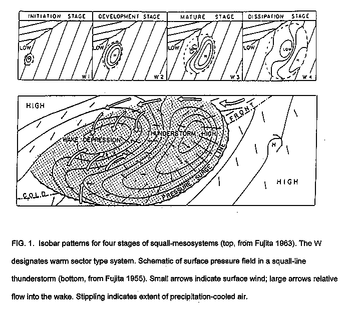
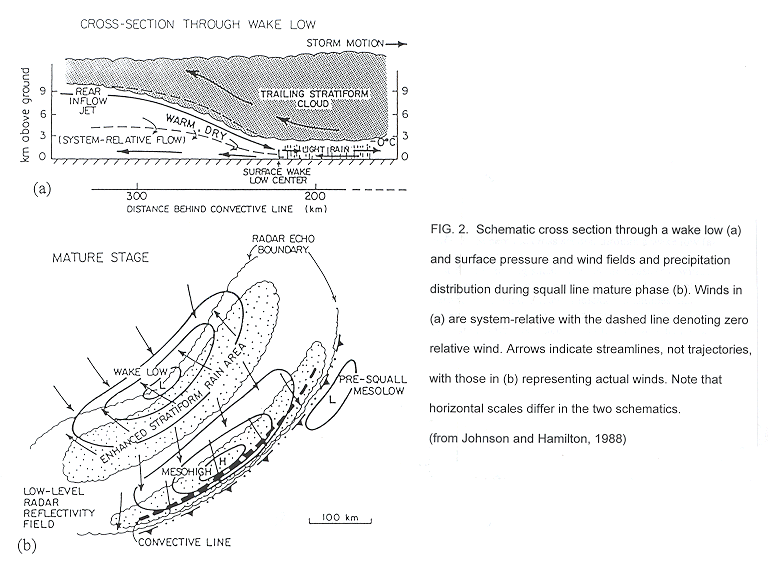
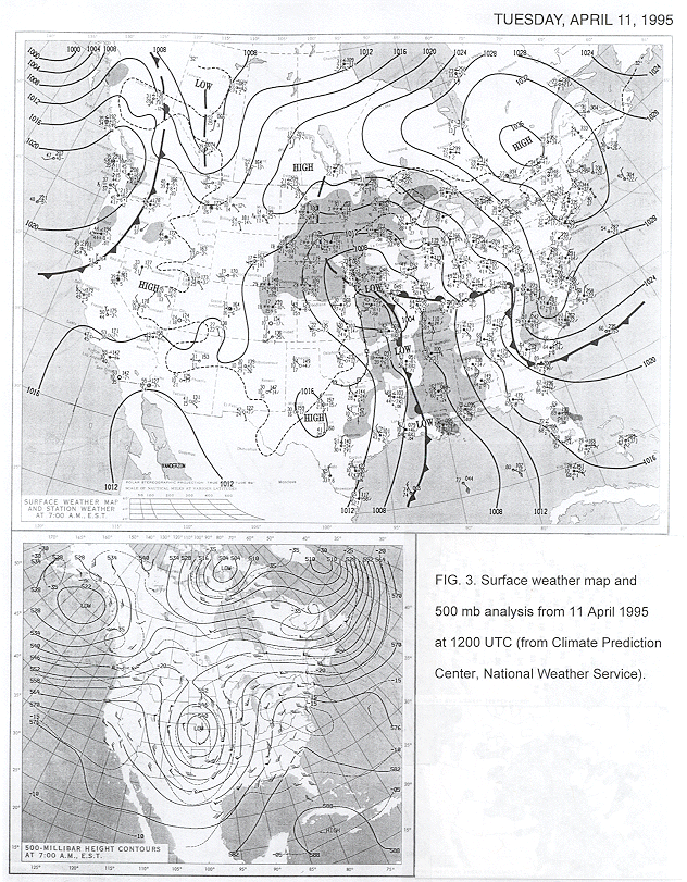
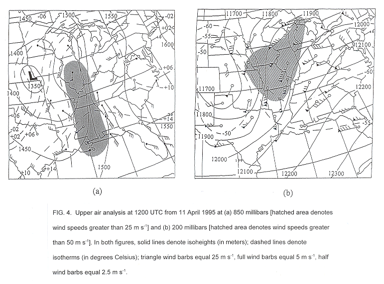

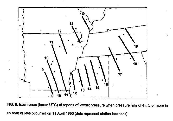
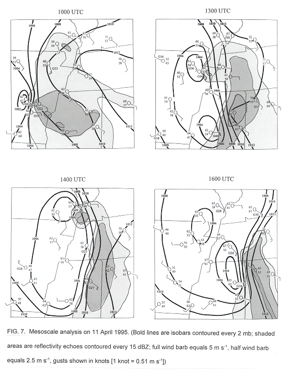
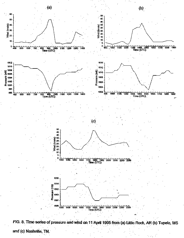
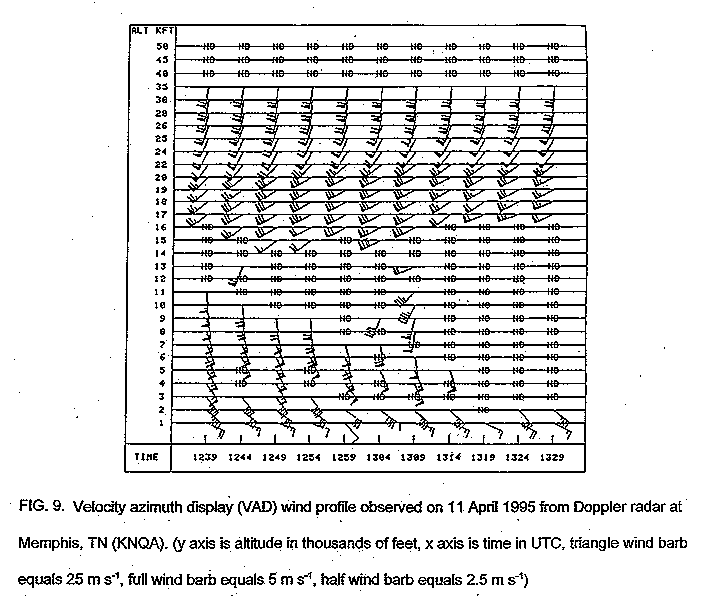
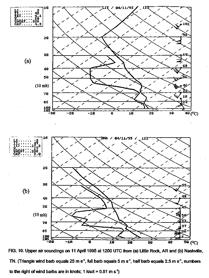

Figure 11. Infrared satellite images from 11 April 1995 at 0802 UTC (top) and 1045 UTC (bottom).


 Local Radar
 Huntsville Radar
 Regional Satellite
 Graphical Forecast
 Weather Map