Overview
A slow moving cold front developed scattered severe thunderstorms producing damaging winds across portions of the Lower Hudson Valley during the afternoon. These storms dissipated as they approached the Long Island Sound. Additional thunderstorms developed during the late afternoon and evening, but remained below severe limits. A wave of low pressure formed along the slow moving cold front during the late evening, with additional thunderstorms from Long Island Sound into Southern Connecticut. Localized flash flooding was reported in Southern Fairfield County Connecticut, but no additional severe weather was reported from these storms in the NWS NY coverage area.
Radar Summary

Click here for an interactive version of this loop. Radar loop courtesy of the Iowa Environmental Mesonet and runs from 12:00 PM EDT Tuesday, July 8 through 2:00 AM EDT Wednesday, July 9. The large yellow boxes represent severe thunderstorm watches, yellow polygons represent severe thunderstorm warnings, blue polygons represent Special Marine Warnings, and green polygons represent Flood Advisories and Flash Flood Warnings
Local Storm Reports
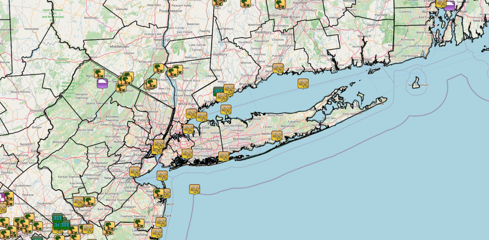
..TIME...   ...EVENT...      ...CITY LOCATION...     ...LAT.LON...
..DATE...   ....MAG....      ..COUNTY LOCATION..ST.. ...SOURCE....
            ..REMARKS..

0135 PM     Tstm Wnd Dmg     3 WNW Stony Point       41.25N 74.04W
07/08/2025                   Rockland           NY   911 Call Center

            Tree down on the exit 16 ramp of the
            Palisades Interstate Parkway.

0155 PM     Tstm Wnd Dmg     2 SE Montrose           41.22N 73.91W
07/08/2025                   Westchester        NY   Emergency Mngr

            Large tree down on power lines.

0207 PM     Tstm Wnd Dmg     3 NE Croton-on-Hudson   41.24N 73.86W
07/08/2025                   Westchester        NY   Dept of Highways

            DOT Tree down across Rte 129. All lanes
            blocked.

0207 PM     Tstm Wnd Dmg     West Milford            41.11N 74.40W
07/08/2025                   Passaic            NJ   Law Enforcement

            Tree and wires down.

0208 PM     Tstm Wnd Dmg     6 NNW Ringwood          41.19N 74.33W
07/08/2025                   Passaic            NJ   911 Call Center

            Tree down causing the closure of Jersey
            Avenue.

0211 PM     Tstm Wnd Dmg     4 NE West Milford       41.16N 74.35W
07/08/2025                   Passaic            NJ   Law Enforcement

            Trees on wires across Rocky Point Road.

0215 PM     Tstm Wnd Dmg     6 NNW Ringwood          41.18N 74.34W
07/08/2025                   Passaic            NJ   Law Enforcement

            Trees on wires.

0226 PM     Tstm Wnd Dmg     4 NNE West Milford      41.16N 74.38W
07/08/2025                   Passaic            NJ   Fire Dept/Rescue

            Trees and wires down at Lake Shore
            Drive/Warwick Tpk.

0230 PM     Tstm Wnd Dmg     1 NNE Montebello        41.14N 74.11W
07/08/2025                   Rockland           NY   Broadcast Media

            Corrects previous tstm wnd dmg report from 1
            NNE Montebello. Large tree fell onto a truck
            on Kevin Drive. The tree also blocked the
            road and took down power lines. Time
            estimated by radar.

0230 PM     Tstm Wnd Dmg     1 WNW Montebello        41.13N 74.13W
07/08/2025                   Rockland           NY   911 Call Center

            Tree down on Route 202 near Mayer Drive.
            Right lane is closed. Time estimated by
            radar.

0356 PM     Marine Tstm Wind 1 SSW New Haven Airport 41.25N 72.90W
07/08/2025  M40 MPH          New Haven          CT   Mesonet

            Corrects previous tstm wnd gst report from 1
            SSW New Haven Airport. Mesonet station XLTH
            Lighthouse Point.

0630 PM     Marine Tstm Wind 2 NNE Bayside           40.81N 73.76W
07/08/2025  M51 MPH          ANZ335             NY   Buoy

            Buoy station KPTN6 Kings Point.

0701 PM     Marine Tstm Wind 3 SW Tottenville        40.50N 74.27W
07/08/2025  M39 MPH          ANZ338             NY   Mesonet

            Mesonet site XPER at Perth Amboy.

0736 PM     Marine Tstm Wind 8 S Coney Island        40.47N 74.01W
07/08/2025  M63 MPH          ANZ338             NY   Mesonet

            NOS site at Sandy Hook.

0736 PM     Marine Tstm Wind 2 N Tompkinsville       40.66N 74.06W
07/08/2025  M44 MPH          ANZ338             NY   Mesonet

            Mesonet station ROBN4 Robbins Reef, NJ.

0749 PM     Marine Tstm Wind 2 ESE Jersey City       40.70N 74.04W
07/08/2025  M40 MPH          ANZ338             NJ   Mesonet

            Mesonet station FW2280 Jersey City.

0801 PM     Marine Tstm Wind 1 SW NYC/JFK            40.63N 73.77W
07/08/2025  M41 MPH          Queens             NY   Mesonet

            JFK ITWS sensor.

0810 PM     Marine Tstm Wind 15 S Atlantic Beach     40.37N 73.70W
07/08/2025  M43 MPH          ANZ355             NY   Mesonet

            Mesonet station 44065 15 S Atlantic Beach.

0841 PM     Marine Tstm Wind 1 S Mamaroneck          40.92N 73.73W
07/08/2025  M49 MPH          ANZ335             NY   Mesonet

            Mesonet station XLAR Larchmont Harbor.

0845 PM     Marine Tstm Wind 4 WSW Gilgo State Park  40.61N 73.42W
07/08/2025  M39 MPH          Suffolk            NY   Mesonet

            Mesonet station FW3143 West Gilgo Beach.

0856 PM     Marine Tstm Wind 2 N Glen Cove           40.90N 73.63W
07/08/2025  M58 MPH          Nassau             NY   Mesonet

            Mesonet station XBAY Bayville.

0900 PM     Tstm Wnd Gst     10 S Guilford           41.14N 72.66W
07/08/2025  M42 MPH          ANZ331             CT   Buoy

0905 PM     Marine Tstm Wind 2 S Rowayton            41.04N 73.44W
07/08/2025  M65 MPH          ANZ335             CT   Mesonet

            Mesonet site XGLL at Greens Ledge Light.

0906 PM     Marine Tstm Wind Eatons Neck             40.95N 73.40W
07/08/2025  M40 MPH          Suffolk            NY   Mesonet

            Mesonet station XEAT Eatons Neck.

0915 PM     Marine Tstm Wind 1 S Brookhaven          40.76N 72.91W
07/08/2025  M43 MPH          Suffolk            NY   Mesonet

            Mesonet station EW4378 Brookhaven.

0919 PM     Marine Tstm Wind 2 ESE Norwalk           41.08N 73.38W
07/08/2025  M58 MPH          ANZ335             CT   Mesonet

            Corrects previous non-tstm wnd gst report
            from 2 ESE Norwalk. Mesonet station XNOR 1
            ESE Norwalk.

0930 PM     Marine Tstm Wind 2 SSW Westport          41.10N 73.37W
07/08/2025  M53 MPH          Fairfield          CT   Mesonet

            Mesonet site at Cedar Point Yacht Club.

0938 PM     Flash Flood      2 WNW Rowayton          41.08N 73.47W
07/08/2025                   Fairfield          CT   Law Enforcement

            US 1 closed near Tokeneke Road in Darien CT
            due to flooding. Time estimated from radar.

            Buoy 44025.
|
The above link and map are courtesy of the Iowa State University State Mesonet (IEM) National Weather Service Text Product Archive
Surface Analysis

500 mb Analysis


 Coastal Flooding