National Weather Service United States Department of Commerce
 
 
 The Blizzard of January 4, 2018
 
 
 Impacts
  • Blizzard conditions occurred on Thursday, January 4, 2018 over Long Island as well as portions of New York City, the Lower Hudson Valley, and southern Connecticut.
    • Snowfall totals ranged from 3 to 7" across portions of interior northeast New Jersey, 6 to 10" across the lower Hudson Valley, 8 to 12" in New York City, and 12 to 16" across Long Island and southern Connecticut.
    • Snowfall rates ranged from 1 to 2 inches per hour with locally 3 inches per hour at times. This resulted in near whiteout conditions at times when combined with strong gusty winds 35 mph to 55 mph.
    • Thundersnow was observed across portions of Long Island and southern Connecticut.
  • Approximately 4,400 flights were cancelled on Thursday, January 4th, many at Kennedy, Newark, LaGuardia. Nearly 900 were also cancelled the day after the blizzard.
  • Utility companies across the east coast reported nearly 80,000 homes and businesses were without power (CBSNews).
  • There were system-wide delays and cancellations on the Long Island Railroad and numerous delays Metro North Railroad.
  • A jackknifed tractor trailer shut down Interstate 95 southbound in Darien, CT. Numerous other accidents across the Tri-State area.
 
 Other Facts
  • The development of the blizzard began along the southeast coast on Wednesday, January 3rd. An ampflying upper level trough spawned low pressure off the coast of Florida. The low underwent rapid intenisifcation from Wednesday night through the Thursday morning as it moved north-northeast along the coast. The low passed just east of the 40°N 70°W benchmark Thursday afternoon. The central pressure when the storm developed was around 1004 millibars at 1 pm Wednesday. 24 hours later, the central pressure fell to 950 mb which is a 54 millibar drop. The rapid intensification of the storm led to the heavy snow and blizzard conditions across portions of the region.  
  • Daily snowfall records for Jauary 4th were set at Bridgeport, CT (9.0"), Central Park, NY (9.8"), Islip, NY (16.0"), Kennedy, NY (8.0"), La Guardia, NY (7.4"), and Newark, NJ (8.4").
  • The blizzard occurred in the middle of an arctic outbreak that began in late December and lasted into early 2018 with many new record lows and record lowest maximum temperatures. For more information, visit http://www.weather.gov/okx/RecordCold_Dec17Jan18


Snowfall Summary


Regional Observed Snowfall


regsnow


Local Observed Snowfall


locsnow


Snowfall Reports Listing
 
New York

LOCATION          STORM TOTAL     TIME/DATE   COMMENTS
                     SNOWFALL           OF
                     /INCHES/   MEASUREMENT
...Bronx County...
   Bedford Park          11.2   330 PM  1/04  Public                  
   Morris Park           10.7   500 PM  1/04  Public
   
...Kings County...
   East Flatbush         12.4   515 PM  1/04  CoCoRaHS                
   Sheepshead Bay        12.0   700 PM  1/04  Trained Spotter
   Midwood               11.8   430 PM  1/04  Public                  
   Brooklyn              11.5   219 PM  1/04  CoCoRaHS                
   Borough Park           9.0   300 PM  1/04  Amateur Radio           
   Fort Hamilton          7.1   100 PM  1/04  CoCoRaHS 
   
...Nassau County...
   Oceanside             16.0   800 PM  1/04  Trained Spotter         
   Baldwin               15.1   745 PM  1/04  Amateur Radio 
   Carle Place           14.6   800 PM  1/04  Trained Spotter         
   New Hyde Park         14.4   800 PM  1/04  Trained Spotter         
   Wantagh               14.2  1000 PM  1/04  Trained Spotter         
   Mill Neck             14.0  1015 PM  1/04  Law Enforcement         
   Rockville Centre      14.0   600 PM  1/04  Public                  
   Massapequa            13.0   700 PM  1/04  Public                  
   Westbury              13.0   700 PM  1/04  Trained Spotter         
   1 ENE Hicksville      12.9   715 AM  1/05  CoCoRaHS                
   Old Bethpage          12.6  1100 PM  1/04  Trained Spotter         
   Plainview             12.5   800 AM  1/05  CoCoRaHS                
   West Hempstead        12.5   624 PM  1/04  Public                  
   1 WNW Manhasset       12.0   551 PM  1/04  Trained Spotter         
   Merrick               11.0   715 PM  1/04  Trained Spotter         
   Roslyn                10.0   755 PM  1/04  Public                  
   Glen Cove             10.0   800 PM  1/04  Trained Spotter         
   Garden City           10.0   747 PM  1/04  Public                  
   Old Brookville        10.0   753 PM  1/04  Public                  
   Glen Head             10.0   758 PM  1/04  Public                  
   1 E Jericho            7.0   700 AM  1/05  CoCoRaHS  
   
...New York County...
   Gramercy Park          9.8   530 PM  1/04  Public                  
   Central Park           9.8   700 PM  1/04  Park Conservancy        
   Stuyvesant Town        9.7   700 PM  1/04  CoCoRaHS                
         
...Orange County...
   Gardnertown            8.5   400 PM  1/04  Trained Spotter         
   Salisbury Mills        8.0   329 PM  1/04  Public                  
   Monroe                 7.5   301 PM  1/04  Trained Spotter         
   Highland Mills         7.4   400 PM  1/04  Trained Spotter         
   Vails Gate             6.0   241 PM  1/04  Public                  
   New Windsor            6.0   428 PM  1/04  Public                  
   Mount Hope             6.0   720 PM  1/04  Trained Spotter   
   2 SW Greenwood Lake    5.0   800 AM  1/05  CoCoRaHS    
   
...Putnam County...
   Carmel 4n             10.0   800 AM  1/05  Co-Op Observer          
   Mahopac                7.0   600 PM  1/04  Trained Spotter         
   1 S Adams Corners      6.8   800 PM  1/04  Broadcast Media         
   3 N Fahnestock State   5.4   600 AM  1/05  CoCoRaHS                
   3 S Fishkill           3.3   623 AM  1/05  CoCoRaHS         
   
...Queens County...
   Queens                13.6   316 PM  1/04  CoCoRaHS
   Howard Beach          13.2   630 PM  1/04  Newspaper 
   Rego Park             13.0   500 PM  1/04  Trained Spotter              
   Bayside               12.4   730 PM  1/04  Public                  
   Middle Village        12.3   800 PM  1/04  CoCoRaHS                
   2 NW Ozone Park       12.3   700 AM  1/05  CoCoRaHS                
   Jackson Heights       12.0   716 PM  1/04  Trained Spotter         
   Maspeth               12.0   600 PM  1/04  Public                  
   Whitestone            10.7   600 PM  1/04  Public                  
   NYC/JFK Airport        8.0   700 PM  1/04  FAA Observer            
   Whitestone             7.5   700 AM  1/05  CoCoRaHS                
   NYC/LaGuardia Airpor   7.4   700 PM  1/04  FAA Observer  
   
...Richmond County...
   Great Kills           10.8   651 PM  1/04  Public                   
   Dongan Hills          10.2   505 PM  1/04  Public    
   
...Rockland County...
   Nyack                  7.0   247 PM  1/04  Public                  
   Spring Valley          5.0   310 PM  1/04  Public

...SUFFOLK COUNTY...
   Terryville            16.4   645 PM  1/04  Trained Spotter         
   Medford               16.3   830 PM  1/04  Trained Spotter         
   Brightwaters          16.0   700 AM  1/05  CoCoRaHS                
   Islip Airport         15.8   700 PM  1/04  FAA Observer            
   North Babylon         15.7   655 PM  1/04  Public                  
   Commack               15.0   950 PM  1/04  Public                  
   Smithtown             15.0   800 PM  1/04  Public                  
   Eastport              14.5   530 PM  1/04  Public                  
   Sayville              14.5   600 PM  1/04  NWS Employee            
   Baiting Hollow        14.5   800 AM  1/05  Co-Op Observer          
   Shirley               14.0   800 PM  1/04  Public                  
   Mattituck             13.6   700 PM  1/04  Trained Spotter         
   Farmingville          13.0   530 PM  1/04  Trained Spotter         
   Lake Ronkonkoma       12.8   700 AM  1/05  CoCoRaHS                
   1 WSW East Hauppauge  12.6   738 PM  1/04  CoCoRaHS                
   1 SSW Nesconset       12.6   800 AM  1/05  CoCoRaHS                
   West Islip            12.6   800 AM  1/05  CoCoRaHS                
   Shoreham              12.5   840 PM  1/04  Trained Spotter         
   Bay Shore             12.4   800 PM  1/04  NWS Employee            
   Bay Shore             12.4   700 AM  1/05  CoCoRaHS                
   Upton                 12.3   100 AM  1/05  NWS Office              
   Yaphank               12.1   630 PM  1/04  Public                  
   Miller Place          11.1   645 PM  1/04  Public                  
   Ronkonkoma            10.5   930 PM  1/04  NWS Employee            
   2 SE Ridge             9.8   755 PM  1/04  CoCoRaHS                
   Nesconset Highway      7.5   600 AM  1/05  CoCoRaHS     
 
...Westchester County...
   Harrison              12.5   655 PM  1/04  Public  
   White Plains          12.0   400 PM  1/04  Trained Spotter                
   Yonkers               12.2   715 PM  1/04  Public                  
   Mamaroneck            12.0   530 PM  1/04  Public                  
   Elmsford              11.1   545 PM  1/04  Public                  
   Larchmont             11.0   530 PM  1/04  Public                  
   Armonk                 9.6   405 PM  1/04  Fire Dept/Rescue  
   4 WNW Ridgefield       9.2   715 AM  1/05  CoCoRaHS                                
   Hastings-On-hudson     8.1   600 PM  1/04  Trained Spotter     
   
Connecticut

LOCATION          STORM TOTAL     TIME/DATE   COMMENTS
                     SNOWFALL           OF
                     /INCHES/   MEASUREMENT
...Fairfield County...
   Newtown               12.6   600 PM  1/04  Amateur Radio           
   Weston                12.5   630 PM  1/04  Trained Spotter         
   Bethel                11.7   700 AM  1/05  CoCoRaHS                
   3 NNW Norwalk         11.5   700 AM  1/05  CoCoRaHS                
   2 NW Darien           11.4   700 AM  1/05  CoCoRaHS                
   Bethel                11.0   550 PM  1/04  Trained Spotter         
   1 ENE Darien          10.7   740 AM  1/05  CoCoRaHS                
   3 ESE Bethel          10.4   700 AM  1/05  CoCoRaHS                
   3 WSW Shelton         10.3   700 AM  1/05  CoCoRaHS                
   3 NNE Bethel           9.7   800 AM  1/05  CoCoRaHS                
   Bridgeport Airport     9.0   700 PM  1/04  CO-OP Observer          
   Success Hill           9.0   700 AM  1/05  Co-Op Observer          
   1 E Berkshire          8.5   530 PM  1/04  CoCoRaHS                
   1 S Monroe             8.3  1030 PM  1/04  CoCoRaHS                
   4 WNW Newtown          7.9   700 AM  1/05  CoCoRaHS                
   Brookfield             7.9   645 PM  1/04  CoCoRaHS                
   3 NW Monroe            7.8   800 AM  1/05  CoCoRaHS 
   
...Middlesex County...
   Killingworth          13.0   700 PM  1/04  Social Media            
   Clinton               10.5   700 PM  1/04  Public    
   Haddam                10.5   515 PM  1/04  Trained Spotter                
   1 NE Westbrook         7.7   700 AM  1/05  CoCoRaHS 
   
...New Haven County...
   Southbury             14.2   620 PM  1/04  Fire Dept/Rescue        
   Seymour               14.1   534 PM  1/04  Trained Spotter         
   Branford              13.5   700 PM  1/04  Trained Spotter         
   Bethany               13.5   618 PM  1/04  Trained Spotter         
   Wallingford           12.0   700 PM  1/04  Amateur Radio           
   2 ESE Cheshire        11.8   840 AM  1/05  CoCoRaHS                
   Cheshire              11.8   600 PM  1/04  Trained Spotter         
   North Haven           11.8   559 PM  1/04  Trained Spotter         
   2 SE Cheshire         11.8   600 AM  1/05  CoCoRaHS                
   1 W Madison           11.2   700 AM  1/05  CoCoRaHS                
   Hamden                10.8   730 PM  1/04  Trained Spotter         
   1 W Woodmont          10.6   800 AM  1/05  CoCoRaHS                
   1 NE Naugatuck        10.2   630 AM  1/05  CoCoRaHS                
   Madison               10.0   630 PM  1/04  Public                  
   2 ENE Prospect         9.9   600 AM  1/05  CoCoRaHS   
   
...New London County...
   Norwich               12.2   700 AM  1/05  Co-Op Observer          
   3 SW Pawcatuck        11.0   800 AM  1/05  CoCoRaHS                
   2 NNE Norwich         10.8   700 AM  1/05  CoCoRaHS                
   Gales Ferry            9.5   657 PM  1/04  Trained Spotter         
   Gales Ferry            9.3   700 AM  1/05  CoCoRaHS                
   3 E Mystic             9.2   700 AM  1/05  CoCoRaHS                
   New London             8.8   845 AM  1/05  CoCoRaHS                
   Mystic                 8.5   700 AM  1/05  CoCoRaHS                
   2 WNW Niantic          8.0   600 AM  1/05  CoCoRaHS      
   
   
New Jersey

LOCATION          STORM TOTAL     TIME/DATE   COMMENTS
                     SNOWFALL           OF
                     /INCHES/   MEASUREMENT
...Bergen County...
   Cresskill              8.8   500 PM  1/04  Public                  
   Haworth                8.1   315 PM  1/04  Public                  
   Englewood              7.1   445 PM  1/04  Trained Spotter         
   Westwood               6.2   445 PM  1/04  Trained Spotter         
   Paramus                6.1   515 PM  1/04  Trained Spotter         
   Rutherford             5.8   430 PM  1/04  Amateur Radio           
   Franklin Lakes         5.8  1245 PM  1/04  Public                  
   Ridgewood              5.5   430 PM  1/04  Amateur Radio           
   Hasbrouck Heights      5.2   430 PM  1/04  Amateur Radio           
   Montvale               4.0  1255 PM  1/04  Amateur Radio           
   Ramsey                 4.0   430 PM  1/04  Amateur Radio   
   Oakland                3.0   800 AM  1/05  CoCoRaHS    
   
...Essex County...
   West Caldwell          6.0   556 PM  1/04  Public
   Belleville             5.9   430 PM  1/04  Amateur Radio           
   Cedar Grove            4.5   415 PM  1/04  Public                   
    
...Hudson County...
   Hoboken                8.8   346 PM  1/04  Trained Spotter         
   Harrison               8.0   530 PM  1/04  Co-Op Observer 
      
...Passaic County...
   Wayne                  6.5   430 PM  1/04  Amateur Radio           
   Little Falls           4.0   700 AM  1/05  CoCoRaHS                
   1 SSE Hawthorne        4.0   700 AM  1/05  CoCoRaHS 
   Pompton Lakes          3.0   100 PM  1/04  Emergency Manager                
   Wanaque                1.5   700 AM  1/05  Co-Op Observer 
   
...UNION COUNTY...
   Elizabeth              8.5   410 PM  1/04  Trained Spotter 
   Newark Airport         8.4   700 PM  1/04  FAA Observer            
   Westfield              5.0   800 AM  1/05  CoCoRaHS                
   New Providence         4.5   730 AM  1/05  CoCoRaHS     


Wind Damage Reports
 

..TIME...   ...EVENT...      ...CITY LOCATION...     ...LAT.LON...
..DATE...   ....MAG....      ..COUNTY LOCATION..ST.. ...SOURCE....
            ..REMARKS..

0130 PM     NON-TSTM WND DMG GARFIELD                40.88N  74.11W
01/04/2018                   BERGEN             NJ   BROADCAST MEDIA 

            PARTIAL ROOOF COLLAPSE AT GAS STATION ON RIVER DRIVE                         


Peak Wind Gusts
 

LOCATION             MAX WIND     TIME/DATE   COMMENTS
                        GUST            OF
                         MPH    MEASUREMENT
               
             
CONNECTICUT

...Fairfield County...
   1 SSW Stamford          61  1132 PM  1/04  CWOP                    
   2 ENE Fairfield         47   543 PM  1/04  CWOP                    
   1 SE Bridgeport         42   542 PM  1/04  NOS-NWLON               
   Bridgeport Airport      35   637 AM  1/05  ASOS                    
   Stamford                32   422 AM  1/05  CWOP                    

...Middlesex County...
   1 NE Clinton            31   803 PM  1/04  CWOP                    
   Killingworth            30  1100 PM  1/04  CWOP                    

...New Haven County...
   Waterbury Airport       47   702 PM  1/04  AWOS                    
   2 SSE New Haven         47   554 PM  1/04  NOS-PORTS               
   Meriden Airport         44   622 PM  1/04  ASOS                    
   Madison                 42   610 PM  1/04  WXFLOW                  
   1 WNW Milford           40   722 PM  1/04  CWOP                    
   New Haven Airport       40   546 PM  1/04  ASOS                    
   2 WNW Naugatuck         37   827 PM  1/04  CWOP                    
   Lighthouse Point        33  1020 PM  1/04  WXFLOW                  
   North Haven             30  1233 AM  1/05  CWOP                    
   1 NNE Branford          30   530 PM  1/04  CWOP                    

...New London County...
   USCG Academy            52   549 PM  1/04  WXFLOW                  
   Groton Airport          44  1129 PM  1/04  ASOS                    
   3 NNW Niantic           42   946 PM  1/04  CWOP                    
   Pawcatuck               41   648 PM  1/04  CWOP                    
   1 W North Lyme          40   845 PM  1/04  CWOP                    
   2 NW Preston            39   545 PM  1/04  CWOP                    
   New London              34   424 AM  1/05  NOS-NWLON               
   New London              31   550 PM  1/04  CWOP                    

NEW JERSEY

...Bergen County...
   Teterboro Airport       49   557 PM  1/04  ASOS                    
   Allendale               41   714 PM  1/04  CWOP                    
   1 E Oakland             39   843 PM  1/04  CWOP                    
   Haworth                 37   815 PM  1/04  NJWXNET                 
   Park Ridge              36   559 PM  1/04  CWOP                    
   Wood-ridge              35   608 PM  1/04  CWOP                    
   Ramsey                  34   845 PM  1/04  NJWXNET                 
   Oakland                 33  1005 PM  1/04  CWOP                    
   1 SE Fair Lawn          31   620 PM  1/04  CWOP                    

...Essex County...
   Caldwell                43   836 PM  1/04  ASOS                    
   1 SE Cedar Grove        33   850 PM  1/04  CWOP                    

...Hudson County...
   Bayonne                 42   800 PM  1/04  WXFLOW                  
   1 WSW North Arlingto    33  1129 PM  1/04  CWOP                    
   Jersey City             31   525 PM  1/04  NJWXNET                 

...Passaic County...
   3 ENE West Milford      41  1039 PM  1/04  NONFEDAWOS              
   2 ENE Green Pond        38   735 PM  1/04  NJWXNET                 
   Passaic                 35  1207 AM  1/05  CWOP                    
   Hawthorne               34   545 PM  1/04  CWOP                    
   West Paterson           30   902 PM  1/04  CWOP                    

...Union County...
   Newark Airport          47  1218 AM  1/05  ASOS                    
   Linden Airport          40   815 PM  1/04  AWOS                    
   Scotch Plains           37   910 PM  1/04  CWOP                    
   Kenilworth              33   650 PM  1/04  CWOP                    

NEW YORK

...Kings County...
   Bay Ridge               42   805 PM  1/04  CWOP                    
   2 ENE Coney Island      40   657 PM  1/04  CWOP                    

...Nassau County...
   Bayville                57   552 PM  1/04  WXFLOW                  
   Jones Beach CG          48   613 AM  1/05  WXFLOW                  
   1 SW East Massapequa    48   940 PM  1/04  CWOP                    
   Wantagh                 43   720 PM  1/04  NYSM                    
   Locust Valley           40   939 PM  1/04  CWOP                    
   Farmingdale             37   943 PM  1/04  CWOP                    
   1 E Uniondale           37  1239 AM  1/05  CWOP                    
   1 WNW Muttontown        36   623 PM  1/04  CWOP                    
   1 SE Syosset            35   805 PM  1/04  NONFEDAWOS              
   Hewlett                 35  1011 PM  1/04  CWOP                    
   Bethpage                33   713 PM  1/04  NONFEDAWOS              
   1 S Plainview           32   340 AM  1/05  RAWS                    
   Carle Place             31   310 AM  1/05  CWOP                    

...New York County...
   Central Park            35   344 AM  1/05  ASOS                    

...Orange County...
   3 NNW Scotchtown        53   534 PM  1/04  CWOP                    
   Montgomery Airport      47   743 PM  1/04  ASOS                    
   2 NNW West Point        43   940 PM  1/04  CWOP                    
   1 WSW Montgomery        39   735 PM  1/04  NONFEDAWOS              
   West Point              39  1255 AM  1/05  RAWS                    
   2 WSW Warwick           39   800 PM  1/04  NYSM                    
   2 ENE Otisville         37   315 AM  1/05  NYSM                    
   Stewart Airport         35   845 AM  1/05  AWOS                    
   New Windsor             30   351 AM  1/05  CWOP                    

...Queens County...
   NYC/La Guardia          52   604 PM  1/04  ASOS                    
   NYC/JFK Airport         52   637 PM  1/04  ASOS                    
   1 S Jackson Heights     46   623 PM  1/04  CWOP                    
   Breezy Point            46   934 PM  1/04  WXFLOW                  
   Whitestone              43   633 PM  1/04  CWOP                    

...Richmond County...
   1 ENE Annadale          33   903 PM  1/04  CWOP                    

...Rockland County...
   Viola                   49   825 PM  1/04  NYSM                    
   Bardonia                31   530 PM  1/04  NJWXNET                 
   Blauvelt                30  1018 PM  1/04  CWOP                    

...Suffolk County...
   4 NE Calverton          64   630 PM  1/04  CWOP                    
   Great Gull Island       61   620 PM  1/04  WXFLOW                  
   Eatons Neck             54   130 AM  1/05  WXFLOW                  
   Shinnecock              54   600 PM  1/04  WXFLOW                  
   1 S Brookhaven          51   728 PM  1/04  CWOP                    
   Mecox Bay               51   647 PM  1/04  WXFLOW                  
   Shirley Airport         49   620 PM  1/04  ASOS                    
   Westhampton Airport     49   559 PM  1/04  ASOS                    
   1 E Middle Island       48   800 AM  1/05  CWOP                    
   1 ESE Copiague          47  1018 PM  1/04  CWOP                    
   Orient                  46   840 PM  1/04  CWOP                    
   1 SW Montauk            46   834 PM  1/04  CWOP                    
   Napeague                45   800 PM  1/04  WXFLOW                  
   Farmingdale Airport     45   640 AM  1/05  ASOS                    
   Peconic                 45  1050 PM  1/04  NYSM                    
   Blue Point              44   708 PM  1/04  CWOP                    
   Fire Island CG          44   939 PM  1/04  WXFLOW                  
   Fishers Island Airpo    44   630 AM  1/05  WXFLOW                  
   Montauk Airport         44   717 PM  1/04  ASOS                    
   East Moriches CG        44   652 PM  1/04  WXFLOW                  
   1 NNW Mattituck         43   609 PM  1/04  CWOP                    
   Point O Woods YC        43   100 AM  1/05  WXFLOW                  
   Cutchogue               42   648 PM  1/04  CWOP                    
   Miller Place            41  1012 PM  1/04  CWOP                    
   East Hampton            39   735 PM  1/04  AWOS                    
   Great South Bay         39   755 PM  1/04  WXFLOW                  
   1 ENE Kings Park        36   526 PM  1/04  CWOP                    
   Sinai Harbor            36   405 AM  1/05  WXFLOW                  
   1 E Asharoken           35   501 AM  1/05  CWOP                    
   2 NW West Islip         35   652 PM  1/04  CWOP                    
   1 SW Deer Park          35   700 PM  1/04  CWOP                    
   1 SE West Islip         35   704 PM  1/04  CWOP                    
   Oakdale                 32   523 PM  1/04  CWOP                    
   Carmans River           31   726 PM  1/04  RAWS                    
   Mastic Beach            31   634 PM  1/04  CWOP                    
   Melville                31   759 PM  1/04  CWOP                    
   Blue Point              31   950 PM  1/04  WXFLOW                  
   Greenlawn               30   420 AM  1/05  CWOP                    
   East Northport          30   734 PM  1/04  CWOP                    
   1 WSW Melville          30   702 PM  1/04  CWOP                    

...Westchester County...
   Tappan Zee Light 14     55   723 PM  1/04  WXFLOW                  
   Larchmont Harbor        54   721 PM  1/04  WXFLOW                  
   White Plains Airport    51   810 PM  1/04  ASOS                    
   Croton-on-hudson        48   723 PM  1/04  WXFLOW                  
   Peekskill               44   533 PM  1/04  CWOP                    
   Hastings-on-hudson      40   530 PM  1/04  CWOP                    
   Armonk                  39   834 PM  1/04  CWOP                    
   1 ENE Eastchester       32   842 PM  1/04  CWOP                    
   1 WSW Hawthorne         32   738 AM  1/05  CWOP                    
   1 ESE Croton-on-huds    30   538 PM  1/04  NONFEDAWOS                   


Maximum Sustained Winds
 

LOCATION             MAX WIND     TIME/DATE   COMMENTS
                        SPEED           OF
                         MPH    MEASUREMENT

CONNECTICUT

...Fairfield County...
   2 NNE Westport          35   224 AM  1/05  AWS                     

...Middlesex County...
   Killingworth            32   800 PM  1/04  CWOP                    

...New London County...
   New London              26   405 AM  1/05  CWOP                    

NEW JERSEY

...Bergen County...
   Englewood Cliffs        36   944 PM  1/04  URBANET                 
   Cliffside Park          28   540 PM  1/04  URBANET                 
   Ridgefield Park         26   740 PM  1/04  URBANET                 

...Essex County...
   1 E Irvington           28  1055 PM  1/04  URBANET                 

...Hudson County...
   Weehawken               31  1129 PM  1/04  URBANET                 
   Harrison                26   545 PM  1/04  URBANET                 

...Union County...
   1 SSW Hillside          26   543 AM  1/05  CWOP                    

NEW YORK

...Bronx County...
   Fordham                 27   539 AM  1/05  URBANET                 

...Kings County...
   Bay Ridge               39   940 PM  1/04  URBANET                 
   1 ENE Bay Ridge         35  1109 PM  1/04  URBANET                 
   Bay Ridge               33   849 PM  1/04  URBANET                 
   Coney Island            27  1015 PM  1/04  URBANET                 

...New York County...
   New York                26   555 PM  1/04  CWOP                    

...Queens County...
   1 SSW Bayside           33   745 PM  1/04  URBANET                 
   2 NNE Jamaica           29  1150 PM  1/04  URBANET                 

...Suffolk County...
   1 SW Montauk            46   524 PM  1/04  CWOP                    
   Islip Airport           29   756 PM  1/04  ASOS                    

...Westchester County...
   Elmsford                26   629 PM  1/04  AWS                              


Meteorology
 
 
Regional Radar and Lightning
Regional radar mosaic throughout the Blizzard and National Lightning Detection Network (NLDN) 5-minute cloud to ground lightning 
 
 
National Weather Service Doppler Radar (KOXK) Imagery
The following loop shows OKX radar reflectivity beginning at 5:00 am and continuing every 30 minutes until 21 UTC (4 pm) on February 9. The darker green to yellow colors on the reflectivity images (greater than 25 dBZ) indicate moderate to heavy snow bands. Several of these bands pivoted east to west across the region through the morning and then shifted back to the east as the center of low pressure moved to the north and east away from Long Island..


GOES East Water Vapor Loop


GOES East Infrared Loop


Weather Prediction Center (WPC) Surface Analysis 1 pm Wednesday 1/3 through 1 am Friday 1/5
Hover over the times above to view Weather Prediction Center (WPC) Surface Analysis beginning at 1 pm on January 3 and every 3 hours until 1 am on January 4.


300mb Heights(m) and Winds(kt)
Hover over times above to view 300mb analysis beginning at 7 pm on January 3 and every 3 hours until 7 pm on January 4. The color shading are wind speeds in knots and the purple contours are divergence. Areas of diverence at 300mb are indicitive of large scale upward motion as the region was situated in a favorable upper level jet stream set up.  


700mb Heights(m), Frontogenesis, and Temperatures (°C)
Hover over times above to view 700mb heights (m), frontogenesis, and temperatures (°C) beginning at 4 am on January 4 and every three hours until 7 pm on January 4. Areas of frontogenesis are contoured in purple. Dashed contours are temperatures. The enhanced area of frontogenesis is one of the ingredients that led to the bands of heavy snow and may have led to some of the lightning strikes within the heavy snow.


Pressure at Buoy 44008 (62 Miles Southeast of Nantucket)


The plot above shows the pressure at Buoy 44008 from January 2nd through January 6th. The center of the storm passed near the buoy as indicated by the rapid drop in pressure during the morning of January 4 followed by the rapid rise once the low moved to the northeast.


Blizzard Observations
 
NWS Blizzard Definition: A blizzard means that the following conditions occur for 3 hours or longer.
  • Sustained wind or frequent gusts to 35 miles an hour or greater; and
  • Considerable falling and/or blowing snow (i.e., reducing visibility frequently to less than 1/4 mile). For this analysis, automated surface observing system (ASOS) visibility reports equal to 1/4 mile were included due to the nature of the sensor. 
The graphs below are from select observation sites across the local area where conditions met the NWS definition of a blizzard (within the purple boxes). Wind gusts (mph) and visibility (statute miles) are plotted. It should be noted that considerable falling and/or blowing snow was observed during the highlighted time period.
 
NYC

Raw JFK METARS


NYC

Raw LGA METARS


NYC

Raw Farmingdale (FRG) METARS


NYC

Raw Westhamtpon Beach (FOK) METARS


NYC

Raw Bridgeport (BDR) METARS


NYC

Raw Danbury (DXR) METARS


NYC

Raw Groton (GON) METARS


Prelimary Blizzard Verification Statement
 

...Summary of Blizzard Conditions for the January 4, 2018 Winter 
Storm...

The information in this statement is preliminary and subject to 
further review by the National Weather Service. 

A blizzard occurred on Thursday, January 4, 2018 over Long Island as 
well as portions of New York City, the Lower Hudson Valley and 
southern Connecticut.

The official definition of a blizzard is:
-Sustained winds or frequent gusts greater than or equal to 35 mph 
-Considerable falling and/or blowing snow
-Visibility frequently reduced to less than 1/4 mile (see note below)
-Occurs for three hours or more

Note - for this analysis, automated surface observing system 
visibility reports equal to 1/4 mile were included due to the nature 
of the sensor. 

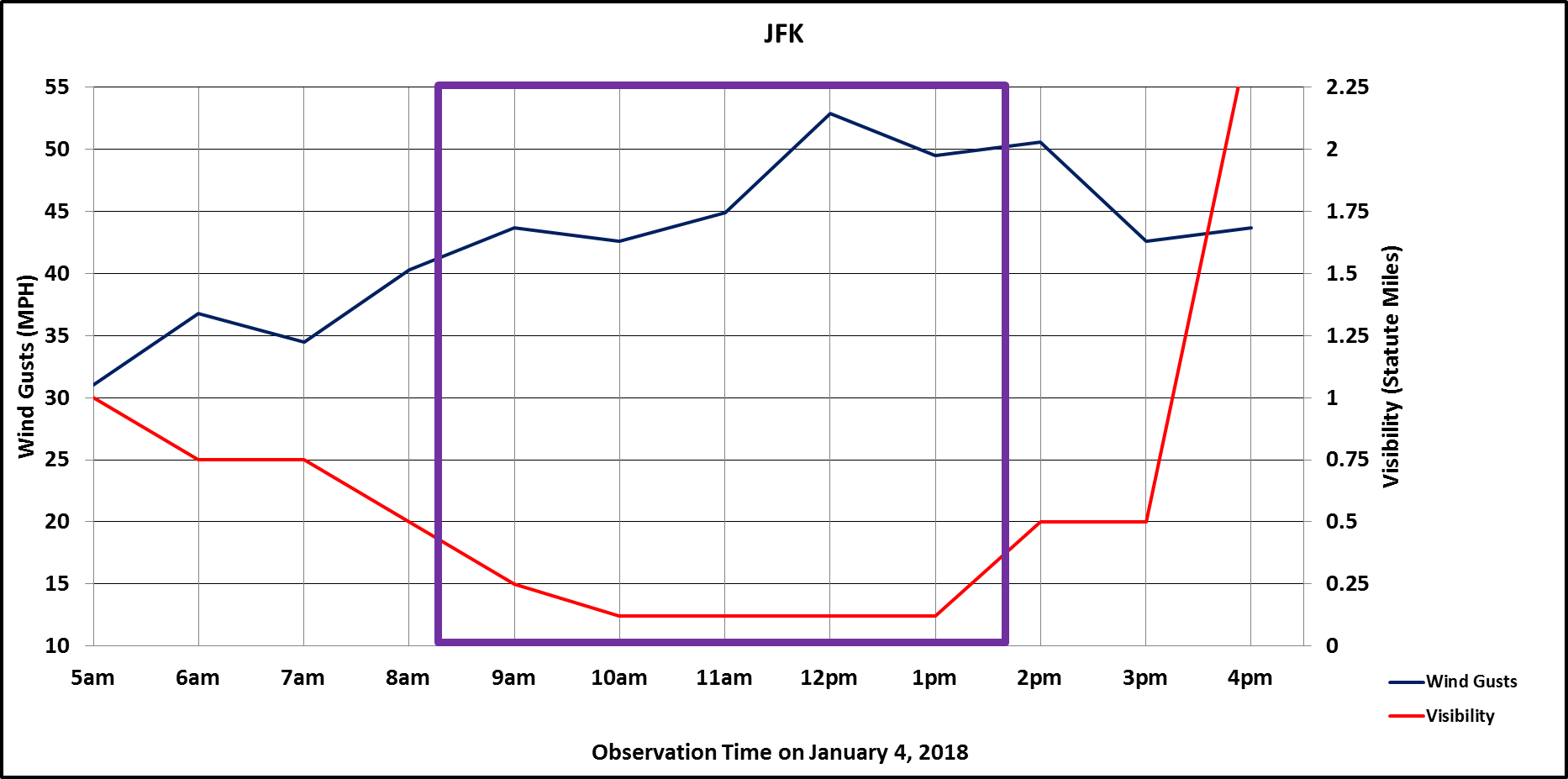
At Kennedy International Airport, Blizzard criteria were reported 
from 810 AM to 143 PM EST. 

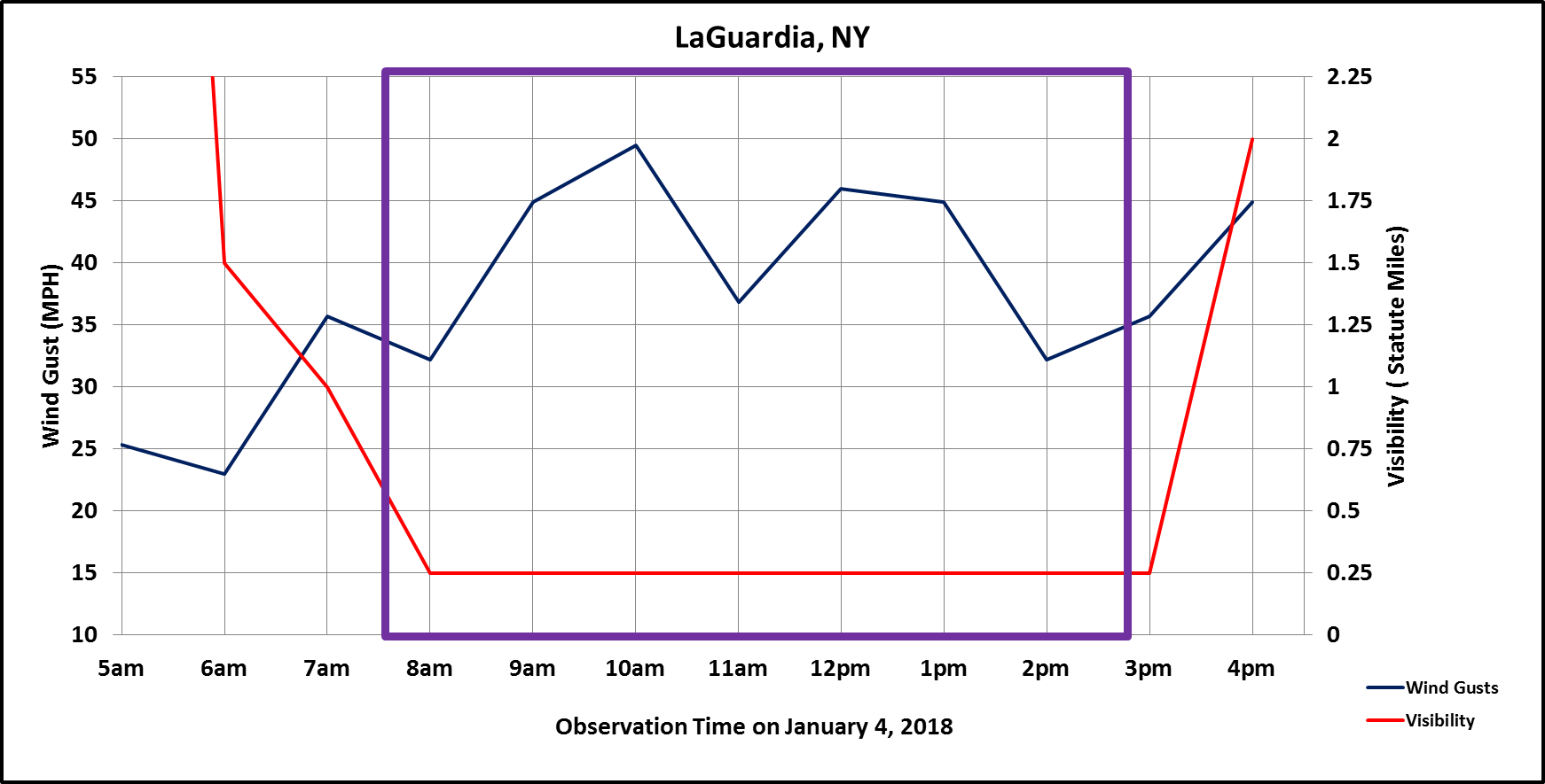
At La Guardia Airport, Blizzard criteria were reported from 751 AM 
to 251 PM EST. 

At Long Island MacArthur Airport (Islip, NY), blizzard criteria 
were reported from 756 AM to 140 PM and 326 PM to 456 PM EST. 

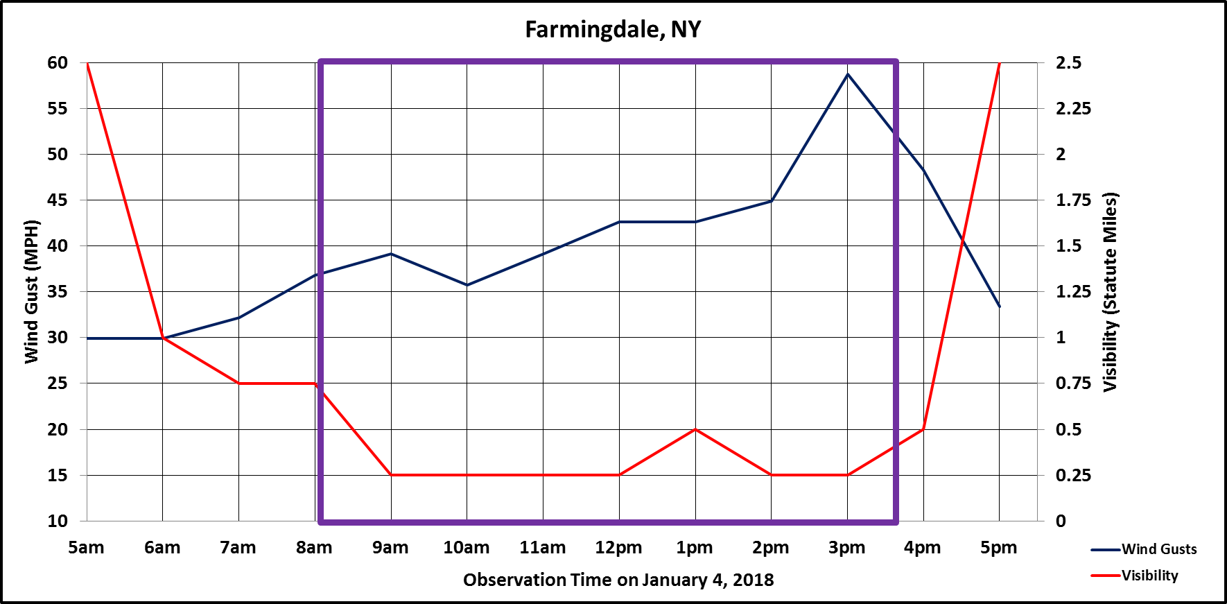
At Republic Airport (Farmingdale, NY), blizzard criteria were 
reported from 806 AM to 331 PM EST. The present weather sensor 
failed, but snow was verified by radar. 

At Brookhaven Airport (Shirley, NY), blizzard criteria were reported 
from 856 AM to 1156 AM EST. The present weather sensor failed, but 
snow was verified by radar. 

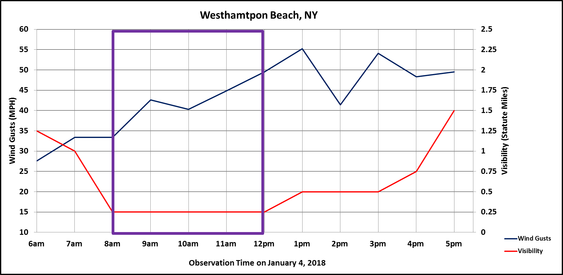
At Francis S Gabreski Airport (Westhampton Beach, NY), blizzard 
criteria were reported from 848 AM to 1153 AM EST. The present 
weather sensor failed, but snow was verified by radar. 

At Westchester County Airport (White Plains, NY), blizzard criteria 
were reported from 856 AM to 256 PM EST. 

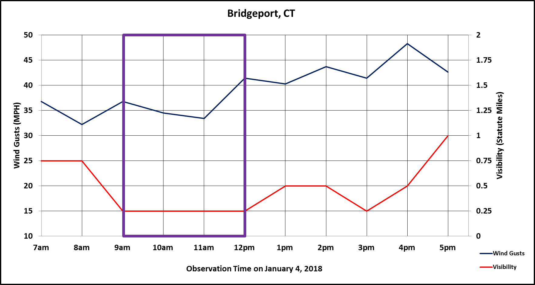
At Igor I Sikorsky Memorial Airport (Bridgeport, CT), blizzard 
criteria were reported from 852 AM to 1232 PM EST. The present 
weather sensor failed, but snow was verified by radar. 

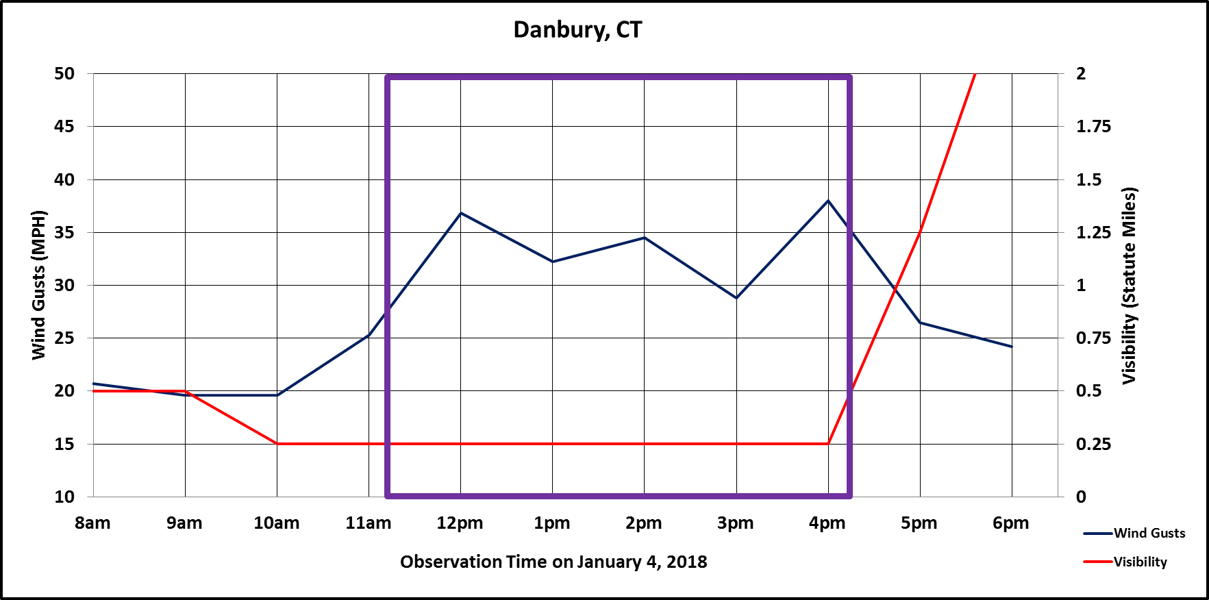
At Danbury Municipal Airport (Danbury, CT), blizzard criteria were 
reported from 1053 AM to 353 PM EST. The present weather sensor 
failed, but snow was verified by radar. 

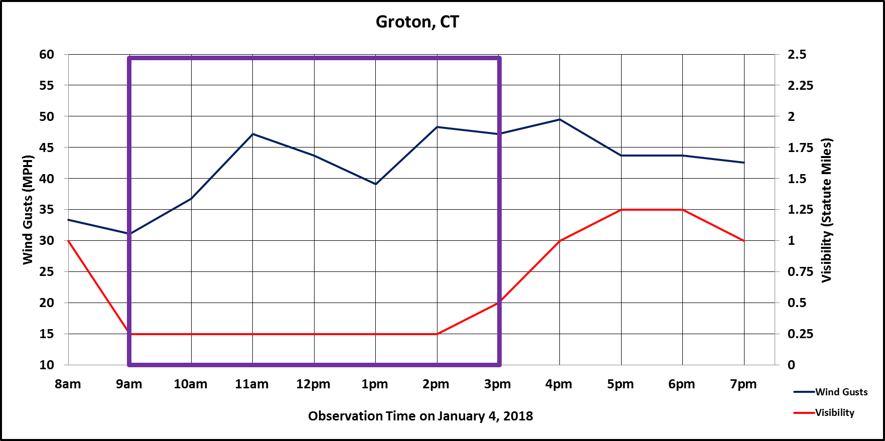
At Groton-New London Airport (Groton, CT), blizzard criteria were 
reported from 826 AM to 256 PM EST. The present weather sensor 
failed, but snow was verified by radar. 

Elsewhere across the Tri-State, near-blizzard conditions occurred at 
Central Park, NY, Newark Liberty International Airport (Newark, NJ), 
Teterboro Airport (Teterboro, NJ), Tweed New Haven Airport (New 
Haven, CT), and Meriden Markham Municipal Airport (Meriden, CT). 
These locations failed to meet the length of time criteria for winds 
and/or visibilities.   
                                          
   
Additional NWS Products
 

National Weather Service WFO New York, NY Watches, Warnings, and Advisories

The following links show each Blizzard, Blizzard Warning, Winter Storm Watch, Winter Storm Warning, and Special Weather Statements issued during this winter storm. The first Winter Strom Watch was issued at 11:43 am Tuesday, January 2, 2018. The first Winter Storm Warning was issued at 3:42 am Wednesday, January 3, 2018. First Blizzard Warnings were issued at 3:20 pm Wednesday, January 3, 2018  

  1. Blizzard:
  2. Winter Storm:
  3. Special Weather Statements