 |
 |
 |
 |
The National Weather Service's Doppler radar, known as NEXRAD (for the NEXt generation of RADar), is the only Doppler weather radar on Long Island. News agencies, television stations, military installations and other sites have access to the radar images through cooperation with the National Weather Service. In this way, the radar images can be shared with all interested groups.
Within the National Weather Service, NEXRAD is officially called the WSR-88D. The term WSR-88D is simple to explain: WSR stands for Weather Surveillance Radar; 88 represents the year the first NEXRAD was commissioned for use (1988); and the D means it is a Doppler radar.
Radar requires three integral parts to work: (1) an antenna/receiver, (2) computers that process the raw radar data, and (3) an interactive workstation that the forecasters can use to display the processed radar data.
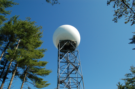
In a basic way, radar works like sonar. It all starts at the Radar Data Acquisition unit (RDA), which is the tower (pictured above) located adjacent to the forecast office. The radar dish (pictured above) is protected by a covering that resembles a giant soccer ball. The transmitter at the antenna within this protective dome sends out a pulse of energy. When this energy hits an object, like a raindrop or snowflake, it is reflected in all directions. Part of the energy will be reflected back to the antenna, where the dish focuses the returned energy.
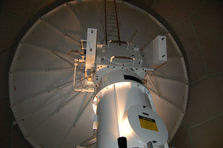
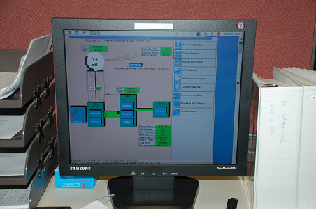
The returned energy, called base data, is sent from the RDA site to the processing computer located here in the office(bottom picture). The processing computer, known as the Radar Product Generator (RPG), performs various data quality checks of the raw radar data and creates radar images and products. The Advanced Weather Interactive Processing System (AWIPS) workstation, allows forecasters to display radar data(top picture).
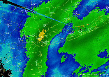
There are many types of radar images. The most common is a reflectivity image, which shows the areal extent of precipitation. Unfortunately, the radar can display "echoes" that may or may not represent meteorological targets. The radar is so sensitive that it can detect clouds, dust and aerosol particles, insects, and birds, not to mention airplanes and ground based objects near the RDA itself. In addition, radar alone cannot determine if precipitation is rain or snow. Forecasters use other information at their disposal to make this determination.
NEXRAD determines the movement of wind-driven precipitation using a principle known as the "Doppler effect". The Doppler effect is the alteration of the frequency of the radar-transmitted pulse of energy at the moment it is reflected off of a moving target (precipitation). If wind is moving precipitation toward the radar, the frequency of reflected energy picked up by NEXRAD increases. If the wind is moving precipitation away, the frequency of reflected energy decreases. The speed is determined by the amount of this frequency shift. The sophisticated computers within NEXRAD analyze these frequency shifts which can then be displayed as color imagery on the AWIPS workstation.
The reflectivity and velocity data from the WSR-88D are the primary data sources that National Weather Service meteorologists use to issue short-fused warnings for tornadoes, severe thunderstorms, and flash floods.


|
|
|
|
|
|
|
|
|
|
|
|
|
|


 Coastal Flooding