New York, NY National Weather Service
Marine Zone Expansion to 60 NM Offshore
OVERVIEW
Beginning on or about April 16, 2026, National Weather Service (NWS) Weather Forecast Office (WFO) New York, NY (OKX) will assume forecast, watch, and warning responsibility for the coastal waters from south of Sandy Hook NJ to Montauk Point NY from 20 to 60 Nautical Miles (NM) offshore. Routine forecast services for these waters were previously the responsibility of the Ocean Prediction Center (OPC), with warning responsibility divided between WFO OKX and OPC. This change is part of a regional improvement that will result in all forecasts and warnings for coastal waterways within 60 NM of shore originating from the local WFO across the entire Contiguous United States (CONUS). There will be no change to the current forecast and warning services provided by WFO OKX for coastal waterways within 20 NM of shore.
JUSTIFICATION
Within the marine forecast zones of the New York, NY WFO exists several ports, marinas, harbors, and more. It's home to the largest port on the east coast the Port of New York & New Jersey, third largest in the nation. The activities from mariners primarily take place within 60 NM of shore, with our marine partners depending on reliable weather forecasts from the National Weather Service to ensure the safety of themselves and their crew, passengers, and cargo while on the water. Routine forecast services for these waters were previously the responsibility of the Ocean Prediction Center (OPC), with warning responsibility divided between WFO OKX and OPC. Now, the forecast and warning responsibilities within 60 NM of the coast have been transferred to WFO OKX in order to improve forecast continuity and grow relationships between the office and our partners.

This graphic shows vessel transit counts from 2024. With WFO OKX extending the coastal waters to 60 NM there will be better coverage of marine traffic.
The coastal waterways are lifelines of commerce in northern New England, frequented by commercial, recreational, and research vessels year-round. Additionally, fishermen often leave local ports bound for offshore fishing sites. These activities primarily take place within 60 NM of shore, with mariners depending on reliable weather forecasts from the National Weather Service to ensure the safety of themselves and their crew, passengers, and cargo while on the water.
With the redesignation of all forecast and warning responsibility for the coastal waters within 60 NM of shore to the local WFO, users will experience these benefits:
Improved forecast service continuity, with local WFO’s now responsible for issuing routine forecasts and warnings for all marine waters out to 60 NM offshore for the entire CONUS.
Increased number of forecast parameters with temperature, precipitation chances, and weather type among the parameters that are now available for mariners from 20 to 60 NM offshore out to 5 days in the future.
Improved forecast resolution, with point and click forecast capability now enabling mariners to get precise hourly forecasts for specific points (specific fishing location) anywhere within 60 NM of shore out to 5 days in the future.
Expanded suite of short and long-fused watch & warning products to alert mariners to the potential for a variety of hazardous weather conditions.
WFO’s now have the capability to deliver Impact-based Decision Support Services (IDSS) to partners in support of incident response for incidents that occur anywhere within 60 NM of shore. This includes SPOT weather forecasts for ongoing marine incidents.
ZONE CHANGE DESCRIPTION
The areal extent of the new marine zones was largely established by maintaining the current location and orientation of the along-coast zone breaks for the nearshore marine zones and extending them to meet a line which runs approximately 60 NM off the coast. The following graphics and table illustrate the new area covered by these zones.
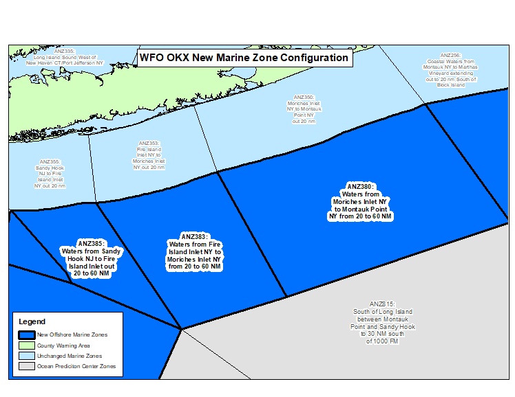
The above graphic shows the new alignment of marine forecast zones with light and dark blue zones now being the responsibility of the local WFO. All coastal waters to 60 NM offshore south of Sandy Hook NJ to Montauk Point NY will now receive forecasts and warnings from NWS OKX.
| Area | Previous Zone Name | Previous Zone Number | New Zone Name | New Zone Number |
| Waters from Sandy Hook NJ to Fire Island Inlet NY out 20 to 40 NM | Waters from Sandy Hook NJ to Fire Island Inlet NY out 20 to 40 NM | ANZ375 | Waters from Sandy Hook NJ to Fire Island Inlet NY from 20 to 60 NM | ANZ385 |
| Waters from Fire Island Inlet NY to Moriches Inlet NY from 20 to 40 NM | Waters from Fire Island Inlet NY to Moriches Inlet NY from 20 to 40 NM | ANZ373 | Waters from Fire Island Inlet NY to Moriches Inlet NY from 20 to 60 NM | ANZ383 |
| Waters from Moriches Inlet NY to Montauk Point NY from 20 to 40 NM | Waters from Moriches Inlet NY to Montauk Point NY from 20 to 40 NM | ANZ370 | Waters from Moriches Inlet NY to Montauk Point NY from 20 to 60 NM | ANZ380 |
FORECAST RESOURCES
| Product Name | WMO Header | AWIPS ID |
| Coastal Waters Forecast | FZUS51 | CWFOKX |
| Marine Weather Message | WHUS71 | MWWOKX |
| Special Marine Warning | WHUS51 | SMWOKX |
| Marine Weather Statement | FZUS71 | MWSOKX |
| Watch County Notification | WWUS61 | WCNOKX |
Marine users have several options for directly receiving official National Weather Service forecasts and warnings:
One of the most immediate and reliable ways to receive forecasts, watches, and warnings for the Gulf of Maine is through NOAA Weather Radio. The following table and map outline the best transmitter for coastal water areas:

Routine forecasts and warnings for mariners in New Jersey and Delaware waters can be found online at weather.gov/okx/marine.
Alternatively, to get the forecast for a specific point, visit weather.gov/marine/point and click on the map or enter you lat/lon.
For more information, please contact:
okx.webmaster@noaa.gov
NWS National Service Change Notices are online at: https://www.weather.gov/notification/


 Coastal Flooding