Top 10 Weather Headlines of 2003
The 2003 spring severe weather season produced a record number of tornadoes. After going 10 years without a tornado fatality from 1991 to 2001, the year 2003 was the second consecutive year with at least one killer tornado. The tornado count for 2003 was unprecedented: a record 39 tornadoes occurred in the 58 counties currently served by the Paducah office, breaking the record of 37 set in 1957.
The winter season of 2002-03 was the snowiest since 1984-85 at Paducah. The cold and snowy pattern of the winter of 2002-03 occurred after a string of unusually mild winters that began in the mid 1990's.
The following events are ranked in the order of their overall impact on society. This is an estimate based on both severity of the event and number of people impacted by the event. The severity is determined by fatalities, injuries, and damage, if any. For winter storms, the severity is based on precipitation amounts and their effects. These effects are obtained from newspaper reports, spotters, and any other available sources.
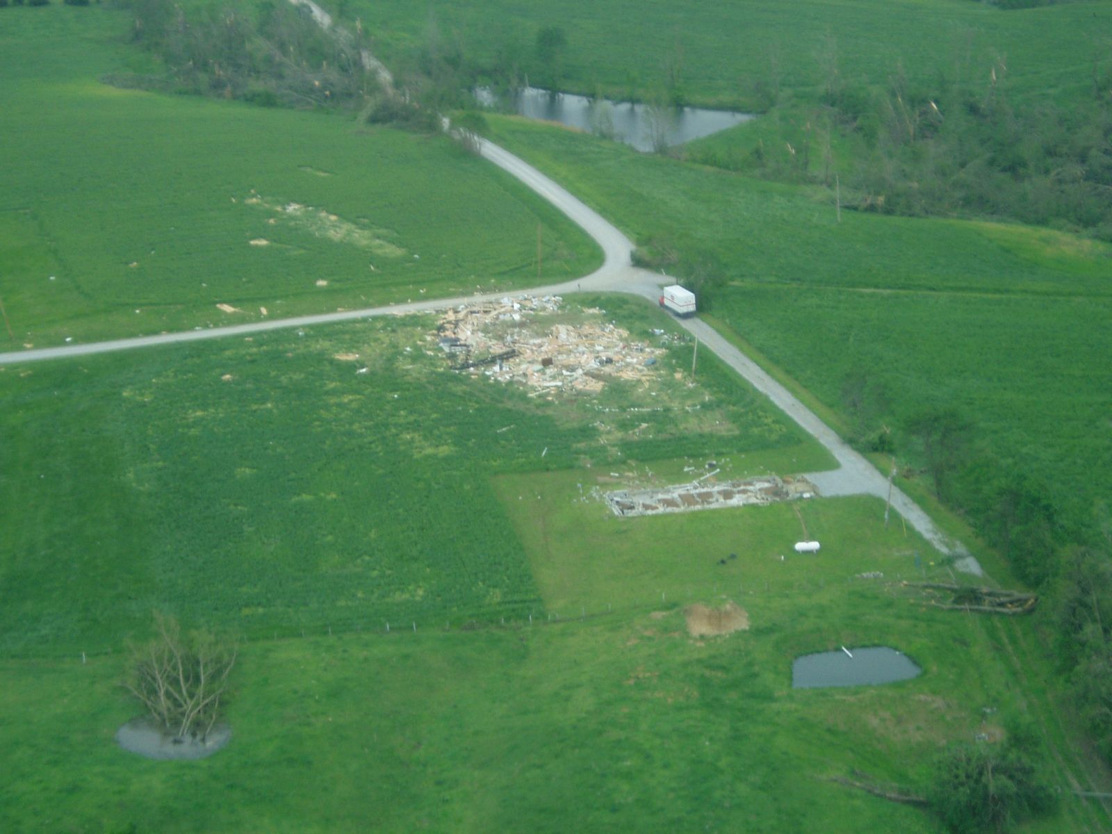 1. May 6 Tornadoes - Two persons were killed in an F-4 tornado that tracked 33 miles across extreme southern Illinois. This long-track tornado injured close to 40 people and damaged or destroyed a few hundred homes. Near Cape Girardeau, Missouri, the city of Jackson was struck directly by an F-3 tornado that caused well over 10 million dollars in damage. However, no deaths or serious injuries occurred there. A total of 21 tornadoes occurred in the Paducah County Warning Area that evening. (NWS Photo, Massac County, IL). 1. May 6 Tornadoes - Two persons were killed in an F-4 tornado that tracked 33 miles across extreme southern Illinois. This long-track tornado injured close to 40 people and damaged or destroyed a few hundred homes. Near Cape Girardeau, Missouri, the city of Jackson was struck directly by an F-3 tornado that caused well over 10 million dollars in damage. However, no deaths or serious injuries occurred there. A total of 21 tornadoes occurred in the Paducah County Warning Area that evening. (NWS Photo, Massac County, IL). |
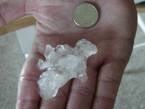
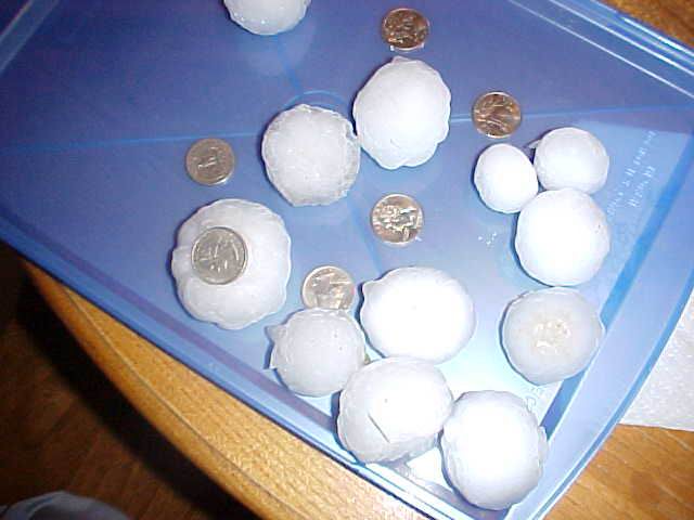 2 . May 4 Hailstorms - Tens of millions of dollars in damage were caused by destructive hailstorms in western Kentucky. The Paducah area, including Marshall County, suffered the brunt of the damage. Thousands of vehicles and houses were damaged by the hail, which was as large as baseballs. One person was cut and bruised by hailstones in Paducah. This was the first time someone was reported to have been injured by hail in our area since at least 1994. Photo from Calvert City, KY. 2 . May 4 Hailstorms - Tens of millions of dollars in damage were caused by destructive hailstorms in western Kentucky. The Paducah area, including Marshall County, suffered the brunt of the damage. Thousands of vehicles and houses were damaged by the hail, which was as large as baseballs. One person was cut and bruised by hailstones in Paducah. This was the first time someone was reported to have been injured by hail in our area since at least 1994. Photo from Calvert City, KY. |
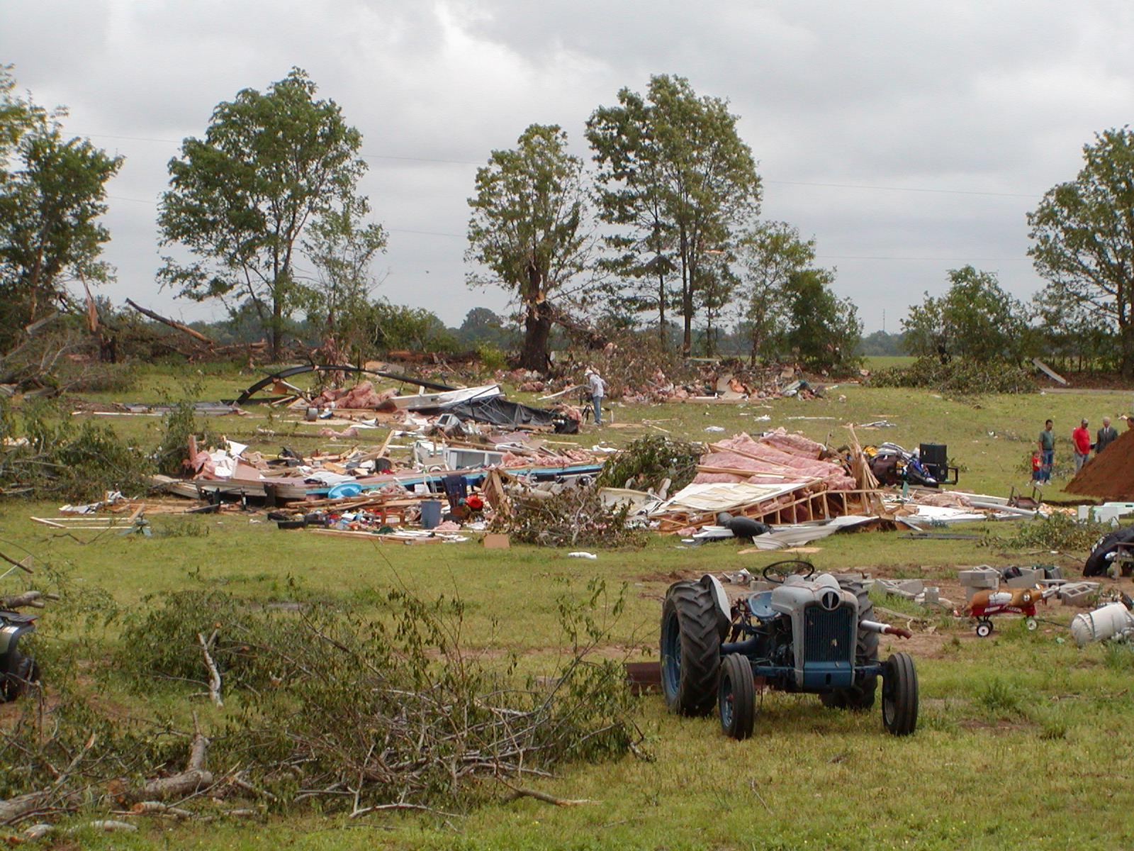 3. May 4 Tornadoes - Several hours after the destructive hailstorms in western Kentucky, a dozen tornadoes occurred. Several of these tornadoes reached F-2 intensity. Total damage figures were around 2 million dollars. The town of Clay in Webster County, KY was especially hard hit. Four injuries were reported, none of which were life-threatening. (NWS Photo, Scott County, MO). 3. May 4 Tornadoes - Several hours after the destructive hailstorms in western Kentucky, a dozen tornadoes occurred. Several of these tornadoes reached F-2 intensity. Total damage figures were around 2 million dollars. The town of Clay in Webster County, KY was especially hard hit. Four injuries were reported, none of which were life-threatening. (NWS Photo, Scott County, MO). |
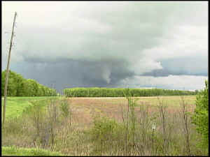
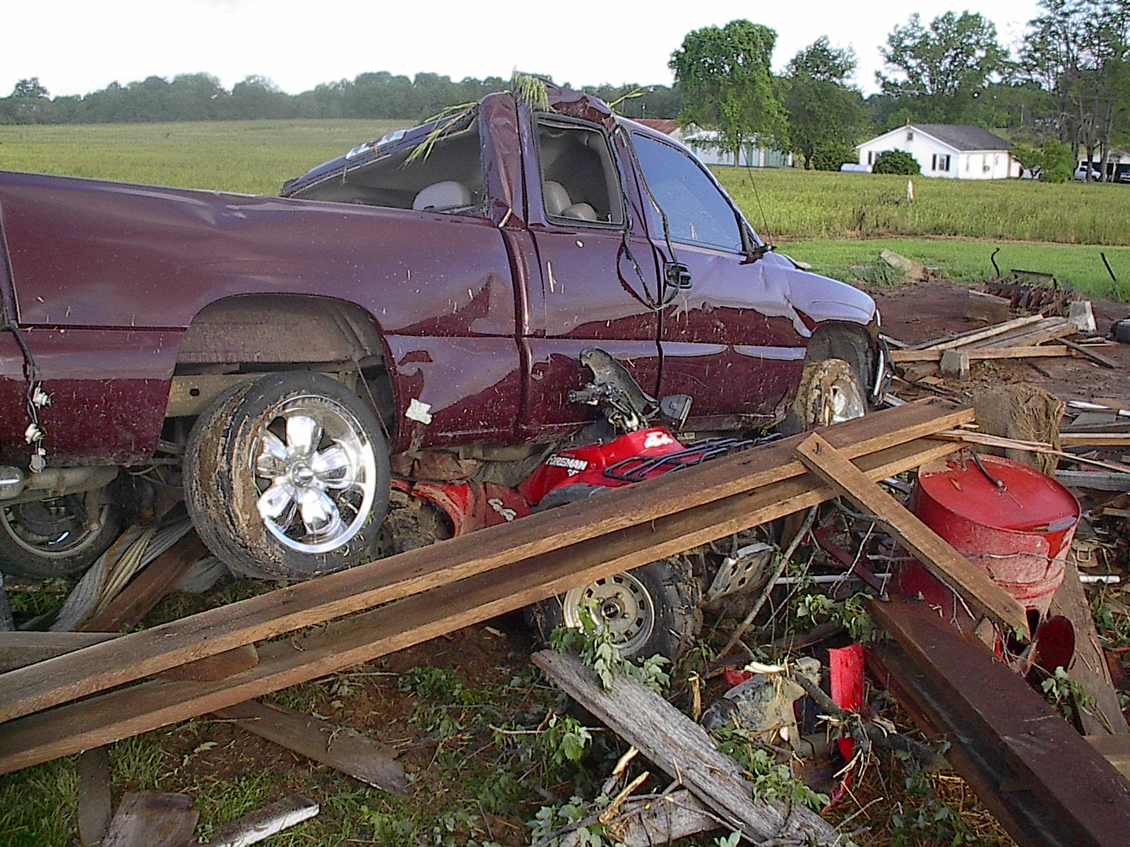 4. May 11 Tornado in Sacramento, KY - An F-3 tornado struck the Mclean County town of Sacramento, causing two minor injuries and almost a half million dollars damage. The tornado occurred during the pre-dawn hours. (NWS Photo) 4. May 11 Tornado in Sacramento, KY - An F-3 tornado struck the Mclean County town of Sacramento, causing two minor injuries and almost a half million dollars damage. The tornado occurred during the pre-dawn hours. (NWS Photo) |
 5. Presidents Day Weekend Sleet Storm - Several inches of sleet, mixed with snow and freezing rain, fell in the Evansville Tri-State Region and much of southern Illinois on Feb. 15 and 16. Major travel difficulties were reported as the sleet compacted into a layer of ice on many highways. Photo from Norm Bredenkamp, Grayville, IL. 5. Presidents Day Weekend Sleet Storm - Several inches of sleet, mixed with snow and freezing rain, fell in the Evansville Tri-State Region and much of southern Illinois on Feb. 15 and 16. Major travel difficulties were reported as the sleet compacted into a layer of ice on many highways. Photo from Norm Bredenkamp, Grayville, IL. |
 6. April 20 Severe Storms and Crofton Tornado - Scattered severe thunderstorms crossed Western Kentucky and Southwest Indiana, producing large hail up to 2 inches in diameter. The town of Crofton, Kentucky in Christian County was particularly hard hit by downburst winds and an embedded F-1 tornado. Owensboro, KY reported hailstones up to 2 inches in diameter. Photo from Shawn Dunnaway, Murray, KY. 6. April 20 Severe Storms and Crofton Tornado - Scattered severe thunderstorms crossed Western Kentucky and Southwest Indiana, producing large hail up to 2 inches in diameter. The town of Crofton, Kentucky in Christian County was particularly hard hit by downburst winds and an embedded F-1 tornado. Owensboro, KY reported hailstones up to 2 inches in diameter. Photo from Shawn Dunnaway, Murray, KY. |
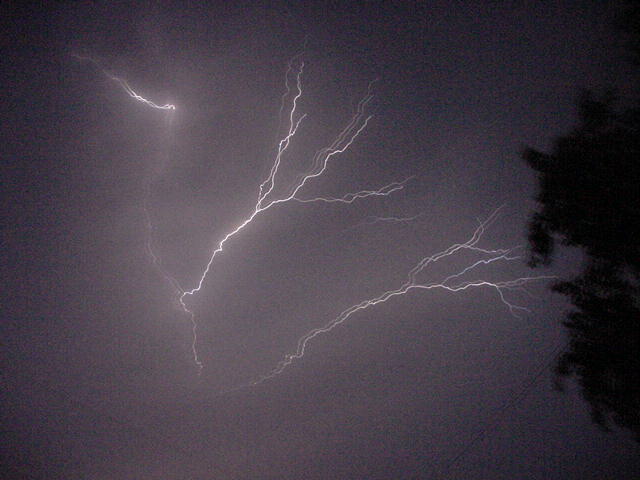
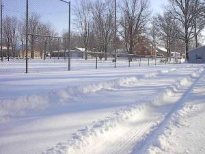 7. February 23-24 Heavy Snow - Four to eight inches of snow blanketed areas north of a line from Cape Girardeau, MO to Evansville, IN. The snow fell heavily, with thunder and lightning at times. Photo from Charlie Kiesel, Fort Branch, IN. 7. February 23-24 Heavy Snow - Four to eight inches of snow blanketed areas north of a line from Cape Girardeau, MO to Evansville, IN. The snow fell heavily, with thunder and lightning at times. Photo from Charlie Kiesel, Fort Branch, IN. |
 8. July 28 Severe Thunderstorms - Widely scattered storms formed during the heat of the day and became severe over western KY and southeast MO. A motorist was injured in downtown Paducah when a roof became airborne and struck his car. Hail up to golf-ball size occurred in the Doniphan and Poplar Bluff, MO areas. (Photo taken by Mike Holland). 8. July 28 Severe Thunderstorms - Widely scattered storms formed during the heat of the day and became severe over western KY and southeast MO. A motorist was injured in downtown Paducah when a roof became airborne and struck his car. Hail up to golf-ball size occurred in the Doniphan and Poplar Bluff, MO areas. (Photo taken by Mike Holland). |
 9. Hail and Weak Tornadoes on April 25 - Two short-lived tornadoes occurred during the afternoon: one in a forest about 10 miles north of Cairo, IL and another near Calvert City, KY. The F-1 tornado near Calvert City caused some damage to mobile homes and outbuildings. During the previous evening, large hail fell at Sesser and Mount Vernon, IL. Photo courtesy of KFVS television, taken from IL Route 3. 9. Hail and Weak Tornadoes on April 25 - Two short-lived tornadoes occurred during the afternoon: one in a forest about 10 miles north of Cairo, IL and another near Calvert City, KY. The F-1 tornado near Calvert City caused some damage to mobile homes and outbuildings. During the previous evening, large hail fell at Sesser and Mount Vernon, IL. Photo courtesy of KFVS television, taken from IL Route 3. |
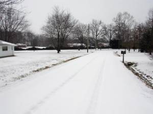
 10. Snowstorm on January 16 - Three to four inches of snow blanketed much of southeast Missouri and western Kentucky during the morning of January 16. The timing of the heavy snow coincided with the morning drive-time, prompting many school closings. (NWS Photo) 10. Snowstorm on January 16 - Three to four inches of snow blanketed much of southeast Missouri and western Kentucky during the morning of January 16. The timing of the heavy snow coincided with the morning drive-time, prompting many school closings. (NWS Photo) |
|
Have a safe and happy 2004! |

