Top Weather Headlines of 2010
Severe weather outbreaks were few and far between in 2010. The annual total of severe weather events for 2010 was the lowest since the modernized National Weather Service office in Paducah was opened in 1994.
|
Jan. and Feb. Cold - The year started with a prolonged period of very cold temperatures. The winter of 2009-10 was the coldest since the winters of the late 1970's and early 80's. Paducah experienced its 6th coldest winter. One of the ten longest streaks of sub-freezing temperatures was recorded at Evansville and Paducah in January. |
| Jan. 29-30 Snowstorm - In many places, the Jan. 29-30 snowstorm was the biggest since the record pre-Christmas snowstorm in 2004. A total of 4 to 10 inches fell south of Interstate 64. View snowfall map and statistics. |
|
Feb. 8-9 Snowstorm - Four to seven inches of snow blanketed most of western Kentucky and southwest Indiana. View snowfall map and statistics. |
|
Valentine's Night Snowstorm - Southwest Indiana and the Wabash Valley bore the brunt of this snowstorm that dumped 6 to 8 inches there. Strong winds piled drifts over two feet deep in open country. View snowfall map and statistics. |
|
|
|
|
|
|
|
June 15 Severe Weather - This was one of the most widespread severe weather outbreaks of the year. An example of the wind damage in Princeton, IN is shown to the left. View preliminary listing of storm reports. |
|
Summer Heat - This was the hottest summer since the Dust Bowl years of the 1930's at Evansville. The average temperature was tied for the hottest summer on record at Paducah and 3rd hottest summer at Evansville. View temperature statistics. |
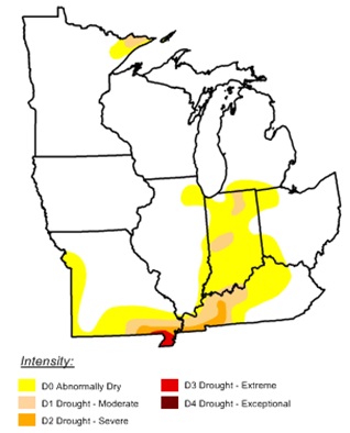 Severe Drought - Severe drought developed during the summer and peaked during early fall. Most of southeast Missouri and western Kentucky received federal disaster declarations due to major crop damage. Severe drought lingered through the remainder of the year in parts of western Kentucky and southeast Missouri. |
|
Have a safe and happy 2011! |