Top 10 Weather Headlines of 2011
On both a national and a local scale, extreme weather events in 2011 captured our attention. A record-breaking spring flood season dominated the weather news for weeks. Flooding on the Mississippi and Ohio Rivers brought national attention to our region. Record high water levels were observed at several locations on area rivers and lakes. The annual rainfall totals at Paducah and Evansville were the highest on record.
-
The winter of 2010-11 was unusually snowy, especially across western Kentucky. The seasonal snowfall total at Paducah was 18.9 inches, which was the 8th highest on record. The meteorological winter (Dec. 1-Feb. 28) was the 15th coldest on record at Paducah.
- The spring severe weather season was very active. The annual tornado count for the Paducah NWS forecast area was the highest since the modernized office opened in 1994. The total number of severe weather events (hail, tornadoes, and damaging winds) was second only to 2006. A table of severe weather stats for 2011 and the past 15 years shows the numbers.
- The following weather events are ranked unscientifically. The primary rating factors are economic impact, fatalities and injuries, and social impact. The meteorological significance of the event is secondary.
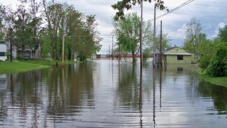 1. Late April / Early May Flooding 1. Late April / Early May Flooding - The wettest spring on record at Paducah, KY contributed to record flooding along parts of the Ohio and Mississippi Rivers, as well as Kentucky Lake and Lake Barkley. The economic impact on our local area was in the hundreds of millions of dollars. The New Madrid Floodway was activated by detonating portions of a Mississippi River levee for the first time since 1937. Fortunately, there was not one injury or fatality directly attributable to the flooding. (Photo taken in Metropolis, IL near the Ohio River.) |
|
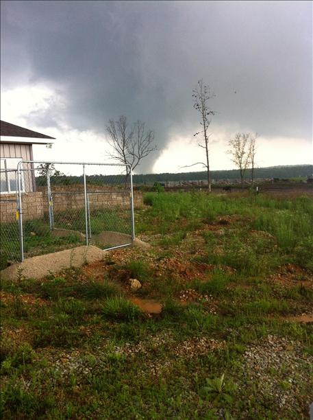 2. May 25 Severe Weather Outbreak - What began as an outbreak of supercells and tornadoes in southeast Missouri gradually evolved into a line of storms with widespread damaging winds and embedded tornadoes. An EF-3 tornado that passed through the Ozark Mountain foothills of Carter and Wayne Counties produced a total damage track about 48 miles long. Widespread damaging winds from 60 to 75 mph occurred across western Kentucky, southern Illinois, and southwest Indiana. There were a few injuries and no fatalities. (Photo taken at Ellsinore, MO courtesy of Janet Leach). 2. May 25 Severe Weather Outbreak - What began as an outbreak of supercells and tornadoes in southeast Missouri gradually evolved into a line of storms with widespread damaging winds and embedded tornadoes. An EF-3 tornado that passed through the Ozark Mountain foothills of Carter and Wayne Counties produced a total damage track about 48 miles long. Widespread damaging winds from 60 to 75 mph occurred across western Kentucky, southern Illinois, and southwest Indiana. There were a few injuries and no fatalities. (Photo taken at Ellsinore, MO courtesy of Janet Leach).
|
|
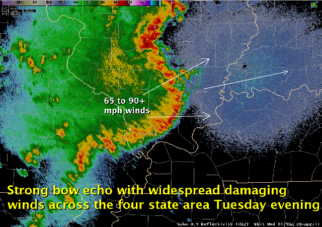 3. April 19 Bow Echo - Widespread wind gusts from 60 to 80 mph, with pockets of 90 to 100 mph winds, accompanied a bow echo during the evening of the 19th. Isolated EF-1 and EF-2 tornadoes occurred. Damage was in the millions of dollars across southern Illinois and southwest Indiana. In farm country of the Wabash Valley region, there was widespread damage to agricultural facilities such as grain bins and barns. (Radar image of bow echo across southern Illinois). 3. April 19 Bow Echo - Widespread wind gusts from 60 to 80 mph, with pockets of 90 to 100 mph winds, accompanied a bow echo during the evening of the 19th. Isolated EF-1 and EF-2 tornadoes occurred. Damage was in the millions of dollars across southern Illinois and southwest Indiana. In farm country of the Wabash Valley region, there was widespread damage to agricultural facilities such as grain bins and barns. (Radar image of bow echo across southern Illinois).
|
|
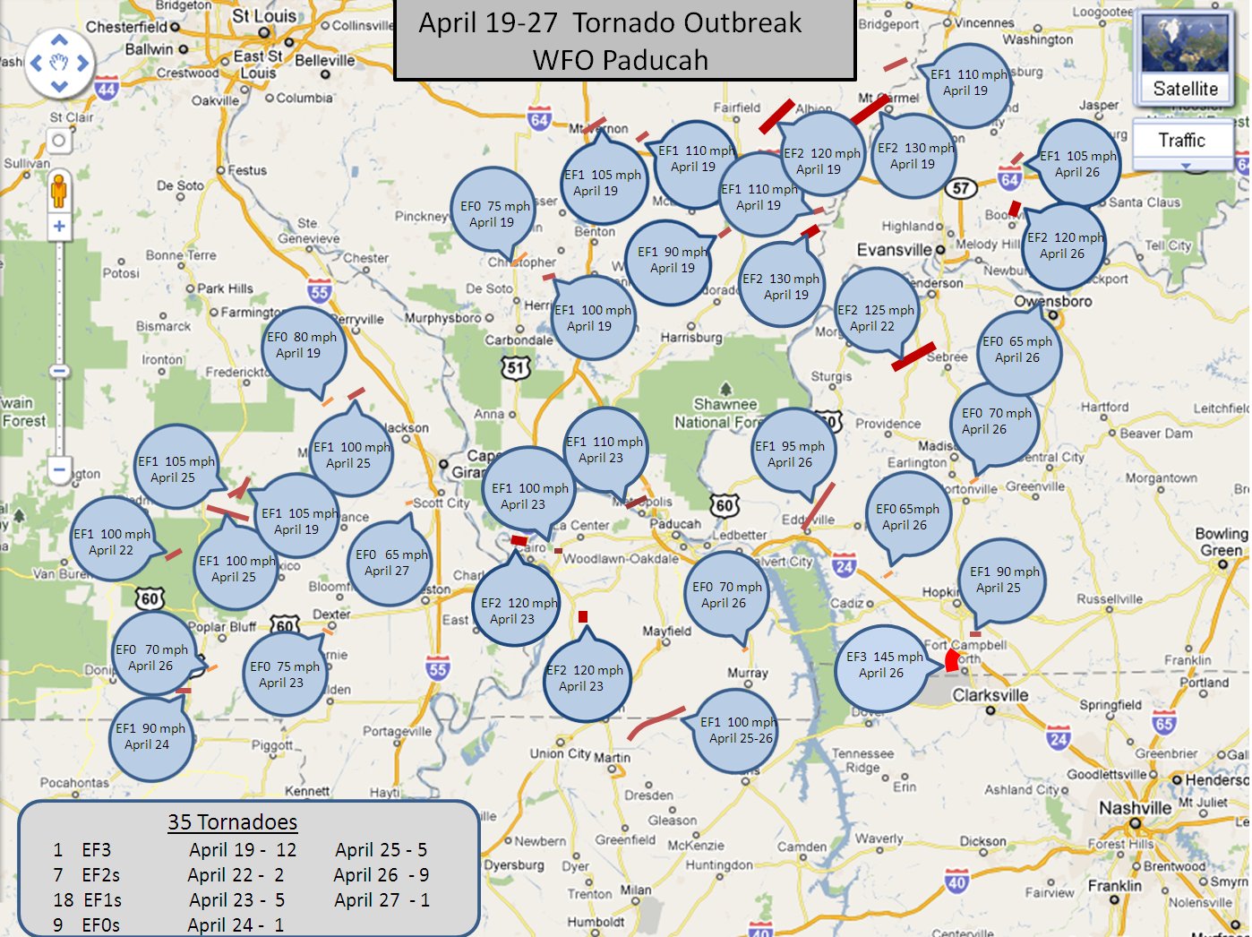 4. April 22-27 Severe Storm Outbreaks - Daily rounds of severe storms and flash flooding plagued our region for nearly a full week. There was at least one tornado each day for six consecutive days. About two dozen tornadoes occurred during this six-day stretch, including one EF-3 and several EF-2 tornadoes. Also see pages for April 22 event and April 26 event. (Tornado path map for 35 tornadoes April 19-27.) 4. April 22-27 Severe Storm Outbreaks - Daily rounds of severe storms and flash flooding plagued our region for nearly a full week. There was at least one tornado each day for six consecutive days. About two dozen tornadoes occurred during this six-day stretch, including one EF-3 and several EF-2 tornadoes. Also see pages for April 22 event and April 26 event. (Tornado path map for 35 tornadoes April 19-27.)
|
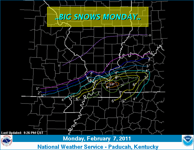 5. Feb. 7 Heavy Snow - Southwestern Kentucky was surprised by a blast of heavy snow that dumped 5 to 10 inches in the morning. A band of heavy snow produced snowfall rates from 2 to 3 inches per hour. The snow occurred during the peak travel time as commuters headed to work or school. Several school busses slid into ditches. (Snowfall map for the Feb. 7 storm). 5. Feb. 7 Heavy Snow - Southwestern Kentucky was surprised by a blast of heavy snow that dumped 5 to 10 inches in the morning. A band of heavy snow produced snowfall rates from 2 to 3 inches per hour. The snow occurred during the peak travel time as commuters headed to work or school. Several school busses slid into ditches. (Snowfall map for the Feb. 7 storm). |
|
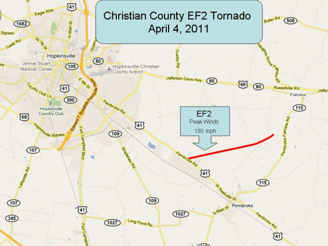 6. April 4 Tornadoes - An EF-2 tornado near Hopkinsville, KY received national media attention after striking a manufacturing plant and injuring about seven workers. A few other tornadoes occurred in western Kentucky, including one that injured a farm worker in Ballard County. (Tornado path map for the EF-2 tornado in Christian County). 6. April 4 Tornadoes - An EF-2 tornado near Hopkinsville, KY received national media attention after striking a manufacturing plant and injuring about seven workers. A few other tornadoes occurred in western Kentucky, including one that injured a farm worker in Ballard County. (Tornado path map for the EF-2 tornado in Christian County).
|
|
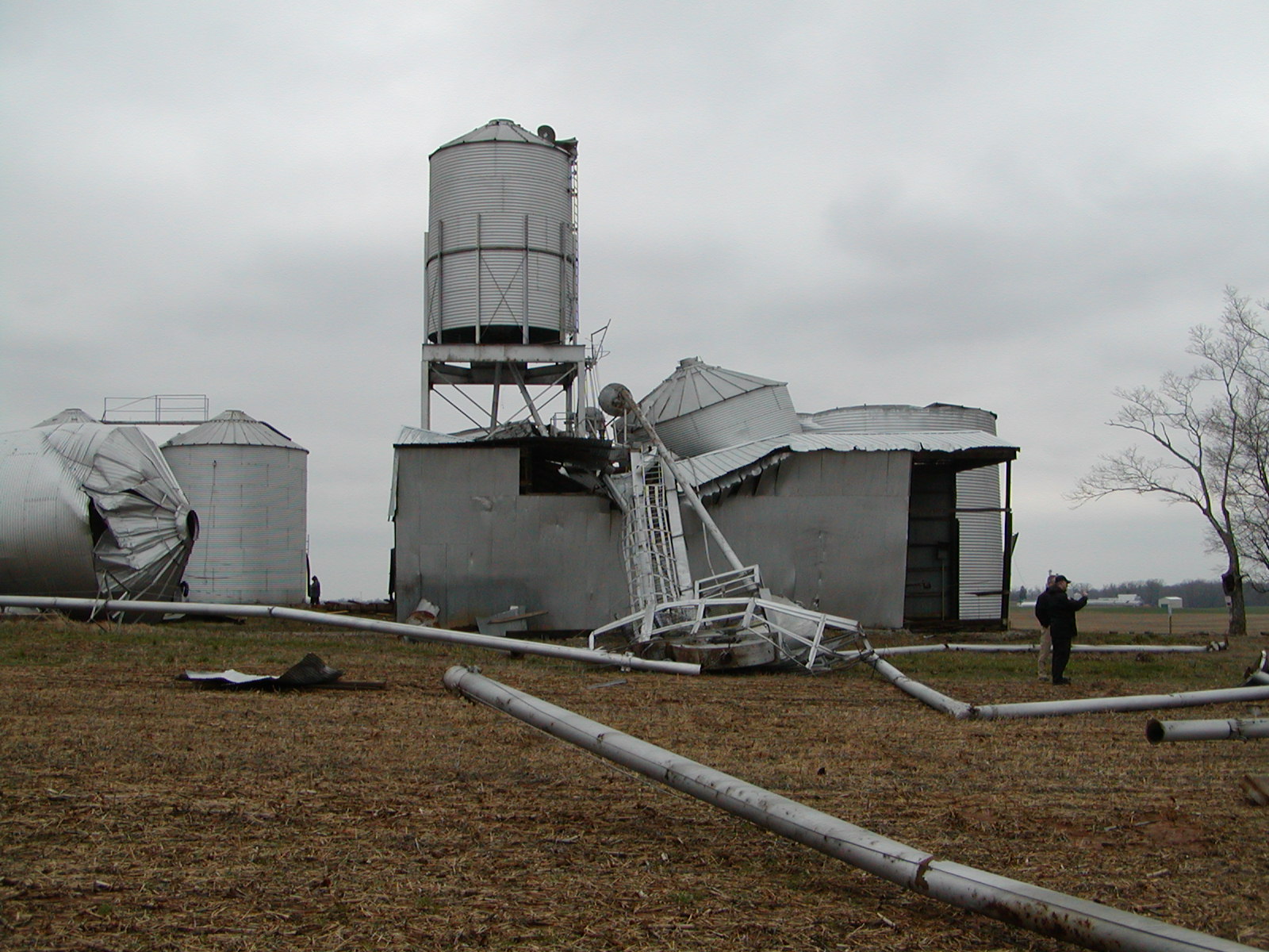 7. Feb. 24&27 Flooding/Severe Weather - Flooding was the main concern on Feb. 24, followed by a round of severe weather on Feb. 27. Over 3 inches of rain fell at Paducah on the 24th, setting a daily rainfall record. An Amish family suffered the tragic loss of four family members when their horse-drawn buggy was swept away at a flooded low-water crossing on the Graves/Hickman County line in Kentucky. On the 27th, the most significant damage was north of I-64 in southwest Indiana, where homes were damaged by an EF-2 tornado. See also tornado damage surveys for southwest Indiana. (Photo of grain bins damaged by EF-2 tornado in Christian County.) 7. Feb. 24&27 Flooding/Severe Weather - Flooding was the main concern on Feb. 24, followed by a round of severe weather on Feb. 27. Over 3 inches of rain fell at Paducah on the 24th, setting a daily rainfall record. An Amish family suffered the tragic loss of four family members when their horse-drawn buggy was swept away at a flooded low-water crossing on the Graves/Hickman County line in Kentucky. On the 27th, the most significant damage was north of I-64 in southwest Indiana, where homes were damaged by an EF-2 tornado. See also tornado damage surveys for southwest Indiana. (Photo of grain bins damaged by EF-2 tornado in Christian County.)
|
|
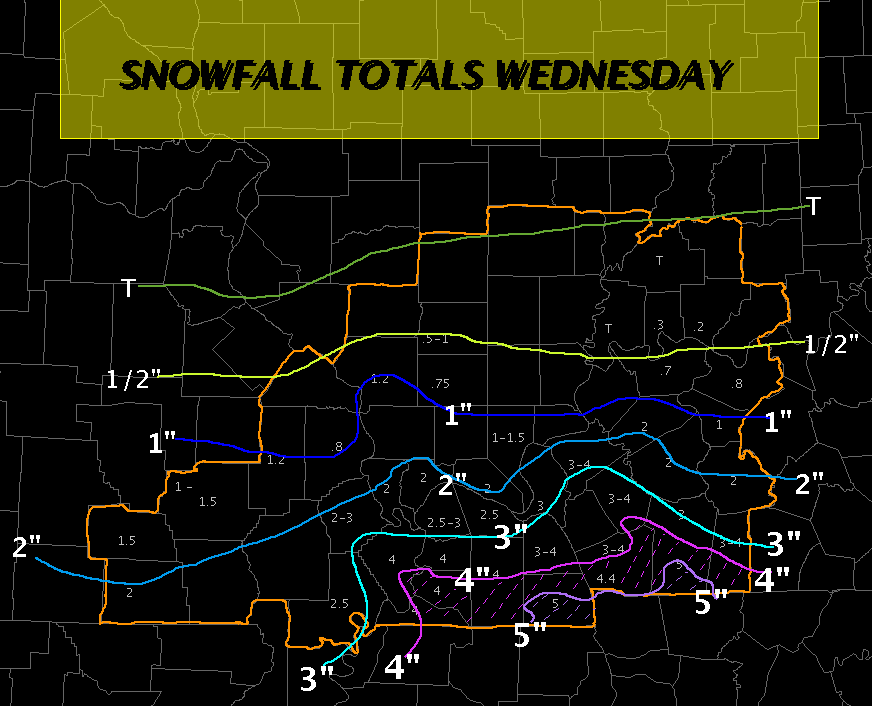 8. Jan. 25-26 Heavy Snow - A large part of western Kentucky received 3 to 6 inches of snow during the night of the 25th. Two heavy snow bands over the Pennyrile region produced at least one inch per hour. The morning commute was heavily impacted, and there were a couple of fatal accidents. (Snowfall map for the Jan. 25-26 storm). 8. Jan. 25-26 Heavy Snow - A large part of western Kentucky received 3 to 6 inches of snow during the night of the 25th. Two heavy snow bands over the Pennyrile region produced at least one inch per hour. The morning commute was heavily impacted, and there were a couple of fatal accidents. (Snowfall map for the Jan. 25-26 storm).
|
|
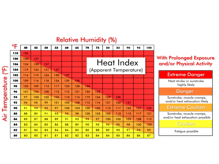 9. Aug. 3 Excessive Heat - Heat indices peaked between 112 and 126 degrees at airport observing sites during the afternoon of Aug. 3. This day was the worst of a 30-day stretch of hot and humid weather that resulted in two fatalities in southeast Missouri. July was the 5th hottest July on record at Paducah and Evansville. (NWS heat index chart). 9. Aug. 3 Excessive Heat - Heat indices peaked between 112 and 126 degrees at airport observing sites during the afternoon of Aug. 3. This day was the worst of a 30-day stretch of hot and humid weather that resulted in two fatalities in southeast Missouri. July was the 5th hottest July on record at Paducah and Evansville. (NWS heat index chart).
|
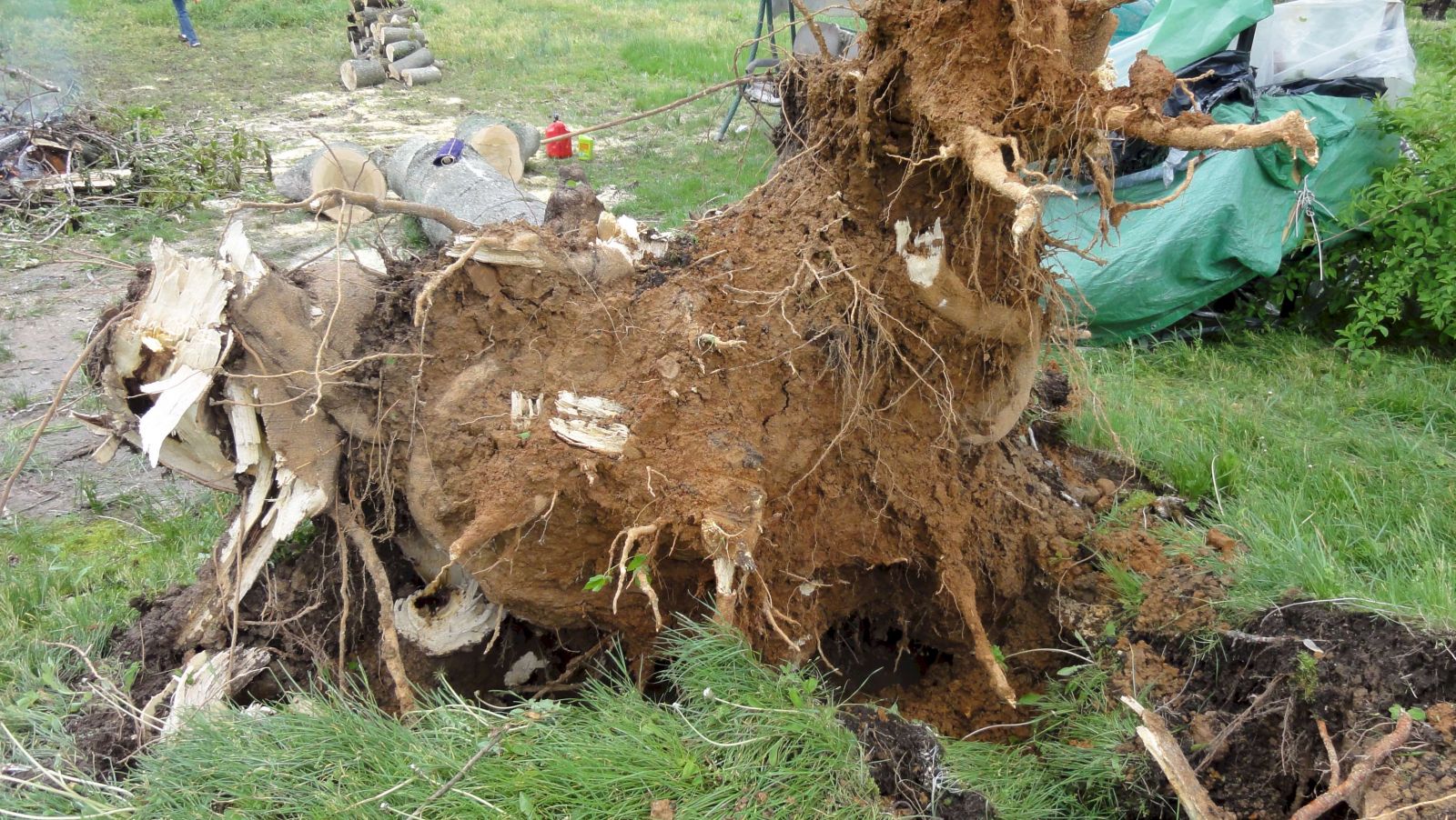 10. April 15 Severe Weather Outbreak - Large hail occurred in many places across southeast Missouri, southwest Illinois, and the Purchase area of western Kentucky. There were isolated damaging wind gusts, and even a couple of tornadoes in Trigg County, KY. The tornadoes were rated EF-0 and EF-1. Half-dollar size hail dented vehicles at the Paducah NWS office. (Photo of tree uprooted in Trigg County, KY). 10. April 15 Severe Weather Outbreak - Large hail occurred in many places across southeast Missouri, southwest Illinois, and the Purchase area of western Kentucky. There were isolated damaging wind gusts, and even a couple of tornadoes in Trigg County, KY. The tornadoes were rated EF-0 and EF-1. Half-dollar size hail dented vehicles at the Paducah NWS office. (Photo of tree uprooted in Trigg County, KY). |
|
Have a safe and happy 2012!
|

