March 28, 2022: Severe Straight Line Winds From Light Showers
Last updated 10:00 AM MST April 4th, 2022
|
|
|
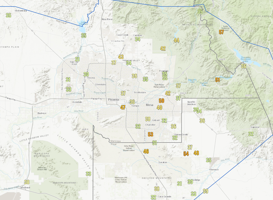
Fig. 1 - Max wind gusts equal to or greater than 30 mph through 7 PM MST on March 28th. |
Light showers in the afternoon of the 28th of March produced strong southerly winds through South-Central Arizona. Peak measured wind gusts were between 50-60 mph (see Figure 1), and one NWS Phoenix employee estimated winds in their neighborhood of East Mesa up to 65 mph based on damage. There were multiple reports of snapped or felled palo verde trees, loose items being blown around, awning damage, and one report of carport for a home in Apache Junction being sheared off and thrown into the front yard of home a couple doors down. The strong winds also generated blowing dust around parts of the greater Phoenix metro area and points south, briefly lowering visibility down to around 1 mile or less (see Figures 2-5). Rainfall amounts were light and isolated, only around 0.05” or less in the metro area.
|
|
|
|
|
|
|
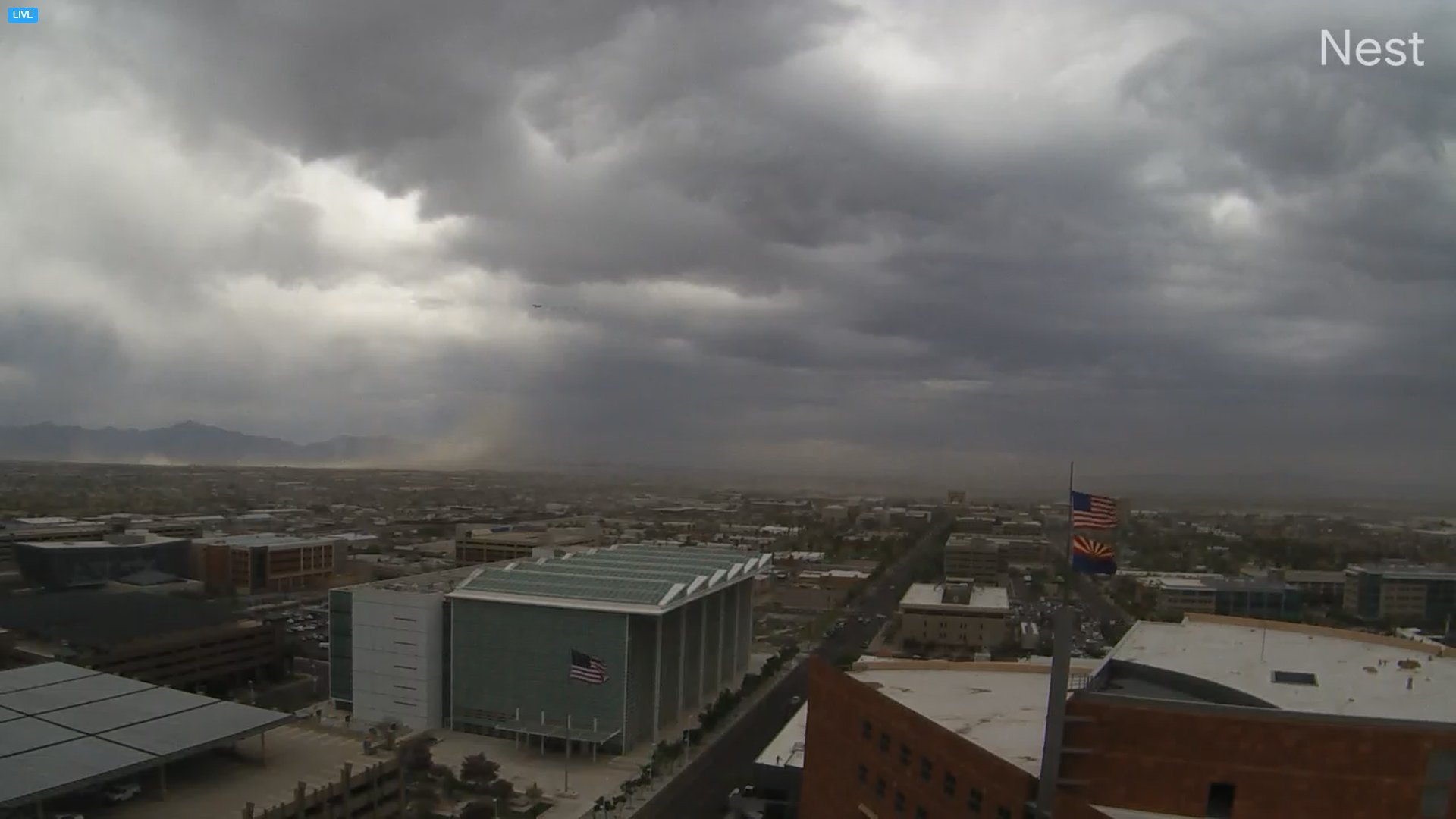
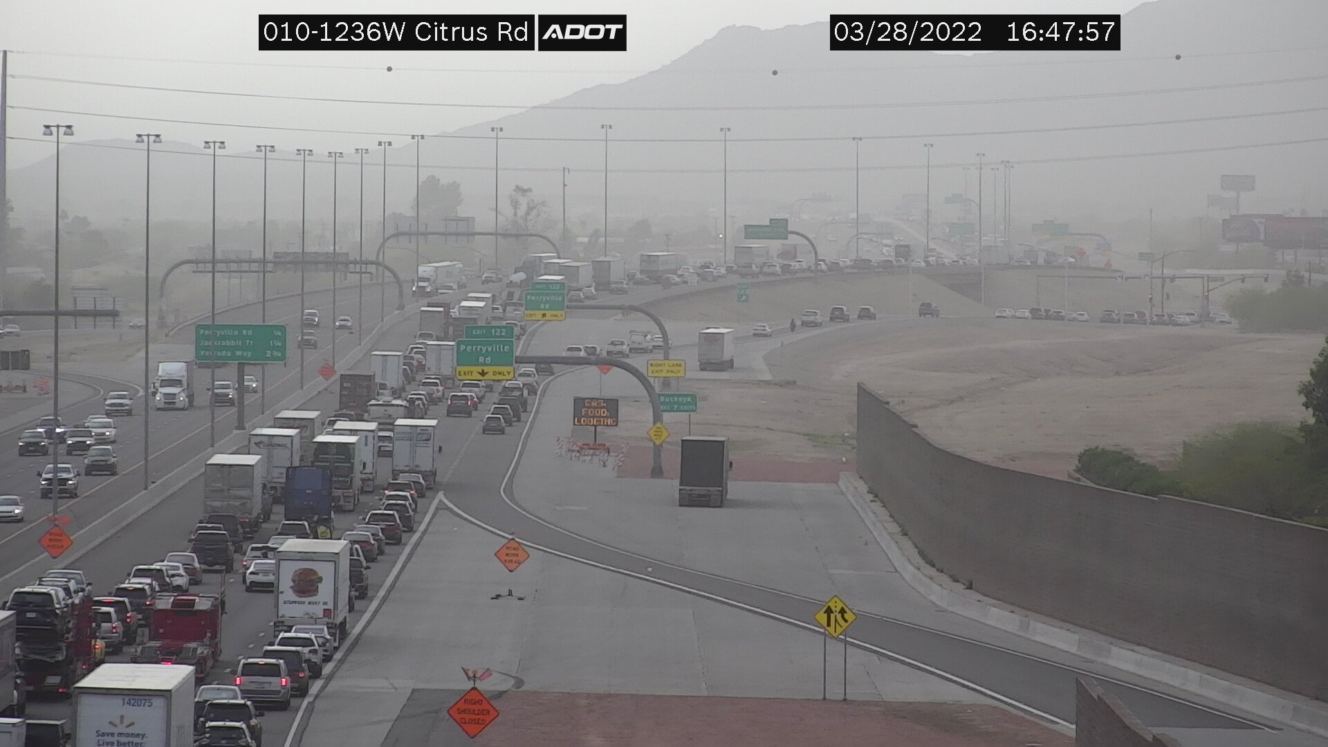
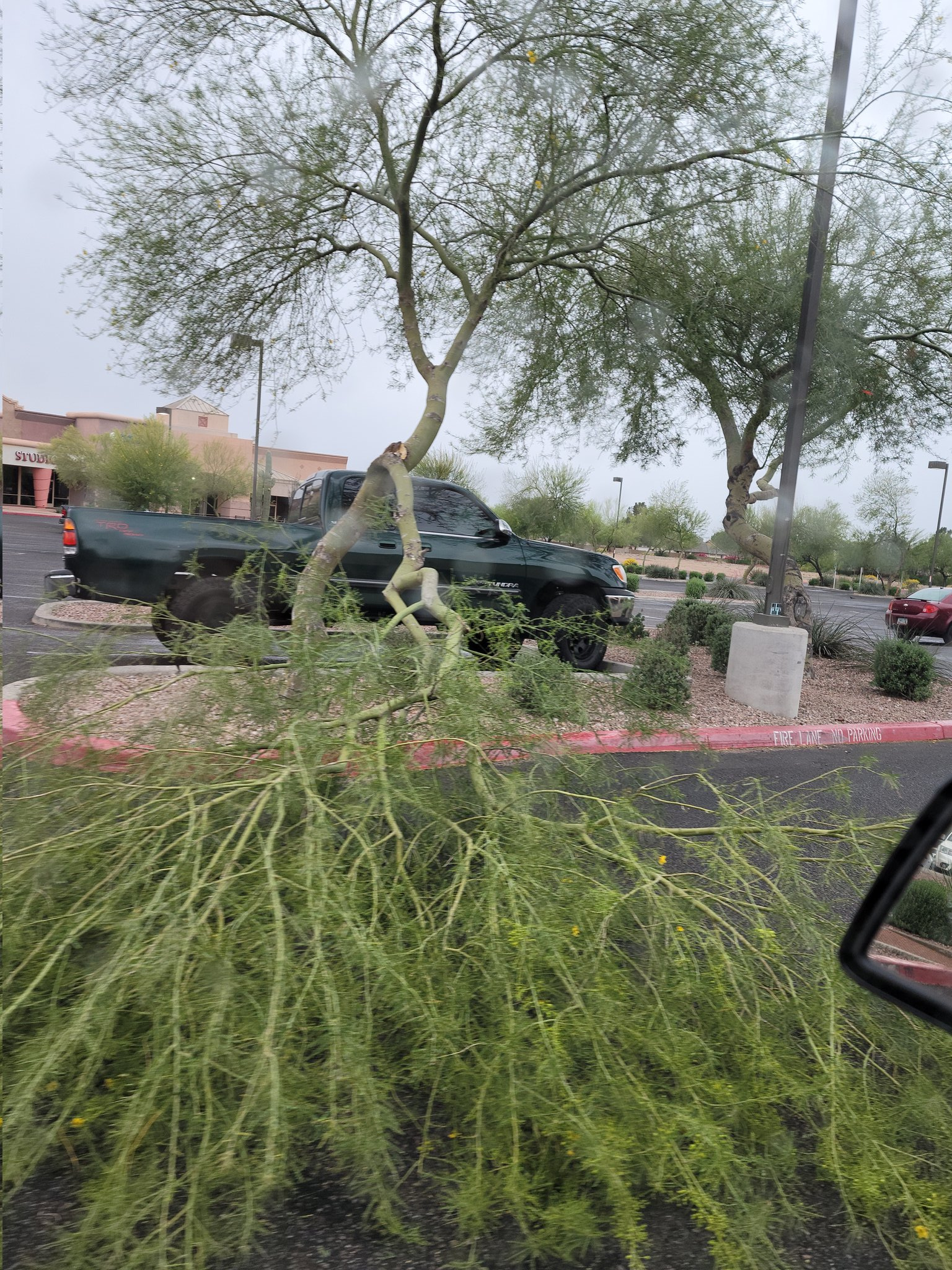
Fig. 2-5 - Upper left: Large limb of a palo verde tree snapped off in Mesa (credit: @SaralynMN on Twitter), Upper right: Destroyed carport landed in front yard of a home, originating from another home a couple doors down (credit: Dennis Griffin), Bottom left: City of Phoenix webcam from downtown Phoenix looking west at dust blowing in from the south, and Bottom right: Arizona Department of Transportation traffic cam showing dusty conditions near the L-303 & I-10 interchange. |
|
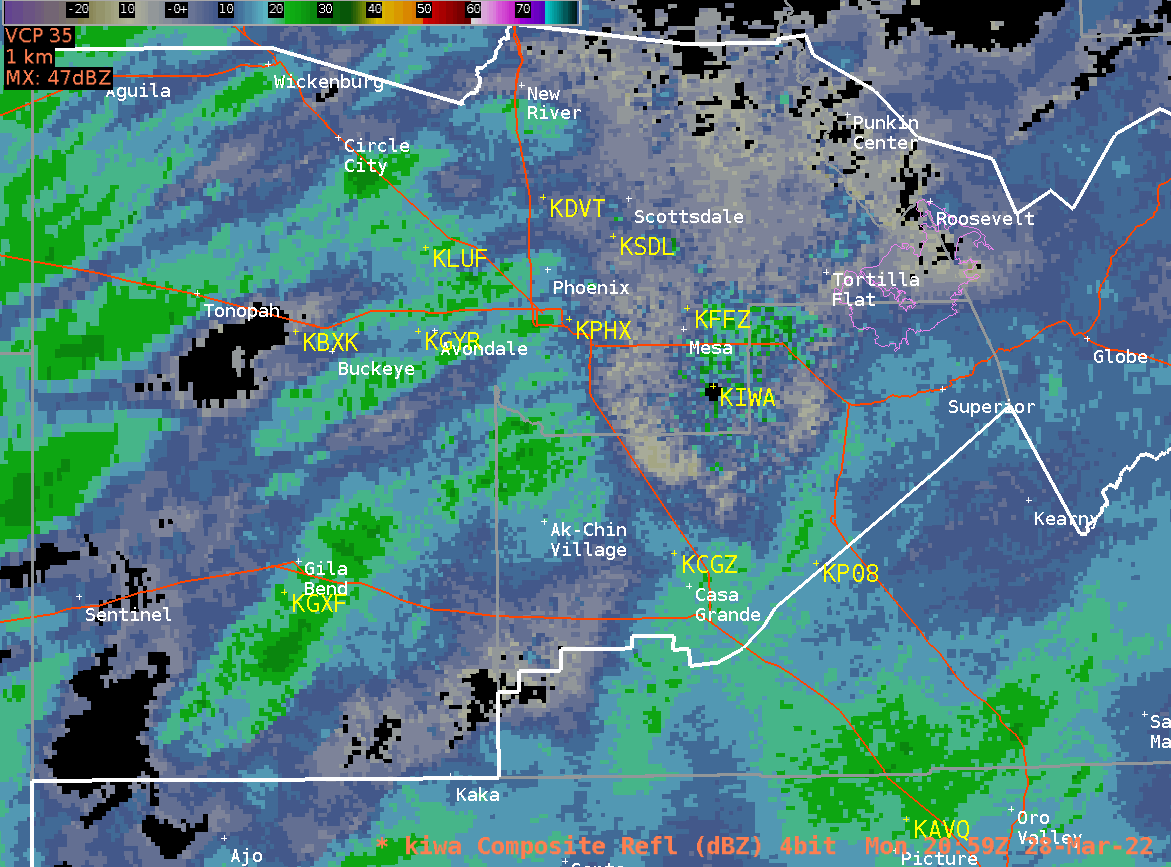
How is it possible to receive severe-level straight line winds (58+ mph) from light showers? The short answer… through a similar process to how downbursts generate severe winds during the monsoon. The air below the cloud base was very dry and as precipitation fell into this dry layer it evaporated and cooled rapidly. This cooler, more dense, air then accelerated to the surface and spread out horizontally, producing the strong winds. As precipitation continued to fall into and saturate the dry sub-cloud layer, rain began reaching the surface and winds gradually settled. The strongest wind gusts all occurred on the leading edges of the main cluster of rain showers (see Figure 6 for a radar loop).
|
|
|
Fig. 6 - Composite reflectivity loop from the Phoenix weather radar (KIWA). Timeframe is 2059Z to 0130Z (1:59 -6:30 PM MST). The 59 mph peak wind gust at Falcon Field Airport (KFFZ) occurred at 2300Z (4:00 PM MST). |
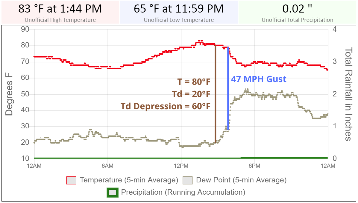
Light rain falls into dry sub-cloud layers all the time here in the Desert Southwest. How was this event more extreme than other occurrences? There are a couple factors that may have aided in the magnitude of wind gusts. One factor is the depth and magnitude of the dry sub cloud layer, helping maximize the evaporative cooling. Cloud bases over the greater Phoenix metro area were initially around 9-10 thousand feet above the surface, which is not too dissimilar to cloud bases during the monsoon. Surface dew point depressions were also quite high, around 55-60°F, with ambient temperatures around 80°F and dew points around 20-25°F (see Figure 7). These depression magnitudes are also commonly seen during the monsoon. The other factor is the presence of a 25-35 mph southerly gradient wind above the surface, that developed in response to the approaching upper level low pressure system. The momentum transfer from the rapidly descending cool air likely helped mix the southerly winds down to the surface.
|
|
|
Fig. 7 - Phoenix Sky Harbor Airport (KPHX) Hi-Res ASOS observations, showing ambient temperature (T), dew point (Td), and rainfall on March 28, 2022. Annotated on the plot is the dew point depression (Td Depression: T-Td) before the rain cooled air arrived and when KPHX experienced its peak southerly wind gust of 47 mph. |


.jpeg)