
Flash flooding threatens areas from the Tennessee Valley to the Carolinas as storms repeat along a stalled front. Monsoonal storms may trigger flooding in the Southwest. Dangerous heat expands across the Desert Southwest, Plains, mid-Mississippi Valley and Southern Tier. Critical fire weather for interior Pacific Northwest. Cooler, drier air brings brief relief to the Great Lakes and Northeast. Read More >
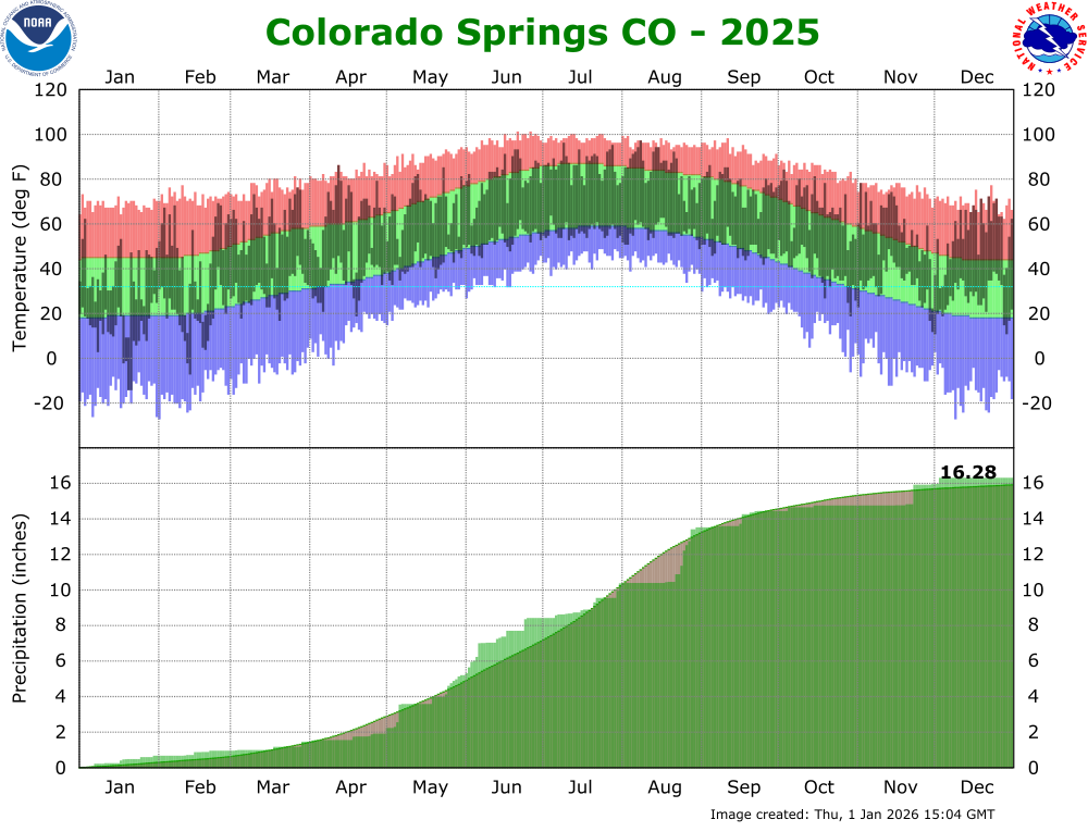
2025 started out cold, especially across eastern Colorado, which saw several cold air outbreaks throughout the month, culminating in the late January 17th through January 21st timeframe, when a true Arctic airmass moved across Colorado. In true Colorado fashion, the end of the Arctic outbreak saw temperatures in both Colorado Springs (61F) and Pueblo (68F) warm over 60 degrees in less than 24 hours! February saw up and down temperatures and precipitation, especially across eastern Colorado, where a few polar intrusions brought periods of very cold temperatures and precipitation to southeast Colorado.
March was a generally warm and windy month across south central and southeast Colorado. This brought increased fire danger to the snow free areas, as well as a few days with reduced visibility due to blowing dust across southern Colorado. A few passing weather systems did bring cooler temperatures and some precipitation, most notably a system on March 18th and 19th, which brought a period of heavy wind driven snow to portions of the southeast Plains. April was a roller coaster type of month, with cool and wet periods at the beginning and middle of the month, along with warm, dry and windy periods in between. This also brought increased fire danger to the snow free areas for much of April. May was another roller coaster type of month, with slow moving weather systems bringing cool and wet periods at the beginning, middle and end of the month, along with a few warm, dry and windy periods in between. However, the above normal precipitation and associated green up helped to taper fire danger across the area.
June was a fairly active month, with several passing weather systems bringing cool and wet periods through out the month, including periods of severe weather across eastern Colorado. June also saw periods of upper level ridging allowing for warm and dry periods through out the month as well. July saw a meandering ridge of high pressure across the Rockies, which brought periods of warm and dry conditions, as well as cooler and wetter periods, with periods of severe weather and heavy monsoon rainfall across south central and southeast Colorado. August also saw a meandering ridge of high pressure across the Rockies, which brought periods of very warm and dry conditions, as well as cooler and wetter periods. There were also periods of severe weather and heavy monsoon rainfall across portions of south central and southeast Colorado, especially in the last 10 days of the month.
September continued the previous few months weather pattern of a meandering ridge of high pressure across the Rockies, which brought periods of warm and dry conditions, as well as cooler and wetter periods. There were also periods of severe weather and heavy rainfall across portions of south central and southeast Colorado. October also saw a meandering ridge of high pressure across the Rockies, which brought mainly warm and dry conditions to the region as a whole. However, periods of heavy rainfall and flooding were experienced across portions of southwestern Colorado, and into western portions of south central Colorado, in the October 9th through 14th timeframe, when remnants of Hurricane Priscilla moved across western portions of the state. Widespread rainfall totals of 2 to 6 inches were recorded over that 5 day timeframe, with local amounts of almost 8 inches recorded at the Wolf Creek SNOTEL station. November was very warm and mainly dry across south central and southeast Colorado. However, a few passing weather systems towards the end of the month brought some areas of rain, with Colorado Springs setting a new daily rainfall record of 1.10 inches on November 23rd. December was very warm and dry across south central and southeast Colorado, save for one passing storm system at the beginning of the month, which did bring some rain and snow to the area.
...THE COLORADO SPRINGS CO CLIMATE SUMMARY FOR THE YEAR OF 2025...

CLIMATE NORMAL PERIOD 1991 TO 2020
CLIMATE RECORD PERIOD 1894 TO 2026

WEATHER         OBSERVED          NORMAL  DEPART
                VALUE   DATE(S)   VALUE   FROM
                                          NORMAL
................................................
TEMPERATURE (F)
RECORD
 HIGH            101   06/21/2016
                       06/26/2012
                       06/26/2012
 LOW             -27   02/01/1951
                       12/09/1919

HIGHEST           97   08/08
LOWEST           -14   01/20
                       01/21
AVG. MAXIMUM    65.2               64.1     1.1
AVG. MINIMUM    37.8               36.8     1.0
MEAN            51.5               50.4     1.1

DAYS MAX >= 90    22
DAYS MAX <= 32    22
DAYS MIN <= 32   125
DAYS MIN <= 0      6

PRECIPITATION (INCHES)
RECORD
 MAXIMUM       27.58   1999
 MINIMUM        6.07   1939

TOTALS         16.28              15.91    0.37

DAILY AVG.      0.05               0.04    0.01
DAYS >= .01       94
DAYS >= .10       44
DAYS >= .50        7
DAYS >= 1.00       2

GREATEST
 24 HR. TOTAL   1.10   08/25 TO 08/26
                       11/23 TO 11/23

SNOWFALL (INCHES)
RECORDS
 MAXIMUM        96.4   1957
 MINIMUM        11.7   2012

TOTALS          27.5               32.5    -5.0
SINCE 7/1        5.2               11.2    -6.0

SNOWDEPTH AVG.     0
DAYS >= TRACE     53               27.1    25.9
DAYS >= 1.0       10               11.0    -1.0
GREATEST
 SNOW DEPTH        4   01/25
                       12/03
                       12/04
 24 HR TOTAL     4.9   12/02 TO 12/03

DEGREE DAYS
HEATING TOTAL   5326               5888    -562
 SINCE 7/1      1750               2390    -640
COOLING TOTAL    522                608     -86
 SINCE 1/1       522                608     -86

FREEZE DATES
RECORD
 EARLIEST     09/01/1911
 LATEST       06/03/1951

EARLIEST                        10/19
LATEST                          04/20
................................................

WIND (MPH)
AVERAGE WIND SPEED              9.1
RESULTANT WIND SPEED/DIRECTION   1/050
HIGHEST WIND SPEED/DIRECTION    46/340    DATE  03/03
HIGHEST GUST SPEED/DIRECTION    64/340    DATE  03/04

SKY COVER
AVERAGE SKY COVER           0.50
NUMBER OF DAYS FAIR           98
NUMBER OF DAYS PC            217
NUMBER OF DAYS CLOUDY         50

AVERAGE RH (PERCENT)     52

WEATHER CONDITIONS. NUMBER OF DAYS WITH
THUNDERSTORM             80     MIXED PRECIP               8
HEAVY RAIN               26     RAIN                      46
LIGHT RAIN              117     FREEZING RAIN              0
LT FREEZING RAIN          0     HAIL                       5
HEAVY SNOW                2     SNOW                      12
LIGHT SNOW               48     SLEET                      0
FOG                      88     FOG W/VIS <= 1/4 MILE     22
HAZE                      2

-  INDICATES NEGATIVE NUMBERS.
R  INDICATES RECORD WAS SET OR TIED.
MM INDICATES DATA IS MISSING.
T  INDICATES TRACE AMOUNT.
 |

