Seamless Bathy-Topo Digital Elevation Models Supporting Surge and Inundation Modeling
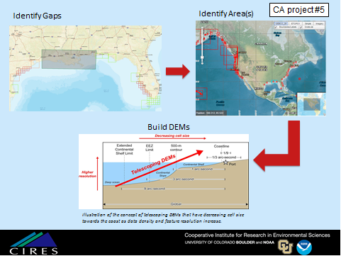
In meeting the requirements of the COASTAL Act Capabilities Development Plan (CACDP), NCEI, with support from NOAA's Office for Coastal Management (OCM), identified and evaluated existing coastal elevation datasets, including source data (i.e. lidar surveys) and derivative products (i.e. DEMs). The gap analysis included assessing the data quality, spatial extent and date of acquisition and/or creation (in the case of DEMs). The comparison of existing modern DEMs with up-to-date available source topographic and bathymetric data helped inform area(s) of interest for DEM development. Using the DEM assessment and gap analysis, NCEI and the COASTAL Act modelers prioritized areas of interest.
NCEI is following procedures developed and tested under the Disaster Relief Appropriation for Hurricane Sandy to build the suite of seamless topographic-bathymetric and bathymetric high-resolution telescoping DEMs for the identified areas of interest. DEMs developed along the coast have a spatial resolution of 1/9 arc-second (~3m) and coarsen to 1/3 arc-second (~10m) offshore.
Seamless bathy/topo digital elevation models supporting surge inundation modeling