
Wildfire smoke continues to impact air quality from the Great Lakes region into New England and the Mid-Atlantic today with widespread Air Quality Alerts in effect. Severe thunderstorms are expected across portions of the Ohio Valley and Lower Great Lakes into the Mid-Atlantic and Northeast, this afternoon into the evening. Monsoonal thunderstorms may bring areas of flooding to the Southwest. Read More >
Today |
|
| Today's Overall Severe Weather Risk | Today's Tornado Risk |
 |
 |
| Today's Damaging Wind Risk | Today's Large Hail Risk |
 |
|
| Click to enlarge graphics | |
Tomorrow |
|
| Tomorrow's Severe Weather Risk | Tomorrow's Tornado Risk |
 |
 |
| Tomorrow's Damaging Wind Risk | Tomorrow's Large Hail Risk |
 |
 |
| Click to enlarge graphics | |
Day 3 Severe Weather Risk |
|
 |
 |
| Click to enlarge graphics | |
Western Montana |
|
 |
 |
 |
 |
| Click to enlarge graphics | |
North-Central Montana |
|
 |
 |
 |
 |
| Click to enlarge graphics | |
Central and Southwestern Montana |
|
 |
 |
 |
 |
| Click to enlarge graphics | |
Eastern Montana |
|
 |
 |
 |
 |
| Click to enlarge graphics | |
| For severe timing graphics for additional cities and for Day 2 severe timing graphics click here. |
|
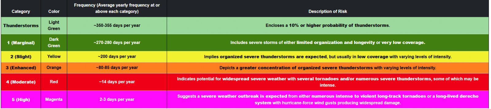
Explanation of SPC Outlook Categories |
|
 |
|
| Click to enlarge graphics | |
| See this image for more information on the new Conditional Intensities in SPC Outlooks. | |
| Visit the Storm Prediction Center Website for more information on potential severe weather over the next few days |
| Current Severe Thunderstorm & Tornado Watches | |
 |
 |
| Today's Tornado, Wind & Hail Reports | Yesterday's Tornado, Wind & Hail Reports |
 |
 |
Click to enlarge graphics


 Great Falls Radar
 Satellite
 Current Observations
 Forecast Discussion
 Montana Weather
 Fire Weather
 Winter Weather Forecasts
 Transportation Forecasts
 Weather Prediction Center
 Storm Prediction Center
 Aviation Weather
 Weather Stats