Overview
|
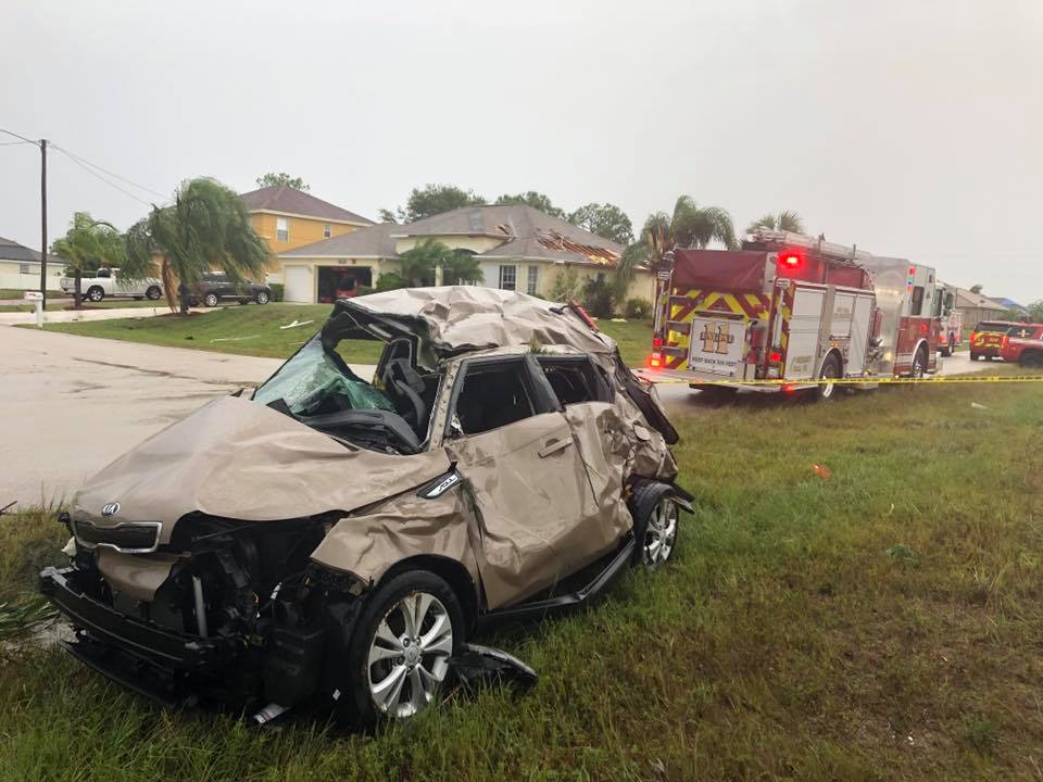
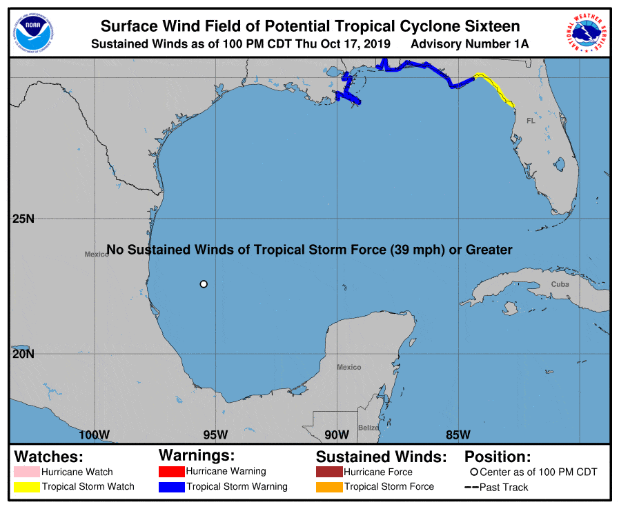
All images on this page may be expanded with a single click and returned to original size with a second click. Tropical Storm Nestor had its origins from an broad area of low pressure over the Bay of Campeche on October 17th, 2019. The system was classified a potential tropical cyclone on the 17th due to a high chance of development and short duration of time till impacts would be felt along the northern Gulf coast. The low pressure became Tropical Storm Nestor on Friday October 18th. Nestor was not a typical tropical cyclone, as after forming, the storm quickly began to interact with another upper level disturbance moving off the Texas coast. The two systems came together to produce a storm that was more a hybrid between a tropical cyclone and an ordinary extra-tropical cyclone. During the day on Friday into Friday evening, a large area of rain/thunderstorms associated with Nestor overspread the region, persisting into Saturday morning. Many locations saw 1-4" of rainfall by the time all was said and done. Nestor also resulted in minor coastal flooding along the northeast Gulf of Mexico coast, with many locations seeing tides of 2-4 feet above normal. However, Nestor will likely be most know in west-central and southwest Florida for a tornado outbreak. At least three tornadoes were confirmed, including a long-track EF-2 tornado that did considerable damage to parts of western Polk county. TS Nestor Advisory Summary
|
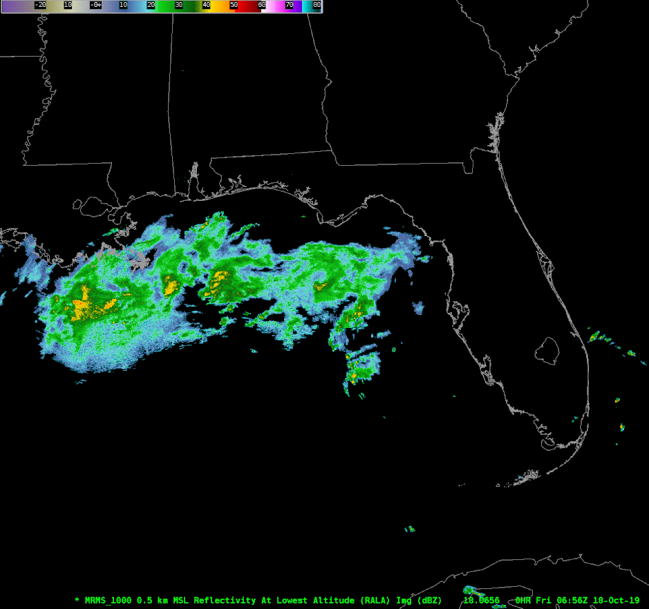
Radar Loop 10/18/19 - 10/19/19
Nestor Full Track
|
Tornadoes:
|
Tornado - Seminole, FL
Warning & Tornado Damage Report Location Map 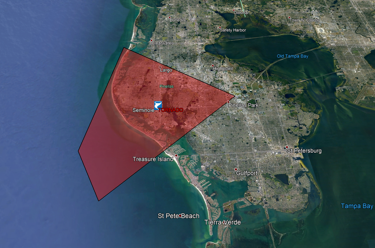
|
||||||||||||||||
|
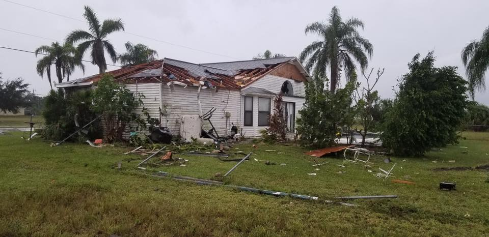
Tornado - Lakeland Vicinity to Kathleen
Warning & Tornado Damage Report Location Map 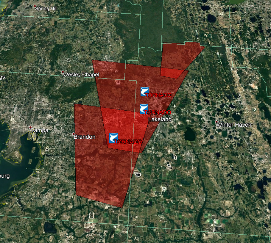 |
||||||||||||||||
|
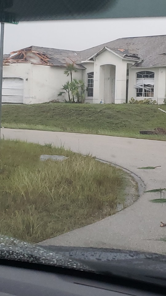
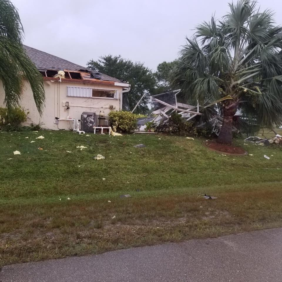
Tornado - Cape Coral
Track Map 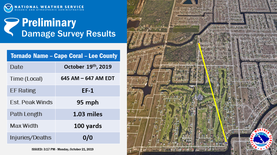 |
||||||||||||||||
The Enhanced Fujita (EF) Scale classifies tornadoes into the following categories:
| EF0 Weak 65-85 mph |
EF1 Moderate 86-110 mph |
EF2 Significant 111-135 mph |
EF3 Severe 136-165 mph |
EF4 Extreme 166-200 mph |
EF5 Catastrophic 200+ mph |
 |
|||||
Photos & Video
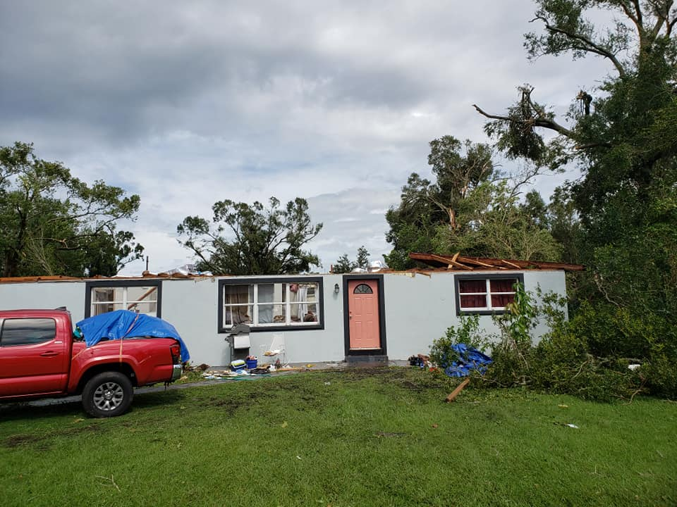
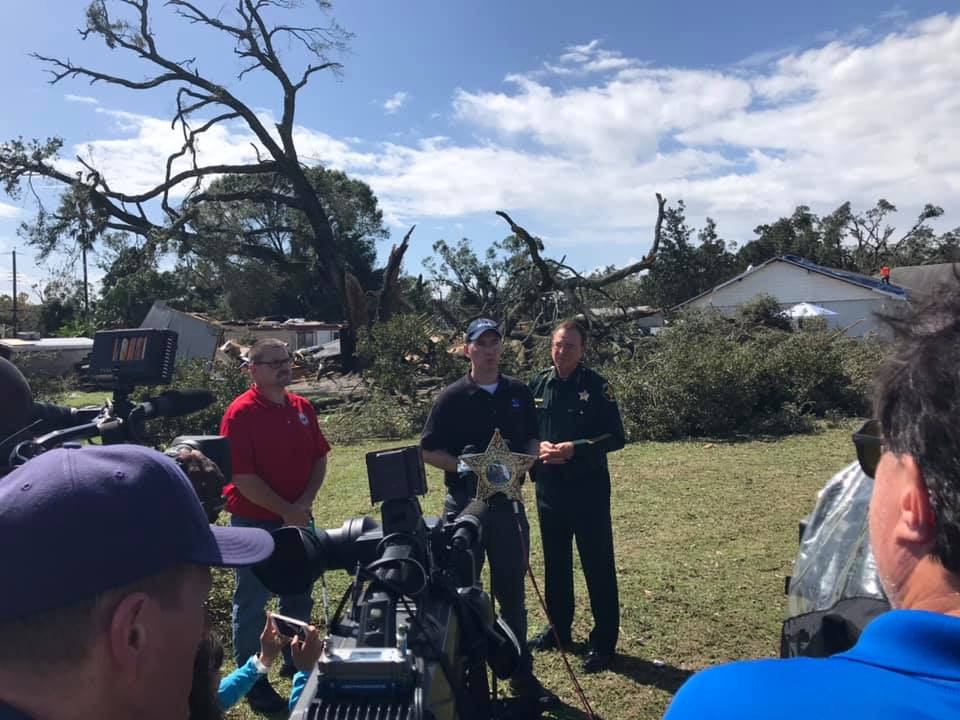
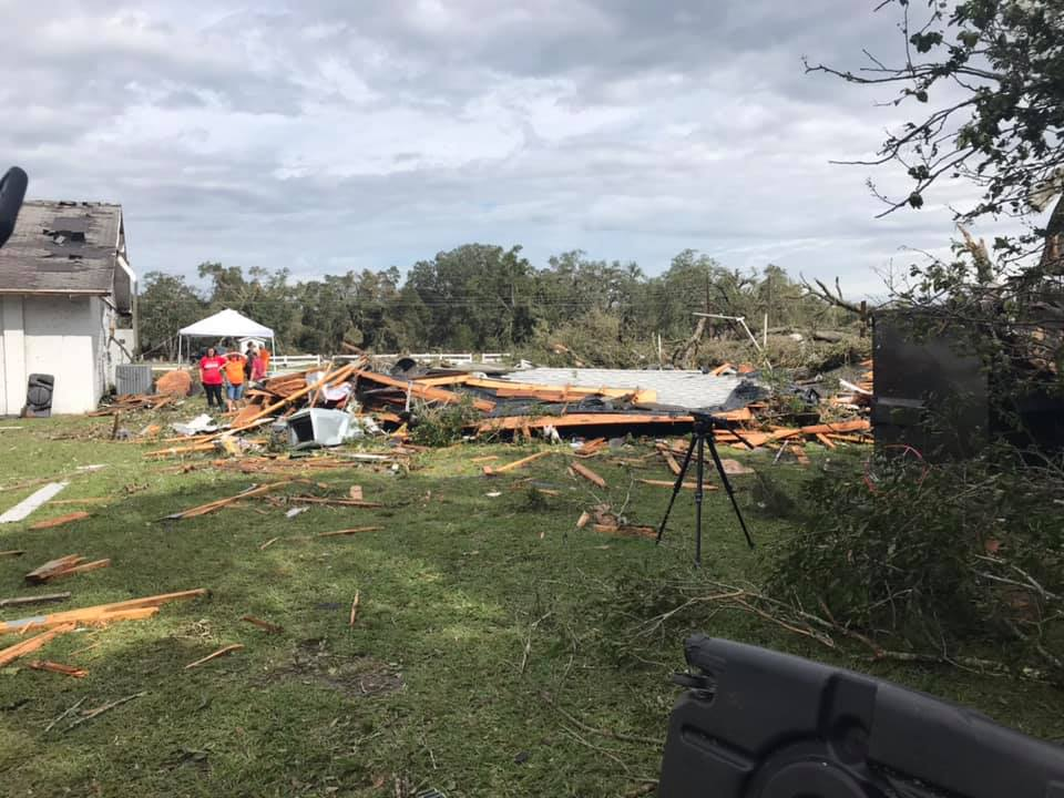
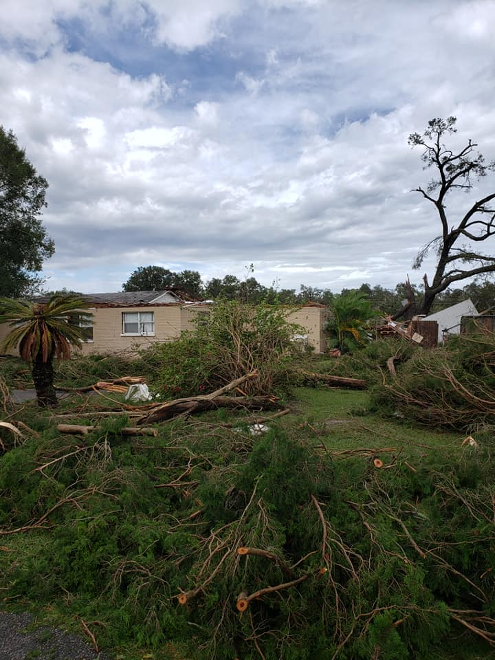
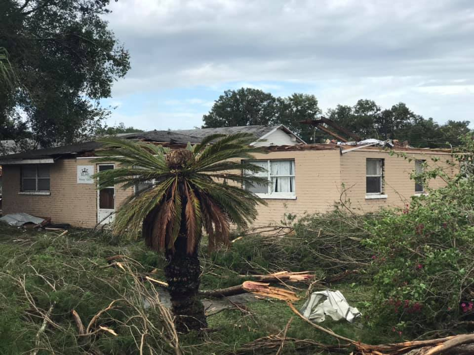
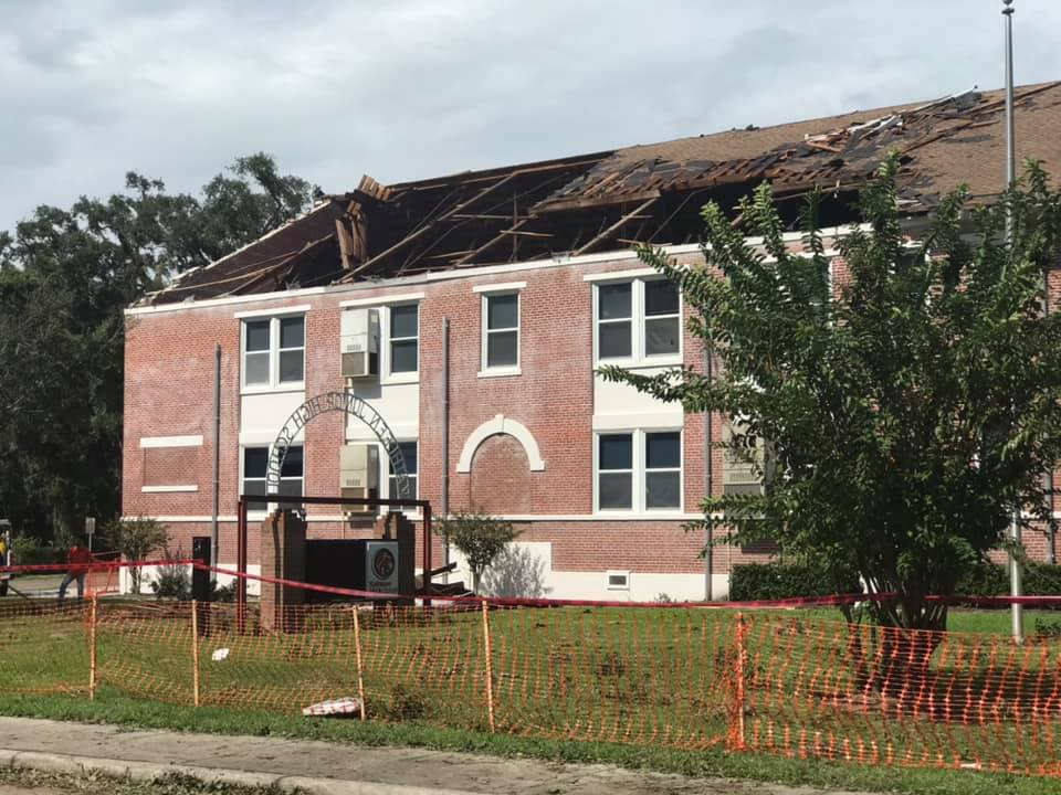
Polk County EF-2 Tornado
 |
 |
 |
| Photo by NWS Survey Crew | Photo by NWS Survey Crew |
Photo by NWS Survey Crew |
 |
 |
 |
| Photo by NWS Survey Crew | Photo by NWS Survey Crew | Photo by NWS Survey Crew |
 |
 |
 |
| Photo by NWS Survey Crew |
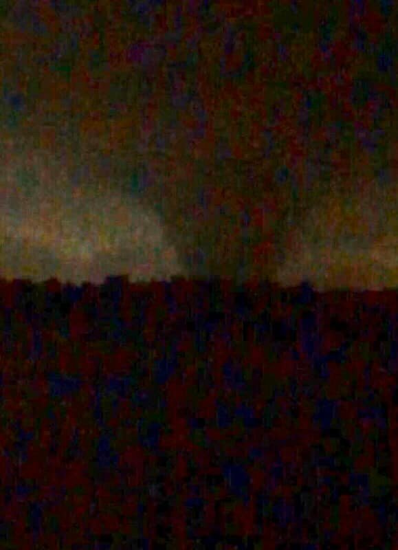
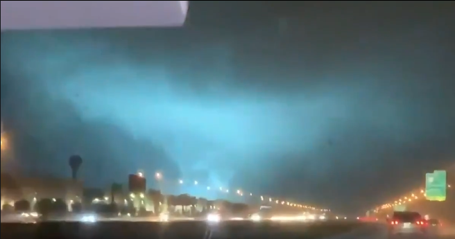
Polk EF-2 Tornado Photo Credit: Mellissa Korta |
Polk EF-2 Tornado - Still image from video as tornado is illuminated by a power flash after crossing I-4 near Lakeland: Credit: Mellissa Korta |
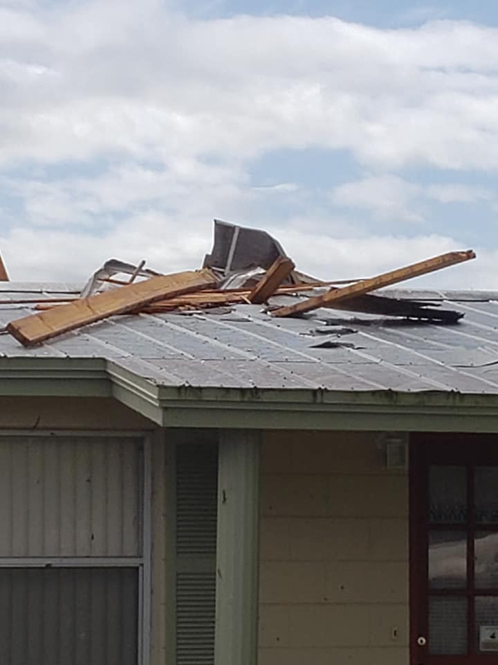
Cape Coral - Lee County EF-1 Tornado:
 |
 |
 |
| Photo shared by NBC-2 Fort Myers | Photo shared by NBC-2 Fort Myers |
Photo shared by NBC-2 Fort Myers |
 |
||
| Photo shared by NBC-2 Fort Myers |
|
|
|
|
Radar
Radar Snapshots
 |
 |
 |
|
|
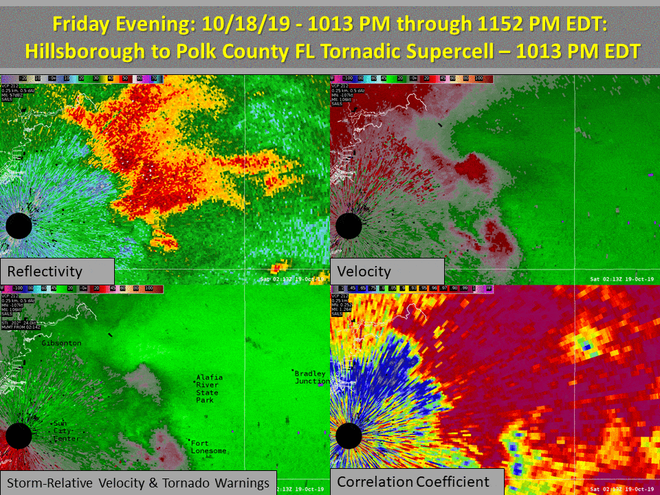
Hillsborough / Polk County Tornadic Supercell - October 18th, 2019 0.5 elevation: Reflectivity / Base Velocity, Storm Relative Vel / Correlation Coeffient |
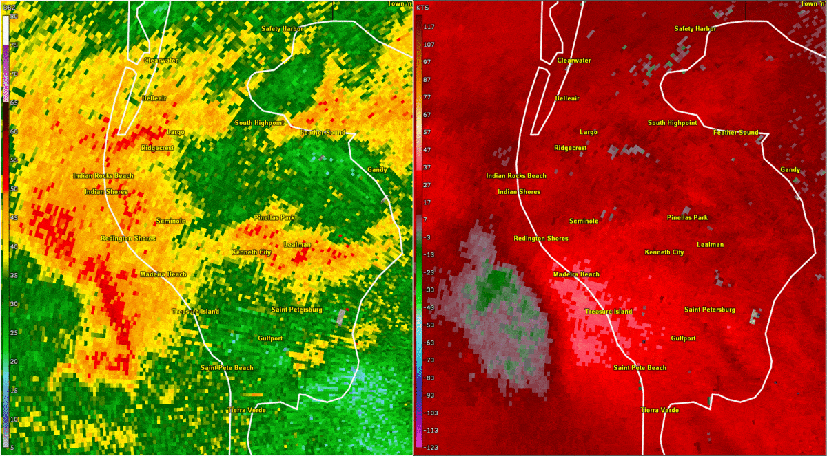
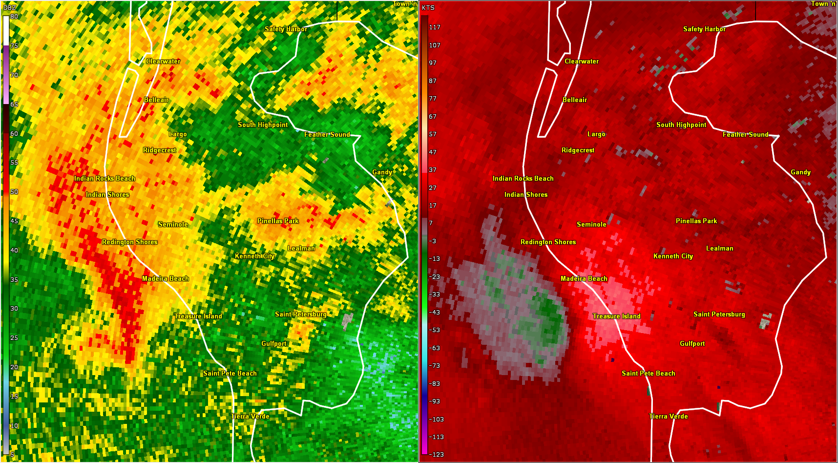
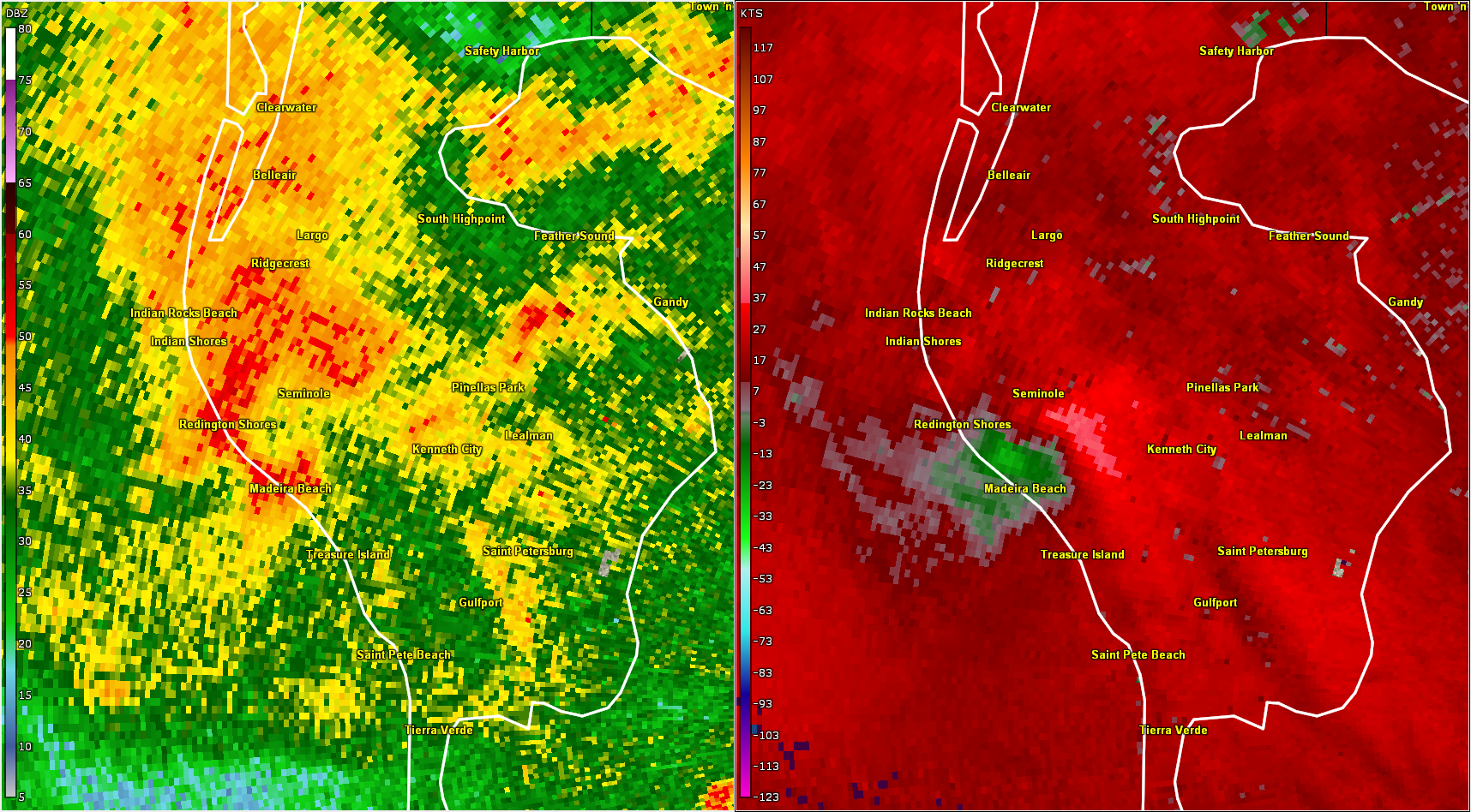
Pinellas County - Seminole Tornadic Supercell - October 18th, 2019 0.5 elevation: Reflectivity & Storm Relative Velocity |
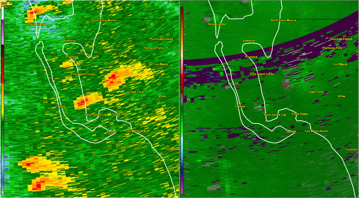
Lee County - Cape Coral Tornadic Supercell - October 18th, 2019 0.5 elevation: Reflectivity & Storm Relative Velocity |


|


|


|
 |
 |
 |
| Polk County EF-2 Tornado showing a defined hook echo and reflectivity "debris ball" on the left and radar indicated debris from correlation coefficient on the right | 3-D rendering of the higest reflectivities associated with the Polk County supercell. The appendage on the right shows a proxy for the tornadic funnel, as the higher reflectivity is resulting from debris lofted within the tornado | MRMS (Multi-Sensor-Multi-Radar) rainfall estimation statistics across the region for the full duration of Tropical Storm Nestor. |
Environment
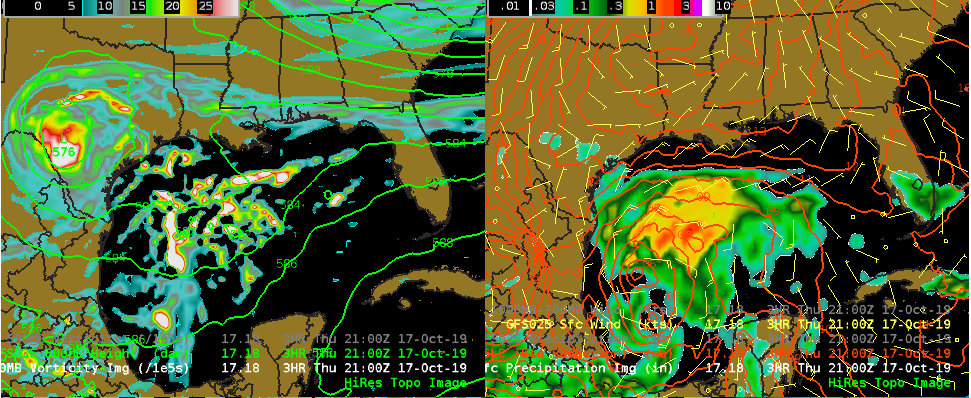
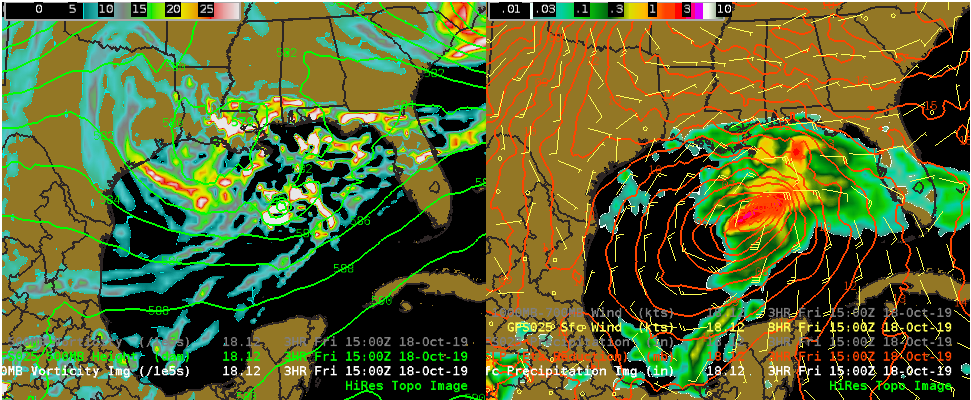
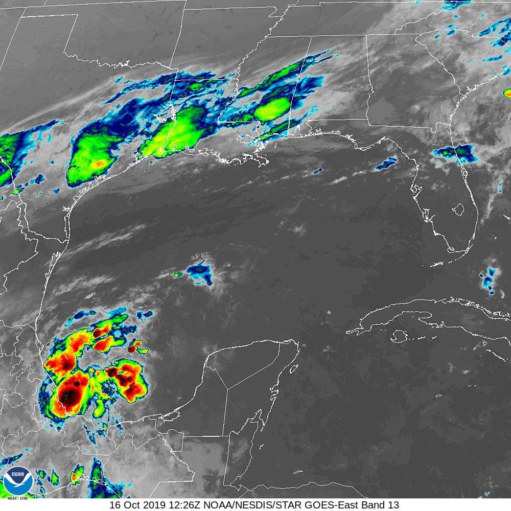
Nestor was only purely tropical in structure for a short period of time before taking on hybrid characteristics. This transition was the result of the storm merging with another disturbance in the upper levels of the atmosphere moving off the Texas coast. The images below show the forecast for Nestor off the 10/17/2018 18UTC run of the Global Forecast System (GFS). In each image, the left panel is 500mb (approx 20KFT) geopotential height and absolute vorticity, and the right panel shows Mean Surface Level Pressure, 10-m winds, and 3-hr precipitation. During the evening of the 17th, the system that would become Nestor is slowly organizing in the southwestern Gulf of Mexico, while the upper level disturbance that will later merge with Nestor is seen over south-central Texas. By the morning of the 18th, The two systems are merging over the north-central Gulf of Mexico. While the extra energy likely helped strengthen Nestor, it also took away many of the tropical characteristics, with Nestor taking on hybrid classification and developing a frontal structure. The last panel from the morning of the 19th, shows Nestor near the time of landfall, now having almost completed extra-tropical transition. Extra-tropical transition just means the system now resembles the structure similar to a typical east coast Nor' Easter type cyclone, as opposed to a tropical cyclone. A defined cold front has formed and now extends to the south of the low center over the eastern Gulf of Mexico.
 |
 |
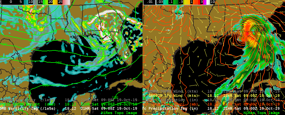 |
| October 17, 2019 5PM EDT Forecast | October 18, 2019 11am EDT Forecast | October 19, 2019 5am EDT Forecast |
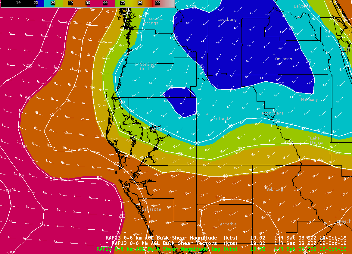
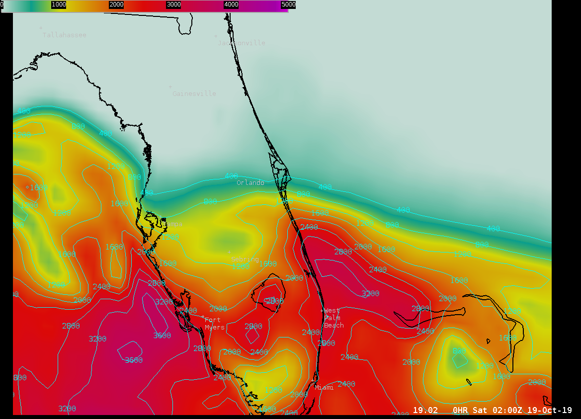
Tropical Storm Nestor will likely be most remembered in west-central and southwest Florida for a series of tornadoes. The biggest tornado that occurred was an EF-2 long-track tornado that occurred in western Polk County. Here we will discuss some of the environmental conditions that were in place for the supercell thunderstorm and resulting tornado to occur. On the left we find a plot from the RAP model of deep layer (0-6km) shear. Values in the storm initiation area are around 35kts, which is plenty to support organized convection. In the middle we see a plot of the surface based convective available potential energy (CAPE). A large gradient in the energy can be seen along the I-4 corridor, suggesting we have some sort of boundary/warm front lying through this area. The supercell that formed the Polk County tornado initiated in the high energy air just south of this boundary. Finally, on the right we see a plot of storm relative helicity. The higher these values, the more favorable the environment to support low level spin. The higher values "nosing" into west-central Florida as likely the result of the boundary in place. Stationary boundaries like this are associated with low level vorticity (spin), and storm can ingest this spin into their updrafts as they move over the boundary. This process is very likely what happened during Nestor when this particular supercell crossed the boundary. As the storm moved further to the north, the environment became less favorable and the tornado decayed and lifted.
 |
 |
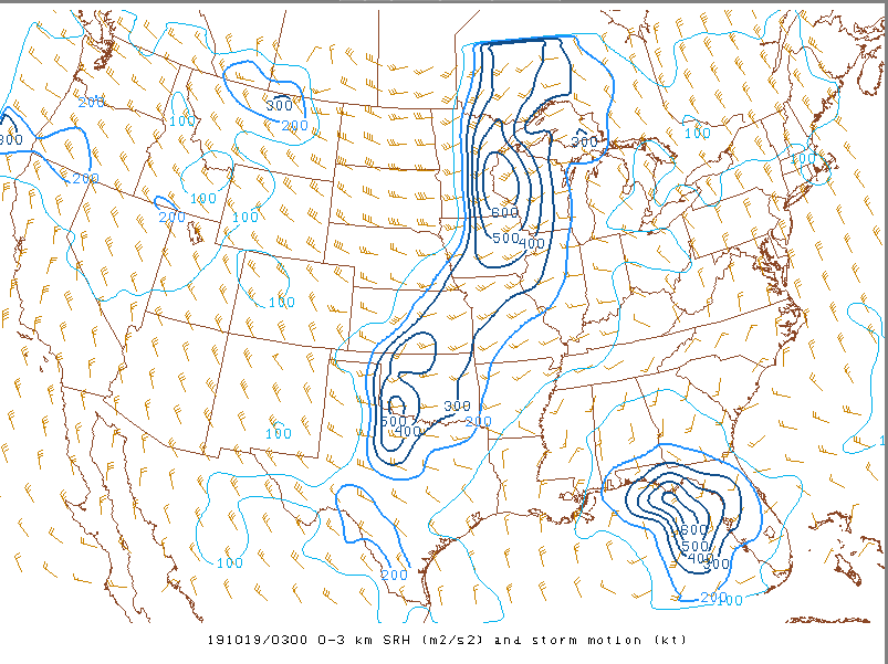 |
| 0-6km shear 03Z | SFC-based CAPE 02Z | 0-3km SRH |
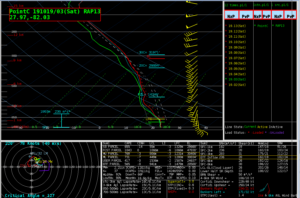
Below we see a RAP forecast sounding for the location the tornado formed. The wind plots on the right show winds quickly veering from the southeast to southwest within the first few thousand feet. This veering profile produces the long looping hodograph seen in the lower left portion of the plot is is favorable for the formation and sustaining of rotating updrafts. In addition, the critical angle with this wind profile is around 127. Critical angles in the range of 45 to 135 degrees suggest near-surface vorticity is more streamwise than crosswise. Recent studies have correlated streamwise vorticity with more favorable environments for longer track tornadoes.
For more information on "critical angle", please visit https://www.spc.noaa.gov/exper/mesoanalysis/help/help_crit.html
 |
||
| RAP sounding 03Z / 11PM EDT 10/18/19 at location of Polk County tornado formation |
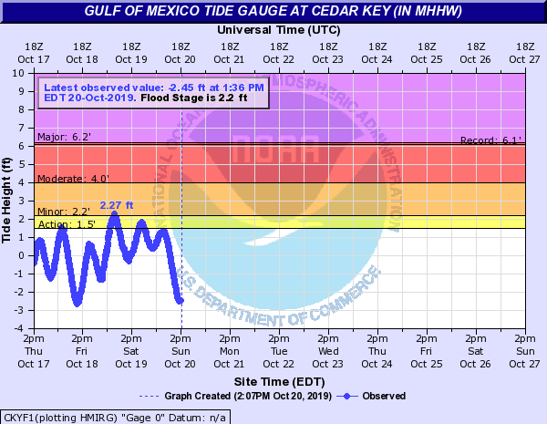
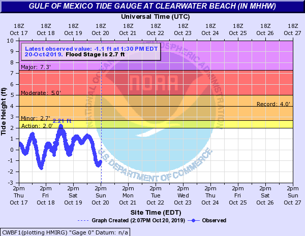
Coastal Flooding
Tropical Storm Nestor resulted in minor coastal flooding issues along the northeast Gulf of Mexico. The highest tide cycle associated with the storm ranged from generally 2-4 feet above normal from Apalachicola around the Florida Big Bend and down to portions of Pinellas County. The higher than normal tides from Cedar Key southward resulted in brief periods of tidal over-wash, a few closed roads, and minor beach erosion.
 |
 |
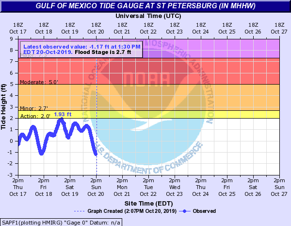 |
| Cedar Key, FL | Clearwater Beach, FL | St Petersburg, FL |
Satellite
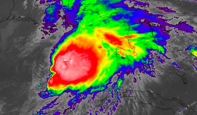
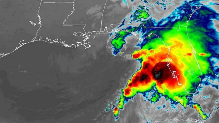
Various Development Stages of TS Nestor
 |
 |
 |
|
| Early stages of Nestor's development during the morning of October 16th | Thunderstorm activity associated with Nestor flaring during Friday October 18th as the Tropical Storm was interacting with an upper disturbance moving in from the western Gulf of Mexico. | Tropical Storm Nestor early on October 19th prior to landfall in the Florida panhandle. Nestor has become a hybrid system with a defined cold front extending south across the eastern Gulf of Mexico. Much of the rainfall and thunderstorm with Nestor are now ahead of this front over the Florida peninsula. |


 Follow us on YouTube