HOME
FORECAST
Local
Graphical
Aviation
Marine
Rivers and Lakes
Hurricanes
Severe Weather
Fire Weather
Sunrise/Sunset
Long Range Forecasts
Climate Prediction
Space Weather
PAST WEATHER
Past Weather
Astronomical Data
Certified Weather Data
SAFETY
INFORMATION
Wireless Emergency Alerts
Weather-Ready Nation
Brochures
Cooperative Observers
Daily Briefing
Damage/Fatality/Injury Statistics
Forecast Models
GIS Data Portal
NOAA Weather Radio
Publications
SKYWARN Storm Spotters
StormReady
TsunamiReady
Service Change Notices
EDUCATION
NEWS
SEARCH
Search For
NWS
All NOAA
ABOUT
About NWS
Organization
For NWS Employees
National Centers
Careers
Contact Us
Glossary
Social Media
NWS Transformation
Local forecast by
"City, St" or ZIP code
Sorry, the location you searched for was not found. Please try another search.
Multiple locations were found. Please select one of the following:
Location Help
News Headlines
Register Here for the Virtual Florida Public Tropical Training Week 2026!
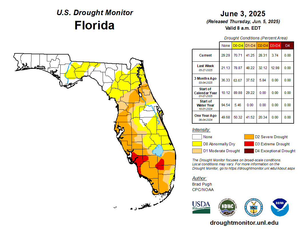
Abnormally Dry to Extreme Drought Continues across West Central and Southwest Florida
Customize Your
Weather.gov
Enter Your City, ST or ZIP Code
Remember Me
LOADING...
Tampa Bay Area, FL
Weather Forecast Office
Tampa Bay Area Fire Weather Page
Weather.gov
>
Tampa Bay Area, FL
> Tampa Bay Area Fire Weather Page
Current Hazards
Submit a Storm Report
Graphical Hazards
Outlooks
Current Conditions
Satellite
Observed Precipitation
Surface Observations
Local Observations
Local Beaches
Radar
Local KTBW Standard Radar (low bandwidth)
Local KTBW Enhanced Radar
Local Enhanced Radar (TTPA)
Regional Standard Radar (low bandwidth)
TBW Radar Status
Forecasts
Forecaster's Discussion
Probabilistic Precipitation
Fire
Hourly View
Hot Weather DSS
Tropical
Aviation
Graphical
Hydrology
Marine
Beach
Probabilistic DSS
Experimental HeatRisk
Weather Models
Rivers and Lakes
*New* National Water Prediction Service (NWPS)
*New* NWPS - Local View
Climate and Past Weather
Climate Prediction
Drought
Local Drought / Rainfall Page
Records and Normals
Heat Index Statistics
Dew Point Statistics
1991-2020 Normals
Thunderstorm Climatology
First CG Lightning Convective Environment Browser
ENSO Effect on Our Winter Weather
Arctic Oscillation
Past Weather Summaries and Write-Ups
Local Storm Report (LSR) Map
Tropical Cyclone Reports
Local Programs
SkyWarn
Weather Radio
School Safety
Ambassadors
Office Tour
Newsletter
Weather Events
Weather History
Weather Workouts
Spot Forecast
Spot Forecast/Request
For Help on How to Use
How to pull LVORI Forecast
Forecast Products
Fire Weather Dashboard
National Fire Weather Page
Red Flag Warning/Fire Weather Watch
Fire Weather Forecast
HRRR Smoke Guidance (Experimental)
SPC Fire Weather Outlooks
Latest Observations
Regional Weather Roundup
Florida Automated Weather Network (FAWN) Observations
Weekly Precip Map
Current Satellite and Graphic Links
Satellite Images
Florida Forest Service Current Conditions
Florida Forest Service Current County Burn Bans
Fire Danger Maps and Fire Danger Index (FDI)
Keetch-Byram Drought Index
U.S. Drought Monitor
Operating Plan
Florida Fire Weather Operating Plan
Fire Weather Maps
National 7-Day Significant Fire Potential
Florida Forest Service Fire Maps
NIFC Fire Maps
NIFC Inttera Mapping
NOAA Fire Maps
OSPO Fire and Smoke Products
NASA FIRMS Web Fire Mapper
Fire Environment Mapping System (FEMS)
FDEP Spatial Air Quality System (SAQS)
Other Links
InciWeb - Incident Information System
National Incident Management Situation Report
National Interagency Fire Center
National Interagency Fire Center Wildland Fire Open Data
Southern Area Coordination Center
Fire and Aviation Management
NASA Fire Information for Resource Management System (FIRMS)
Wildfire Weather Safety
Fire Weather Graphics
Latest Florida Drought Monitor
Link to detailed
Local Drought/Rainfall Information
SPC Fire Weather Outlook Day 1
SPC Fire Weather Outlook Day 2
Monthly Wildland Fire Potential Outlook
Next Month's Wildland Fire Potential Outlook
Month 3 Wildland Fire Potential Outlook
Month 4 Wildland Fire Potential Outlook
Follow us on X
Follow us on Facebook
Follow us on YouTube
TBW RSS Feed