HOME
FORECAST
Local
Graphical
Aviation
Marine
Rivers and Lakes
Hurricanes
Severe Weather
Fire Weather
Sunrise/Sunset
Long Range Forecasts
Climate Prediction
Space Weather
PAST WEATHER
Past Weather
Astronomical Data
Certified Weather Data
SAFETY
INFORMATION
Wireless Emergency Alerts
Weather-Ready Nation
Brochures
Cooperative Observers
Daily Briefing
Damage/Fatality/Injury Statistics
Forecast Models
GIS Data Portal
NOAA Weather Radio
Publications
SKYWARN Storm Spotters
StormReady
TsunamiReady
Service Change Notices
EDUCATION
NEWS
SEARCH
Search For
NWS
All NOAA
ABOUT
About NWS
Organization
For NWS Employees
National Centers
Careers
Contact Us
Glossary
Social Media
NWS Transformation
Local forecast by
"City, St" or ZIP code
Sorry, the location you searched for was not found. Please try another search.
Multiple locations were found. Please select one of the following:
Location Help
News Headlines
Register Here for the Virtual Florida Public Tropical Training Week 2026!
Abnormally Dry to Extreme Drought Continues across West Central and Southwest Florida
Customize Your
Weather.gov
Enter Your City, ST or ZIP Code
Remember Me
LOADING...
Tampa Bay Area, FL
Weather Forecast Office
Tampa Bay Area Marine Weather Page
Weather.gov
>
Tampa Bay Area, FL
> Tampa Bay Area Marine Weather Page
Current Hazards
Submit a Storm Report
Graphical Hazards
Outlooks
Current Conditions
Satellite
Observed Precipitation
Surface Observations
Local Observations
Local Beaches
Radar
Local KTBW Standard Radar (low bandwidth)
Local KTBW Enhanced Radar
Local Enhanced Radar (TTPA)
Regional Standard Radar (low bandwidth)
TBW Radar Status
Forecasts
Forecaster's Discussion
Probabilistic Precipitation
Fire
Hourly View
Hot Weather DSS
Tropical
Aviation
Graphical
Hydrology
Marine
Beach
Probabilistic DSS
Experimental HeatRisk
Weather Models
Rivers and Lakes
*New* National Water Prediction Service (NWPS)
*New* NWPS - Local View
Climate and Past Weather
Climate Prediction
Drought
Local Drought / Rainfall Page
Records and Normals
Heat Index Statistics
Dew Point Statistics
1991-2020 Normals
Thunderstorm Climatology
First CG Lightning Convective Environment Browser
ENSO Effect on Our Winter Weather
Arctic Oscillation
Past Weather Summaries and Write-Ups
Local Storm Report (LSR) Map
Tropical Cyclone Reports
Local Programs
SkyWarn
Weather Radio
School Safety
Ambassadors
Office Tour
Newsletter
Weather Events
Weather History
Weather Workouts
Marine Weather
New Marine Page
Graphic Forecasts and Products
SECOORA Marine Weather Portal
NWS Gulf Weather Portal
NOAA nowCoast
Tampa Bay Channels
Radiofax Charts
Weather Charts
Rip Currents
Voluntary Observations
From Mariners
The Perfect Storm
SWAN
- Simulating WAves Nearshore
Marine Links
Florida Tide Information
Tide Information
- Search
Sea Surface Temps
Coastal Waters Forecast
Offshore Waters Forecast for the Gulf
Surf Zone Forecast
Mote Marine
United States Coast Guard
Observations
National Data Buoy Center
Marine Text Forecast and Products Listing
Physical Oceanographic Real-Time System (PORTS)
Coastal Water Temperature Guide
Red Tide References
NCCOS Harmful Algal Bloom Forecast
Florida FWC Red Tide Status
Local Beach Conditions
Red Tide Health Information
Shellfish Harvesting Status
Marine Zones
Select a Marine Zone on the map above to get the Forecast
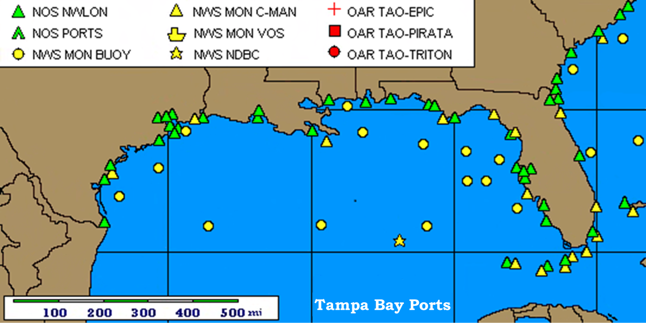
Marine Surface Observations
Select a Symbol to get the Observation
Follow us on X
Follow us on Facebook
Follow us on YouTube
TBW RSS Feed