Overview
Low pressure tracked from the southern Great Lakes toward central New York on December 12th, producing a period of light to moderate snow across much of the forecast area. The heaviest snow organized in a broad band from the Saratoga area north to the southern Adirondacks. This band of heavier snow was fairly persistent over the northern half to one third of the forecast area into the afternoon on the 12th. Farther south, the precipitation became spottier. The atmosphere was cold enough for snow across the entire area in the morning, however warm air gradually moved north up the Hudson Valley allowing snow showers to change to rain showers as far north as the Mohawk River by noon. Meanwhile, a more persistent, heavier snow continued across the southern Adirondacks, upper Hudson Valley and Green Mountains. Snowfall totals ranged from an inch or two in the Hudson Valley from the Capital District southward, up to a foot or more across the southern Adirondacks, Lake George Saratoga region, and southern Vermont.Snow/Ice
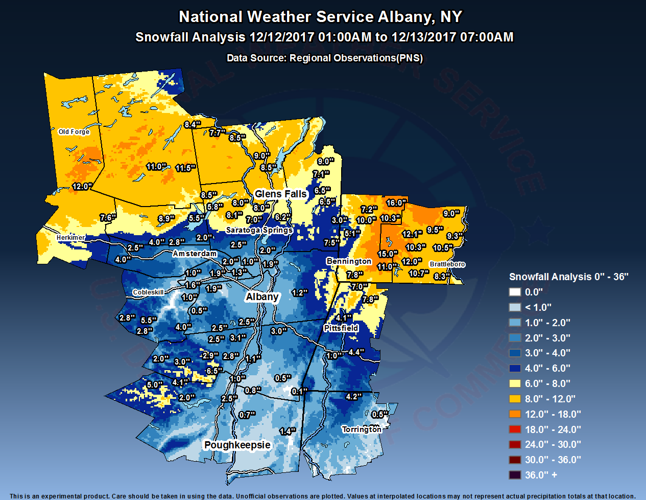
Click image for larger version
Public Information Statement
Spotter Reports
National Weather Service Albany NY
110 PM EST Wed Dec 13 2017

The following are unofficial storm total snowfall observations taken
during the past 32 hours. Appreciation is extended to highway
departments, cooperative observers, Skywarn spotters and media for
these reports. This summary also is available on our home page at
weather.gov/albany

********************STORM TOTAL SNOWFALL********************

LOCATION          STORM TOTAL     TIME/DATE   COMMENTS
                     SNOWFALL           OF
                     /INCHES/   MEASUREMENT

CONNECTICUT

...Litchfield County...
   Norfolk                4.2   800 AM 12/13  Co-Op Observer
   Bakersville            0.5   700 AM 12/13  Co-Op Observer
   3 SW New Hartford      0.5   700 AM 12/13  CoCoRaHS

MASSACHUSETTS

...Berkshire County...
   Savoy                  7.8  1016 PM 12/12  WeatherNet6
   Clarksburg             7.0   459 AM 12/13  WeatherNet6
   5 NW Otis              4.4   700 AM 12/13  CoCoRaHS
   Pittsfield             4.1   405 PM 12/12  WeatherNet6
   1 SE Housatonic        1.0   700 AM 12/13  CoCoRaHS

NEW YORK

...Albany County...
   Westmere               2.5  1042 AM 12/12  Snow mixing with rain.
   Alcove Dam             2.5   730 AM 12/13  Co-Op Observer
   2 SSW Altamont         1.9   655 AM 12/13  CoCoRaHS
   Knox                   1.6  1051 AM 12/12  WeatherNet6
   Albany                 1.5   700 AM 12/13  CoCoRaHS
   1 W Albany             1.4   700 AM 12/13  CoCoRaHS
   2 S Colonie            1.3   700 AM 12/13  CoCoRaHS
   1 NE Shakers           1.3   100 PM 12/12  ASOS
   1 S Westmere           1.0  1000 AM 12/12  NWS Employee
   Colonie                1.0   443 PM 12/12  WeatherNet6

...Columbia County...
   Kinderhook             3.0   900 AM 12/12  Trained Spotter
   Taghkanic              0.5   707 AM 12/13  WeatherNet6
   Ancramdale             0.1   458 AM 12/13  WeatherNet6

...Dutchess County...
   3 SE Millbrook         1.4   700 AM 12/13  CoCoRaHS
   Red Hook               0.8  1047 AM 12/12  WeatherNet6
   Rhinebeck              0.7   826 AM 12/12  Public

...Fulton County...
   7 NW GLOVERSVILLE      8.9   700 AM 12/13  Co-Op Observer
   Northville             8.5   943 PM 12/12  WeatherNet6
   Fishhouse              5.5   354 PM 12/12  WeatherNet6
   Perth                  2.0   416 PM 12/12  WeatherNet6

...Greene County...
   Platte Clove           6.5   500 PM 12/12  Co-Op Observer
   4 NNE Cairo            3.1   530 AM 12/13  CoCoRaHS
   West Kill              3.0  1013 AM 12/12  WeatherNet6
   East Jewett            2.9   620 AM 12/13  Co-Op Observer
   Cairo                  2.8   404 PM 12/12  WeatherNet6
   7 SSE Westerlo         2.5   500 AM 12/13  CoCoRaHS
   Greenville Center      2.5   319 PM 12/12  WeatherNet6
   Halcott Center         2.0   438 PM 12/12  WeatherNet6
   Catskill               1.1   820 AM 12/12  WeatherNet6

...Hamilton County...
   Wells                 11.5   422 PM 12/12  WeatherNet6
   3 ENE Piseco          11.0   700 AM 12/13  CoCoRaHS
   2 SW Indian Lake       8.4   750 AM 12/13  Co-Op Observer

...Herkimer County...
   Ohio                  12.0   710 AM 12/13  Public
   2 NW Dolgeville        7.6   700 AM 12/13  CoCoRaHS

...Montgomery County...
   4 ESE Ephratah         4.0  1230 PM 12/12  CoCoRaHS
   4 ENE East Springfie   4.0   800 AM 12/13  CoCoRaHS
   Fonda                  2.8  1037 AM 12/12  WeatherNet6
   Fort Plain             2.5   700 AM 12/13  CoCoRaHS
   Amsterdam              1.5   953 PM 12/12  WeatherNet6

...Rensselaer County...
   Averill Park           1.2   800 AM 12/13  CoCoRaHS

...Saratoga County...
   Lake Desolation        8.1   406 PM 12/12  WeatherNet6
   Corinth                8.0   502 PM 12/12  WeatherNet6
   1 SSE Porter Corners   7.0   735 AM 12/13  CoCoRaHS
   1 W Gansevoort         6.2   600 AM 12/13  CoCoRaHS
   Edinburg               5.8   319 PM 12/12  WeatherNet6
   5 NNE Saratoga Sprin   5.0   145 PM 12/12  Trained Spotter
   Saratoga Springs       3.9  1204 PM 12/12  WeatherNet6
   Charlton               2.5   426 PM 12/12  WeatherNet6
   Malta                  2.0   936 PM 12/12  WeatherNet6
   2 S Clifton Park Cen   1.9  1105 AM 12/12  PRESENT WX LIGHT RAIN

...Schenectady County...
   Glenville              2.0   447 PM 12/12  WeatherNet6
   Schenectady            1.9   505 PM 12/12  WeatherNet6
   Schenectady-GE Plot    1.3   800 AM 12/12  NWS Employee
   Duanesburg             1.0   532 AM 12/12  WeatherNet6
   1 SSW Aqueduct         1.0   530 AM 12/12  NWS Employee

...Schoharie County...
   Ruth                   5.5   504 AM 12/13  WeatherNet6
   Gilboa                 4.0   930 PM 12/12  WeatherNet6
   Charlotteville         2.8   438 PM 12/12  WeatherNet6
   Jefferson              2.8   411 PM 12/12  WeatherNet6
   Schoharie              1.0  1035 AM 12/12  WeatherNet6
   Middleburgh            0.5   537 AM 12/12  WeatherNet6

...Ulster County...
   Highmount              5.0   641 AM 12/13  WeatherNet6
   Phoenicia              4.1   437 PM 12/12  WeatherNet6
   Lincoln Park           2.5   700 AM 12/13  CoCoRaHS
   West Shokan            2.0   605 AM 12/13  WeatherNet6
   Saugerties             1.0   437 PM 12/12  WeatherNet6

...Warren County...
   Queensbury            10.2   306 PM 12/12  WeatherNet6
   2 WNW Warrensburg      9.0   800 AM 12/13  CoCoRaHS
   Glens Falls            8.7   619 PM 12/12  Trained Spotter
   Warrensburg            8.5   508 PM 12/12  WeatherNet6
   North Creek            8.5   725 PM 12/12  Trained Spotter
   LAKE LUZERNE           8.0   600 AM 12/13  Co-Op Observer
   5 SE North Creek       7.7   700 AM 12/13  Co-Op Observer

...Washington County...
   Whitehall              9.0   800 AM 12/13  Co-Op Observer
   4 NE Hartford          7.1   940 AM 12/13  Storm total
   1 NNW Fort Edward      7.0   200 PM 12/12  Trained Spotter
   5 SW NORTH HEBRON      6.5   700 AM 12/13  Co-Op Observer
   Hebron                 6.5   526 AM 12/13  WeatherNet6
   Hudson Falls           6.4   541 AM 12/13  WeatherNet6

VERMONT

...Bennington County...
   Landgrove             16.0   539 AM 12/13  WeatherNet6
   Woodford              15.0   556 AM 12/13  WeatherNet6
   1 WNW Weston          12.0   650 AM 12/13  CoCoRaHS
   1 E Manchester Cente  10.3   700 AM 12/13  CoCoRaHS
   Manchester Center     10.0   608 AM 12/13  WeatherNet6
   Pownal                 7.8   503 PM 12/12  WeatherNet6
   5 N North Bennington   7.5   740 AM 12/13  CoCoRaHS
   Manchester             7.2   457 PM 12/12  WeatherNet6
   5 SW Arlington         5.1  1053 PM 12/12  Facebook
   West Arlington         3.0   437 AM 12/13  WeatherNet6

...Windham County...
   1 ESE West Wardsboro  12.1   920 AM 12/13  CoCoRaHS
   1 WNW Wilmington      12.0   616 AM 12/13  CoCoRaHS
   Wilmington            11.0   825 PM 12/12  WeatherNet6
   Marlboro              10.7   700 AM 12/13  Co-Op Observer
   Putney                10.5   725 PM 12/12  Trained Spotter
   5 SE West Wardsboro   10.3   630 AM 12/13  CoCoRaHS
   Townshend              9.5   356 PM 12/12  Facebook
   2 NNW Putney           9.3   700 AM 12/13  CoCoRaHS
   3 WSW Charlestown      9.0   700 AM 12/13  CoCoRaHS
   3 SE West Brattlebor   8.3   829 PM 12/12  Public

&&

*****METADATA*****
:12/13/2017,  800 AM, CT, Litchfield, Norfolk, , , 41.97250, -73.22083, SNOW, 4.2, Inch, Co-Op Observer,
:12/13/2017,  700 AM, CT, Litchfield, Bakersville, , , 41.85833, -73.01028, SNOW, 0.5, Inch, Co-Op Observer,
:12/13/2017,  700 AM, CT, Litchfield, New Hartford, 3, SW, 41.84170, -73.00920, SNOW, 0.5, Inch, CoCoRaHS,
:12/12/2017, 1016 PM, MA, Berkshire, Savoy, , , 42.59784, -73.04357, SNOW, 7.8, Inch, WeatherNet6,
:12/13/2017,  459 AM, MA, Berkshire, Clarksburg, , , 42.73341, -73.07248, SNOW, 7.0, Inch, WeatherNet6,
:12/13/2017,  700 AM, MA, Berkshire, Otis, 5, NW, 42.25906, -73.13213, SNOW, 4.4, Inch, CoCoRaHS,
:12/12/2017,  405 PM, MA, Berkshire, Pittsfield, , , 42.47885, -73.27406, SNOW, 4.1, Inch, WeatherNet6,
:12/13/2017,  700 AM, MA, Berkshire, Housatonic, 1, SE, 42.23790, -73.35034, SNOW, 1.0, Inch, CoCoRaHS,
:12/12/2017, 1042 AM, NY, Albany, Westmere, , , 42.68760, -73.87480, SNOW, 2.5, Inch, Twitter, Snow mixing with rain.
:12/13/2017,  730 AM, NY, Albany, Alcove Dam, , , 42.46972, -73.92667, SNOW, 2.5, Inch, Co-Op Observer,
:12/13/2017,  655 AM, NY, Albany, Altamont, 2, SSW, 42.66696, -74.05088, SNOW, 1.9, Inch, CoCoRaHS,
:12/12/2017, 1051 AM, NY, Albany, Knox, , , 42.73170, -74.14485, SNOW, 1.6, Inch, WeatherNet6,
:12/13/2017,  700 AM, NY, Albany, Albany, , , 42.66245, -73.79070, SNOW, 1.5, Inch, CoCoRaHS,
:12/13/2017,  700 AM, NY, Albany, Albany, 1, W, 42.66019, -73.81034, SNOW, 1.4, Inch, CoCoRaHS,
:12/13/2017,  700 AM, NY, Albany, Colonie, 2, S, 42.69180, -73.83109, SNOW, 1.3, Inch, CoCoRaHS,
:12/12/2017,  100 PM, NY, Albany, Shakers, 1, NE, 42.74911, -73.80197, SNOW, 1.3, Inch, ASOS,
:12/12/2017, 1000 AM, NY, Albany, Westmere, 1, S, 42.68000, -73.87000, SNOW, 1.0, Inch, NWS Employee,
:12/12/2017,  443 PM, NY, Albany, Colonie, , , 42.75199, -73.87985, SNOW, 1.0, Inch, WeatherNet6,
:12/12/2017,  900 AM, NY, Columbia, Kinderhook, , , 42.39460, -73.70410, SNOW, 3.0, Inch, Trained Spotter,
:12/13/2017,  707 AM, NY, Columbia, Taghkanic, , , 42.09087, -73.67557, SNOW, 0.5, Inch, WeatherNet6,
:12/13/2017,  458 AM, NY, Columbia, Ancramdale, , , 42.04518, -73.58640, SNOW, 0.1, Inch, WeatherNet6,
:12/13/2017,  700 AM, NY, Dutchess, Millbrook, 3, SE, 41.75230, -73.64880, SNOW, 1.4, Inch, CoCoRaHS,
:12/12/2017, 1047 AM, NY, Dutchess, Red Hook, , , 42.01819, -73.88329, SNOW, 0.8, Inch, WeatherNet6,
:12/12/2017,  826 AM, NY, Dutchess, Rhinebeck, , , 41.92870, -73.90750, SNOW, 0.7, Inch, Public,
:12/13/2017,  700 AM, NY, Fulton, GLOVERSVILLE, 7, NW, 43.11500, -74.42333, SNOW, 8.9, Inch, Co-Op Observer,
:12/12/2017,  943 PM, NY, Fulton, Northville, , , 43.26720, -74.15380, SNOW, 8.5, Inch, WeatherNet6,
:12/12/2017,  354 PM, NY, Fulton, Fishhouse, , , 43.14266, -74.13742, SNOW, 5.5, Inch, WeatherNet6,
:12/12/2017,  416 PM, NY, Fulton, Perth, , , 42.99299, -74.18303, SNOW, 2.0, Inch, WeatherNet6,
:12/12/2017,  500 PM, NY, Greene, Platte Clove, , , 42.13889, -74.09139, SNOW, 6.5, Inch, Co-Op Observer,
:12/13/2017,  530 AM, NY, Greene, Cairo, 4, NNE, 42.36045, -73.98347, SNOW, 3.1, Inch, CoCoRaHS,
:12/12/2017, 1013 AM, NY, Greene, West Kill, , , 42.19762, -74.33047, SNOW, 3.0, Inch, WeatherNet6,
:12/13/2017,  620 AM, NY, Greene, East Jewett, , , 42.23556, -74.14333, SNOW, 2.9, Inch, Co-Op Observer,
:12/12/2017,  404 PM, NY, Greene, Cairo, , , 42.30665, -74.01118, SNOW, 2.8, Inch, WeatherNet6,
:12/13/2017,  500 AM, NY, Greene, Westerlo, 7, SSE, 42.41400, -74.00900, SNOW, 2.5, Inch, CoCoRaHS,
:12/12/2017,  319 PM, NY, Greene, Greenville Center, , , 42.41500, -74.00928, SNOW, 2.5, Inch, WeatherNet6,
:12/12/2017,  438 PM, NY, Greene, Halcott Center, , , 42.21773, -74.46866, SNOW, 2.0, Inch, WeatherNet6,
:12/12/2017,  820 AM, NY, Greene, Catskill, , , 42.21614, -73.87092, SNOW, 1.1, Inch, WeatherNet6,
:12/12/2017,  422 PM, NY, Hamilton, Wells, , , 43.43943, -74.31615, SNOW, 11.5, Inch, WeatherNet6,
:12/13/2017,  700 AM, NY, Hamilton, Piseco, 3, ENE, 43.45133, -74.47115, SNOW, 11.0, Inch, CoCoRaHS,
:12/13/2017,  750 AM, NY, Hamilton, Indian Lake, 2, SW, 43.75556, -74.27639, SNOW, 8.4, Inch, Co-Op Observer,
:12/13/2017,  710 AM, NY, Herkimer, Ohio, , , 43.32220, -74.97870, SNOW, 12.0, Inch, Public,
:12/13/2017,  700 AM, NY, Herkimer, Dolgeville, 2, NW, 43.12320, -74.79736, SNOW, 7.6, Inch, CoCoRaHS,
:12/12/2017, 1230 PM, NY, Montgomery, Ephratah, 4, ESE, 42.96428, -74.47564, SNOW, 4.0, Inch, CoCoRaHS,
:12/13/2017,  800 AM, NY, Montgomery, East Springfield, 4, ENE, 42.86430, -74.72140, SNOW, 4.0, Inch, CoCoRaHS,
:12/12/2017, 1037 AM, NY, Montgomery, Fonda, , , 42.96961, -74.37194, SNOW, 2.8, Inch, WeatherNet6,
:12/13/2017,  700 AM, NY, Montgomery, Fort Plain, , , 42.92999, -74.62643, SNOW, 2.5, Inch, CoCoRaHS,
:12/12/2017,  953 PM, NY, Montgomery, Amsterdam, , , 42.95513, -74.20550, SNOW, 1.5, Inch, WeatherNet6,
:12/13/2017,  800 AM, NY, Rensselaer, Averill Park, , , 42.63910, -73.56980, SNOW, 1.2, Inch, CoCoRaHS,
:12/12/2017,  406 PM, NY, Saratoga, Lake Desolation, , , 43.13741, -73.97612, SNOW, 8.1, Inch, WeatherNet6,
:12/12/2017,  502 PM, NY, Saratoga, Corinth, , , 43.23563, -73.83334, SNOW, 8.0, Inch, WeatherNet6,
:12/13/2017,  735 AM, NY, Saratoga, Porter Corners, 1, SSE, 43.12684, -73.87859, SNOW, 7.0, Inch, CoCoRaHS,
:12/13/2017,  600 AM, NY, Saratoga, Gansevoort, 1, W, 43.20030, -73.67550, SNOW, 6.2, Inch, CoCoRaHS,
:12/12/2017,  319 PM, NY, Saratoga, Edinburg, , , 43.19250, -74.11430, SNOW, 5.8, Inch, WeatherNet6,
:12/12/2017,  145 PM, NY, Saratoga, Saratoga Springs, 5, NNE, 43.14200, -73.74320, SNOW, 5.0, Inch, Trained Spotter,
:12/12/2017, 1204 PM, NY, Saratoga, Saratoga Springs, , , 43.06388, -73.77926, SNOW, 3.9, Inch, WeatherNet6,
:12/12/2017,  426 PM, NY, Saratoga, Charlton, , , 42.94816, -73.93747, SNOW, 2.5, Inch, WeatherNet6,
:12/12/2017,  936 PM, NY, Saratoga, Malta, , , 42.97524, -73.79354, SNOW, 2.0, Inch, WeatherNet6,
:12/12/2017, 1105 AM, NY, Saratoga, Clifton Park Center, 2, S, 42.84390, -73.77700, SNOW, 1.9, Inch, Retired NWS Emp., PRESENT WX LIGHT RAIN
:12/12/2017,  447 PM, NY, Schenectady, Glenville, , , 42.84118, -73.96713, SNOW, 2.0, Inch, WeatherNet6,
:12/12/2017,  505 PM, NY, Schenectady, Schenectady, , , 42.79506, -73.99018, SNOW, 1.9, Inch, WeatherNet6,
:12/12/2017,  800 AM, NY, Schenectady, Schenectady-GE Plot, , , 42.81491, -73.91816, SNOW, 1.3, Inch, NWS Employee,
:12/12/2017,  532 AM, NY, Schenectady, Duanesburg, , , 42.76791, -74.18184, SNOW, 1.0, Inch, WeatherNet6,
:12/12/2017,  530 AM, NY, Schenectady, Aqueduct, 1, SSW, 42.84040, -73.89450, SNOW, 1.0, Inch, NWS Employee,
:12/13/2017,  504 AM, NY, Schoharie, Ruth, , , 42.46320, -74.54031, SNOW, 5.5, Inch, WeatherNet6,
:12/12/2017,  930 PM, NY, Schoharie, Gilboa, , , 42.41944, -74.31626, SNOW, 4.0, Inch, WeatherNet6,
:12/12/2017,  438 PM, NY, Schoharie, Charlotteville, , , 42.52004, -74.69606, SNOW, 2.8, Inch, WeatherNet6,
:12/12/2017,  411 PM, NY, Schoharie, Jefferson, , , 42.45817, -74.58128, SNOW, 2.8, Inch, WeatherNet6,
:12/12/2017, 1035 AM, NY, Schoharie, Schoharie, , , 42.65750, -74.29587, SNOW, 1.0, Inch, WeatherNet6,
:12/12/2017,  537 AM, NY, Schoharie, Middleburgh, , , 42.56254, -74.23281, SNOW, 0.5, Inch, WeatherNet6,
:12/13/2017,  641 AM, NY, Ulster, Highmount, , , 42.12422, -74.49940, SNOW, 5.0, Inch, WeatherNet6,
:12/12/2017,  437 PM, NY, Ulster, Phoenicia, , , 42.06591, -74.33754, SNOW, 4.1, Inch, WeatherNet6,
:12/13/2017,  700 AM, NY, Ulster, Lincoln Park, , , 41.96104, -73.99577, SNOW, 2.5, Inch, CoCoRaHS,
:12/13/2017,  605 AM, NY, Ulster, West Shokan, , , 41.96782, -74.29412, SNOW, 2.0, Inch, WeatherNet6,
:12/12/2017,  437 PM, NY, Ulster, Saugerties, , , 42.11340, -73.98871, SNOW, 1.0, Inch, WeatherNet6,
:12/12/2017,  306 PM, NY, Warren, Queensbury, , , 43.32610, -73.68980, SNOW, 10.2, Inch, WeatherNet6,
:12/13/2017,  800 AM, NY, Warren, Warrensburg, 2, WNW, 43.51785, -73.81069, SNOW, 9.0, Inch, CoCoRaHS,
:12/12/2017,  619 PM, NY, Warren, Glens Falls, , , 43.31110, -73.64550, SNOW, 8.7, Inch, Trained Spotter,
:12/12/2017,  508 PM, NY, Warren, Warrensburg, , , 43.49005, -73.78656, SNOW, 8.5, Inch, WeatherNet6,
:12/12/2017,  725 PM, NY, Warren, North Creek, , , 43.69730, -73.98570, SNOW, 8.5, Inch, Trained Spotter,
:12/13/2017,  600 AM, NY, Warren, LAKE LUZERNE, , , 43.26139, -73.83417, SNOW, 8.0, Inch, Co-Op Observer,
:12/13/2017,  700 AM, NY, Warren, North Creek, 5, SE, 43.70083, -73.98333, SNOW, 7.7, Inch, Co-Op Observer,
:12/13/2017,  800 AM, NY, Washington, Whitehall, , , 43.55750, -73.40111, SNOW, 9.0, Inch, Co-Op Observer,
:12/13/2017,  940 AM, NY, Washington, Hartford, 4, NE, 43.42385, -73.33506, SNOW, 7.1, Inch, Emergency Manager, Storm total
:12/12/2017,  200 PM, NY, Washington, Fort Edward, 1, NNW, 43.27669, -73.58635, SNOW, 7.0, Inch, Trained Spotter,
:12/13/2017,  700 AM, NY, Washington, NORTH HEBRON, 5, SW, 43.29556, -73.39833, SNOW, 6.5, Inch, Co-Op Observer,
:12/13/2017,  526 AM, NY, Washington, Hebron, , , 43.29663, -73.39906, SNOW, 6.5, Inch, WeatherNet6,
:12/13/2017,  541 AM, NY, Washington, Hudson Falls, , , 43.30668, -73.57665, SNOW, 6.4, Inch, WeatherNet6,
:12/13/2017,  539 AM, VT, Bennington, Landgrove, , , 43.29158, -72.83854, SNOW, 16.0, Inch, WeatherNet6,
:12/13/2017,  556 AM, VT, Bennington, Woodford, , , 42.88864, -73.01248, SNOW, 15.0, Inch, WeatherNet6,
:12/13/2017,  650 AM, VT, Bennington, Weston, 1, WNW, 43.29092, -72.83260, SNOW, 12.0, Inch, CoCoRaHS,
:12/13/2017,  700 AM, VT, Bennington, Manchester Center, 1, E, 43.17275, -73.01811, SNOW, 10.3, Inch, CoCoRaHS,
:12/13/2017,  608 AM, VT, Bennington, Manchester Center, , , 43.17283, -73.01814, SNOW, 10.0, Inch, WeatherNet6,
:12/12/2017,  503 PM, VT, Bennington, Pownal, , , 42.79083, -73.23237, SNOW, 7.8, Inch, WeatherNet6,
:12/13/2017,  740 AM, VT, Bennington, North Bennington, 5, N, 43.00556, -73.24743, SNOW, 7.5, Inch, CoCoRaHS,
:12/12/2017,  457 PM, VT, Bennington, Manchester, , , 43.17323, -73.04768, SNOW, 7.2, Inch, WeatherNet6,
:12/12/2017, 1053 PM, VT, Bennington, Arlington, 5, SW, 43.02000, -73.23000, SNOW, 5.1, Inch, Facebook,
:12/13/2017,  437 AM, VT, Bennington, West Arlington, , , 43.10395, -73.23788, SNOW, 3.0, Inch, WeatherNet6,
:12/13/2017,  920 AM, VT, Windham, West Wardsboro, 1, ESE, 43.01690, -72.82840, SNOW, 12.1, Inch, CoCoRaHS,
:12/13/2017,  616 AM, VT, Windham, Wilmington, 1, WNW, 42.87064, -72.88184, SNOW, 12.0, Inch, CoCoRaHS,
:12/12/2017,  825 PM, VT, Windham, Wilmington, , , 42.87069, -72.88169, SNOW, 11.0, Inch, WeatherNet6,
:12/13/2017,  700 AM, VT, Windham, Marlboro, , , 42.83778, -72.73500, SNOW, 10.7, Inch, Co-Op Observer,
:12/12/2017,  725 PM, VT, Windham, Putney, , , 42.97400, -72.52030, SNOW, 10.5, Inch, Trained Spotter,
:12/13/2017,  630 AM, VT, Windham, West Wardsboro, 5, SE, 42.97658, -72.77638, SNOW, 10.3, Inch, CoCoRaHS,
:12/12/2017,  356 PM, VT, Windham, Townshend, , , 43.04300, -72.66600, SNOW, 9.5, Inch, Facebook,
:12/13/2017,  700 AM, VT, Windham, Putney, 2, NNW, 43.00335, -72.53336, SNOW, 9.3, Inch, CoCoRaHS,
:12/13/2017,  700 AM, VT, Windham, Charlestown, 3, WSW, 43.20389, -72.48222, SNOW, 9.0, Inch, CoCoRaHS,
:12/12/2017,  829 PM, VT, Windham, West Brattleboro, 3, SE, 42.82000, -72.58000, SNOW, 8.3, Inch, Public,
Radar:
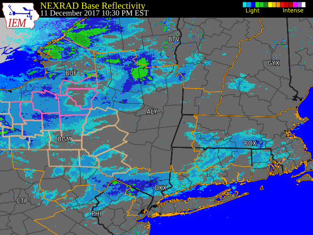 |
| KENX radar loop 10:30 pm Dec. 11 through 10:00 pm Dec. 12. Click image for larger version. |
 |
Media use of NWS Web News Stories is encouraged! Please acknowledge the NWS as the source of any news information accessed from this site. |
|

