Overview
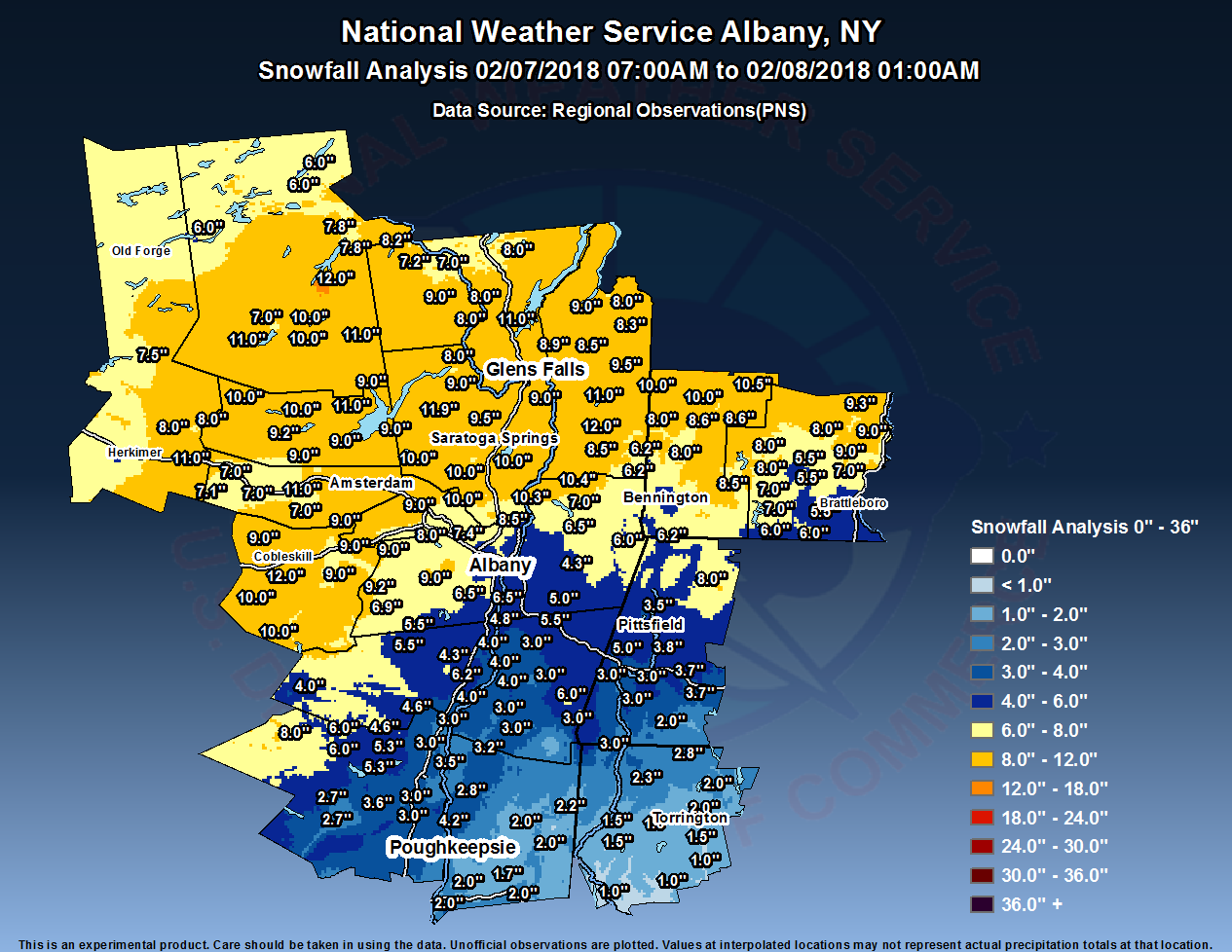
Accumulating snowfall developed during the morning of February 7th as strong southerly winds brought in moisture with origins from the Gulf of America. These winds also allowed snow to change to sleet and freezing rain from south to north during the afternoon hours, which cut down on snowfall totals from the Capital District and Berkshires on south. Highest totals were observed over the Schoharie and Mohawk Valleys, southern Adirondacks, Lake George Saratoga region, and the southern Green Mountains, where generally 8 to 12 inches occurred. Totals were in the 5 to 9 inch range across the Capital District, while 2 to 5 inches along with some light icing occurred in the mid Hudson Valley and eastern Catskills. The snowfall ended from west to east during the evening hours.Snow/Ice
Public Information Statement
Spotter Reports
National Weather Service Albany NY
744 AM EST Fri Feb 09 2018
The following are unofficial final observations from the February 7
snow storm. Appreciation is extended to highway departments,
cooperative observers, Skywarn spotters and media for these reports.
This summary also is available on our home page at weather.gov/albany
********************STORM TOTAL SNOWFALL********************
LOCATION STORM TOTAL TIME/DATE COMMENTS
SNOWFALL OF
/INCHES/ MEASUREMENT
CONNECTICUT
...Litchfield County...
Canaan 3.0 1100 PM 2/07 WeatherNet6
Colebrook 2.8 1100 PM 2/07 CoCoRaHS
5 NNW Winsted 2.8 700 AM 2/08 CoCoRaHS
Norfolk 2.3 800 AM 2/08 Co-Op Observer
Barkhamsted 2.0 800 AM 2/08 Co-Op Observer
Bakersville 2.0 700 AM 2/08 Co-Op Observer
3 SW New Hartford 2.0 700 AM 2/08 CoCoRaHS
Harwinton 1.5 1100 PM 2/07 Trained Spotter
4 SSW Cornwall Bridg 1.5 700 AM 2/08 CoCoRaHS
2 NE Litchfield 1.3 700 AM 2/08 CoCoRaHS
Thomaston Dam 1.0 700 AM 2/08 Co-Op Observer
5 SSW New Milford 1.0 700 AM 2/08 CoCoRaHS
1 WNW Oakville 1.0 720 AM 2/08 CoCoRaHS
Torrington 1.0 1100 PM 2/07 Trained Spotter
MASSACHUSETTS
...Berkshire County...
Savoy 8.0 1100 PM 2/07 WTEN
Pittsfield 6.0 1100 PM 2/07 WTEN
Lenox 5.0 1100 PM 2/07 WTEN
Lenoxdale 3.8 1100 PM 2/07 0.69 liquid equiv
5 NW Otis 3.7 700 AM 2/08 CoCoRaHS
1 NNW Pittsfield 3.5 700 AM 2/08 CoCoRaHS
1 SE Housatonic 3.0 700 AM 2/08 CoCoRaHS
3 NE Housatonic 3.0 600 AM 2/08 CoCoRaHS
Sandisfield 2.0 1100 PM 2/07 Social Media
NEW YORK
...Albany County...
Voorheesville 9.0 1100 PM 2/07 WTEN
Westmere 8.0 1100 PM 2/07 WTEN
Altamont 7.5 1100 PM 2/07 WTEN
3 NW Guilderland 7.4 800 PM 2/07 NWS Employee
5 WNW Westerlo 6.9 700 AM 2/08 CoCoRaHS
Boght Corners 6.6 800 PM 2/07 NWS Employee
2 SSW Altamont 6.6 655 AM 2/08 CoCoRaHS
Knox 6.5 734 PM 2/07 WeatherNet6
3 N Selkirk 6.5 700 AM 2/08 CoCoRaHS
2 WNW Guilderland 6.3 700 AM 2/08 CoCoRaHS
1 NE Shakers 6.2 1159 PM 2/07 ASOS
WTEN Studio 6.0 1100 PM 2/07 WTEN
Colonie 6.0 624 PM 2/07 WeatherNet6
Latham 6.0 1100 PM 2/07 WTEN
1 W Albany 5.8 700 AM 2/08 CoCoRaHS
2 W Albany 5.8 900 PM 2/07 Retired NWS Emp.
Delmar 5.7 850 PM 2/07 Facebook
2 S Colonie 5.2 700 AM 2/08 CoCoRaHS
Albany 5.2 700 PM 2/07 Official NWS Obs
Ravena 4.8 500 PM 2/07 Facebook
...Columbia County...
Hillsdale 6.0 1100 PM 2/07 WTEN
North Chatham 5.5 1013 PM 2/07 WeatherNet6
Claverack 4.0 1100 PM 2/07 WTEN
Kinderhook 3.0 615 PM 2/07 Trained Spotter
Livingston 3.0 700 AM 2/08 CoCoRaHS
Philmont 3.0 1100 PM 2/07 WTEN
Copake 3.0 1100 PM 2/07 WTEN
Taghkanic 2.9 637 AM 2/08 WeatherNet6
Ancramdale 1.5 503 AM 2/08 WeatherNet6
...Dutchess County...
Poughkeepsie 3.5 900 AM 2/08 Public
1 NE Red Hook 3.2 700 AM 2/08 CoCoRaHS
Rhinebeck 2.8 1100 PM 2/07 Meteorologist
Red Hook 2.5 1100 PM 2/07 WeatherNet6
Wassaic 2.2 1100 PM 2/07 Trained Spotter
1 NE Fishkill 2.0 700 AM 2/08 CoCoRaHS
3 SE Millbrook 2.0 700 AM 2/08 CoCoRaHS
3 ESE Hopewell Junct 2.0 1100 PM 2/07 Social Media
Hopewell Junction 1.7 1100 PM 2/07 Social Media
2 SSE Hopewell Junct 1.7 700 AM 2/08 CoCoRaHS
6 ESE Pleasant Valle 1.6 700 AM 2/08 CoCoRaHS
Poughquag 1.5 1100 PM 2/07 Social Media
1 WSW Red Oaks Mill 1.3 105 AM 2/08 Trained Spotter
2 N Dover Plains 1.0 1100 PM 2/07 NYS Mesonet
...Fulton County...
Northampton 11.0 700 PM 2/07 Facebook
Stratford 10.0 1100 PM 2/07 WTEN
Caroga Lake 10.0 1100 PM 2/07 WTEN
7 NW GLOVERSVILLE 9.2 700 AM 2/08 Co-Op Observer
Gloversville 9.0 1100 PM 2/07 WTEN
Broadalbin 9.0 633 AM 2/08 WeatherNet6
Northville 9.0 830 AM 2/08 Co-Op Observer
Johnstown 9.0 1100 PM 2/07 WTEN
Mayfield 9.0 1100 PM 2/07 WTEN
Bleecker 9.0 1100 PM 2/07 WTEN
4 WNW Galway 8.0 900 AM 2/08 CoCoRaHS
...Greene County...
Earlton 6.2 909 PM 2/07 WeatherNet6
7 SSE Westerlo 5.5 500 AM 2/08 CoCoRaHS
Greenville Center 5.5 354 AM 2/08 WeatherNet6
Platte Clove 4.6 700 AM 2/08 Co-Op Observer
4 NNE Cairo 4.3 521 AM 2/08 CoCoRaHS
Climax 4.0 1100 PM 2/07 WTEN
Catskill 4.0 1100 PM 2/07 WTEN
Coxsackie 4.0 1100 PM 2/07 WTEN
Halcott Center 4.0 522 PM 2/07 WeatherNet6
...Hamilton County...
Speculator 12.0 1100 PM 2/07 WTEN
Piseco 11.0 1100 PM 2/07 WTEN
Wells 11.0 1100 PM 2/07 WTEN
3 ENE Piseco 10.0 700 AM 2/08 CoCoRaHS
2 SW Indian Lake 7.8 608 AM 2/08 Co-Op Observer
2 NNE Piseco 7.0 700 PM 2/07 NYS Mesonet
Inlet 6.0 1100 PM 2/07 Trained Spotter
Long Lake 6.0 700 AM 2/08 CoCoRaHS
...Herkimer County...
Danube 11.0 1100 PM 2/07 Facebook
2 NW Dolgeville 8.0 700 AM 2/08 CoCoRaHS
Ohio 7.5 1100 PM 2/07 Trained Spotter
Ilion 5.9 800 AM 2/08 CoCoRaHS
...Montgomery County...
Amsterdam 11.2 950 PM 2/07 WeatherNet6
Fultonville 11.0 650 PM 2/07 Facebook
Fonda 7.2 823 PM 2/07 WeatherNet6
4 ENE East Springfie 7.1 800 AM 2/08 CoCoRaHS
Glen 7.0 1000 PM 2/07 WeatherNet6
Fort Plain 7.0 700 AM 2/08 CoCoRaHS
4 ESE Ephratah 6.9 900 AM 2/08 CoCoRaHS
Hessville 6.8 513 PM 2/07 WeatherNet6
...Rensselaer County...
Valley Falls 10.4 800 PM 2/07 Trained Spotter
2 ENE Mechanicville 10.3 910 PM 2/07 Trained Spotter
Pittstown 7.0 1100 PM 2/07 WTEN
5 E Waterford 6.5 700 AM 2/08 CoCoRaHS
Troy 6.0 1100 PM 2/07 WTEN
Berlin 6.0 1025 PM 2/07 Facebook
2 NE Troy 5.7 700 AM 2/08 CoCoRaHS
1 N Sycaway 5.7 1145 PM 2/07 NWS Employee
Brunswick 5.5 630 PM 2/07 Social Media
Hampton Manor 5.0 1200 AM 2/08 Facebook
Nassau 5.0 1100 PM 2/07 WTEN
Averill Park 4.3 800 AM 2/08 CoCoRaHS
1 WNW Averill Park 4.3 908 PM 2/07 Trained Spotter
...Saratoga County...
Lake Desolation 11.9 704 AM 2/08 WeatherNet6
Rock City Falls 10.0 1100 PM 2/07 WTEN
Galway 10.0 1100 PM 2/07 WTEN
2 ESE Ballston Spa 10.0 840 AM 2/08 CoCoRaHS
Jonesville 10.0 725 PM 2/07 Retired NWS employee
Ballston Lake 10.0 1100 PM 2/07 WTEN
1 SSE Porter Corners 9.5 815 AM 2/08 CoCoRaHS
Burnt Hills 9.0 947 PM 2/07 Facebook
1 W Gansevoort 9.0 630 AM 2/08 CoCoRaHS
Wilton 9.0 1100 PM 2/07 WTEN
3 S Saratoga Lake 9.0 700 AM 2/08 CoCoRaHS
Saratoga Springs 9.0 500 AM 2/08 CoCoRaHS
2 SE Clifton Park 8.5 610 AM 2/08 CoCoRaHS
2 NNE Round Lake 8.2 743 PM 2/07 Trained Spotter
2 N Clifton Park 8.0 730 PM 2/07 Twitter
Malta 8.0 905 PM 2/07 WeatherNet6
Clifton Park 8.0 1100 PM 2/07 WTEN
Conklingville Dam 8.0 800 AM 2/08 Co-Op Observer
Schuylerville 8.0 1100 PM 2/07 WTEN
1 WSW Round Lake 7.8 800 AM 2/08 CoCoRaHS
N Ballston Spa 7.8 800 PM 2/07 NWS Employee
Edinburg 7.8 902 PM 2/07 WeatherNet6
2 S Clifton Park Cen 7.4 843 PM 2/07 Retired NWS Emp.
...Schenectady County...
Mariaville 11.0 900 PM 2/07 Facebook
Delanson 9.0 700 AM 2/08 Co-Op Observer
Pattersonville 9.0 1100 PM 2/07 WTEN
4 SSW Pattersonville 8.1 800 AM 2/08 CoCoRaHS
South Schenectady 8.0 700 PM 2/07 NWS Employee
Rotterdam 8.0 800 AM 2/08 CoCoRaHS
Scotia 8.0 1100 PM 2/07 WTEN
1 NNW Niskayuna 7.7 630 PM 2/07 NWS Employee
Schenectady 7.5 700 PM 2/07 Facebook
1 SSW Aqueduct 7.0 650 PM 2/07 NWS Employee
Schenectady-GE Plot 7.0 730 PM 2/07 NWS Employee
Niskayuna 7.0 700 AM 2/08 Co-Op Observer
2 SE Niskayuna 6.5 900 AM 2/08 CoCoRaHS
...Schoharie County...
Richmondville 12.0 845 PM 2/07 Facebook
Cobleskill 10.7 737 PM 2/07 Trained Spotter
Summit 10.0 1100 PM 2/07 WTEN
Jefferson 10.0 539 AM 2/08 WeatherNet6
Middleburgh 9.2 329 AM 2/08 WeatherNet6
Seward 9.0 948 PM 2/07 WeatherNet6
Esperance 9.0 1100 PM 2/07 WTEN
Schoharie 9.0 855 PM 2/07 WeatherNet6
Charlotteville 9.0 312 AM 2/08 WeatherNet6
North Blenheim 8.0 653 AM 2/08 WeatherNet6
7 N North Blenheim 8.0 800 AM 2/08 Co-Op Observer
...Ulster County...
Highmount 8.0 655 AM 2/08 WeatherNet6
Phoenicia 6.0 700 AM 2/08 Co-Op Observer
West Hurley 5.3 930 AM 2/08 CoCoRaHS
Esopus 4.2 955 PM 2/07 Trained Spotter
Wallkill 3.6 700 PM 2/07 Twitter
1 WNW Rosendale Vill 3.6 700 AM 2/08 CoCoRaHS
Lincoln Park 3.5 700 AM 2/08 CoCoRaHS
Lomontville 3.2 530 PM 2/07 Trained Spotter
2 S Hurley 3.0 528 AM 2/08 CoCoRaHS
Rosendale 3.0 1100 PM 2/07 WTEN
2 NW Lake Katrine 3.0 700 AM 2/08 CoCoRaHS
Saugerties 3.0 1100 PM 2/07 WeatherNet6
Kingston 2.9 1100 PM 2/07 Trained Spotter
3 N Kerhonkson 2.7 700 AM 2/08 CoCoRaHS
3 S Port Ewen 2.5 730 AM 2/08 CoCoRaHS
...Warren County...
Warrensburg 11.0 807 PM 2/07 WeatherNet6
Glens Falls 10.0 1100 PM 2/07 WTEN
Queensbury 9.2 956 PM 2/07 WeatherNet6
Lake Luzerne 9.0 435 AM 2/08 WeatherNet6
Johnsburg 9.0 715 PM 2/07 Facebook
3 NNE Glens Falls 8.9 700 AM 2/08 CoCoRaHS
North River 8.2 910 PM 2/07 Trained Spotter
2 WNW Warrensburg 8.0 800 AM 2/08 CoCoRaHS
Brant Lake 8.0 630 PM 2/07 Facebook
5 SE North Creek 7.2 700 AM 2/08 Co-Op Observer
North Creek 7.0 630 PM 2/07 Facebook
...Washington County...
Greenwich 12.0 1100 PM 2/07 WTEN
Argyle 11.0 1100 PM 2/07 WTEN
Hebron 10.0 1100 PM 2/07 WTEN
Granville 10.0 1100 PM 2/07 WTEN
5 SW NORTH HEBRON 9.5 700 AM 2/08 Co-Op Observer
Whitehall 9.0 1100 PM 2/07 WTEN
Hartford 8.5 830 PM 2/07 Trained Spotter
4 E North Easton 8.5 645 PM 2/07 Trained Spotter
4 NE Hartford 8.3 834 PM 2/07 Emergency Manager
Hudson Falls 8.1 532 AM 2/08 WeatherNet6
VERMONT
...Bennington County...
1 WNW Weston 10.5 715 AM 2/08 CoCoRaHS
Landgrove 10.5 600 AM 2/08 WeatherNet6
Dorset 10.0 1100 PM 2/07 WTEN
1 E Manchester Cente 8.6 700 AM 2/08 CoCoRaHS
Woodford 8.5 657 AM 2/08 WeatherNet6
Shaftsbury 8.0 1100 PM 2/07 WTEN
West Arlington 8.0 453 AM 2/08 WeatherNet6
5 N North Bennington 6.2 800 AM 2/08 CoCoRaHS
Pownal 6.2 518 PM 2/07 WeatherNet6
Bennington 5.0 1100 PM 2/07 WTEN
...Windham County...
3 WSW Charlestown 9.3 700 AM 2/08 CoCoRaHS
3 W Westminster 9.0 800 AM 2/08 CoCoRaHS
Putney 8.5 800 AM 2/08 Social Media
Athens 8.0 800 PM 2/07 Trained Spotter
1 ESE West Wardsboro 8.0 920 AM 2/08 CoCoRaHS
2 NNW Putney 7.0 700 AM 2/08 CoCoRaHS
Wilmington 7.0 1200 AM 2/08 Utility Company
1 WNW Wilmington 7.0 614 AM 2/08 CoCoRaHS
2 ESE Jacksonville 6.0 805 AM 2/08 CoCoRaHS
5 SE West Wardsboro 5.5 700 AM 2/08 CoCoRaHS
Marlboro 5.5 800 AM 2/08 Co-Op Observer
Brattleboro 4.5 700 PM 2/07 Facebook
**********************24 HOUR SNOWFALL**********************
LOCATION 24 HOUR TIME/DATE COMMENTS
SNOWFALL OF
/INCHES/ MEASUREMENT
CONNECTICUT
...Litchfield County...
5 NNW Winsted 2.8 700 AM 2/08 CoCoRaHS
Norfolk 2.3 800 AM 2/08 Co-Op Observer
Bakersville 2.0 700 AM 2/08 Co-Op Observer
Barkhamsted 2.0 800 AM 2/08 Co-Op Observer
3 SW New Hartford 2.0 700 AM 2/08 CoCoRaHS
4 SSW Cornwall Bridg 1.5 700 AM 2/08 CoCoRaHS
2 NE Litchfield 1.3 700 AM 2/08 CoCoRaHS
Thomaston Dam 1.0 700 AM 2/08 Co-Op Observer
5 SSW New Milford 1.0 700 AM 2/08 CoCoRaHS
1 WNW Oakville 1.0 720 AM 2/08 CoCoRaHS
MASSACHUSETTS
...Berkshire County...
5 NW Otis 3.7 700 AM 2/08 CoCoRaHS
1 NNW Pittsfield 3.5 700 AM 2/08 CoCoRaHS
1 SE Housatonic 3.0 700 AM 2/08 CoCoRaHS
3 NE Housatonic 3.0 600 AM 2/08 CoCoRaHS
NEW YORK
...Albany County...
5 WNW Westerlo 6.9 700 AM 2/08 CoCoRaHS
2 SSW Altamont 6.6 655 AM 2/08 CoCoRaHS
3 N Selkirk 6.5 700 AM 2/08 CoCoRaHS
2 WNW Guilderland 6.3 700 AM 2/08 CoCoRaHS
1 W Albany 5.8 700 AM 2/08 CoCoRaHS
2 S Colonie 5.2 700 AM 2/08 CoCoRaHS
...Columbia County...
Livingston 3.0 700 AM 2/08 CoCoRaHS
...Dutchess County...
1 NE Red Hook 3.2 700 AM 2/08 CoCoRaHS
Poughkeepsie 2.8 700 AM 2/08 Co-Op Observer
3 SE Millbrook 2.0 700 AM 2/08 CoCoRaHS
1 NE Fishkill 2.0 700 AM 2/08 CoCoRaHS
2 SSE Hopewell Junct 1.7 700 AM 2/08 CoCoRaHS
6 ESE Pleasant Valle 1.6 700 AM 2/08 CoCoRaHS
...Fulton County...
7 NW GLOVERSVILLE 9.2 700 AM 2/08 Co-Op Observer
Northville 9.0 830 AM 2/08 Co-Op Observer
4 WNW Galway 8.0 900 AM 2/08 CoCoRaHS
...Greene County...
7 SSE Westerlo 5.5 500 AM 2/08 CoCoRaHS
Platte Clove 4.6 700 AM 2/08 Co-Op Observer
4 NNE Cairo 4.3 521 AM 2/08 CoCoRaHS
...Hamilton County...
3 ENE Piseco 10.0 700 AM 2/08 CoCoRaHS
2 SW Indian Lake 7.8 608 AM 2/08 Co-Op Observer
Long Lake 6.0 700 AM 2/08 CoCoRaHS
...Herkimer County...
2 NW Dolgeville 8.0 700 AM 2/08 CoCoRaHS
Ilion 5.9 800 AM 2/08 CoCoRaHS
...Montgomery County...
4 ENE East Springfie 7.1 800 AM 2/08 CoCoRaHS
Fort Plain 7.0 700 AM 2/08 CoCoRaHS
4 ESE Ephratah 6.9 900 AM 2/08 CoCoRaHS
...Rensselaer County...
5 E Waterford 6.5 700 AM 2/08 CoCoRaHS
2 NE Troy 5.7 700 AM 2/08 CoCoRaHS
Troy 5.5 700 AM 2/08 Co-Op Observer
Averill Park 4.3 800 AM 2/08 CoCoRaHS
...Saratoga County...
2 ESE Ballston Spa 10.0 840 AM 2/08 CoCoRaHS
1 SSE Porter Corners 9.5 815 AM 2/08 CoCoRaHS
1 W Gansevoort 9.0 630 AM 2/08 CoCoRaHS
Saratoga Springs 9.0 500 AM 2/08 CoCoRaHS
3 S Saratoga Lake 9.0 700 AM 2/08 CoCoRaHS
2 SE Clifton Park 8.5 610 AM 2/08 CoCoRaHS
Conklingville Dam 8.0 800 AM 2/08 Co-Op Observer
1 WSW Round Lake 7.8 800 AM 2/08 CoCoRaHS
...Schenectady County...
Delanson 9.0 700 AM 2/08 Co-Op Observer
4 SSW Pattersonville 8.1 800 AM 2/08 CoCoRaHS
Rotterdam 8.0 800 AM 2/08 CoCoRaHS
Niskayuna 7.0 700 AM 2/08 Co-Op Observer
2 SE Niskayuna 6.5 900 AM 2/08 CoCoRaHS
...Schoharie County...
7 N North Blenheim 8.0 800 AM 2/08 Co-Op Observer
Schoharie 6.0 715 AM 2/08 Co-Op Observer
...Ulster County...
Phoenicia 6.0 700 AM 2/08 Co-Op Observer
West Hurley 5.3 930 AM 2/08 CoCoRaHS
1 WNW Rosendale Vill 3.6 700 AM 2/08 CoCoRaHS
Lincoln Park 3.5 700 AM 2/08 CoCoRaHS
2 NW Lake Katrine 3.0 700 AM 2/08 CoCoRaHS
2 S Hurley 3.0 528 AM 2/08 CoCoRaHS
3 N Kerhonkson 2.7 700 AM 2/08 CoCoRaHS
3 S Port Ewen 2.5 730 AM 2/08 CoCoRaHS
...Warren County...
Lake Luzerne 9.0 600 AM 2/08 Co-Op Observer
3 NNE Glens Falls 8.9 700 AM 2/08 CoCoRaHS
2 WNW Warrensburg 8.0 800 AM 2/08 CoCoRaHS
5 SE North Creek 7.2 700 AM 2/08 Co-Op Observer
...Washington County...
5 SW NORTH HEBRON 9.5 700 AM 2/08 Co-Op Observer
Whitehall 8.0 800 AM 2/08 Co-Op Observer
VERMONT
...Bennington County...
1 WNW Weston 10.5 715 AM 2/08 CoCoRaHS
1 E Manchester Cente 8.6 700 AM 2/08 CoCoRaHS
5 N North Bennington 6.2 800 AM 2/08 CoCoRaHS
...Windham County...
3 WSW Charlestown 9.3 700 AM 2/08 CoCoRaHS
3 W Westminster 9.0 800 AM 2/08 CoCoRaHS
1 ESE West Wardsboro 8.0 920 AM 2/08 CoCoRaHS
1 WNW Wilmington 7.0 614 AM 2/08 CoCoRaHS
2 NNW Putney 7.0 700 AM 2/08 CoCoRaHS
2 ESE Jacksonville 6.0 805 AM 2/08 CoCoRaHS
Marlboro 5.5 800 AM 2/08 Co-Op Observer
5 SE West Wardsboro 5.5 700 AM 2/08 CoCoRaHS
&&
Radar:
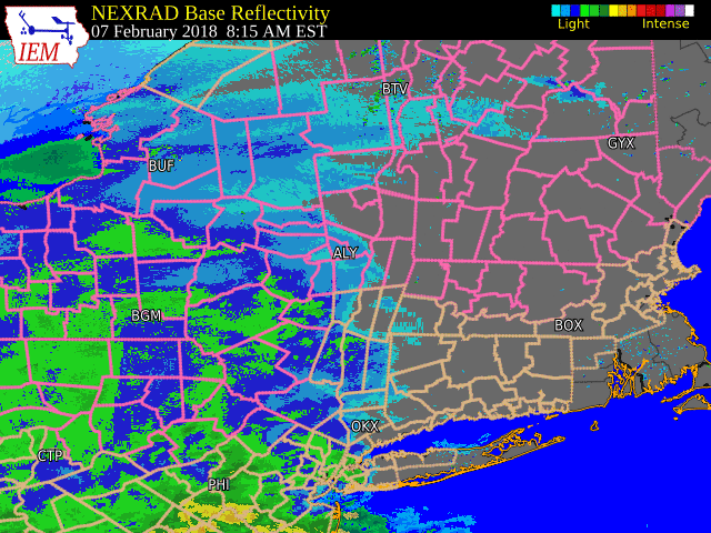 |
| KENX radar reflectivity from 8 am to 10 pm February 7, 2018. Loop courtesy Iowa Environmental Mesonet. Click for larger version. |
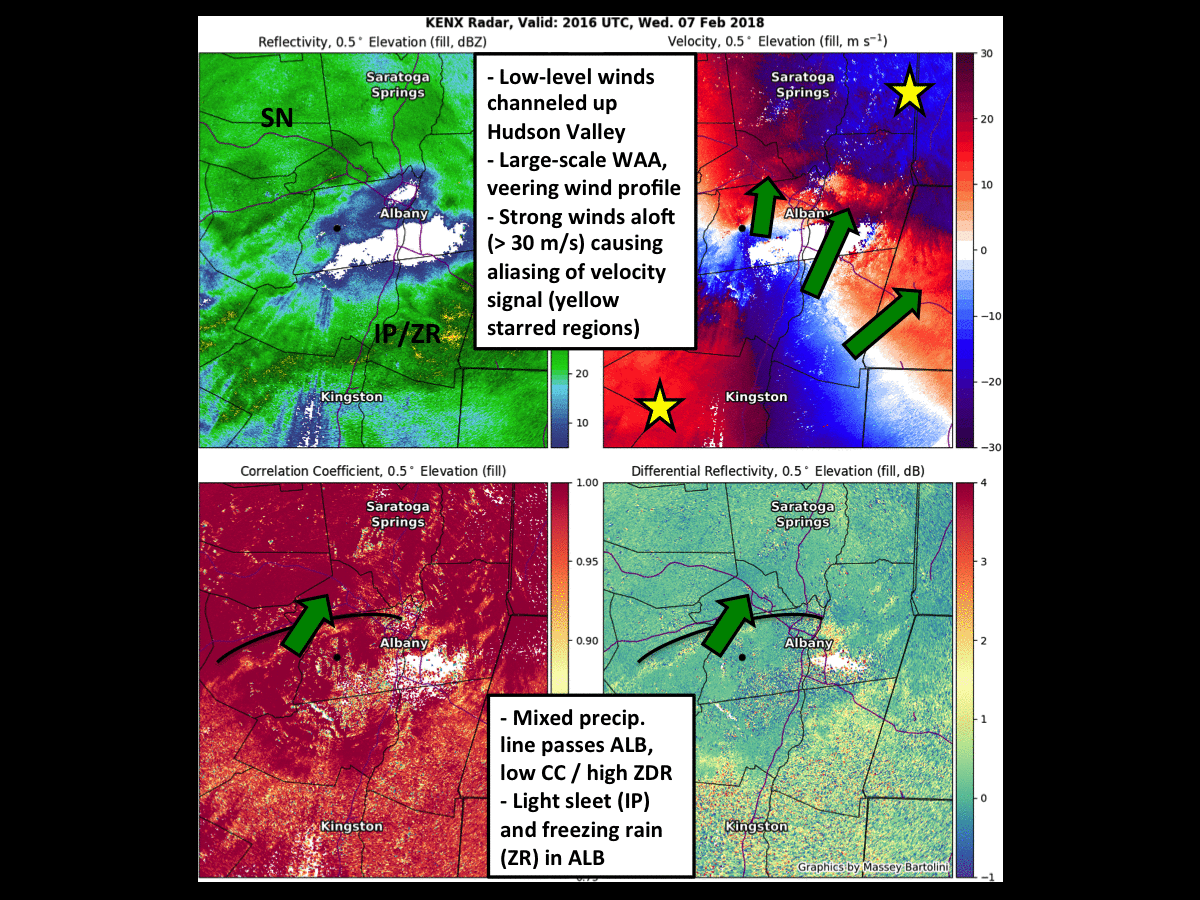 |
| KENX radar from 3:16 pm to 5:19 pm February 7, 2018 showing transition from snow to sleet/freezing rain and back to snow in the Capital District. Loop and annotations courtesy Massey Bartolini, graduate student at the University at Albany, SUNY, in the Department of Atmospheric and Environmental Sciences. Click for larger version. |
 |
Media use of NWS Web News Stories is encouraged! Please acknowledge the NWS as the source of any news information accessed from this site. |
|

