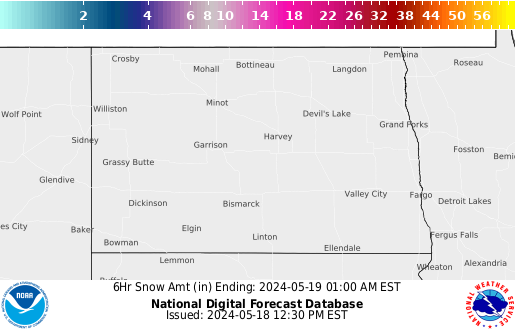
A storm system will continue to slowly move through the Gulf Coast and Southeast U.S. over the next couple of days, bringing a heavy rainfall threat through the weekend. Isolated instances of flooding may occur. On the north side of this storm system, colder air will support areas of mixed wintry precipitation and light snow from the Tennessee Valley to the Mid-Atlantic Friday. Read More >
This page will be around all winter and we constantly update it.BOOKMARK IT! for all your winter weather needs.
|


 Blizzard Warning
 Winter Storm Warning
 Winter Weather Advisory
 Ice Storm Warning
 Freezing Rain Advisory
 Wind Chill Warning
 Blizzard Watch
 Winter Storm Watch
 Special Weather Statement
 High Wind Watch
 High Wind Warning